Narrow Results By
Subject
- Buildings - Industrial - Mills 1
- Buildings - Residential - Houses 6
- Buildings - Schools 3
- Ceremonies - Funerals 4
- Ceremonies - Weddings 1
- Communication Artifacts 2
- Construction Tools and Equipment 6
- Food Service Tools and Equipment 1
- Furniture 1
- Geographic Features - Roads 1
- Industries - Construction 4
- Land Clearing 8
![House on Gilmore Avenue, [193-] thumbnail](/media/hpo/_Data/_BVM_Images/2020/2020_0034_0016_001.jpg?width=280)
House on Gilmore Avenue
https://search.heritageburnaby.ca/link/museumdescription15327
- Repository
- Burnaby Village Museum
- Date
- [193-]
- Collection/Fonds
- Margaret Norton fonds
- Description Level
- Item
- Physical Description
- 1 photograph : b&w hand-tinted col. ; 6.5 x11 cm
- Scope and Content
- Photograph of the Knight-Roberts family home located at 931 Gilmore Avenue in Burnaby. The house was moved from the location of the forty hundred block of Georgia Street in the mid 1920s.
- Repository
- Burnaby Village Museum
- Collection/Fonds
- Margaret Norton fonds
- Description Level
- Item
- Physical Description
- 1 photograph : b&w hand-tinted col. ; 6.5 x11 cm
- Scope and Content
- Photograph of the Knight-Roberts family home located at 931 Gilmore Avenue in Burnaby. The house was moved from the location of the forty hundred block of Georgia Street in the mid 1920s.
- Subjects
- Buildings - Residential - Houses
- Geographic Access
- Gilmore Avenue
- Street Address
- 931 Gilmore Avenue
- Accession Code
- BV020.34.16
- Access Restriction
- No restrictions
- Reproduction Restriction
- No known restrictions
- Date
- [193-]
- Media Type
- Photograph
- Historic Neighbourhood
- Vancouver Heights (Historic Neighbourhood)
- Planning Study Area
- Willingdon Heights Area
- Scan Resolution
- 600
- Scan Date
- March 22, 2021
- Scale
- 100
- Notes
- Title based on contents of photograph
- A rectangular black frame on photograph paper surrounds the photographic image and includes the number "3021" printed in white
Images
![House on Gilmore Avenue, [193-] thumbnail](/media/hpo/_Data/_BVM_Images/2020/2020_0034_0016_001.jpg)
![Houses under construction, [1948] thumbnail](/media/hpo/_Data/_BVM_Images/1971/197100120084.jpg?width=280)
Houses under construction
https://search.heritageburnaby.ca/link/museumdescription16
- Repository
- Burnaby Village Museum
- Date
- [1948]
- Collection/Fonds
- Burnaby Village Museum Photograph collection
- Description Level
- Item
- Physical Description
- 1 photograph : b&w ; 6.7 x 11.2 cm
- Scope and Content
- Photograph of a row of houses being built along a road lined with electric posts. Catalogue information from 1976 indicates that it is a street scene from Burnaby, ca. 1948. This may be the site of the Willingdon Heights subdivision.
- Repository
- Burnaby Village Museum
- Collection/Fonds
- Burnaby Village Museum Photograph collection
- Description Level
- Item
- Physical Description
- 1 photograph : b&w ; 6.7 x 11.2 cm
- Scope and Content
- Photograph of a row of houses being built along a road lined with electric posts. Catalogue information from 1976 indicates that it is a street scene from Burnaby, ca. 1948. This may be the site of the Willingdon Heights subdivision.
- Names
- Bingham, Alfred "Alf"
- Accession Code
- HV971.12.84
- Access Restriction
- No restrictions
- Reproduction Restriction
- No known restrictions
- Date
- [1948]
- Media Type
- Photograph
- Historic Neighbourhood
- Vancouver Heights (Historic Neighbourhood)
- Planning Study Area
- Willingdon Heights Area
- Scan Resolution
- 600
- Scan Date
- 2023-03-21
- Notes
- Title based on contents of photograph
- Stamp on verso of photograph reads: "278X."
Images
![Houses under construction, [1948] thumbnail](/media/hpo/_Data/_BVM_Images/1971/197100120084.jpg)
![Knight-Roberts family home on Gilmore Avenue, [195-] thumbnail](/media/hpo/_Data/_BVM_Images/2020/2020_0034_0019_001.jpg?width=280)
Knight-Roberts family home on Gilmore Avenue
https://search.heritageburnaby.ca/link/museumdescription15330
- Repository
- Burnaby Village Museum
- Date
- [195-]
- Collection/Fonds
- Margaret Norton fonds
- Description Level
- Item
- Physical Description
- 1 photograph : sepia ; 9 x 6.2 cm
- Scope and Content
- Photograph of the front of the Knight-Roberts family home located at 931 Gilmore Avenue in Burnaby. The house was moved to this location from the forty hundred block of Georgia Street, Vancouver in the mid 1920s.
- Repository
- Burnaby Village Museum
- Collection/Fonds
- Margaret Norton fonds
- Description Level
- Item
- Physical Description
- 1 photograph : sepia ; 9 x 6.2 cm
- Scope and Content
- Photograph of the front of the Knight-Roberts family home located at 931 Gilmore Avenue in Burnaby. The house was moved to this location from the forty hundred block of Georgia Street, Vancouver in the mid 1920s.
- Subjects
- Buildings - Residential - Houses
- Geographic Access
- Gilmore Avenue
- Street Address
- 931 Gilmore Avenue
- Accession Code
- BV020.34.19
- Access Restriction
- No restrictions
- Reproduction Restriction
- No known restrictions
- Date
- [195-]
- Media Type
- Photograph
- Historic Neighbourhood
- Vancouver Heights (Historic Neighbourhood)
- Planning Study Area
- Willingdon Heights Area
- Scan Resolution
- 600
- Scan Date
- March 22, 2021
- Scale
- 100
- Notes
- Title based on contents of photograph
Images
![Knight-Roberts family home on Gilmore Avenue, [195-] thumbnail](/media/hpo/_Data/_BVM_Images/2020/2020_0034_0019_001.jpg)
![Knight-Roberts family home on Gilmore Avenue, [195-] thumbnail](/media/hpo/_Data/_BVM_Images/2020/2020_0034_0020_001.jpg?width=280)
Knight-Roberts family home on Gilmore Avenue
https://search.heritageburnaby.ca/link/museumdescription15331
- Repository
- Burnaby Village Museum
- Date
- [195-]
- Collection/Fonds
- Margaret Norton fonds
- Description Level
- Item
- Physical Description
- 1 photograph : sepia ; 6.2 x 9 cm
- Scope and Content
- Photograph of the front of the Knight-Roberts family home located at 931 Gilmore Avenue in Burnaby. The house was moved to this location from the forty hundred block of Georgia Street, Vancouver in the mid 1920s.
- Repository
- Burnaby Village Museum
- Collection/Fonds
- Margaret Norton fonds
- Description Level
- Item
- Physical Description
- 1 photograph : sepia ; 6.2 x 9 cm
- Scope and Content
- Photograph of the front of the Knight-Roberts family home located at 931 Gilmore Avenue in Burnaby. The house was moved to this location from the forty hundred block of Georgia Street, Vancouver in the mid 1920s.
- Subjects
- Buildings - Residential - Houses
- Geographic Access
- Gilmore Avenue
- Street Address
- 931 Gilmore Avenue
- Accession Code
- BV020.34.20
- Access Restriction
- No restrictions
- Reproduction Restriction
- No known restrictions
- Date
- [195-]
- Media Type
- Photograph
- Historic Neighbourhood
- Vancouver Heights (Historic Neighbourhood)
- Planning Study Area
- Willingdon Heights Area
- Scan Resolution
- 600
- Scan Date
- March 22, 2021
- Scale
- 100
- Notes
- Title based on contents of photograph
Images
![Knight-Roberts family home on Gilmore Avenue, [195-] thumbnail](/media/hpo/_Data/_BVM_Images/2020/2020_0034_0020_001.jpg)
![Man on a bulldozer, [194-] thumbnail](/media/hpo/_Data/_BVM_Images/1971/197100120077.jpg?width=280)
Man on a bulldozer
https://search.heritageburnaby.ca/link/museumdescription9
- Repository
- Burnaby Village Museum
- Date
- [194-]
- Collection/Fonds
- Burnaby Village Museum Photograph collection
- Description Level
- Item
- Physical Description
- 1 photograph : b&w ; 6.9 x 11.4 cm
- Scope and Content
- Photograph of an unidentified man, possibly the operator, is standing on a bulldozer belonging to "Holmes & Wilson Trucking". Lumber stacks are nearby, and the bulldozer is on a clearing for a house lot. This may be related to the construction of the Willingdon Heights subdivision. Stamped on bac…
- Repository
- Burnaby Village Museum
- Collection/Fonds
- Burnaby Village Museum Photograph collection
- Description Level
- Item
- Physical Description
- 1 photograph : b&w ; 6.9 x 11.4 cm
- Scope and Content
- Photograph of an unidentified man, possibly the operator, is standing on a bulldozer belonging to "Holmes & Wilson Trucking". Lumber stacks are nearby, and the bulldozer is on a clearing for a house lot. This may be related to the construction of the Willingdon Heights subdivision. Stamped on back of photo: "342X."
- Names
- Bingham, Alfred "Alf"
- Accession Code
- HV971.12.77
- Access Restriction
- No restrictions
- Reproduction Restriction
- No known restrictions
- Date
- [194-]
- Media Type
- Photograph
- Historic Neighbourhood
- Vancouver Heights (Historic Neighbourhood)
- Planning Study Area
- Willingdon Heights Area
- Scan Resolution
- 600
- Scan Date
- 2023-03-21
- Notes
- Title based on contents of photograph
Images
![Man on a bulldozer, [194-] thumbnail](/media/hpo/_Data/_BVM_Images/1971/197100120077.jpg)
![Man on a bulldozer, [194-] thumbnail](/media/hpo/_Data/_BVM_Images/1971/197100120078.jpg?width=280)
Man on a bulldozer
https://search.heritageburnaby.ca/link/museumdescription10
- Repository
- Burnaby Village Museum
- Date
- [194-]
- Collection/Fonds
- Burnaby Village Museum Photograph collection
- Description Level
- Item
- Physical Description
- 1 photograph : b&w ; 6.9 x 11.9 cm
- Scope and Content
- Photograph of an unidentified man standing on a bulldozer belonging to "Wm. Edstrom" as written on the machine. The bulldozer is on a clearing nearby houses. This may be related to the construction of the Willingdon Heights subdivision. Stamped on back of the photograph: "342X."
- Repository
- Burnaby Village Museum
- Collection/Fonds
- Burnaby Village Museum Photograph collection
- Description Level
- Item
- Physical Description
- 1 photograph : b&w ; 6.9 x 11.9 cm
- Scope and Content
- Photograph of an unidentified man standing on a bulldozer belonging to "Wm. Edstrom" as written on the machine. The bulldozer is on a clearing nearby houses. This may be related to the construction of the Willingdon Heights subdivision. Stamped on back of the photograph: "342X."
- Names
- Bingham, Alfred "Alf"
- Accession Code
- HV971.12.78
- Access Restriction
- No restrictions
- Reproduction Restriction
- No known restrictions
- Date
- [194-]
- Media Type
- Photograph
- Historic Neighbourhood
- Vancouver Heights (Historic Neighbourhood)
- Planning Study Area
- Willingdon Heights Area
- Scan Resolution
- 600
- Scan Date
- 2023-03-21
- Notes
- Title based on contents of photograph
Images
![Man on a bulldozer, [194-] thumbnail](/media/hpo/_Data/_BVM_Images/1971/197100120078.jpg)
![Man on a bulldozer, [194-] thumbnail](/media/hpo/_Data/_BVM_Images/1971/197100120080.jpg?width=280)
Man on a bulldozer
https://search.heritageburnaby.ca/link/museumdescription12
- Repository
- Burnaby Village Museum
- Date
- [194-]
- Collection/Fonds
- Burnaby Village Museum Photograph collection
- Description Level
- Item
- Physical Description
- 1 photograph : b&w ; 6.8 x 11.3 cm
- Scope and Content
- Photograph of an unidentified man standing on a bulldozer. The bulldozer is on a cleared lot, behind which houses and electric posts along a road can be seen. This may be the site of the Willingdon Heights subdivision. Stamped on the back of the photograph: "345L."
- Repository
- Burnaby Village Museum
- Collection/Fonds
- Burnaby Village Museum Photograph collection
- Description Level
- Item
- Physical Description
- 1 photograph : b&w ; 6.8 x 11.3 cm
- Scope and Content
- Photograph of an unidentified man standing on a bulldozer. The bulldozer is on a cleared lot, behind which houses and electric posts along a road can be seen. This may be the site of the Willingdon Heights subdivision. Stamped on the back of the photograph: "345L."
- Names
- Bingham, Alfred "Alf"
- Accession Code
- HV971.12.80
- Access Restriction
- No restrictions
- Reproduction Restriction
- No known restrictions
- Date
- [194-]
- Media Type
- Photograph
- Historic Neighbourhood
- Vancouver Heights (Historic Neighbourhood)
- Planning Study Area
- Willingdon Heights Area
- Related Material
- the unidentified man in the photograph reappears in photograph HV971.12.81
- Scan Resolution
- 600
- Scan Date
- 2023-03-21
- Notes
- Title based on contents of photograph
Images
![Man on a bulldozer, [194-] thumbnail](/media/hpo/_Data/_BVM_Images/1971/197100120080.jpg)
![Margaret and Louise Knight on steps of family home, [193-] thumbnail](/media/hpo/_Data/_BVM_Images/2020/2020_0034_0014_001.jpg?width=280)
Margaret and Louise Knight on steps of family home
https://search.heritageburnaby.ca/link/museumdescription15325
- Repository
- Burnaby Village Museum
- Date
- [193-]
- Collection/Fonds
- Margaret Norton fonds
- Description Level
- Item
- Physical Description
- 1 photograph : sepia ; 8.7 x 6.4 cm
- Scope and Content
- Photograph of Margaret Norton (nee Knight) (left) and Louise Knight (nee Ellis) (right) seated on the steps of the Knight-Roberts family home with two young girls. The house is located at 931 Gilmore Avenue in Burnaby.
- Repository
- Burnaby Village Museum
- Collection/Fonds
- Margaret Norton fonds
- Description Level
- Item
- Physical Description
- 1 photograph : sepia ; 8.7 x 6.4 cm
- Scope and Content
- Photograph of Margaret Norton (nee Knight) (left) and Louise Knight (nee Ellis) (right) seated on the steps of the Knight-Roberts family home with two young girls. The house is located at 931 Gilmore Avenue in Burnaby.
- Geographic Access
- Gilmore Avenue
- Street Address
- 931 Gilmore Avenue
- Accession Code
- BV020.34.14
- Access Restriction
- No restrictions
- Reproduction Restriction
- No known restrictions
- Date
- [193-]
- Media Type
- Photograph
- Historic Neighbourhood
- Vancouver Heights (Historic Neighbourhood)
- Planning Study Area
- Willingdon Heights Area
- Scan Resolution
- 600
- Scan Date
- March 22, 2021
- Scale
- 100
- Notes
- Title based on contents of photograph
Images
![Margaret and Louise Knight on steps of family home, [193-] thumbnail](/media/hpo/_Data/_BVM_Images/2020/2020_0034_0014_001.jpg)
![Margaret and Naida Knight, [193-] thumbnail](/media/hpo/_Data/_BVM_Images/2020/2020_0034_0021_001.jpg?width=280)
Margaret and Naida Knight
https://search.heritageburnaby.ca/link/museumdescription15332
- Repository
- Burnaby Village Museum
- Date
- [193-]
- Collection/Fonds
- Margaret Norton fonds
- Description Level
- Item
- Physical Description
- 1 photograph : sepia ; 11 x 7 cm
- Scope and Content
- Photograph of Margaret Norton (nee Knight) standing with her sister Naida Hansen (nee Knight). They are standing together in front of a large sign on Hastings Street in Burnaby.
- Repository
- Burnaby Village Museum
- Collection/Fonds
- Margaret Norton fonds
- Description Level
- Item
- Physical Description
- 1 photograph : sepia ; 11 x 7 cm
- Scope and Content
- Photograph of Margaret Norton (nee Knight) standing with her sister Naida Hansen (nee Knight). They are standing together in front of a large sign on Hastings Street in Burnaby.
- Accession Code
- BV020.34.21
- Access Restriction
- No restrictions
- Reproduction Restriction
- No known restrictions
- Date
- [193-]
- Media Type
- Photograph
- Historic Neighbourhood
- Vancouver Heights (Historic Neighbourhood)
- Planning Study Area
- Willingdon Heights Area
- Scan Resolution
- 600
- Scan Date
- March 22, 2021
- Scale
- 100
- Notes
- Title based on contents of photograph
Images
![Margaret and Naida Knight, [193-] thumbnail](/media/hpo/_Data/_BVM_Images/2020/2020_0034_0021_001.jpg)
![Members of the Knight family under tree, [194-] thumbnail](/media/hpo/_Data/_BVM_Images/2020/2020_0034_0023_001.jpg?width=280)
Members of the Knight family under tree
https://search.heritageburnaby.ca/link/museumdescription15334
- Repository
- Burnaby Village Museum
- Date
- [194-]
- Collection/Fonds
- Margaret Norton fonds
- Description Level
- Item
- Physical Description
- 1 photograph : sepia ; 9 x 6.5 cm
- Scope and Content
- Photograph of members of the Knight family (left to right) Naida Hansen (nee Knight), Dolly Walker-Kirkwood (nee Knight), Fred Knight and Lila McKinley (nee Knight) and Margaret Norton (nee Knight) (cut off). The group have their arms around each other and are standing under a willow tree in the ya…
- Repository
- Burnaby Village Museum
- Collection/Fonds
- Margaret Norton fonds
- Description Level
- Item
- Physical Description
- 1 photograph : sepia ; 9 x 6.5 cm
- Scope and Content
- Photograph of members of the Knight family (left to right) Naida Hansen (nee Knight), Dolly Walker-Kirkwood (nee Knight), Fred Knight and Lila McKinley (nee Knight) and Margaret Norton (nee Knight) (cut off). The group have their arms around each other and are standing under a willow tree in the yard of the family home at 931 Gilmore Avenue.
- Names
- Norton, Margaret Knight
- Hansen, Naida Knight
- Knight, Frederick "Fred"
- Walker-Kirkwood, Dolly Knight
- McKinley, Lila Knight
- Geographic Access
- Gilmore Avenue
- Street Address
- 931 Gilmore Avenue
- Accession Code
- BV020.34.23
- Access Restriction
- No restrictions
- Reproduction Restriction
- No known restrictions
- Date
- [194-]
- Media Type
- Photograph
- Historic Neighbourhood
- Vancouver Heights (Historic Neighbourhood)
- Planning Study Area
- Willingdon Heights Area
- Scan Resolution
- 600
- Scan Date
- March 22, 2021
- Scale
- 100
- Notes
- Title based on contents of photograph
Images
![Members of the Knight family under tree, [194-] thumbnail](/media/hpo/_Data/_BVM_Images/2020/2020_0034_0023_001.jpg)

Municipality of Burnaby - Volume XV and Volume XVIII
https://search.heritageburnaby.ca/link/museumdescription8680
- Repository
- Burnaby Village Museum
- Date
- May 1927
- Collection/Fonds
- Burnaby Village Museum Map collection
- Description Level
- File
- Physical Description
- 4 plans on 4 sheets : col. lithographic prints ; 63.5 x 53.5 cm folded to 53 x 31.5 cm
- Scope and Content
- File consists of four pages of plans removed from a bound book containing a series of fire insurance plans of the Municipality of Burnaby. The first two pages are numbered "A" and "B" and are key plans from "GREATER VANCOUVER B.C. / VOLUME XV / Surveyed _ May 1927 / MUNICIPALITY OF / BURNABY", "PLA…
- Repository
- Burnaby Village Museum
- Collection/Fonds
- Burnaby Village Museum Map collection
- Description Level
- File
- Physical Description
- 4 plans on 4 sheets : col. lithographic prints ; 63.5 x 53.5 cm folded to 53 x 31.5 cm
- Material Details
- Scales [1:1200] and [1:6000]
- Scope and Content
- File consists of four pages of plans removed from a bound book containing a series of fire insurance plans of the Municipality of Burnaby. The first two pages are numbered "A" and "B" and are key plans from "GREATER VANCOUVER B.C. / VOLUME XV / Surveyed _ May 1927 / MUNICIPALITY OF / BURNABY", "PLAN DEPT. FIRE BRANCH _ B.C. INSURANCE UNDERWRITERS ASSN.". Key Plan "B" covers plans: 1505; 1506; 1512 to 1516; 1540 to 1544; 1550 to 1557 and District Lots: 129 to 132; 135 to 138; 205 to 208 and 215 to 218. Key Plan "A" covers plans: 1501 to 1504; 1507 to 1511; 1517 to 1525; 1531 to 1539; 1545 to 1550 and District Lots: 116 to 127 and 186 to 189. Plan "1806" is part of "GREATER VANCOUVER B.C. / VOLUME XVIII / Municipality of Burnaby / May, 1927" and covers District Lot 153. Plan "1807" is from "GREATER VANCOUVER B.C. / VOLUME XVIII / Municipality of Burnaby / May, 1927" and covers District Lots: 99,149 and 152.
- Responsibility
- British Columbia Underwriters' Association
- Accession Code
- HV972.111.2
- Access Restriction
- No restrictions
- Reproduction Restriction
- May be restricted by third party rights
- Date
- May 1927
- Media Type
- Cartographic Material
- Historic Neighbourhood
- Vancouver Heights (Historic Neighbourhood)
- Lochdale (Historic Neighbourhood)
- Capitol Hill (Historic Neighbourhood)
- Central Park (Historic Neighbourhood)
- Alta Vista (Historic Neighbourhood)
- Planning Study Area
- Burnaby Heights Area
- Sperling-Broadway Area
- Lochdale Area
- Parkcrest-Aubrey Area
- Westridge Area
- Willingdon Heights Area
- Capitol Hill Area
- Maywood Area
- Marlborough Area
- Scan Resolution
- 400
- Scan Date
- 2021-11-18
- Notes
- Title based on content of plans
- Scales are measured 1 inch = 100 feet and 1 inch = 500 feet
- See also BV987.1.70d for revised versions of plans
Zoomable Images


Municipality of Burnaby - Volume XV and Volume XVIII
https://search.heritageburnaby.ca/link/museumdescription8681
- Repository
- Burnaby Village Museum
- Date
- May 1927
- Collection/Fonds
- Burnaby Village Museum Map collection
- Description Level
- File
- Physical Description
- 4 plans on 4 sheets : col. lithographic prints, ms. annotations in blue ink ; 63.5 x 53.5 cm folded to 53 x 31.5 cm
- Scope and Content
- File consists of four pages of plans removed from a bound book containing a series of fire insurance plans of the Municipality of Burnaby. Plan "1507" and plan "1517" are from "GREATER VANCOUVER B.C. / VOLUME XV / Municipality of Burnaby / May, 1927". Plan "1507" covers District Lot 186 and plan "1…
- Repository
- Burnaby Village Museum
- Collection/Fonds
- Burnaby Village Museum Map collection
- Description Level
- File
- Physical Description
- 4 plans on 4 sheets : col. lithographic prints, ms. annotations in blue ink ; 63.5 x 53.5 cm folded to 53 x 31.5 cm
- Material Details
- Scale [1:600] and [1:1200]
- Scope and Content
- File consists of four pages of plans removed from a bound book containing a series of fire insurance plans of the Municipality of Burnaby. Plan "1507" and plan "1517" are from "GREATER VANCOUVER B.C. / VOLUME XV / Municipality of Burnaby / May, 1927". Plan "1507" covers District Lot 186 and plan "1517" covers District Lot 116. Plan "1804" and plan "1805" are from "GREATER VANCOUVER B.C. / VOLUME XVIII / Municipality of Burnaby / May, 1927". Plans "1804" and "1805" cover District Lot 153.
- Responsibility
- British Columbia Underwriters' Association
- Accession Code
- HV972.111.3
- Access Restriction
- No restrictions
- Reproduction Restriction
- May be restricted by third party rights
- Date
- May 1927
- Media Type
- Cartographic Material
- Historic Neighbourhood
- Central Park (Historic Neighbourhood)
- Vancouver Heights (Historic Neighbourhood)
- Planning Study Area
- Maywood Area
- Willingdon Heights Area
- Scan Resolution
- 400
- Scan Date
- 2021-11-18
- Notes
- Title based on content of plans
- See also BV987.1.70d for revised versions of plans
- Scale is measured 1 inch = 100 feet
Images


![Municipality of Burnaby - Volume XV and Volume XVIII, 1927-[1940] thumbnail](/media/hpo/_Data/_BVM_Artifacts/1972/1972_0111_0004_003.jpg?width=280)
Municipality of Burnaby - Volume XV and Volume XVIII
https://search.heritageburnaby.ca/link/museumdescription8682
- Repository
- Burnaby Village Museum
- Date
- 1927-[1940]
- Collection/Fonds
- Burnaby Village Museum Map collection
- Description Level
- File
- Physical Description
- 4 plans on 4 sheets: col. lithographic prints ; 63.5 x 53.5 cm folded to 53 x 31.5 cm
- Scope and Content
- File consists of four pages of plans removed from a bound book containing a series of fire insurance plans of the Municipality of Burnaby. Plan "1518" and "1519" are from "GREATER VANCOUVER B.C. / VOLUME XV / Municipality of Burnaby / May, 1927". Plan "1518" covers District Lot 116 and Plan "1519"…
- Repository
- Burnaby Village Museum
- Collection/Fonds
- Burnaby Village Museum Map collection
- Description Level
- File
- Physical Description
- 4 plans on 4 sheets: col. lithographic prints ; 63.5 x 53.5 cm folded to 53 x 31.5 cm
- Material Details
- Scale [1:600]
- Scope and Content
- File consists of four pages of plans removed from a bound book containing a series of fire insurance plans of the Municipality of Burnaby. Plan "1518" and "1519" are from "GREATER VANCOUVER B.C. / VOLUME XV / Municipality of Burnaby / May, 1927". Plan "1518" covers District Lot 116 and Plan "1519" covers District Lot 121. Plan "1802" and plan "1803" are from "GREATER VANCOUVER B.C. / VOLUME XVIII / Municipality of Burnaby / May, 1927". Both plans "1802" and "1803" cover District Lot 153.
- Responsibility
- British Columbia Underwriters' Association
- Accession Code
- HV972.111.4
- Access Restriction
- No restrictions
- Reproduction Restriction
- May be restricted by third party rights
- Date
- 1927-[1940]
- Media Type
- Cartographic Material
- Historic Neighbourhood
- Vancouver Heights (Historic Neighbourhood)
- Central Park (Historic Neighbourhood)
- Planning Study Area
- Willingdon Heights Area
- Marlborough Area
- Scan Resolution
- 400
- Scan Date
- 2021-11-18
- Notes
- Title based on content of plans
- See also BV987.1.70d for revised versions of plans
- Scale is measured 1 inch = 50 feet
- Contact Burnaby Village Museum to access plans 1518 and 1519 (these plans have revisions on top - date of revisions is uncertain)
Images
![Municipality of Burnaby - Volume XV and Volume XVIII, 1927-[1940] thumbnail](/media/hpo/_Data/_BVM_Artifacts/1972/1972_0111_0004_003.jpg)


Municipality of Burnaby - Volume XV, Volume XVI, Volume XVII, Volume XVIII
https://search.heritageburnaby.ca/link/museumdescription8685
- Repository
- Burnaby Village Museum
- Date
- May 1927
- Collection/Fonds
- Burnaby Village Museum Map collection
- Description Level
- File
- Physical Description
- 4 plans on 4 sheets : col. lithographic prints ; 63.5 x 53.5 cm folded to 53 x 31.5 cm
- Scope and Content
- File consists of four pages of plans removed from a bound book containing a series of fire insurance plans of the Municipality of Burnaby. Plan "1531" is part of "GREATER VANCOUVER B.C. / VOLUME XV / Municipality of Burnaby / May 1927" and covers District Lots: 116 and 117. Key Plan "C" is part of …
- Repository
- Burnaby Village Museum
- Collection/Fonds
- Burnaby Village Museum Map collection
- Description Level
- File
- Physical Description
- 4 plans on 4 sheets : col. lithographic prints ; 63.5 x 53.5 cm folded to 53 x 31.5 cm
- Material Details
- Scale [1:600] and [1:1200]
- Scope and Content
- File consists of four pages of plans removed from a bound book containing a series of fire insurance plans of the Municipality of Burnaby. Plan "1531" is part of "GREATER VANCOUVER B.C. / VOLUME XV / Municipality of Burnaby / May 1927" and covers District Lots: 116 and 117. Key Plan "C" is part of "GREATER VANCOUVER B.C. / VOLUME XVI / Municipality of Burnaby / May 1927" and covers plans 1623 to 1651 and District Lots: 1 and 2; 4; 6; 8; 10 to 14; 25; 27; 40; 56 to 58; 88 and 89. Plan "1738" is part of "GREATER VANCOUVER B.C. / VOLUME XVII / Municipality of Burnaby / May 1927" and covers District Lots: 34 and 35. Key plan "G" is part of "GREATER VANCOUVER B.C. / VOLUME XVIII / Municipality of Burnaby / May 1927" and covers plans: 1801 to 1813; 1823; 1824; 1833 to 1838; 1841 to 1853 and District Lots: 32; 93; 94; 97 to 99; 149; 150; 152; 155 to 159; 161 to 164.
- Responsibility
- British Columbia Underwriters' Association
- Accession Code
- HV972.111.7
- Access Restriction
- No restrictions
- Reproduction Restriction
- May be restricted by third party rights
- Date
- May 1927
- Media Type
- Cartographic Material
- Historic Neighbourhood
- Central Park (Historic Neighbourhood)
- Fraser Arm (Historic Neighbourhood)
- Alta Vista (Historic Neighbourhood)
- Broadview (Historic Neighbourhood)
- Vancouver Heights (Historic Neighbourhood)
- Burquitlam (Historic Neighbourhood)
- East Burnaby (Historic Neighbourhood)
- Edmonds (Historic Neighbourhood)
- Lozells (Historic Neighbourhood)
- Planning Study Area
- Clinton-Glenwood Area
- Marlborough Area
- Maywood Area
- Windsor Area
- Big Bend Area
- Garden Village Area
- Willingdon Heights Area
- West Central Valley Area
- Cariboo-Armstrong Area
- Lyndhurst Area
- Cameron Area
- Lake City Area
- Edmonds Area
- Second Street Area
- Sperling-Broadway Area
- Lakeview-Mayfield Area
- Scan Resolution
- 400
- Scan Date
- 2021-11-18
- Notes
- Title based on content of plans
- See also BV987.1.70d for revised versions of plans
- Scale is measured 1 inch = 500 feet
Zoomable Images

Municipality of Burnaby - Volume XV, Volume XVI, Volume XVII, Volume XVIII, May 1927
Zoom into Image
![Naida Knight, [193-] thumbnail](/media/hpo/_Data/_BVM_Images/2020/2020_0034_0022_001.jpg?width=280)
Naida Knight
https://search.heritageburnaby.ca/link/museumdescription15333
- Repository
- Burnaby Village Museum
- Date
- [193-]
- Collection/Fonds
- Margaret Norton fonds
- Description Level
- Item
- Physical Description
- 1 photograph : sepia hand-tinted col. ; 14.7 x 9 cm
- Scope and Content
- Photograph of Naida Hansen (nee Knight) standing in the garden of the Knight-Roberts family home at 931 Gilmore Avenue, Burnaby.
- Repository
- Burnaby Village Museum
- Collection/Fonds
- Margaret Norton fonds
- Description Level
- Item
- Physical Description
- 1 photograph : sepia hand-tinted col. ; 14.7 x 9 cm
- Scope and Content
- Photograph of Naida Hansen (nee Knight) standing in the garden of the Knight-Roberts family home at 931 Gilmore Avenue, Burnaby.
- Geographic Access
- Gilmore Avenue
- Street Address
- 931 Gilmore Avenue
- Accession Code
- BV020.34.22
- Access Restriction
- No restrictions
- Reproduction Restriction
- No known restrictions
- Date
- [193-]
- Media Type
- Photograph
- Historic Neighbourhood
- Vancouver Heights (Historic Neighbourhood)
- Planning Study Area
- Willingdon Heights Area
- Scan Resolution
- 600
- Scan Date
- March 22, 2021
- Scale
- 100
- Notes
- Title based on contents of photograph
Images
![Naida Knight, [193-] thumbnail](/media/hpo/_Data/_BVM_Images/2020/2020_0034_0022_001.jpg)

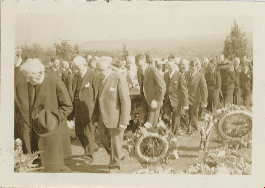
Pallbearers and procession in Masonic Cemetery
https://search.heritageburnaby.ca/link/museumdescription19460
- Repository
- Burnaby Village Museum
- Date
- 1937
- Collection/Fonds
- Hawkshaw family fonds
- Description Level
- Item
- Physical Description
- 1 photograph : sepia ; 6.5 x 9 cm
- Scope and Content
- Photograph of pallbearers and funeral procession in the Masonic Cemetery in Burnaby where Charles Woodward was laid to rest in the mausoleum of the Woodward family.
- Repository
- Burnaby Village Museum
- Collection/Fonds
- Hawkshaw family fonds
- Description Level
- Item
- Physical Description
- 1 photograph : sepia ; 6.5 x 9 cm
- Scope and Content
- Photograph of pallbearers and funeral procession in the Masonic Cemetery in Burnaby where Charles Woodward was laid to rest in the mausoleum of the Woodward family.
- Subjects
- Ceremonies - Funerals
- Accession Code
- BV996.6.166
- Access Restriction
- No restrictions
- Reproduction Restriction
- No known restrictions
- Date
- 1937
- Media Type
- Photograph
- Historic Neighbourhood
- Vancouver Heights (Historic Neighbourhood)
- Planning Study Area
- Willingdon Heights Area
- Scan Resolution
- 600
- Scan Date
- 2023-02-06
- Notes
- Title based on contents of photograph
- Caption on album page reads: "June 4 / 1937 / FURTHER ON"
- Photograph is part of photograph album BV996.6.1
Images
Pallbearers and procession in Masonic Cemetery
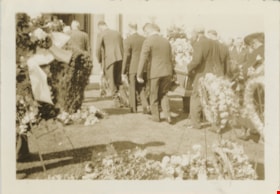
https://search.heritageburnaby.ca/link/museumdescription19461
- Repository
- Burnaby Village Museum
- Date
- 1937
- Collection/Fonds
- Hawkshaw family fonds
- Description Level
- Item
- Physical Description
- 1 photograph : sepia ; 6.5 x 9 cm
- Scope and Content
- Photograph of pallbearers and funeral procession in the Masonic Cemetery in Burnaby where Charles Woodward was laid to rest in the mausoleum of the Woodward family. The procession is leaving from the hearse into the cemetery.
- Repository
- Burnaby Village Museum
- Collection/Fonds
- Hawkshaw family fonds
- Description Level
- Item
- Physical Description
- 1 photograph : sepia ; 6.5 x 9 cm
- Scope and Content
- Photograph of pallbearers and funeral procession in the Masonic Cemetery in Burnaby where Charles Woodward was laid to rest in the mausoleum of the Woodward family. The procession is leaving from the hearse into the cemetery.
- Subjects
- Ceremonies - Funerals
- Accession Code
- BV996.6.167
- Access Restriction
- No restrictions
- Reproduction Restriction
- No known restrictions
- Date
- 1937
- Media Type
- Photograph
- Historic Neighbourhood
- Vancouver Heights (Historic Neighbourhood)
- Planning Study Area
- Willingdon Heights Area
- Scan Resolution
- 600
- Scan Date
- 2023-02-06
- Notes
- Title based on contents of photograph
- Caption on album page reads: "June 4 / 1937 / JUST LEAVING HEARSH"
- Photograph is part of photograph album BV996.6.1
Images

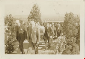
Pallbearers carrying coffin into mausoleum
https://search.heritageburnaby.ca/link/museumdescription19462
- Repository
- Burnaby Village Museum
- Date
- 1937
- Collection/Fonds
- Hawkshaw family fonds
- Description Level
- Item
- Physical Description
- 1 photograph : sepia ; 6.5 x 9 cm
- Scope and Content
- Photograph of pallbearers carrying the coffin of Charles Woodward into the Woodward family mausoleum inside the Masonic Cemetery in Burnaby.
- Repository
- Burnaby Village Museum
- Collection/Fonds
- Hawkshaw family fonds
- Description Level
- Item
- Physical Description
- 1 photograph : sepia ; 6.5 x 9 cm
- Scope and Content
- Photograph of pallbearers carrying the coffin of Charles Woodward into the Woodward family mausoleum inside the Masonic Cemetery in Burnaby.
- Subjects
- Ceremonies - Funerals
- Accession Code
- BV996.6.168
- Access Restriction
- No restrictions
- Reproduction Restriction
- No known restrictions
- Date
- 1937
- Media Type
- Photograph
- Historic Neighbourhood
- Vancouver Heights (Historic Neighbourhood)
- Planning Study Area
- Willingdon Heights Area
- Scan Resolution
- 600
- Scan Date
- 2023-02-06
- Notes
- Title based on contents of photograph
- Caption on album page reads: "June 4 / 1937 / Just before the Vault"
- Photograph is part of photograph album BV996.6.1
Images

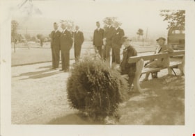
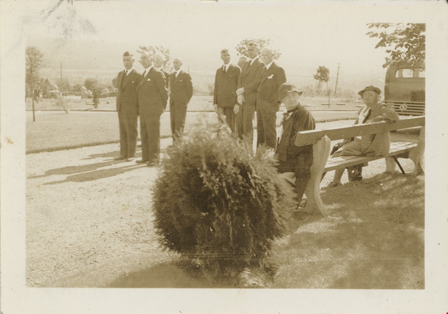
Pallbearers in Masonic Cemetery
https://search.heritageburnaby.ca/link/museumdescription19459
- Repository
- Burnaby Village Museum
- Date
- 7 Jun. 1937
- Collection/Fonds
- Hawkshaw family fonds
- Description Level
- Item
- Physical Description
- 1 photograph : sepia ; 6.5 x 9 cm
- Scope and Content
- Photograph of six pallbearers standing in the Masonic Cemetery in Burnaby where Charles Woodward was laid to rest in the mausoleum of the Woodward family. Two women are seated on a bench.
- Repository
- Burnaby Village Museum
- Collection/Fonds
- Hawkshaw family fonds
- Description Level
- Item
- Physical Description
- 1 photograph : sepia ; 6.5 x 9 cm
- Scope and Content
- Photograph of six pallbearers standing in the Masonic Cemetery in Burnaby where Charles Woodward was laid to rest in the mausoleum of the Woodward family. Two women are seated on a bench.
- Subjects
- Ceremonies - Funerals
- Accession Code
- BV996.6.165
- Access Restriction
- No restrictions
- Reproduction Restriction
- No known restrictions
- Date
- 7 Jun. 1937
- Media Type
- Photograph
- Historic Neighbourhood
- Vancouver Heights (Historic Neighbourhood)
- Planning Study Area
- Willingdon Heights Area
- Scan Resolution
- 600
- Scan Date
- 2023-02-06
- Notes
- Title based on contents of photograph
- Caption on album page reads: "June 4 / 1937 / PALL BEARES"
- Photograph is part of photograph album BV996.6.1
Images
![Paved road, [1948] thumbnail](/media/hpo/_Data/_BVM_Images/1971/1971_0012_0087_001.jpg?width=280)
Paved road
https://search.heritageburnaby.ca/link/museumdescription19
- Repository
- Burnaby Village Museum
- Date
- [1948]
- Collection/Fonds
- Burnaby Village Museum Photograph collection
- Description Level
- Item
- Physical Description
- 1 photograph : sepia ; 6.8 x 11.4 cm
- Scope and Content
- Photograph of a paved road running through a cleared lot. There is an electric post on the roadside, and woods in the background. Catalogue information from 1976 indicates that it is a street development in Burnaby, ca. 1948. This may be the site of the Willingdon Heights subdivision. Annotation o…
- Repository
- Burnaby Village Museum
- Collection/Fonds
- Burnaby Village Museum Photograph collection
- Description Level
- Item
- Physical Description
- 1 photograph : sepia ; 6.8 x 11.4 cm
- Scope and Content
- Photograph of a paved road running through a cleared lot. There is an electric post on the roadside, and woods in the background. Catalogue information from 1976 indicates that it is a street development in Burnaby, ca. 1948. This may be the site of the Willingdon Heights subdivision. Annotation on lower right front of photograph: "26." Stamped on back of photograph: "321X."
- Subjects
- Geographic Features - Roads
- Land Clearing
- Names
- Bingham, Alfred "Alf"
- Accession Code
- HV971.12.87
- Access Restriction
- No restrictions
- Reproduction Restriction
- No known restrictions
- Date
- [1948]
- Media Type
- Photograph
- Historic Neighbourhood
- Vancouver Heights (Historic Neighbourhood)
- Planning Study Area
- Willingdon Heights Area
- Scan Resolution
- 600
- Scan Date
- 2023-03-21
- Notes
- Title based on contents of photograph
Images
![Paved road, [1948] thumbnail](/media/hpo/_Data/_BVM_Images/1971/1971_0012_0087_001.jpg)