Narrow Results By
Subject
- Advertising Medium 3
- Advertising Medium - Business Cards 3
- Advertising Medium - Signs and Signboards 1
- Buildings - Commercial - Bakeries 3
- Buildings - Commercial - Stores 1
- Buildings - Religious - Churches 1
- Buildings - Schools 2
- Businesses 4
- Businesses - Real Estate Agencies 1
- Clothing 1
- Documentary Artifacts 1
- Documentary Artifacts - Booklets 2
advertisement; blotter
https://search.heritageburnaby.ca/link/museumartifact40410
- Repository
- Burnaby Village Museum
- Accession Code
- BV985.5851.1
- Description
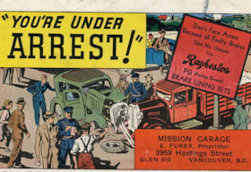
- Mission Garage - Advertisement Blotter. Advertisment card for the Mission Garage at 3959 Hastings Street Vancouver, run by E. Furer. (Although the address on the card says Vancouver, it is actually in Burnaby, part of the Vancouver Heights community.) The front of the card has an illustration of an automobile accident. There is a caption at the top of the card "You're Under Arrest!" and another caption on the side of the card "Don't Face Arrest Because of Faulty Brakes...". The reverse side of the card has pink construction paper which has been used as an ink blotter.
- Subjects
- Written Communication Tools and Equipment
- Written Communication Tools and Equipment - Blotter
- Advertising Medium
- Advertising Medium - Business Cards
- Historic Neighbourhood
- Vancouver Heights (Historic Neighbourhood)
Images
advertisement; blotter
https://search.heritageburnaby.ca/link/museumartifact40411
- Repository
- Burnaby Village Museum
- Accession Code
- BV985.5852.1
- Description
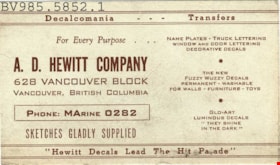
- A.D. Hewitt Company - Advertisment Blotter. Advertisement card for A.D.Hewitt Company, a decal company in Vancouver BC. The card promotes Name Plates, Truck Lettering, Window and Door Lettering among other serives. The back of the card has been used as an ink blotter.
- Subjects
- Written Communication Tools and Equipment
- Written Communication Tools and Equipment - Blotter
- Advertising Medium
- Advertising Medium - Business Cards
- Historic Neighbourhood
- Vancouver Heights (Historic Neighbourhood)
Images
advertisement; blotter
https://search.heritageburnaby.ca/link/museumartifact40412
- Repository
- Burnaby Village Museum
- Accession Code
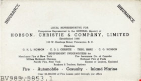
- BV985.5853.1
- Description
- Hobson, Christie & Company - Advertisement Blotter. Advertisement card for Hobson, Christie & Company Limited Insurance at 163 W.Hastings Street Vancouver. The company supplies insurance for fire, automobile, casualty and inland marine. The back side of the card has been used as an ink blotter.
- Subjects
- Written Communication Tools and Equipment
- Written Communication Tools and Equipment - Blotter
- Advertising Medium
- Advertising Medium - Business Cards
- Historic Neighbourhood
- Vancouver Heights (Historic Neighbourhood)
Images

![Bird's eye view of New Westminster, Burnaby and Vancouver, [ca. 1911] thumbnail](/media/hpo/_Data/_BVM_Cartographic_Material/1983/1983_0012_0001_002%20Web.jpg?width=280)
Bird's eye view of New Westminster, Burnaby and Vancouver
https://search.heritageburnaby.ca/link/museumdescription8199
- Repository
- Burnaby Village Museum
- Date
- [ca. 1911]
- Collection/Fonds
- Burnaby Village Museum Map collection
- Description Level
- Item
- Physical Description
- 1 map : hand painted ; 65.5 x 99 cm
- Scope and Content
- An untitled monochromatic grayscale map of a developer's bird's eye view looking north west from Burnaby Mountain. View includes Burnaby, New Westminster, Vancouver with the North shore in the distance. Burnaby neighbourhood subdivisions of "Burnaby Heights" and "Buena Vista" are featured near the…
- Repository
- Burnaby Village Museum
- Collection/Fonds
- Burnaby Village Museum Map collection
- Description Level
- Item
- Physical Description
- 1 map : hand painted ; 65.5 x 99 cm
- Scope and Content
- An untitled monochromatic grayscale map of a developer's bird's eye view looking north west from Burnaby Mountain. View includes Burnaby, New Westminster, Vancouver with the North shore in the distance. Burnaby neighbourhood subdivisions of "Burnaby Heights" and "Buena Vista" are featured near the centre of the map. These neighbourhood subdivisions were marketed by Real Estate Agents Liebly & Blumer in 1911. Roads, buildings, factories, railways and bridges are identified on the map.
- Subjects
- Businesses - Real Estate Agencies
- Responsibility
- Leibly & Blumer Realty Co. Incorporated
- Accession Code
- HV983.12.1
- Access Restriction
- No restrictions
- Reproduction Restriction
- No known restrictions
- Date
- [ca. 1911]
- Media Type
- Cartographic Material
- Historic Neighbourhood
- East Burnaby (Historic Neighbourhood)
- Vancouver Heights (Historic Neighbourhood)
- Planning Study Area
- Cariboo-Armstrong Area
- Burnaby Heights Area
- Scan Resolution
- 300
- Scan Date
- December 2020
- Scale
- 100
- Notes
- Title based on contents of map
- Note in pencil on verso of photograph reads: "Make tint block of Buena Vista / Blocks only as shown in lots"
Zoomable Images
![Bird's eye view of New Westminster, Burnaby and Vancouver, [ca. 1911] thumbnail](/media/hpo/_Data/_BVM_Cartographic_Material/1983/1983_0012_0001_001_seadragon/1983_0012_0001_001.jpg?w=280)
booklet
https://search.heritageburnaby.ca/link/museumartifact90322
- Repository
- Burnaby Village Museum
- Accession Code
- BV020.8.3
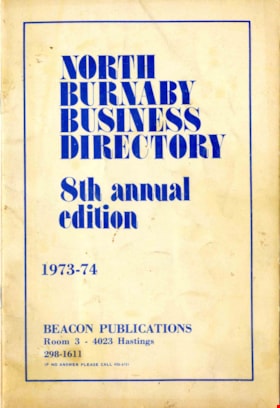
- Description
- Booklet; business directory; thin card cover secured to single signature with two metal staples; 16 pages (double sided) printed on newsprint; Front cover reads: "North Burnaby / Business / Directory / 8th annual edition / 1973-74" / "Beacon Publications / Room 3 - 4023 Hastings / 298-1611" First page includes a list of "Important / Telephone Numbers" handwritten names and numbers added in ink and pencil
- Object History
- Donor's family lived in North Burnaby. Business directory was probably provided to all residents who lived in this neighbourhood of Burnaby.
- Category
- 08. Communication Artifacts
- Classification
- Documentary Artifacts - - Other Documents
- Object Term
- Book
- Marks/Labels
- Beacon Publications Room 3 - 4023 Hastings 298-1611
- Measurements
- 23 x 15 cm
- Maker
- Beacon Publications
- Country Made
- Canada
- Province Made
- British Columbia
- Site/City Made
- Burnaby
- Publication Date
- [1974]
- Historic Neighbourhood
- Vancouver Heights (Historic Neighbourhood)
- Planning Study Area
- Burnaby Heights Area
Images

booklet
https://search.heritageburnaby.ca/link/museumartifact90323
- Repository
- Burnaby Village Museum
- Accession Code
- BV020.8.11
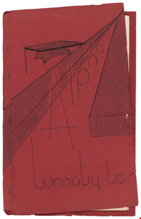
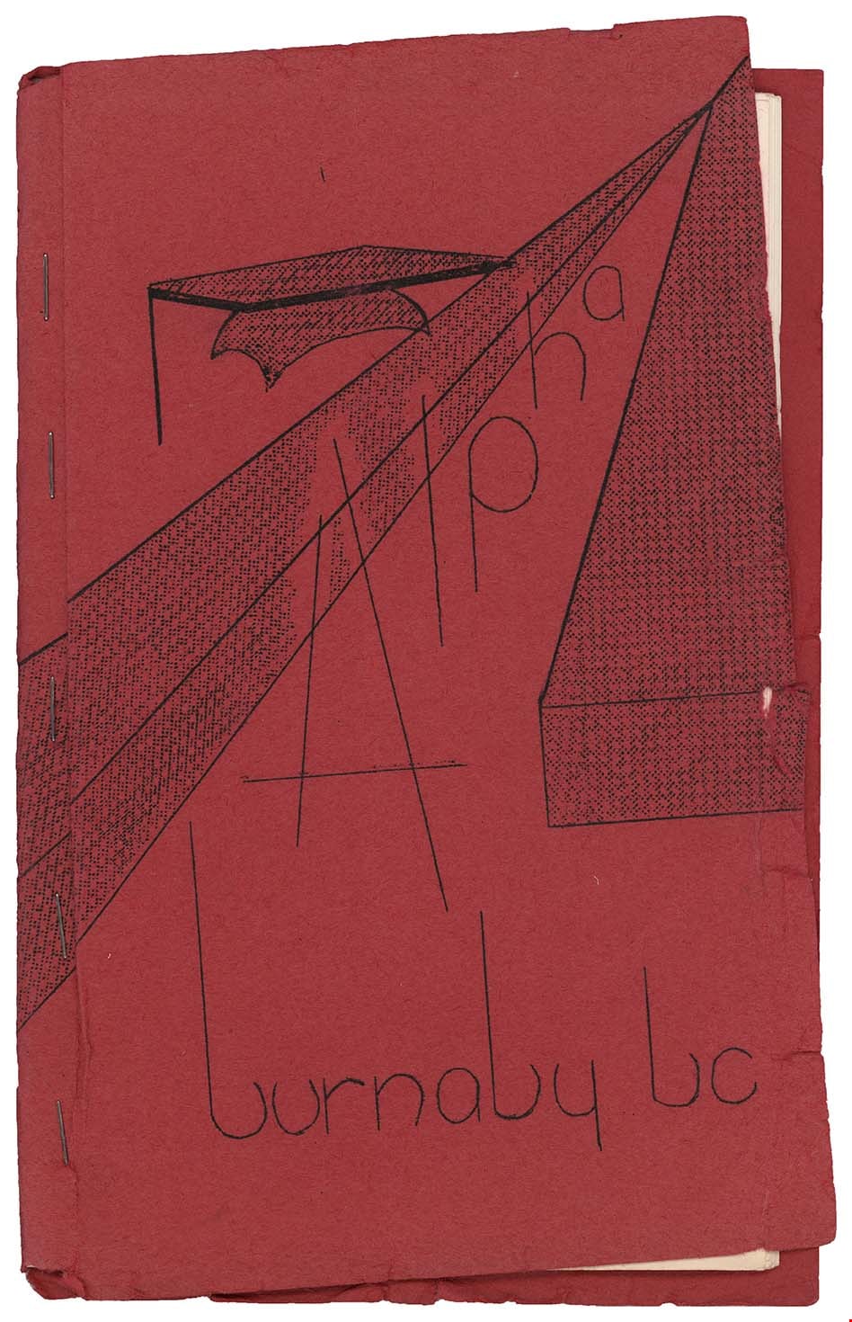
- Description
- Booklet; school handbook; red paper cover folded around 17 typewritten pages of cartridge paper with 5 metal staples; front cover reads "Alpha / burnaby bc". Second page inside reads: "Alpha / Junior Secondary / School / Handbook". Includes index on page 5; pages numbered 5 to 29; pull out floor plan of "Alpha Junior Secondary School" on blue paper in back of booklet. Handwritten annotations on first page
- Object History
- Donor attended Alpha Junior Secondary School.
- Category
- 08. Communication Artifacts
- Classification
- Documentary Artifacts - - Other Documents
- Object Term
- Book, Instruction
- Marks/Labels
- Alpha Junior Secondary School
- Measurements
- 23 x 15 cm
- Country Made
- Canada
- Province Made
- British Columbia
- Site/City Made
- Burnaby
- Title
- Alpha burnaby bc
- Publication Date
- [c. 1956]
- Names
- Alpha Secondary School
- Historic Neighbourhood
- Vancouver Heights (Historic Neighbourhood)
- Planning Study Area
- Burnaby Heights Area
Images
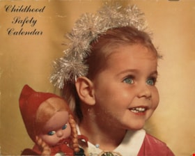
Calendar
https://search.heritageburnaby.ca/link/museumartifact90316
- Repository
- Burnaby Village Museum
- Accession Code
- BV020.8.14
- Description
- A Childhood Safety Calendar from Helen's Children's Wear from 1966. The front page of the calendar has a airbrushed image of a small girl smiling with blue eyes. She has a headband with silver pom-poms. She is holding a doll with a red hat and braids. The first two pages of the calendar are entitled "Children's Safety Diary. Each month of the calendar has a different image of a child. The back page has a reading entitled "Safety: Your Child's Most Important Lesson!"
- Object History
- Helen's Children's Wear was a popular and well known shop in Burnaby
- Helen's Children's Wear was located at 4142 Hastings Street. Owner Helen Arnold opened the store on East Hastings Street in 1948. She moved to the 4142 Hastings Street location in 1955, and added a landmark neon sign to the building in 1956. The sign featured a girl on a swing, and served as an important landmark in the neighbourhood. The store closed in 2007.
- Category
- 08. Communication Artifacts
- Classification
- Documentary Artifacts - - Other Documents
- Object Term
- Calendar
- Marks/Labels
- Helen's Children's Wear Specializing in Brand Name Merchandise 4142 E Hastings Street, North Burnaby, BC
- Measurements
- 21 cm l x 17cm h
- Country Made
- United States of America
- Title
- Childhood Safety Calendar
- Publication Date
- 1966
- Historic Neighbourhood
- Vancouver Heights (Historic Neighbourhood)
- Planning Study Area
- Burnaby Heights Area
Images
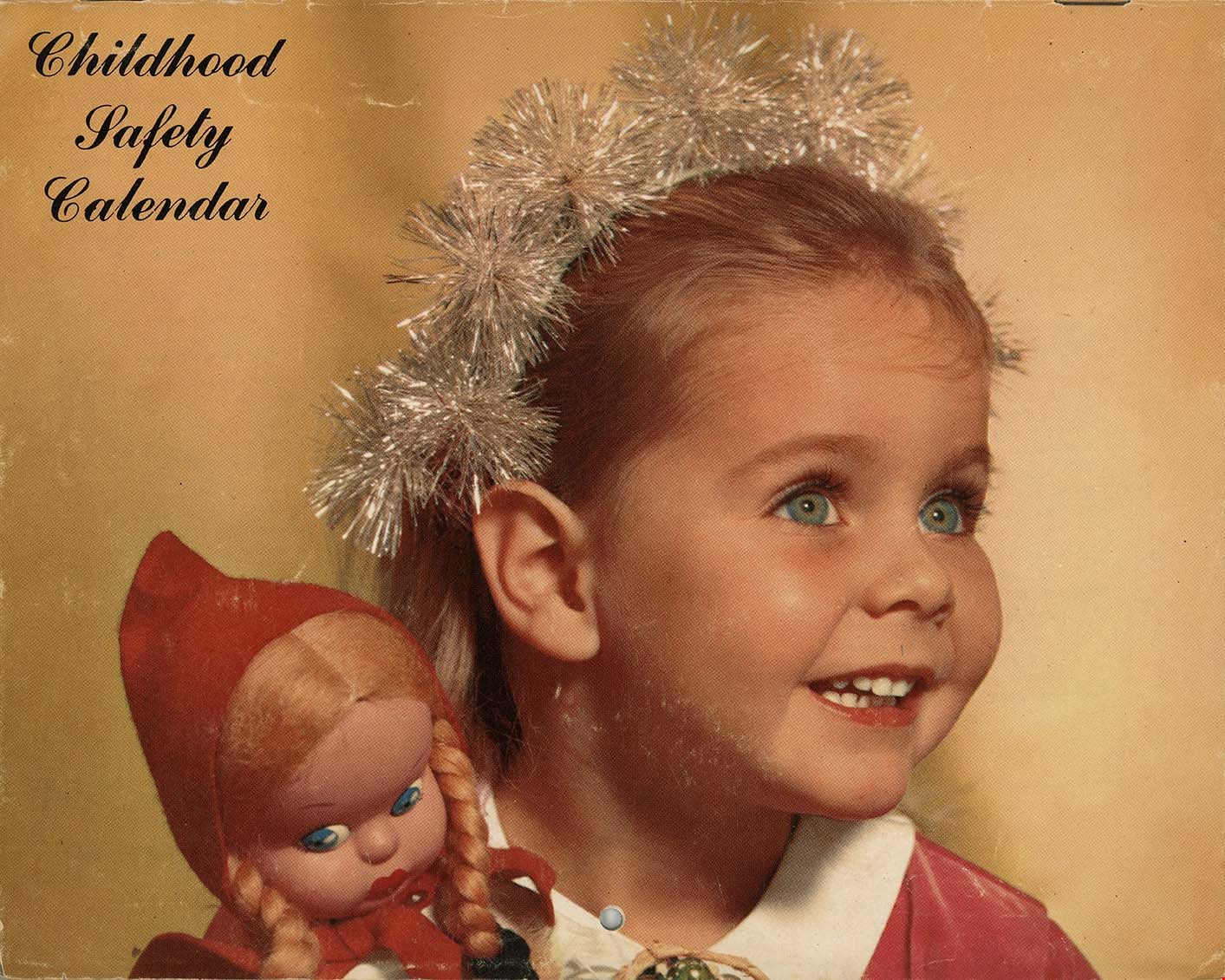
camera
https://search.heritageburnaby.ca/link/museumartifact91515
- Repository
- Burnaby Village Museum
- Accession Code
- BV021.28.1
- Description
- A Kodak camera inside of a brown leather camera case with a long shoulder strap. The camera case opens with a round metal clasp at the front top-centre. The rectangular camera fits snugly inside the case.
- Object History
- This camera belonged to Percy Mallett who immigrated to Okotoks, Alberta from Cornwall, England. He married Alice Mallett (nee Lowry) and moved to Vancouver, BC in 1910. The couple later moved to Burnaby to raise their family in 1915. They had three children.
- Classification
- Photographic T&E - - Camera Equipment
- Object Term
- Camera
- Marks/Labels
- Kodak
- Colour
- Brown
- Measurements
- height: 24 cm width: 13 cm depth: 5.5 cm
- Names
- Mallett, Percy
- Historic Neighbourhood
- Vancouver Heights (Historic Neighbourhood)
- Planning Study Area
- Burnaby Heights Area
Images

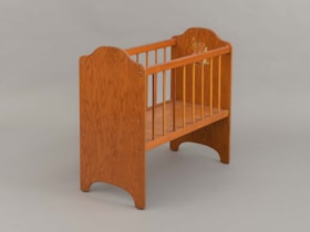
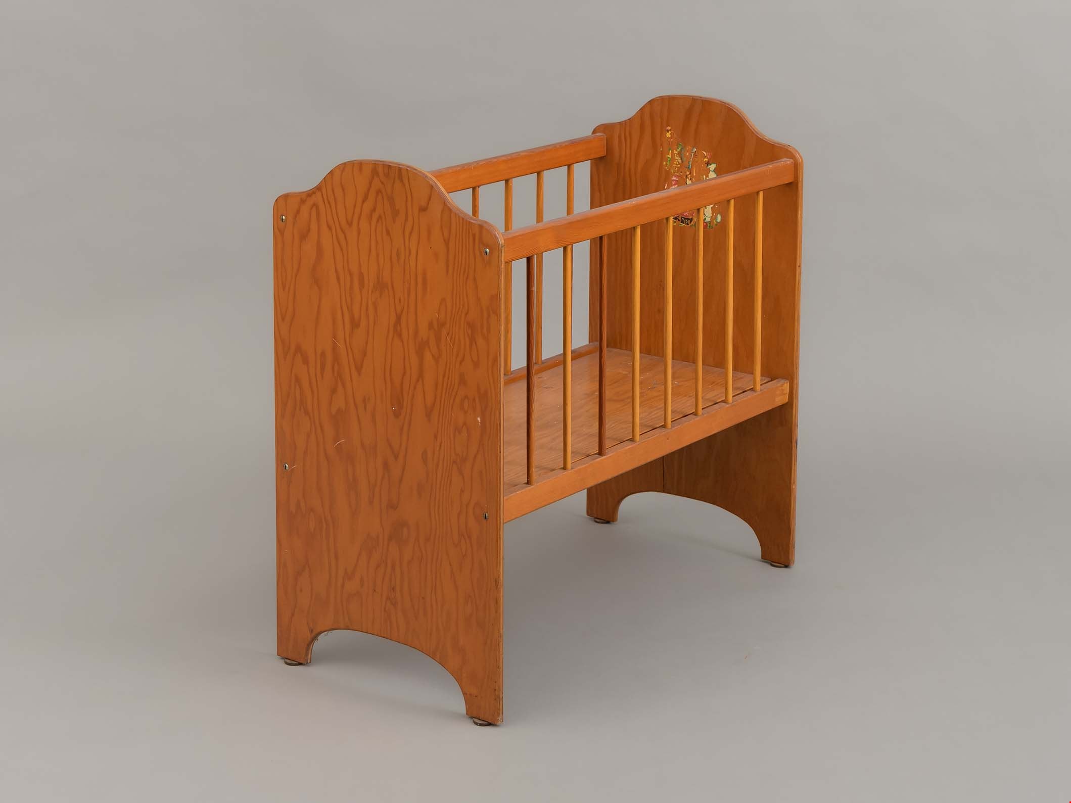
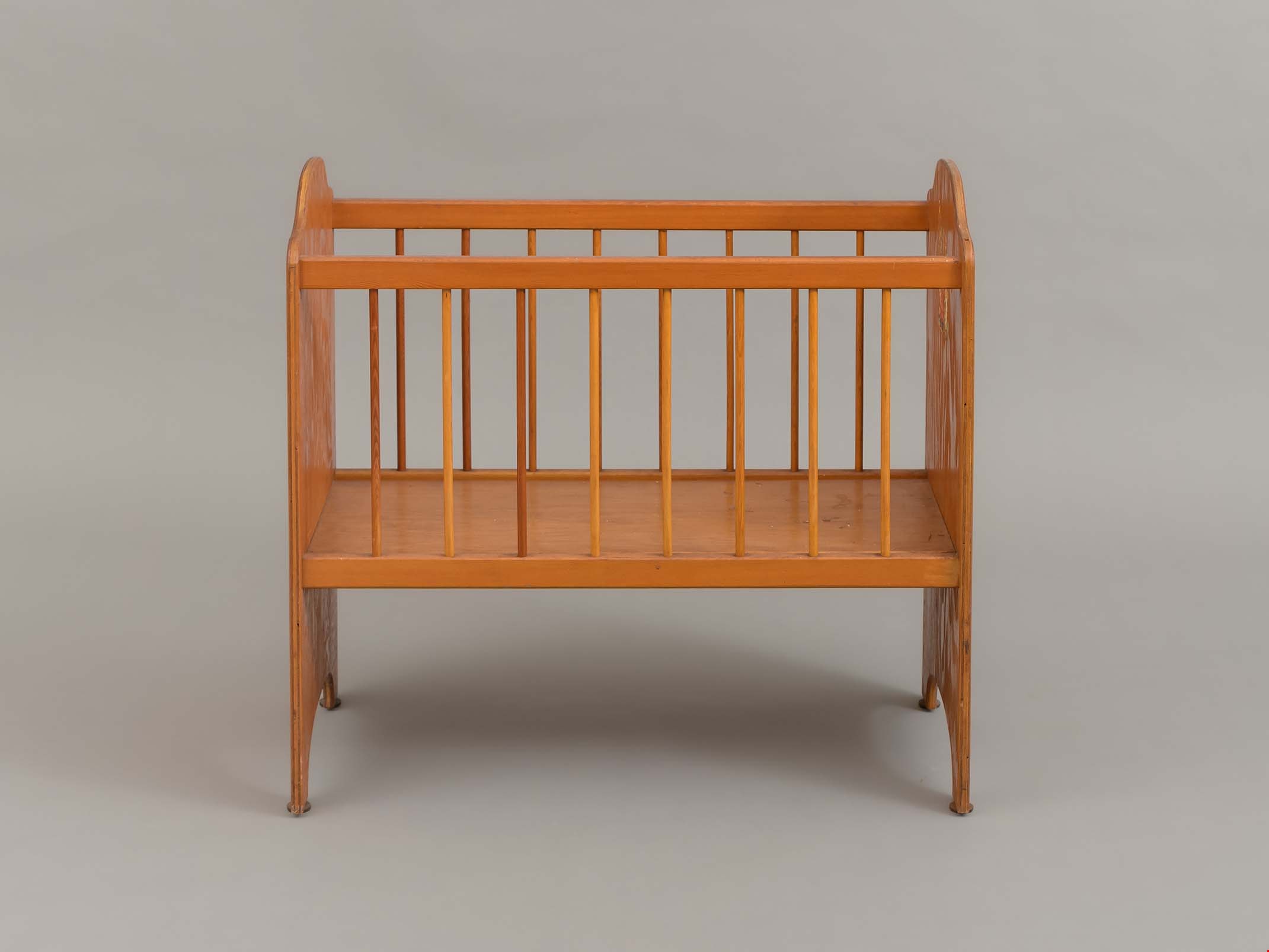
doll crib
https://search.heritageburnaby.ca/link/museumartifact83508
- Repository
- Burnaby Village Museum
- Accession Code
- BV013.21.4
- Description
- Doll Crib - The doll crib is large. The solid ends and bottom are made from 3/8 " plywood. The sides are eight, 3/8 ' dowels set in an upper and lower rail. The whole is screwed and glued together. There is the remains of a decal on the inside face of one end panel. The wood has been finished with a yellowed shelac or varnish.
- Object History
- Donor states that the object was one of a pair of doll beds made by Ed Simpson for the donor and her sister. Mr Simpson was a carpenter who was a member of the Longshoreman's union.
- Category
- 09. Recreational Artifacts
- Classification
- Toys
- Object Term
- Doll Accessory
- Measurements
- L: 71.0 cm W: 35.5 cm H: 66.5 cm
- Subjects
- Toys
- Historic Neighbourhood
- Vancouver Heights (Historic Neighbourhood)
- Planning Study Area
- Burnaby Heights Area
Images
Fire insurance plans - Greater Vancouver - Volume XV - Municipality of Burnaby
https://search.heritageburnaby.ca/link/museumdescription17795
- Repository
- Burnaby Village Museum
- Date
- 1927-1940
- Collection/Fonds
- Burnaby Village Museum Map collection
- Description Level
- Item
- Physical Description
- 11 plans on 8 sheets : col. lithographic print ; 64 x 54 cm
- Scope and Content
- Item consists of fire insurance plans titled "Greater Vancouver / Volume XV / Municipality / of Burnaby" surveyed May 1927 and revised October 1940. Volume XV includes a two page Key Plan (A and B) identifying associated plan numbers and district lots and nine numbered fire insurance plans identifi…
- Repository
- Burnaby Village Museum
- Collection/Fonds
- Burnaby Village Museum Map collection
- Description Level
- Item
- Physical Description
- 11 plans on 8 sheets : col. lithographic print ; 64 x 54 cm
- Material Details
- Scales between [1:600] and [1:6000]
- Scope and Content
- Item consists of fire insurance plans titled "Greater Vancouver / Volume XV / Municipality / of Burnaby" surveyed May 1927 and revised October 1940. Volume XV includes a two page Key Plan (A and B) identifying associated plan numbers and district lots and nine numbered fire insurance plans identified as; 1507; 1508 ; 1517; 1518; 1519; 1520;1521; 1531and 1532.
- Publisher
- Plan Department of Fire Branch of British Columbia Underwriters' Association
- Accession Code
- BV987.1.70
- Access Restriction
- No restrictions
- Reproduction Restriction
- May be restricted by third party rights
- Date
- 1927-1940
- Media Type
- Cartographic Material
- Historic Neighbourhood
- Vancouver Heights (Historic Neighbourhood)
- Planning Study Area
- Burnaby Heights Area
- Willingdon Heights Area
- Scan Resolution
- 400
- Notes
- Title based on contents of item
- These plans are contained within a bound book with labels on cover page reading: "Plan No. 90 / THIS INSURANCE PLAN / of / Vancouver VOLUME "8" / IN THE PROPERTY OF THE / British Columbia Insurance Underwriter's Association / Vancouver B.C. / AND IS LOANED / MELVILLE F. THOMSON CO. .../ Date May 26th, 1934"; / "Plan No. 74 / THIS INSURANCE PLAN / OF / VANCOUVER VOLUME "9"" / Plan No. 11 / THIS INSURANCE PLAN / OF / BURNABY VOLUMES 15-19" / "THIS PLAN IS THE PROPERTY OF / THE / BRITISH LAW INSURANCE COMPANY / LIMITED"
- Fire insurance plans cover various district lots in Burnaby including: District Lot 116,121, 186 and 187.
- Sticker adhered to Key Plan B reads: "
- Contact Burnaby Village Museum to view fire insurance plans that are part of Volume XV
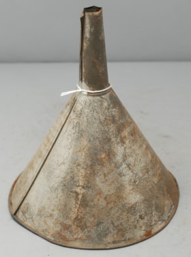
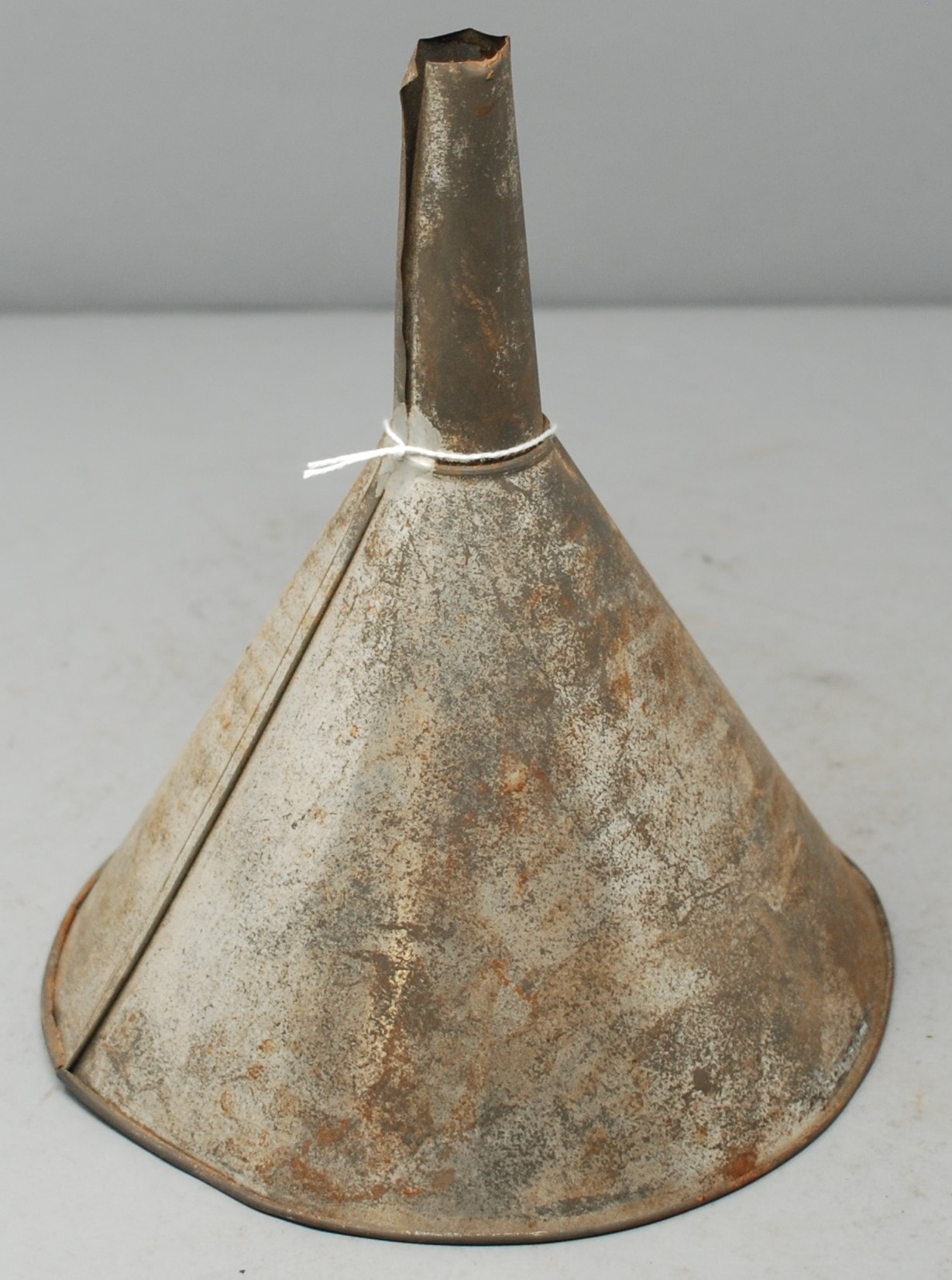
funnel
https://search.heritageburnaby.ca/link/museumartifact89581
- Repository
- Burnaby Village Museum
- Accession Code
- BV018.31.12
- Description
- funnel; metal funnel; conical bowl, with narrow neck.
- Object History
- Object was used by donor at Valley Bakery. Currently located at 4058 East Hastings Street, Valley Bakery opened in Burnaby in 1957 and is still owned and operated by the same family as of 2019.
- Category
- 04.Tools & Equipment for Materials
- Object Term
- Funnel
- Measurements
- L: 21.0 cm Dia.: 18.8 cm
- Names
- Valley Bakery
- Historic Neighbourhood
- Vancouver Heights (Historic Neighbourhood)
- Planning Study Area
- Burnaby Heights Area
Images

Gilmour Avenue School site
https://search.heritageburnaby.ca/link/museumdescription11129
- Repository
- Burnaby Village Museum
- Date
- May 27, 1915
- Collection/Fonds
- Ronald G. Scobbie collection
- Description Level
- Item
- Physical Description
- 1 survey plan : blueprint on paper ; 56 x 54 cm
- Scope and Content
- Survey plan of Gilmore Avenue School site. Title on plan reads: "Gilmour Avenue School Site / Burnaby Municipality / Being Lots 1-10 inc. & Lots 27-36 inc. of Block 9 / of Subdivision of a Portion of Lot 187, GP.1 / New Westminster District". "Note. School site is as shown below, the original...am…
- Repository
- Burnaby Village Museum
- Collection/Fonds
- Ronald G. Scobbie collection
- Description Level
- Item
- Physical Description
- 1 survey plan : blueprint on paper ; 56 x 54 cm
- Material Details
- Scale: 40 feet = 1 inch
- Scope and Content
- Survey plan of Gilmore Avenue School site. Title on plan reads: "Gilmour Avenue School Site / Burnaby Municipality / Being Lots 1-10 inc. & Lots 27-36 inc. of Block 9 / of Subdivision of a Portion of Lot 187, GP.1 / New Westminster District". "Note. School site is as shown below, the original...amended" "by cancelling Lots 1-10 & 27-30 inc....order of court filed No.4938".
- History
- The school was named after Hugh B. Gilmour, but an error by a municipal clerk in the Street Naming Bylaw in 1912 (Bylaw Number 135) changed the spelling to "Gilmore" Avenue and the school name was spelled "Gilmore" Avenue School hereafter.
- Creator
- McGugan, Donald Johnston
- Subjects
- Buildings - Schools
- Names
- Gilmore Avenue School
- Responsibility
- Burnett & McGugan, Engineers and Surveyors
- Geographic Access
- Gilmore Avenue
- Accession Code
- BV003.83.8
- Access Restriction
- No restrictions
- Reproduction Restriction
- No known restrictions
- Date
- May 27, 1915
- Media Type
- Cartographic Material
- Historic Neighbourhood
- Vancouver Heights (Historic Neighbourhood)
- Planning Study Area
- Willingdon Heights Area
- Scan Resolution
- 440
- Scan Date
- 22-Dec-2020
- Scale
- 100
- Notes
- Transcribed title taken from plan
- Oath in bottom left corner reads: "I, D.J. McGugan...did superintend the survey", "...completed on the 27th day of May 1915" and noterized by Walter Edmonds" "sworn...29th Day of May 1915"; "Burnett and McGugan. B.C. Land Surveyors Etc. New Westminster. B.C."
- Note in black ink on verso of plan reads: "1782"
Zoomable Images


hair brush
https://search.heritageburnaby.ca/link/museumartifact17379
- Repository
- Burnaby Village Museum
- Accession Code
- HV979.50.6
- Description
- Hair brush, wooden back and handle; back has raised spine down middle, hollow either side; light wood with dark patches; nine white inlaid dots at one end of handle; "WARRANTED SECURE SOLID BACK"; short stiff bristles, blond
- Object History
- This item belonged to the owner of Stewart's Cartage & Fuel Supply (1910-1978) on 3870 East Hastings and lived at 3902 Albert Street, Burnaby. He was involved in local politics in Burnaby North, as well as the North Burnaby Board of Trade and the Joint Community Ratepayers Association.
- Category
- 03. Personal Artifacts
- Classification
- Toilet Articles - - Hair Care Artifacts
- Object Term
- Hairbrush
- Subjects
- Personal Gear
- Historic Neighbourhood
- Vancouver Heights (Historic Neighbourhood)
- Planning Study Area
- Burnaby Heights Area
Images


Municipality of Burnaby - Volume XV and Volume XVIII
https://search.heritageburnaby.ca/link/museumdescription8680
- Repository
- Burnaby Village Museum
- Date
- May 1927
- Collection/Fonds
- Burnaby Village Museum Map collection
- Description Level
- File
- Physical Description
- 4 plans on 4 sheets : col. lithographic prints ; 63.5 x 53.5 cm folded to 53 x 31.5 cm
- Scope and Content
- File consists of four pages of plans removed from a bound book containing a series of fire insurance plans of the Municipality of Burnaby. The first two pages are numbered "A" and "B" and are key plans from "GREATER VANCOUVER B.C. / VOLUME XV / Surveyed _ May 1927 / MUNICIPALITY OF / BURNABY", "PLA…
- Repository
- Burnaby Village Museum
- Collection/Fonds
- Burnaby Village Museum Map collection
- Description Level
- File
- Physical Description
- 4 plans on 4 sheets : col. lithographic prints ; 63.5 x 53.5 cm folded to 53 x 31.5 cm
- Material Details
- Scales [1:1200] and [1:6000]
- Scope and Content
- File consists of four pages of plans removed from a bound book containing a series of fire insurance plans of the Municipality of Burnaby. The first two pages are numbered "A" and "B" and are key plans from "GREATER VANCOUVER B.C. / VOLUME XV / Surveyed _ May 1927 / MUNICIPALITY OF / BURNABY", "PLAN DEPT. FIRE BRANCH _ B.C. INSURANCE UNDERWRITERS ASSN.". Key Plan "B" covers plans: 1505; 1506; 1512 to 1516; 1540 to 1544; 1550 to 1557 and District Lots: 129 to 132; 135 to 138; 205 to 208 and 215 to 218. Key Plan "A" covers plans: 1501 to 1504; 1507 to 1511; 1517 to 1525; 1531 to 1539; 1545 to 1550 and District Lots: 116 to 127 and 186 to 189. Plan "1806" is part of "GREATER VANCOUVER B.C. / VOLUME XVIII / Municipality of Burnaby / May, 1927" and covers District Lot 153. Plan "1807" is from "GREATER VANCOUVER B.C. / VOLUME XVIII / Municipality of Burnaby / May, 1927" and covers District Lots: 99,149 and 152.
- Responsibility
- British Columbia Underwriters' Association
- Accession Code
- HV972.111.2
- Access Restriction
- No restrictions
- Reproduction Restriction
- May be restricted by third party rights
- Date
- May 1927
- Media Type
- Cartographic Material
- Historic Neighbourhood
- Vancouver Heights (Historic Neighbourhood)
- Lochdale (Historic Neighbourhood)
- Capitol Hill (Historic Neighbourhood)
- Central Park (Historic Neighbourhood)
- Alta Vista (Historic Neighbourhood)
- Planning Study Area
- Burnaby Heights Area
- Sperling-Broadway Area
- Lochdale Area
- Parkcrest-Aubrey Area
- Westridge Area
- Willingdon Heights Area
- Capitol Hill Area
- Maywood Area
- Marlborough Area
- Scan Resolution
- 400
- Scan Date
- 2021-11-18
- Notes
- Title based on content of plans
- Scales are measured 1 inch = 100 feet and 1 inch = 500 feet
- See also BV987.1.70d for revised versions of plans
Zoomable Images


Municipality of Burnaby - Volume XV and Volume XVIII
https://search.heritageburnaby.ca/link/museumdescription8681
- Repository
- Burnaby Village Museum
- Date
- May 1927
- Collection/Fonds
- Burnaby Village Museum Map collection
- Description Level
- File
- Physical Description
- 4 plans on 4 sheets : col. lithographic prints, ms. annotations in blue ink ; 63.5 x 53.5 cm folded to 53 x 31.5 cm
- Scope and Content
- File consists of four pages of plans removed from a bound book containing a series of fire insurance plans of the Municipality of Burnaby. Plan "1507" and plan "1517" are from "GREATER VANCOUVER B.C. / VOLUME XV / Municipality of Burnaby / May, 1927". Plan "1507" covers District Lot 186 and plan "1…
- Repository
- Burnaby Village Museum
- Collection/Fonds
- Burnaby Village Museum Map collection
- Description Level
- File
- Physical Description
- 4 plans on 4 sheets : col. lithographic prints, ms. annotations in blue ink ; 63.5 x 53.5 cm folded to 53 x 31.5 cm
- Material Details
- Scale [1:600] and [1:1200]
- Scope and Content
- File consists of four pages of plans removed from a bound book containing a series of fire insurance plans of the Municipality of Burnaby. Plan "1507" and plan "1517" are from "GREATER VANCOUVER B.C. / VOLUME XV / Municipality of Burnaby / May, 1927". Plan "1507" covers District Lot 186 and plan "1517" covers District Lot 116. Plan "1804" and plan "1805" are from "GREATER VANCOUVER B.C. / VOLUME XVIII / Municipality of Burnaby / May, 1927". Plans "1804" and "1805" cover District Lot 153.
- Responsibility
- British Columbia Underwriters' Association
- Accession Code
- HV972.111.3
- Access Restriction
- No restrictions
- Reproduction Restriction
- May be restricted by third party rights
- Date
- May 1927
- Media Type
- Cartographic Material
- Historic Neighbourhood
- Central Park (Historic Neighbourhood)
- Vancouver Heights (Historic Neighbourhood)
- Planning Study Area
- Maywood Area
- Willingdon Heights Area
- Scan Resolution
- 400
- Scan Date
- 2021-11-18
- Notes
- Title based on content of plans
- See also BV987.1.70d for revised versions of plans
- Scale is measured 1 inch = 100 feet
Images


![Municipality of Burnaby - Volume XV and Volume XVIII, 1927-[1940] thumbnail](/media/hpo/_Data/_BVM_Artifacts/1972/1972_0111_0004_003.jpg?width=280)
Municipality of Burnaby - Volume XV and Volume XVIII
https://search.heritageburnaby.ca/link/museumdescription8682
- Repository
- Burnaby Village Museum
- Date
- 1927-[1940]
- Collection/Fonds
- Burnaby Village Museum Map collection
- Description Level
- File
- Physical Description
- 4 plans on 4 sheets: col. lithographic prints ; 63.5 x 53.5 cm folded to 53 x 31.5 cm
- Scope and Content
- File consists of four pages of plans removed from a bound book containing a series of fire insurance plans of the Municipality of Burnaby. Plan "1518" and "1519" are from "GREATER VANCOUVER B.C. / VOLUME XV / Municipality of Burnaby / May, 1927". Plan "1518" covers District Lot 116 and Plan "1519"…
- Repository
- Burnaby Village Museum
- Collection/Fonds
- Burnaby Village Museum Map collection
- Description Level
- File
- Physical Description
- 4 plans on 4 sheets: col. lithographic prints ; 63.5 x 53.5 cm folded to 53 x 31.5 cm
- Material Details
- Scale [1:600]
- Scope and Content
- File consists of four pages of plans removed from a bound book containing a series of fire insurance plans of the Municipality of Burnaby. Plan "1518" and "1519" are from "GREATER VANCOUVER B.C. / VOLUME XV / Municipality of Burnaby / May, 1927". Plan "1518" covers District Lot 116 and Plan "1519" covers District Lot 121. Plan "1802" and plan "1803" are from "GREATER VANCOUVER B.C. / VOLUME XVIII / Municipality of Burnaby / May, 1927". Both plans "1802" and "1803" cover District Lot 153.
- Responsibility
- British Columbia Underwriters' Association
- Accession Code
- HV972.111.4
- Access Restriction
- No restrictions
- Reproduction Restriction
- May be restricted by third party rights
- Date
- 1927-[1940]
- Media Type
- Cartographic Material
- Historic Neighbourhood
- Vancouver Heights (Historic Neighbourhood)
- Central Park (Historic Neighbourhood)
- Planning Study Area
- Willingdon Heights Area
- Marlborough Area
- Scan Resolution
- 400
- Scan Date
- 2021-11-18
- Notes
- Title based on content of plans
- See also BV987.1.70d for revised versions of plans
- Scale is measured 1 inch = 50 feet
- Contact Burnaby Village Museum to access plans 1518 and 1519 (these plans have revisions on top - date of revisions is uncertain)
Images
![Municipality of Burnaby - Volume XV and Volume XVIII, 1927-[1940] thumbnail](/media/hpo/_Data/_BVM_Artifacts/1972/1972_0111_0004_003.jpg)


Municipality of Burnaby- Volume XV and Volume XVIII
https://search.heritageburnaby.ca/link/museumdescription8686
- Repository
- Burnaby Village Museum
- Date
- May 1927
- Collection/Fonds
- Burnaby Village Museum Map collection
- Description Level
- File
- Physical Description
- 4 plans on 4 sheets : col. lithographic prints ; 63.5 x 53.5 cm folded to 53 x 31.5 cm
- Scope and Content
- File consists of four pages of plans removed from a bound book containing a series of fire insurance plans of the Municipality of Burnaby. Plan "1520" is part of "GREATER VANCOUVER B.C. / VOLUME XV / Municipality of Burnaby / May 1927" and covers District Lots: 121 and 187. Plann "1521" is part of …
- Repository
- Burnaby Village Museum
- Collection/Fonds
- Burnaby Village Museum Map collection
- Description Level
- File
- Physical Description
- 4 plans on 4 sheets : col. lithographic prints ; 63.5 x 53.5 cm folded to 53 x 31.5 cm
- Material Details
- Scale [1:600] and [1:1200]
- Scope and Content
- File consists of four pages of plans removed from a bound book containing a series of fire insurance plans of the Municipality of Burnaby. Plan "1520" is part of "GREATER VANCOUVER B.C. / VOLUME XV / Municipality of Burnaby / May 1927" and covers District Lots: 121 and 187. Plann "1521" is part of "GREATER VANCOUVER B.C. / VOLUME XV / Municipality of Burnaby / May 1927" and covers District Lots: 121 and 187. Key plan "H" reads: "GREATER VANCOUVER B.C. / VOLUME XVIII / Surveyed _ May 1927 / MUNICIPALITY OF / BURNABY" and covers plans: 1813 to 1822; 1824 to 1832; 1839; 1840; 1853 to 1865 and District Lots: 28; 30; 53; 90 to 93; 95 to 97; 155a; 155b; 155c; 159; 160; 171 to 173. Plan "1801" is part of "GREATER VANCOUVER B.C. / VOLUME XVIII / Municipality of Burnaby / May 1927" and covers District Lot 153.
- Responsibility
- British Columbia Underwriters' Association
- Accession Code
- HV972.111.8
- Access Restriction
- No restrictions
- Reproduction Restriction
- May be restricted by third party rights
- Date
- May 1927
- Media Type
- Cartographic Material
- Historic Neighbourhood
- Fraser Arm (Historic Neighbourhood)
- Vancouver Heights (Historic Neighbourhood)
- East Burnaby (Historic Neighbourhood)
- Edmonds (Historic Neighbourhood)
- Planning Study Area
- Marlborough Area
- Kingsway-Beresford Area
- Windsor Area
- Big Bend Area
- Clinton-Glenwood Area
- Burnaby Heights Area
- Edmonds Area
- Stride Avenue Area
- Scan Resolution
- 400
- Scan Date
- 2021-11-18
- Notes
- Title based on content of plans
- See also BV987.1.70d for revised versions of plans
- Scale is measured 1 inch = 500 feet
Zoomable Images


Municipality of Burnaby - Volume XV, Volume XVI, Volume XVII, Volume XVIII
https://search.heritageburnaby.ca/link/museumdescription8685
- Repository
- Burnaby Village Museum
- Date
- May 1927
- Collection/Fonds
- Burnaby Village Museum Map collection
- Description Level
- File
- Physical Description
- 4 plans on 4 sheets : col. lithographic prints ; 63.5 x 53.5 cm folded to 53 x 31.5 cm
- Scope and Content
- File consists of four pages of plans removed from a bound book containing a series of fire insurance plans of the Municipality of Burnaby. Plan "1531" is part of "GREATER VANCOUVER B.C. / VOLUME XV / Municipality of Burnaby / May 1927" and covers District Lots: 116 and 117. Key Plan "C" is part of …
- Repository
- Burnaby Village Museum
- Collection/Fonds
- Burnaby Village Museum Map collection
- Description Level
- File
- Physical Description
- 4 plans on 4 sheets : col. lithographic prints ; 63.5 x 53.5 cm folded to 53 x 31.5 cm
- Material Details
- Scale [1:600] and [1:1200]
- Scope and Content
- File consists of four pages of plans removed from a bound book containing a series of fire insurance plans of the Municipality of Burnaby. Plan "1531" is part of "GREATER VANCOUVER B.C. / VOLUME XV / Municipality of Burnaby / May 1927" and covers District Lots: 116 and 117. Key Plan "C" is part of "GREATER VANCOUVER B.C. / VOLUME XVI / Municipality of Burnaby / May 1927" and covers plans 1623 to 1651 and District Lots: 1 and 2; 4; 6; 8; 10 to 14; 25; 27; 40; 56 to 58; 88 and 89. Plan "1738" is part of "GREATER VANCOUVER B.C. / VOLUME XVII / Municipality of Burnaby / May 1927" and covers District Lots: 34 and 35. Key plan "G" is part of "GREATER VANCOUVER B.C. / VOLUME XVIII / Municipality of Burnaby / May 1927" and covers plans: 1801 to 1813; 1823; 1824; 1833 to 1838; 1841 to 1853 and District Lots: 32; 93; 94; 97 to 99; 149; 150; 152; 155 to 159; 161 to 164.
- Responsibility
- British Columbia Underwriters' Association
- Accession Code
- HV972.111.7
- Access Restriction
- No restrictions
- Reproduction Restriction
- May be restricted by third party rights
- Date
- May 1927
- Media Type
- Cartographic Material
- Historic Neighbourhood
- Central Park (Historic Neighbourhood)
- Fraser Arm (Historic Neighbourhood)
- Alta Vista (Historic Neighbourhood)
- Broadview (Historic Neighbourhood)
- Vancouver Heights (Historic Neighbourhood)
- Burquitlam (Historic Neighbourhood)
- East Burnaby (Historic Neighbourhood)
- Edmonds (Historic Neighbourhood)
- Lozells (Historic Neighbourhood)
- Planning Study Area
- Clinton-Glenwood Area
- Marlborough Area
- Maywood Area
- Windsor Area
- Big Bend Area
- Garden Village Area
- Willingdon Heights Area
- West Central Valley Area
- Cariboo-Armstrong Area
- Lyndhurst Area
- Cameron Area
- Lake City Area
- Edmonds Area
- Second Street Area
- Sperling-Broadway Area
- Lakeview-Mayfield Area
- Scan Resolution
- 400
- Scan Date
- 2021-11-18
- Notes
- Title based on content of plans
- See also BV987.1.70d for revised versions of plans
- Scale is measured 1 inch = 500 feet
Zoomable Images

Municipality of Burnaby - Volume XV, Volume XVI, Volume XVII, Volume XVIII, May 1927
Zoom into Image
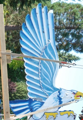
neon sign
https://search.heritageburnaby.ca/link/museumartifact86079
- Repository
- Burnaby Village Museum
- Accession Code
- BV016.18.2
- Description
- Eagle Ford neon sign. It is a large double-sided hollow sheet metal sign measuring 13.3 feet tall and 8.9 feet wide. The sheet metal and structure of the sign retains most of the eagle's original painted image, including the dramatic wings with their blue and white feather pattern.
- Object History
- Eagle Motors Limited was established by the well-known Burnaby businessman Frank McCracken at 4161 Hastings Street in 1948. The car dealership became a successful local Heights business and was the largest Ford car and truck retailer in the province during its operation. The company had adopted the silhouette of the classic Bald Eagle in full flight to serve as a logo which was utilized in advertising and promotional materials. The eagle symbol was famously developed into a classic chrome badge with the name "Eagle Ford - Burnaby, BC" that was installed on all the Eagle Ford cars and trucks sold by the dealership. After a new showroom building was constructed on the site in 1950, the company commissioned Neon Products of Vancouver to manufacture a very large double-sided neon eagle. Typical of neon signs of the era, the eagle was painted with dramatic designs and bright primary colours on metal with blue, white, and gold neon tubing serving to highlight the outline of the eagle.
- The "Burnaby Eagle" sign immediately became a landmark on the Burnaby Heights business district. From its high perch atop the dealership building, located at Carleton Street, the Burnaby Eagle shared the night sky with other nearby classic neon signs of the era including the "Swinging Girl" sign of the Helen's Children's Wear store. Eagle Motors was a successful dealership until the recession of the 1980s, and in 1985 the business was closed. Vandalism on the site resulted in damage to the neon tubing of the sign before the leased sign was reclaimed by its owner, Neon Products Limited. The sign was obtained by a local collector, who carefully looked after it for 25 years. In 2012, the sign was sold to the City of Burnaby.
- The sign will be restored and installed near its original location on Hastings Street in 2024.
- Reference
- Community Heritage Commission report to Council, September 17, 2012.
- Measurements
- Height: 14 ft. Width: 9 ft. Thickness: 14 in.
- Historic Neighbourhood
- Vancouver Heights (Historic Neighbourhood)
- Planning Study Area
- Burnaby Heights Area
Images

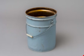
pail
https://search.heritageburnaby.ca/link/museumartifact89578
- Repository
- Burnaby Village Museum
- Accession Code
- BV018.31.9
- Description
- pail; large, steel "glucose" pail used at Valley Bakery; grey painted exterior, no lid, bail handle with opaque plastic grip; ca. 1950s; text stamped on bottom reads: "VULCAN / CTC-37C-80 / 28/26 79 / MADE IN CANADA / STC".
- Object History
- Object was used by donor at Valley Bakery, currently located at 4058 East Hastings Street, Valley Bakery opened in Burnaby in 1957 and is still owned and operated by the same family as of 2019.
- Category
- 04.Tools & Equipment for Materials
- Classification
- Food Processing & Preparation T&E - - Food Storage Equipment
- Object Term
- Container, Food Preparation
- Measurements
- H: 35.3 cm Dia.: 27.3 cm
- Historic Neighbourhood
- Vancouver Heights (Historic Neighbourhood)
- Planning Study Area
- Burnaby Heights Area
Images
