Narrow Results By
Subject
- Advertising Medium - Signs and Signboards 1
- Agriculture - Farms 1
- Animals - Dogs 2
- Animals - Poultry 1
- Arts 1
- Arts - Paintings 1
- Buildings - Civic 1
- Buildings - Civic - Fire Halls 1
- Buildings - Commercial 3
- Buildings - Commercial - Barber Shops 2
- Buildings - Commercial - Beauty Shops 2
- Buildings - Commercial - Hardware Stores 2
Creator
- Bartel, Mario 1
- Bingham, Alfred "Alf" 2
- Binks, James 1
- Blake, Frederick "Fred" 1
- Bowman and Cullerne 1
- Bowman & Cullerne 1
- British Columbia Underwriters' Association 6
- Burnaby Village Museum 1
- Burnett & McGugan, Engineers and Surveyors 1
- Charlton and Rathburn 1
- Eaton, Dr. Carl 1
- Heights Neighbourhood Association 1

100 Years of Gilmore School
https://search.heritageburnaby.ca/link/museumdescription4488
- Repository
- Burnaby Village Museum
- Date
- 2017
- Collection/Fonds
- 100 Years of Gilmore School video collection
- Description Level
- Item
- Physical Description
- 1 video recording (mp4) (34 min., 23 sec.) : digital, 29 fps, col., sd., stereo
- Scope and Content
- "100 Years of Gilmore School". Filmed by Yunuen Perez Vertti and made by the Heights Neighbourhood Association. The film includes interviews with former students and highlights their experiences through the Great Depression, the Second World War and the 1960s.
- Repository
- Burnaby Village Museum
- Collection/Fonds
- 100 Years of Gilmore School video collection
- Description Level
- Item
- Physical Description
- 1 video recording (mp4) (34 min., 23 sec.) : digital, 29 fps, col., sd., stereo
- Scope and Content
- "100 Years of Gilmore School". Filmed by Yunuen Perez Vertti and made by the Heights Neighbourhood Association. The film includes interviews with former students and highlights their experiences through the Great Depression, the Second World War and the 1960s.
- History
- Yunuen Perez Vertti is a filmmaker and digital media artist originally from Mexico City. She has produced films for many public, private and non-profit organizations.
- Creator
- Perez Vertti, Yunuen
- Names
- Gilmore Avenue School
- Responsibility
- Heights Neighbourhood Association
- Geographic Access
- Gilmore Avenue
- Street Address
- 50 Gilmore Avenue
- Accession Code
- BV018.13.1
- Access Restriction
- Restricted access
- Reproduction Restriction
- May be restricted by third party rights
- Date
- 2017
- Media Type
- Moving Images
- Historic Neighbourhood
- Vancouver Heights (Historic Neighbourhood)
- Planning Study Area
- Burnaby Heights Area
- Notes
- Transcribed title
- Reproductions are restricted by copyright holder
Images

Video
100 Years of Gilmore School, 2017
100 Years of Gilmore School, 2017
https://search.heritageburnaby.ca/media/hpo/_Data/_BVM_Moving_Images/2018_0013_0001_001.mp4![311 Madison Avenue, [1925] (date of original), copied 1991 thumbnail](/media/hpo/_Data/_Archives_Images/_Unrestricted/370/370-210.jpg?width=280)
311 Madison Avenue
https://search.heritageburnaby.ca/link/archivedescription37622
- Repository
- City of Burnaby Archives
- Date
- [1925] (date of original), copied 1991
- Collection/Fonds
- Burnaby Historical Society fonds
- Description Level
- Item
- Physical Description
- 1 photograph : b&w ; 2.9 x 4.5 cm print on contact sheet 20.2 x 25.3 cm
- Scope and Content
- Photograph of the exterior of 311 Madison Avenue.
- Repository
- City of Burnaby Archives
- Date
- [1925] (date of original), copied 1991
- Collection/Fonds
- Burnaby Historical Society fonds
- Subseries
- Burnaby Image Bank subseries
- Physical Description
- 1 photograph : b&w ; 2.9 x 4.5 cm print on contact sheet 20.2 x 25.3 cm
- Description Level
- Item
- Record No.
- 370-210
- Access Restriction
- No restrictions
- Reproduction Restriction
- No known restrictions
- Accession Number
- BHS1999-03
- Scope and Content
- Photograph of the exterior of 311 Madison Avenue.
- Subjects
- Buildings - Residential - Houses
- Media Type
- Photograph
- Notes
- Title based on contents of photograph
- 1 b&w copy negative accompanying
- Geographic Access
- Madison Avenue
- Street Address
- 311 Madison Avenue
- Historic Neighbourhood
- Vancouver Heights (Historic Neighbourhood)
- Planning Study Area
- Burnaby Heights Area
Images
![311 Madison Avenue, [1925] (date of original), copied 1991 thumbnail](/media/hpo/_Data/_Archives_Images/_Unrestricted/370/370-210.jpg)
1160 Douglas Rd
https://search.heritageburnaby.ca/link/archivedescription94327
- Repository
- City of Burnaby Archives
- Date
- December 1994
- Collection/Fonds
- Grover, Elliott & Co. Ltd. fonds
- Description Level
- File
- Physical Description
- 22 photographs : col. negatives ; 35 mm
- Scope and Content
- Photographs of the exterior of a three-storey commerical building located at 1160 Douglas Road.
- Repository
- City of Burnaby Archives
- Date
- December 1994
- Collection/Fonds
- Grover, Elliott & Co. Ltd. fonds
- Physical Description
- 22 photographs : col. negatives ; 35 mm
- Description Level
- File
- Record No.
- 622-112
- Access Restriction
- No restrictions
- Reproduction Restriction
- No restrictions
- Accession Number
- 2017-39
- Scope and Content
- Photographs of the exterior of a three-storey commerical building located at 1160 Douglas Road.
- Media Type
- Photograph
- Photographer
- Young, Richard
- Notes
- Transcribed title
- Title transcribed from envelope photographs were originally housed in
- File no. 94-424-B
- Geographic Access
- Douglas Road
- Street Address
- 1160 Douglas Road
- Historic Neighbourhood
- Vancouver Heights (Historic Neighbourhood)
- Planning Study Area
- Willingdon Heights Area
1850 Rosser Ave Burnaby
https://search.heritageburnaby.ca/link/archivedescription93890
- Repository
- City of Burnaby Archives
- Date
- June 1993
- Collection/Fonds
- Grover, Elliott & Co. Ltd. fonds
- Description Level
- File
- Physical Description
- 35 photographs : col. negatives ; 35 mm
- Scope and Content
- Photographs of an 18-storey residential tower located at 1850 Rosser Avenue.
- Repository
- City of Burnaby Archives
- Date
- June 1993
- Collection/Fonds
- Grover, Elliott & Co. Ltd. fonds
- Physical Description
- 35 photographs : col. negatives ; 35 mm
- Description Level
- File
- Record No.
- 622-073
- Access Restriction
- No restrictions
- Reproduction Restriction
- No restrictions
- Accession Number
- 2017-39
- Scope and Content
- Photographs of an 18-storey residential tower located at 1850 Rosser Avenue.
- Subjects
- Buildings - Residential
- Media Type
- Photograph
- Notes
- Transcribed title
- Title transcribed from envelope photographs were originally housed in
- File no. 93-268-B
- Note in blue pen on photograph envelope reads: "Rideau Manor".
- Photographer identified as "D.E."
- Geographic Access
- Rosser Avenue
- Street Address
- 1850 Rosser Avenue
- Historic Neighbourhood
- Vancouver Heights (Historic Neighbourhood)
- Planning Study Area
- Willingdon Heights Area
3717-3763 Albert Street
https://search.heritageburnaby.ca/link/archivedescription93763
- Repository
- City of Burnaby Archives
- Date
- June 26, 1992
- Collection/Fonds
- Grover, Elliott & Co. Ltd. fonds
- Description Level
- File
- Physical Description
- 16 photographs : col. negatives ; 35 mm
- Scope and Content
- Photographs of the residential houses and laneways located at 3717-3763 Albert Street - addresses that no longer exist. The property's current address is 3755 Albert Street.
- Repository
- City of Burnaby Archives
- Date
- June 26, 1992
- Collection/Fonds
- Grover, Elliott & Co. Ltd. fonds
- Physical Description
- 16 photographs : col. negatives ; 35 mm
- Description Level
- File
- Record No.
- 622-048
- Access Restriction
- No restrictions
- Reproduction Restriction
- No restrictions
- Accession Number
- 2017-39
- Scope and Content
- Photographs of the residential houses and laneways located at 3717-3763 Albert Street - addresses that no longer exist. The property's current address is 3755 Albert Street.
- Subjects
- Buildings - Residential - Houses
- Media Type
- Photograph
- Photographer
- Young, Richard
- Notes
- Transcribed title
- Title transcribed from envelope photographs were originally housed in
- File no. 92-247-B
- Geographic Access
- Albert Street
- Street Address
- 3755 Albert Street
- Historic Neighbourhood
- Vancouver Heights (Historic Neighbourhood)
- Planning Study Area
- Burnaby Heights Area
3900-3978 Hastings
https://search.heritageburnaby.ca/link/archivedescription93809
- Repository
- City of Burnaby Archives
- Date
- September 12, 1992
- Collection/Fonds
- Grover, Elliott & Co. Ltd. fonds
- Description Level
- File
- Physical Description
- 4 photographs : col. ; 10 cm x 15 cm
- Scope and Content
- Photographs of a two-storey commercial building located at 3900 through 3978 Hastings Street, with a residential tower visible behind it. Stores visible in the photograph include: Budget Video, a dental centre, a produce store, Autoplan Insurance, Da Vinci Travel, Great Pacific Management, and Hea…
- Repository
- City of Burnaby Archives
- Date
- September 12, 1992
- Collection/Fonds
- Grover, Elliott & Co. Ltd. fonds
- Physical Description
- 4 photographs : col. ; 10 cm x 15 cm
- Description Level
- File
- Record No.
- 622-057
- Access Restriction
- No restrictions
- Reproduction Restriction
- No restrictions
- Accession Number
- 2017-39
- Scope and Content
- Photographs of a two-storey commercial building located at 3900 through 3978 Hastings Street, with a residential tower visible behind it. Stores visible in the photograph include: Budget Video, a dental centre, a produce store, Autoplan Insurance, Da Vinci Travel, Great Pacific Management, and Head Waze Hair and Skin Studio.
- Media Type
- Photograph
- Notes
- Transcribed title
- Title transcribed from envelope photographs were originally housed in
- File no. 92-336-B
- Photographer identified as "J.C."
- Geographic Access
- Hastings Street
- Historic Neighbourhood
- Vancouver Heights (Historic Neighbourhood)
- Planning Study Area
- Burnaby Heights Area
4226 Hastings St.
https://search.heritageburnaby.ca/link/archivedescription94311
- Repository
- City of Burnaby Archives
- Date
- May 1994
- Collection/Fonds
- Grover, Elliott & Co. Ltd. fonds
- Description Level
- File
- Physical Description
- 18 photographs : col. negatives ; 35 mm
- Scope and Content
- Photographs of the commerical businesses located along the 4200 block of Hastings Street, including: Ultra X-Ray, Vote Reform, and United Optical
- Repository
- City of Burnaby Archives
- Date
- May 1994
- Collection/Fonds
- Grover, Elliott & Co. Ltd. fonds
- Physical Description
- 18 photographs : col. negatives ; 35 mm
- Description Level
- File
- Record No.
- 622-096
- Access Restriction
- No restrictions
- Reproduction Restriction
- No restrictions
- Accession Number
- 2017-39
- Scope and Content
- Photographs of the commerical businesses located along the 4200 block of Hastings Street, including: Ultra X-Ray, Vote Reform, and United Optical
- Subjects
- Buildings - Commercial
- Media Type
- Photograph
- Notes
- Transcribed title
- Title transcribed from envelope photographs were originally housed in
- File no. 94-190-B
- Photographer identified as "L.D."
- Geographic Access
- Hastings Street
- Street Address
- 4226 Hastings Street
- Historic Neighbourhood
- Vancouver Heights (Historic Neighbourhood)
- Planning Study Area
- Willingdon Heights Area
4430 Halifax Street
https://search.heritageburnaby.ca/link/archivedescription93810
- Repository
- City of Burnaby Archives
- Date
- September 12, 1992
- Collection/Fonds
- Grover, Elliott & Co. Ltd. fonds
- Description Level
- Item
- Physical Description
- 1 photograph : col. ; 10 cm x 15 cm
- Scope and Content
- Photograph of a two-storey office building located at 4430 Halifax Street. Photograph is of the rear of the building and a small parking lot, taken from Buchanan Street.
- Repository
- City of Burnaby Archives
- Date
- September 12, 1992
- Collection/Fonds
- Grover, Elliott & Co. Ltd. fonds
- Physical Description
- 1 photograph : col. ; 10 cm x 15 cm
- Description Level
- Item
- Record No.
- 622-058
- Access Restriction
- No restrictions
- Reproduction Restriction
- No restrictions
- Accession Number
- 2017-39
- Scope and Content
- Photograph of a two-storey office building located at 4430 Halifax Street. Photograph is of the rear of the building and a small parking lot, taken from Buchanan Street.
- Subjects
- Buildings - Commercial - Offices
- Media Type
- Photograph
- Notes
- Transcribed title
- Title transcribed from envelope photographs were originally housed in
- File no. 92-337-B
- Photographer identified as "J.C."
- Geographic Access
- Halifax Street
- Street Address
- 4430 Halifax Street
- Historic Neighbourhood
- Vancouver Heights (Historic Neighbourhood)
- Planning Study Area
- Willingdon Heights Area
4647-4649 Hastings
https://search.heritageburnaby.ca/link/archivedescription93808
- Repository
- City of Burnaby Archives
- Date
- September 12, 1992
- Collection/Fonds
- Grover, Elliott & Co. Ltd. fonds
- Description Level
- File
- Physical Description
- 3 photographs : col. ; 10 cm x 15 cm
- Scope and Content
- Photographs of the two-storey office building located at 4647-4649 Hastings Street.
- Repository
- City of Burnaby Archives
- Date
- September 12, 1992
- Collection/Fonds
- Grover, Elliott & Co. Ltd. fonds
- Physical Description
- 3 photographs : col. ; 10 cm x 15 cm
- Description Level
- File
- Record No.
- 622-056
- Access Restriction
- No restrictions
- Reproduction Restriction
- No restrictions
- Accession Number
- 2017-39
- Scope and Content
- Photographs of the two-storey office building located at 4647-4649 Hastings Street.
- Subjects
- Buildings - Commercial - Offices
- Media Type
- Photograph
- Notes
- Transcribed title
- Title transcribed from envelope photographs were originally housed in
- File no. 92-335-B
- Photographer identified as "J.C."
- Geographic Access
- Hastings Street
- Historic Neighbourhood
- Vancouver Heights (Historic Neighbourhood)
- Planning Study Area
- Burnaby Heights Area
![Bea and Don Carpenter, [1926] (date of original), copied 1991 thumbnail](/media/hpo/_Data/_Archives_Images/_Unrestricted/370/370-137.jpg?width=280)
Bea and Don Carpenter
https://search.heritageburnaby.ca/link/archivedescription37549
- Repository
- City of Burnaby Archives
- Date
- [1926] (date of original), copied 1991
- Collection/Fonds
- Burnaby Historical Society fonds
- Description Level
- Item
- Physical Description
- 1 photograph : b&w ; 4.9 x 2.7 cm print on contact sheet 20.2 x 25.3 cm
- Scope and Content
- Photograph of siblings Bea and Don Carpenter seated in a chair at the front of their home on the 4000 block of Cambridge Street. The photograph was taken facing the street. Note the carpet in front of the chair.
- Repository
- City of Burnaby Archives
- Date
- [1926] (date of original), copied 1991
- Collection/Fonds
- Burnaby Historical Society fonds
- Subseries
- Burnaby Image Bank subseries
- Physical Description
- 1 photograph : b&w ; 4.9 x 2.7 cm print on contact sheet 20.2 x 25.3 cm
- Description Level
- Item
- Record No.
- 370-137
- Access Restriction
- No restrictions
- Reproduction Restriction
- No known restrictions
- Accession Number
- BHS1999-03
- Scope and Content
- Photograph of siblings Bea and Don Carpenter seated in a chair at the front of their home on the 4000 block of Cambridge Street. The photograph was taken facing the street. Note the carpet in front of the chair.
- Subjects
- Furniture
- Media Type
- Photograph
- Notes
- Title based on contents of photograph
- 1 b&w copy negative accompanying
- Geographic Access
- Cambridge Street
- Historic Neighbourhood
- Vancouver Heights (Historic Neighbourhood)
- Planning Study Area
- Burnaby Heights Area
Images
![Bea and Don Carpenter, [1926] (date of original), copied 1991 thumbnail](/media/hpo/_Data/_Archives_Images/_Unrestricted/370/370-137.jpg)
![Bessie and Helen Stack, [192-] (date of original), copied 1992 thumbnail](/media/hpo/_Data/_Archives_Images/_Unrestricted/315/315-478.jpg?width=280)
Bessie and Helen Stack
https://search.heritageburnaby.ca/link/archivedescription37015
- Repository
- City of Burnaby Archives
- Date
- [192-] (date of original), copied 1992
- Collection/Fonds
- Burnaby Historical Society fonds
- Description Level
- Item
- Physical Description
- 1 photograph : b&w ; 8.3 x 11.4 cm print
- Scope and Content
- Photograph of sisters Elizabeth "Bessie" and Helen Stack outside their home on the 3900 block of Albert Street.
- Repository
- City of Burnaby Archives
- Date
- [192-] (date of original), copied 1992
- Collection/Fonds
- Burnaby Historical Society fonds
- Subseries
- Burnaby Centennial Anthology subseries
- Physical Description
- 1 photograph : b&w ; 8.3 x 11.4 cm print
- Description Level
- Item
- Record No.
- 315-478
- Access Restriction
- No restrictions
- Reproduction Restriction
- No known restrictions
- Accession Number
- BHS1994-04
- Scope and Content
- Photograph of sisters Elizabeth "Bessie" and Helen Stack outside their home on the 3900 block of Albert Street.
- Media Type
- Photograph
- Notes
- Title based on contents of photograph
- Geographic Access
- Albert Street
- Historic Neighbourhood
- Vancouver Heights (Historic Neighbourhood)
- Planning Study Area
- Burnaby Heights Area
Images
![Bessie and Helen Stack, [192-] (date of original), copied 1992 thumbnail](/media/hpo/_Data/_Archives_Images/_Unrestricted/315/315-478.jpg)
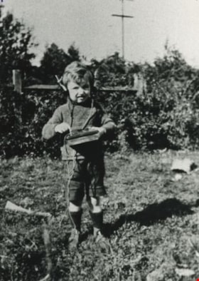
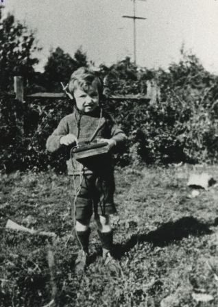
Bill Campbell with Crystal Radio Set
https://search.heritageburnaby.ca/link/archivedescription35787
- Repository
- City of Burnaby Archives
- Date
- 1923 (date of original), copied 1986
- Collection/Fonds
- Burnaby Historical Society fonds
- Description Level
- Item
- Physical Description
- 1 photograph : b&w ; 12.7 x 17.8 cm print
- Scope and Content
- Photograph of Bill Campbell with a crystal radio set built by his father, John Campbell.
- Repository
- City of Burnaby Archives
- Date
- 1923 (date of original), copied 1986
- Collection/Fonds
- Burnaby Historical Society fonds
- Subseries
- Pioneer Tales subseries
- Physical Description
- 1 photograph : b&w ; 12.7 x 17.8 cm print
- Description Level
- Item
- Record No.
- 204-645
- Access Restriction
- No restrictions
- Reproduction Restriction
- No known restrictions
- Accession Number
- BHS1988-03
- Scope and Content
- Photograph of Bill Campbell with a crystal radio set built by his father, John Campbell.
- Names
- Campbell, William "Bill"
- Media Type
- Photograph
- Notes
- Title based on contents of photograph
- Geographic Access
- Eton Street
- Street Address
- 4120 Eton Street
- Historic Neighbourhood
- Vancouver Heights (Historic Neighbourhood)
- Planning Study Area
- Burnaby Heights Area
Images
![Blasting stump, [1921 or 1922] (date of original), digitally copied 2012 thumbnail](/media/hpo/_Data/_Archives_Images/_Unrestricted/540/549-008.jpg?width=280)
Blasting stump
https://search.heritageburnaby.ca/link/archivedescription76891
- Repository
- City of Burnaby Archives
- Date
- [1921 or 1922] (date of original), digitally copied 2012
- Collection/Fonds
- Community Heritage Commission Special Projects fonds
- Description Level
- Item
- Physical Description
- 1 photograph (jpeg) : col. ; 300ppi
- Scope and Content
- Photograph of members of the Brown-John family sitting and standing on the blasting stump. This stump was located near the corner of Gilmore Avenue and Napier Street.
- Repository
- City of Burnaby Archives
- Date
- [1921 or 1922] (date of original), digitally copied 2012
- Collection/Fonds
- Community Heritage Commission Special Projects fonds
- Physical Description
- 1 photograph (jpeg) : col. ; 300ppi
- Description Level
- Item
- Record No.
- 549-008
- Access Restriction
- No restrictions
- Reproduction Restriction
- No known restrictions
- Accession Number
- 2012-30
- Scope and Content
- Photograph of members of the Brown-John family sitting and standing on the blasting stump. This stump was located near the corner of Gilmore Avenue and Napier Street.
- Subjects
- Plants - Trees
- Names
- Brown-John, Victor Joseph Charles
- Brown-John, Archie
- Brown-John, Frank
- Brown-John, Roy
- Ansdell, Elsie Brown-John
- Brown-John, Clive
- Media Type
- Photograph
- Notes
- Title based on contents of photograph
- Geographic Access
- Gilmore Avenue
- Napier Street
- Historic Neighbourhood
- Vancouver Heights (Historic Neighbourhood)
- Planning Study Area
- Willingdon Heights Area
Images
![Blasting stump, [1921 or 1922] (date of original), digitally copied 2012 thumbnail](/media/hpo/_Data/_Archives_Images/_Unrestricted/540/549-008.jpg)
![Blasting stump, [1920] (date of original), digitally copied 2012 thumbnail](/media/hpo/_Data/_Archives_Images/_Unrestricted/540/549-009.jpg?width=280)
Blasting stump
https://search.heritageburnaby.ca/link/archivedescription76892
- Repository
- City of Burnaby Archives
- Date
- [1920] (date of original), digitally copied 2012
- Collection/Fonds
- Community Heritage Commission Special Projects fonds
- Description Level
- Item
- Physical Description
- 1 photograph (jpeg) : col. ; 300ppi
- Scope and Content
- Photograph of the Brown-John children playing on the blasting stump that was located near the corner of Gilmore Avenue and Napier Street.
- Repository
- City of Burnaby Archives
- Date
- [1920] (date of original), digitally copied 2012
- Collection/Fonds
- Community Heritage Commission Special Projects fonds
- Physical Description
- 1 photograph (jpeg) : col. ; 300ppi
- Description Level
- Item
- Record No.
- 549-009
- Access Restriction
- No restrictions
- Reproduction Restriction
- No known restrictions
- Accession Number
- 2012-30
- Scope and Content
- Photograph of the Brown-John children playing on the blasting stump that was located near the corner of Gilmore Avenue and Napier Street.
- Subjects
- Plants - Trees
- Media Type
- Photograph
- Notes
- Title based on contents of photograph
- Geographic Access
- Gilmore Avenue
- Napier Street
- Historic Neighbourhood
- Vancouver Heights (Historic Neighbourhood)
- Planning Study Area
- Willingdon Heights Area
Images
![Blasting stump, [1920] (date of original), digitally copied 2012 thumbnail](/media/hpo/_Data/_Archives_Images/_Unrestricted/540/549-009.jpg)
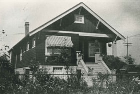
Bradbury family home
https://search.heritageburnaby.ca/link/archivedescription35377
- Repository
- City of Burnaby Archives
- Date
- 1927 (date of original), copied 1986
- Collection/Fonds
- Burnaby Historical Society fonds
- Description Level
- Item
- Physical Description
- 1 photograph : b&w ; 12.7 x 17.8 cm print
- Scope and Content
- Photograph of the Percival Bradbury family home in the 4100 block of Albert Street, North Burnaby. Percival was married to Kate Bradbury and settled in Burnaby in 1927. Later, the family moved south of Hastings Street.
- Repository
- City of Burnaby Archives
- Date
- 1927 (date of original), copied 1986
- Collection/Fonds
- Burnaby Historical Society fonds
- Subseries
- Pioneer Tales subseries
- Physical Description
- 1 photograph : b&w ; 12.7 x 17.8 cm print
- Description Level
- Item
- Record No.
- 204-234
- Access Restriction
- No restrictions
- Reproduction Restriction
- No known restrictions
- Accession Number
- BHS1988-03
- Scope and Content
- Photograph of the Percival Bradbury family home in the 4100 block of Albert Street, North Burnaby. Percival was married to Kate Bradbury and settled in Burnaby in 1927. Later, the family moved south of Hastings Street.
- Subjects
- Buildings - Residential - Houses
- Media Type
- Photograph
- Notes
- Title based on contents of photograph
- Geographic Access
- Albert Street
- Historic Neighbourhood
- Vancouver Heights (Historic Neighbourhood)
- Planning Study Area
- Burnaby Heights Area
Images


Brown Family and Home
https://search.heritageburnaby.ca/link/archivedescription35673
- Repository
- City of Burnaby Archives
- Date
- 1920 (date of original), copied 1986
- Collection/Fonds
- Burnaby Historical Society fonds
- Description Level
- Item
- Physical Description
- 1 photograph : b&w ; 12.7 x 17.8 cm print
- Scope and Content
- Photograph of the Brown family feeding chickens. From left: Alex Brown (brother, later to become MD), Janet Brown (sister), and Janet Mackintosh Macfarlane Maclean (grandmother). This photograph was taken in back of the Brown family home, 3846 Triumph, Vancouver Heights. The house was owned by t…
- Repository
- City of Burnaby Archives
- Date
- 1920 (date of original), copied 1986
- Collection/Fonds
- Burnaby Historical Society fonds
- Subseries
- Pioneer Tales subseries
- Physical Description
- 1 photograph : b&w ; 12.7 x 17.8 cm print
- Description Level
- Item
- Record No.
- 204-531
- Access Restriction
- No restrictions
- Reproduction Restriction
- No known restrictions
- Accession Number
- BHS1988-03
- Scope and Content
- Photograph of the Brown family feeding chickens. From left: Alex Brown (brother, later to become MD), Janet Brown (sister), and Janet Mackintosh Macfarlane Maclean (grandmother). This photograph was taken in back of the Brown family home, 3846 Triumph, Vancouver Heights. The house was owned by the grandmother.
- Subjects
- Animals - Poultry
- Agriculture - Farms
- Media Type
- Photograph
- Notes
- Title based on contents of photograph
- Geographic Access
- Triumph Street
- Street Address
- 3846 Triumph Street
- Historic Neighbourhood
- Vancouver Heights (Historic Neighbourhood)
- Planning Study Area
- Burnaby Heights Area
Images

![Brown-John home, [192-] (date of original), digitally copied 2012 thumbnail](/media/hpo/_Data/_Archives_Images/_Unrestricted/540/549-007.jpg?width=280)
Brown-John home
https://search.heritageburnaby.ca/link/archivedescription76890
- Repository
- City of Burnaby Archives
- Date
- [192-] (date of original), digitally copied 2012
- Collection/Fonds
- Community Heritage Commission Special Projects fonds
- Description Level
- Item
- Physical Description
- 1 photograph (jpeg) : col. ; 300ppi
- Scope and Content
- Photograph of the Brown-John home in Burnaby. Four large trucks are visible parked in front of the house.
- Repository
- City of Burnaby Archives
- Date
- [192-] (date of original), digitally copied 2012
- Collection/Fonds
- Community Heritage Commission Special Projects fonds
- Physical Description
- 1 photograph (jpeg) : col. ; 300ppi
- Description Level
- Item
- Record No.
- 549-007
- Access Restriction
- No restrictions
- Reproduction Restriction
- No known restrictions
- Accession Number
- 2012-30
- Scope and Content
- Photograph of the Brown-John home in Burnaby. Four large trucks are visible parked in front of the house.
- Media Type
- Photograph
- Notes
- Title based on contents of photograph
- Geographic Access
- Hastings Street
- Historic Neighbourhood
- Vancouver Heights (Historic Neighbourhood)
- Planning Study Area
- Willingdon Heights Area
Images
![Brown-John home, [192-] (date of original), digitally copied 2012 thumbnail](/media/hpo/_Data/_Archives_Images/_Unrestricted/540/549-007.jpg)
![Burnaby Heights mural, [1999] thumbnail](/media/hpo/_Data/_Archives_Images/_Unrestricted/535/535-3349.jpg?width=280)
Burnaby Heights mural
https://search.heritageburnaby.ca/link/archivedescription98339
- Repository
- City of Burnaby Archives
- Date
- [1999]
- Collection/Fonds
- Burnaby NewsLeader photograph collection
- Description Level
- Item
- Physical Description
- 1 photograph (tiff) : col.
- Scope and Content
- Photograph of Cindy Johnson, of Golden Dream Murals, painting a mural that was commissioned by the Heights Merchants Association on the 4000 block of Hastings Street.
- Repository
- City of Burnaby Archives
- Date
- [1999]
- Collection/Fonds
- Burnaby NewsLeader photograph collection
- Physical Description
- 1 photograph (tiff) : col.
- Description Level
- Item
- Record No.
- 535-3349
- Access Restriction
- No restrictions
- Reproduction Restriction
- No restrictions
- Accession Number
- 2018-12
- Scope and Content
- Photograph of Cindy Johnson, of Golden Dream Murals, painting a mural that was commissioned by the Heights Merchants Association on the 4000 block of Hastings Street.
- Subjects
- Arts - Paintings
- Occupations - Artists
- Media Type
- Photograph
- Photographer
- Bartel, Mario
- Notes
- Title based on caption
- Collected by editorial for use in an October 1999 issue of the Burnaby NewsLeader
- Caption from metadata: "Cindy Johnson, of Golden Dream Murals, puts the final touches on a new mural behind the Bank of Nova Scotia on Hastings St. The mural is a joint venture between local businesses and The Heights Merchants Association."
- Geographic Access
- Hastings Street
- Historic Neighbourhood
- Vancouver Heights (Historic Neighbourhood)
- Planning Study Area
- Burnaby Heights Area
Images
![Burnaby Heights mural, [1999] thumbnail](/media/hpo/_Data/_Archives_Images/_Unrestricted/535/535-3349.jpg)

Burnaby Heights Neighbourhood
https://search.heritageburnaby.ca/link/landmark776
- Repository
- Burnaby Heritage Planning
- Associated Dates
- 1955-2008
- Heritage Value
- Up until the 1970s, this neighbourhood was known as Vancouver Heights. When a new park was created during that decade and named "Burnaby Heights Park," the name was gradually adopted by newcomers to the area. Today, you will hear residents refer to their neighbourhood as Burnaby Heights, Vancouver Heights, or just "The Heights." Throughout the 1960s and 1970s, the commercial district in this neighbourhood continued to grow and a Retail Merchants Association was formed which later became known as the Heights Merchants Association. The neighbourhood still retains a residential neighbourhood characteristic with an increasing number of apartment buildings and multi-family units being built over the past 20 years.
- Historic Neighbourhood
- Vancouver Heights (Historic Neighbourhood)
- Planning Study Area
- Burnaby Heights Area
Images

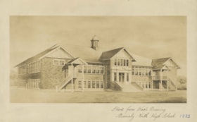
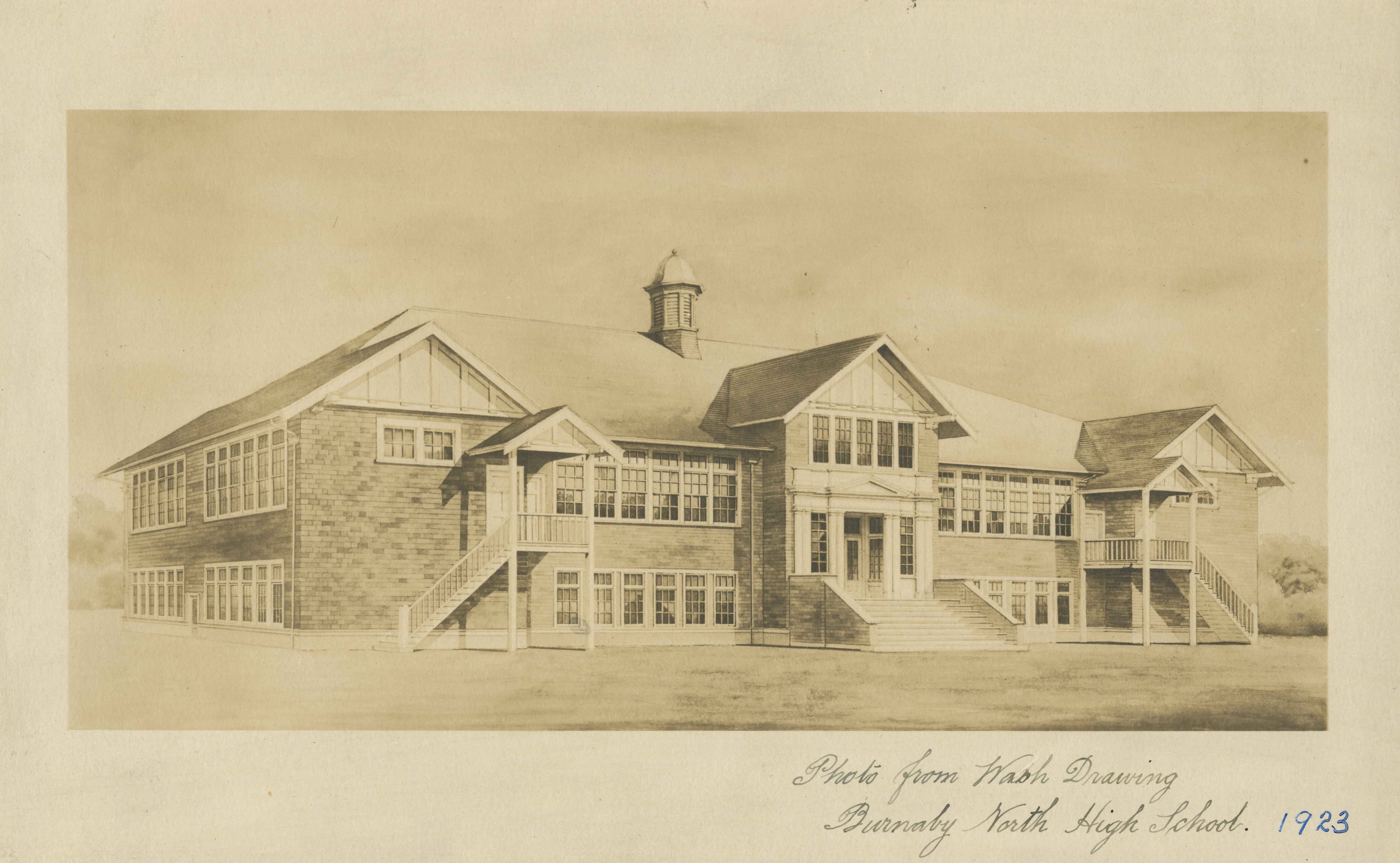
Burnaby North High School
https://search.heritageburnaby.ca/link/archivedescription34514
- Repository
- City of Burnaby Archives
- Date
- September 1923
- Collection/Fonds
- Burnaby Historical Society fonds
- Description Level
- Item
- Physical Description
- 1 photograph : b&w ; 16.0 x 25.5 cm
- Scope and Content
- Photograph of a wash drawing of the exterior of Burnaby North High School. This building later became Rosser Elementary School.
- Repository
- City of Burnaby Archives
- Date
- September 1923
- Collection/Fonds
- Burnaby Historical Society fonds
- Subseries
- Jeanie Brown subseries
- Physical Description
- 1 photograph : b&w ; 16.0 x 25.5 cm
- Description Level
- Item
- Record No.
- 033-002
- Access Restriction
- No restrictions
- Reproduction Restriction
- No known restrictions
- Accession Number
- BHS2007-04
- Scope and Content
- Photograph of a wash drawing of the exterior of Burnaby North High School. This building later became Rosser Elementary School.
- Media Type
- Photograph
- Notes
- Title based on contents of photograph
- Annotation at bottom of photograph reads, "Photo from Wash Drawing / Burnaby North High School"
- Annotation on back of photograph reads, "Compliments of the Architects Bowrman and Cullerne, September, 1923"
- Geographic Access
- Pandora Street
- Street Address
- 4375 Pandora Street
- Historic Neighbourhood
- Vancouver Heights (Historic Neighbourhood)
- Planning Study Area
- Burnaby Heights Area
Images