Narrow Results By
Subject
- Advertising Medium - Signs and Signboards 1
- Agriculture - Farms 3
- Animals - Horses 2
- Buildings - Civic - Museums 3
- Buildings - Commercial - Restaurants 1
- Buildings - Heritage 7
- Buildings - Public - Detention Facilities 1
- Buildings - Religious - Churches 1
- Buildings - Residences - Houses 2
- Buildings - Residential 1
- Buildings - Residential - Boathouses 1
- Buildings - Residential - Houses 15
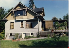
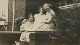
![Anna and Dinty Moore, [1928] (date of original), copied 1991 thumbnail](/media/hpo/_Data/_Archives_Images/_Unrestricted/370/370-587.jpg?width=280)
Anna and Dinty Moore
https://search.heritageburnaby.ca/link/archivedescription38000
- Repository
- City of Burnaby Archives
- Date
- [1928] (date of original), copied 1991
- Collection/Fonds
- Burnaby Historical Society fonds
- Description Level
- Item
- Physical Description
- 1 photograph : b&w ; 2.5 x 4.5 cm print on contact sheet 20.5 x 26.4 cm
- Scope and Content
- Photograph of Anna and William A. "Dinty" Moore at Hart House. Anna is seated on a tricycle.
- Repository
- City of Burnaby Archives
- Date
- [1928] (date of original), copied 1991
- Collection/Fonds
- Burnaby Historical Society fonds
- Subseries
- Burnaby Image Bank subseries
- Physical Description
- 1 photograph : b&w ; 2.5 x 4.5 cm print on contact sheet 20.5 x 26.4 cm
- Description Level
- Item
- Record No.
- 370-587
- Access Restriction
- No restrictions
- Reproduction Restriction
- No known restrictions
- Accession Number
- BHS1999-03
- Scope and Content
- Photograph of Anna and William A. "Dinty" Moore at Hart House. Anna is seated on a tricycle.
- Subjects
- Transportation - Bicycles
- Media Type
- Photograph
- Notes
- Title based on contents of photograph
- 1 b&w copy negative accompanying
- Geographic Access
- Deer Lake Avenue
- Street Address
- 6664 Deer Lake Avenue
- Historic Neighbourhood
- Burnaby Lake (Historic Neighbourhood)
- Planning Study Area
- Morley-Buckingham Area
Images
![Anna and Dinty Moore, [1928] (date of original), copied 1991 thumbnail](/media/hpo/_Data/_Archives_Images/_Unrestricted/370/370-587.jpg)
![Antique cars on Hill Street, [198-] thumbnail](/media/hpo/_Data/_BVM_Images/2020/2020_0005_0934_001.jpg?width=280)
Antique cars on Hill Street
https://search.heritageburnaby.ca/link/museumdescription13743
- Repository
- Burnaby Village Museum
- Date
- [198-]
- Collection/Fonds
- Century Park Museum Association fonds
- Description Level
- Item
- Physical Description
- 1 photograph : col. ; 10 x 15 cm
- Scope and Content
- Photograph of Hill Street inside Heritage Village Museum. Visitors are gathered along the street to view antique cars and buildings are decorated with red, white and blue bunting.
- Repository
- Burnaby Village Museum
- Collection/Fonds
- Century Park Museum Association fonds
- Description Level
- Item
- Physical Description
- 1 photograph : col. ; 10 x 15 cm
- Scope and Content
- Photograph of Hill Street inside Heritage Village Museum. Visitors are gathered along the street to view antique cars and buildings are decorated with red, white and blue bunting.
- Names
- Burnaby Village Museum
- Geographic Access
- Deer Lake Avenue
- Accession Code
- BV020.5.934
- Access Restriction
- No restrictions
- Reproduction Restriction
- No known restrictions
- Date
- [198-]
- Media Type
- Photograph
- Historic Neighbourhood
- Burnaby Lake (Historic Neighbourhood)
- Planning Study Area
- Morley-Buckingham Area
- Scan Resolution
- 600
- Scan Date
- 22-Sep-2020
- Scale
- 100
- Notes
- Title based on contents of photograph
Images
![Antique cars on Hill Street, [198-] thumbnail](/media/hpo/_Data/_BVM_Images/2020/2020_0005_0934_001.jpg)
Back of Mawhinney house
https://search.heritageburnaby.ca/link/museumdescription15558
- Repository
- Burnaby Village Museum
- Date
- 1987
- Collection/Fonds
- Reverend Edward S. Gale fonds
- Description Level
- Item
- Physical Description
- 1 photograph : col. ; 9 x 12.5 cm
- Scope and Content
- Photograph of the back of the Mawhinney house located at 7667 Burris Street in Burnaby. A large back porch (deck) is attached to the right side of the house.
- Repository
- Burnaby Village Museum
- Collection/Fonds
- Reverend Edward S. Gale fonds
- Description Level
- Item
- Physical Description
- 1 photograph : col. ; 9 x 12.5 cm
- Scope and Content
- Photograph of the back of the Mawhinney house located at 7667 Burris Street in Burnaby. A large back porch (deck) is attached to the right side of the house.
- Geographic Access
- Burris Street
- Street Address
- 7667 Burris Street
- Accession Code
- BV018.9.44
- Access Restriction
- No restrictions
- Reproduction Restriction
- May be restricted by third party rights
- Date
- 1987
- Media Type
- Photograph
- Planning Study Area
- Morley-Buckingham Area
- Scan Resolution
- 600
- Scan Date
- April 15, 2021
- Scale
- 100
- Notes
- Title based on contents of photograph
Images

Back of Mawhinney house
https://search.heritageburnaby.ca/link/museumdescription15560
- Repository
- Burnaby Village Museum
- Date
- 1988
- Collection/Fonds
- Reverend Edward S. Gale fonds
- Description Level
- Item
- Physical Description
- 1 photograph : col. ; 9 x 12.5 cm
- Scope and Content
- Photograph of the back of the Mawhinney house located at 7667 Burris Street in Burnaby. A large back porch (deck) is attached to the right side of the house. Photograph was taken after the house was painted.
- Repository
- Burnaby Village Museum
- Collection/Fonds
- Reverend Edward S. Gale fonds
- Description Level
- Item
- Physical Description
- 1 photograph : col. ; 9 x 12.5 cm
- Scope and Content
- Photograph of the back of the Mawhinney house located at 7667 Burris Street in Burnaby. A large back porch (deck) is attached to the right side of the house. Photograph was taken after the house was painted.
- Geographic Access
- Burris Street
- Street Address
- 7667 Burris Street
- Accession Code
- BV018.9.26
- Access Restriction
- No restrictions
- Reproduction Restriction
- May be restricted by third party rights
- Date
- 1988
- Media Type
- Photograph
- Planning Study Area
- Morley-Buckingham Area
- Related Material
- See also BV018.9.44
- Scan Resolution
- 600
- Scan Date
- April 20, 2021
- Scale
- 100
- Notes
- Title based on contents of photograph
Images

Back yard of Mawhinney house
https://search.heritageburnaby.ca/link/museumdescription15561
- Repository
- Burnaby Village Museum
- Date
- August 1984
- Collection/Fonds
- Reverend Edward S. Gale fonds
- Description Level
- Item
- Physical Description
- 1 photograph : col. ; 10 x 15 cm
- Scope and Content
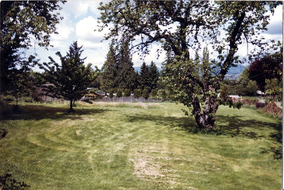
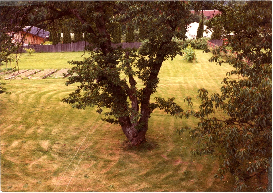
- Photograph of the back yard of the Mervin Mawhinney house looking north from the back deck before any of the subsequent landscaping was done by Reverend Gale. Tree on the right is a cherry tree. The house is located at 7667 Burris Street.
- Repository
- Burnaby Village Museum
- Collection/Fonds
- Reverend Edward S. Gale fonds
- Description Level
- Item
- Physical Description
- 1 photograph : col. ; 10 x 15 cm
- Scope and Content
- Photograph of the back yard of the Mervin Mawhinney house looking north from the back deck before any of the subsequent landscaping was done by Reverend Gale. Tree on the right is a cherry tree. The house is located at 7667 Burris Street.
- Geographic Access
- Burris Street
- Street Address
- 7667 Burris Street
- Accession Code
- BV018.9.27
- Access Restriction
- No restrictions
- Reproduction Restriction
- May be restricted by third party rights
- Date
- August 1984
- Media Type
- Photograph
- Planning Study Area
- Morley-Buckingham Area
- Scan Resolution
- 600
- Scan Date
- April 20, 2021
- Scale
- 100
- Notes
- Title based on contents of photograph
- Note in black ink on verso of photograph reads: "August '84"
Images

Back yard of Mawhinney house
https://search.heritageburnaby.ca/link/museumdescription15563
- Repository
- Burnaby Village Museum
- Date
- August 1984
- Collection/Fonds
- Reverend Edward S. Gale fonds
- Description Level
- Item
- Physical Description
- 1 photograph : col. ; 10 x 15 cm
- Scope and Content
- Photograph of the back yard of the Mervin Mawhinney house looking north from the back deck before any of the subsequent landscaping was done by Reverend Gale. Tree on the right is a cherry tree. The house is located at 7667 Burris Street.
- Repository
- Burnaby Village Museum
- Collection/Fonds
- Reverend Edward S. Gale fonds
- Description Level
- Item
- Physical Description
- 1 photograph : col. ; 10 x 15 cm
- Scope and Content
- Photograph of the back yard of the Mervin Mawhinney house looking north from the back deck before any of the subsequent landscaping was done by Reverend Gale. Tree on the right is a cherry tree. The house is located at 7667 Burris Street.
- Geographic Access
- Burris Street
- Street Address
- 7667 Burris Street
- Accession Code
- BV018.9.29
- Access Restriction
- No restrictions
- Reproduction Restriction
- May be restricted by third party rights
- Date
- August 1984
- Media Type
- Photograph
- Planning Study Area
- Morley-Buckingham Area
- Scan Resolution
- 600
- Scan Date
- April 20, 2021
- Scale
- 100
- Notes
- Title based on contents of photograph
Images
Back yard of Mawhinney house
https://search.heritageburnaby.ca/link/museumdescription15565
- Repository
- Burnaby Village Museum
- Date
- August 1984
- Collection/Fonds
- Reverend Edward S. Gale fonds
- Description Level
- Item
- Physical Description
- 1 photograph : col. ; 10 x 15 cm
- Scope and Content
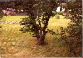
- Photograph of the back yard of the Mervin Mawhinney house located at 7667 Burris Street in Burnaby. A large cherry tree is in the centre of the photograph and a row of rectangular garden beds are visible in the background along with a wooden fence and neighbouring house.
- Repository
- Burnaby Village Museum
- Collection/Fonds
- Reverend Edward S. Gale fonds
- Description Level
- Item
- Physical Description
- 1 photograph : col. ; 10 x 15 cm
- Scope and Content
- Photograph of the back yard of the Mervin Mawhinney house located at 7667 Burris Street in Burnaby. A large cherry tree is in the centre of the photograph and a row of rectangular garden beds are visible in the background along with a wooden fence and neighbouring house.
- Geographic Access
- Burris Street
- Street Address
- 7667 Burris Street
- Accession Code
- BV018.9.31
- Access Restriction
- No restrictions
- Reproduction Restriction
- May be restricted by third party rights
- Date
- August 1984
- Media Type
- Photograph
- Planning Study Area
- Morley-Buckingham Area
- Scan Resolution
- 600
- Scan Date
- April 15, 2021
- Scale
- 100
- Notes
- Title based on contents of photograph
Images
Bank of Nova Scotia tennis party
https://search.heritageburnaby.ca/link/archivedescription39215
- Repository
- City of Burnaby Archives
- Date
- 1926
- Collection/Fonds
- Peers Family and Hill Family fonds
- Description Level
- Item
- Physical Description
- 1 photograph : b&w ; 6.5 x 10.5 cm on page 24.5 x 32.5 cm (pasted in album)
- Scope and Content
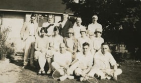
- Photograph of the staff of the Bank of Nova Scotia on the lawn of the Peers family home, Greyfriars, during a tennis party. Bob Peers is seated on the ground, in the centre of the first row (holding a tennis racket.)
- Repository
- City of Burnaby Archives
- Date
- 1926
- Collection/Fonds
- Peers Family and Hill Family fonds
- Physical Description
- 1 photograph : b&w ; 6.5 x 10.5 cm on page 24.5 x 32.5 cm (pasted in album)
- Description Level
- Item
- Record No.
- 477-534
- Access Restriction
- No restrictions
- Reproduction Restriction
- No known restrictions
- Accession Number
- 2007-12
- Scope and Content
- Photograph of the staff of the Bank of Nova Scotia on the lawn of the Peers family home, Greyfriars, during a tennis party. Bob Peers is seated on the ground, in the centre of the first row (holding a tennis racket.)
- Media Type
- Photograph
- Notes
- Title based on caption accompanying photograph
- Geographic Access
- Rugby Street
- Street Address
- 5289 Rugby Avenue
- Historic Neighbourhood
- Burnaby Lake (Historic Neighbourhood)
- Planning Study Area
- Morley-Buckingham Area
Images

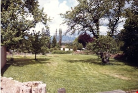
![Bateman gardens, [192-] thumbnail](/media/hpo/_Data/_BVM_Images/1976/1976_0037_0003_001.jpg?width=280)
Bateman gardens
https://search.heritageburnaby.ca/link/museumdescription678
- Repository
- Burnaby Village Museum
- Date
- [192-]
- Collection/Fonds
- E.W. Bateman family fonds
- Description Level
- Item
- Physical Description
- 1 photograph : b&w ; 9.1 x 13.8 cm
- Scope and Content
- Photograph of the Batemen family gardens. Edwin W. and Mary Batemen built their house, "Elworth," as a retirement home. It is located at the site of what would become Burnaby Village Museum, 6501 Deer Lake Avenue. Three unidentified people are standing on the far side of a gravel path laid out in …
- Repository
- Burnaby Village Museum
- Collection/Fonds
- E.W. Bateman family fonds
- Description Level
- Item
- Physical Description
- 1 photograph : b&w ; 9.1 x 13.8 cm
- Scope and Content
- Photograph of the Batemen family gardens. Edwin W. and Mary Batemen built their house, "Elworth," as a retirement home. It is located at the site of what would become Burnaby Village Museum, 6501 Deer Lake Avenue. Three unidentified people are standing on the far side of a gravel path laid out in the garden. A shed and a small cottage can be seen also.
- Subjects
- Geographic Features - Gardens
- Geographic Access
- Deer Lake Avenue
- Street Address
- 6501 Deer Lake Avenue
- Accession Code
- HV976.37.3
- Access Restriction
- No restrictions
- Reproduction Restriction
- No known restrictions
- Date
- [192-]
- Media Type
- Photograph
- Historic Neighbourhood
- Burnaby Lake (Historic Neighbourhood)
- Planning Study Area
- Morley-Buckingham Area
- Scan Resolution
- 600
- Scan Date
- 2023-06-13
- Notes
- Title based on contents of photograph
Images
![Bateman gardens, [192-] thumbnail](/media/hpo/_Data/_BVM_Images/1976/1976_0037_0003_001.jpg)
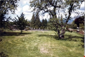
![Bateman gardens, [192-] thumbnail](/media/hpo/_Data/_BVM_Images/1976/1976_0037_0004_001.jpg?width=280)
Bateman gardens
https://search.heritageburnaby.ca/link/museumdescription679
- Repository
- Burnaby Village Museum
- Date
- [192-]
- Collection/Fonds
- E.W. Bateman family fonds
- Description Level
- Item
- Physical Description
- 1 photograph : b&w ; 9.1 x 13.8 cm
- Scope and Content
- Photograph of the Batemen family gardens. Edwin W. and Mary Batemen built their house, "Elworth," as a retirement home. It is located at the site of what would become Burnaby Village Museum, 6501 Deer Lake Avenue. A view is seen looking out towards the entrance into the garden and the road runnin…
- Repository
- Burnaby Village Museum
- Collection/Fonds
- E.W. Bateman family fonds
- Description Level
- Item
- Physical Description
- 1 photograph : b&w ; 9.1 x 13.8 cm
- Scope and Content
- Photograph of the Batemen family gardens. Edwin W. and Mary Batemen built their house, "Elworth," as a retirement home. It is located at the site of what would become Burnaby Village Museum, 6501 Deer Lake Avenue. A view is seen looking out towards the entrance into the garden and the road running across just outside of the gardens. Power poles can be seen along the road, and a greenhouse can be seen on a different plot of land across the street.
- Subjects
- Geographic Features - Gardens
- Geographic Access
- Deer Lake Avenue
- Street Address
- 6501 Deer Lake Avenue
- Accession Code
- HV976.37.4
- Access Restriction
- No restrictions
- Reproduction Restriction
- No known restrictions
- Date
- [192-]
- Media Type
- Photograph
- Historic Neighbourhood
- Burnaby Lake (Historic Neighbourhood)
- Planning Study Area
- Morley-Buckingham Area
- Scan Resolution
- 600
- Scan Date
- 2023-06-13
- Notes
- Title based on contents of photograph
Images
![Bateman gardens, [192-] thumbnail](/media/hpo/_Data/_BVM_Images/1976/1976_0037_0004_001.jpg)

Bell's Drygoods Store
https://search.heritageburnaby.ca/link/landmark537
- Repository
- Burnaby Heritage Planning
- Description
- Bell’s Drygoods Store is a typical commercial false front, single storey, wood-frame building that has been relocated to the Burnaby Village Museum.
- Associated Dates
- 1922
- Formal Recognition
- Heritage Designation, Community Heritage Register
- Other Names
- Whitechurch Hardware Store
- Repository
- Burnaby Heritage Planning
- Other Names
- Whitechurch Hardware Store
- Geographic Access
- Deer Lake Avenue
- Associated Dates
- 1922
- Formal Recognition
- Heritage Designation, Community Heritage Register
- Enactment Type
- Bylaw No. 9807
- Enactment Date
- 23/11/1992
- Description
- Bell’s Drygoods Store is a typical commercial false front, single storey, wood-frame building that has been relocated to the Burnaby Village Museum.
- Heritage Value
- The value of the Bell’s Drygoods Store lies in its significance as one of the last remaining intact false front retail structures of its time to survive in Burnaby. Additionally, it remains as one of East Burnaby’s few surviving early commercial buildings and is representative of other typical commercial structures of the period. Originally located on Sixth Street in East Burnaby, in a small commercial district that served residents located along the streetcar line between New Westminster and Edmonds, its proximity to the streetcar served to draw customers into the store. This store also served as the location of the East Burnaby Post Office, one of a number of local post offices located throughout the municipality during the early twentieth century. Clifford Tuckey constructed the building in 1922, with a small lean-to structure on the back housing a kitchen and bedroom. The store was sold soon afterwards to William and Flora Bell, who then lived and worked here for a number of years. It represents a traditional relationship of the owner’s home to the store during this period, indicating the modest means of the owners and their commitment to running the business. The building was later sold to Maurice and Mildred Whitechurch, who ran it for many years as a hardware store. In 1974, the structure was relocated to its present site at the Museum. The heritage value for this structure also lies in its interpretive value within the Burnaby Village Museum. The site is an important cultural feature for the interpretation of Burnaby’s heritage to the public. Between 1993 and 1996 the building was restored to its 1925 appearance.
- Defining Elements
- The character defining features of Bell’s Drygoods Store include its: - rectangular form and simple massing - commercial false front parapet - front gable roof with cedar shingle cladding - horizontal lapped wooden siding - recessed main central entrance flanked by large storefront display windows - V-joint tongue-and-groove wood interior paneling - interior separation between commercial and residential space
- Locality
- Deer Lake Park
- Historic Neighbourhood
- Burnaby Lake (Historic Neighbourhood)
- Planning Study Area
- Morley-Buckingham Area
- Organization
- Burnaby Village Museum
- Function
- Primary Current--Museum
- Primary Historic--Shop
- Community
- Burnaby
- Cadastral Identifier
- P.I.D. No. 011-030-356 Legal Description: Parcel 1, District Lot 79 and District Lot 85, Group 1, New Westminster District, Reference Plan 77594
- Boundaries
- Burnaby Village Museum is comprised of a single municipally-owned property located at 6501 Deer Lake Avenue, Burnaby.
- Area
- 38,488.63
- Contributing Resource
- Building
- Landscape Feature
- Structure
- Ownership
- Public (local)
- Documentation
- Heritage Site Files: PC77000 20. City of Burnaby Planning and Building Department, 4949 Canada Way, Burnaby, B.C., V5G 1M2
- Street Address
- 6501 Deer Lake Avenue
Images


![Bob, Betty and Dick Peers, [192-] thumbnail](/media/hpo/_Data/_Archives_Images/_Unrestricted/477/477-628.jpg?width=280)
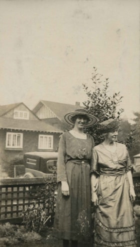
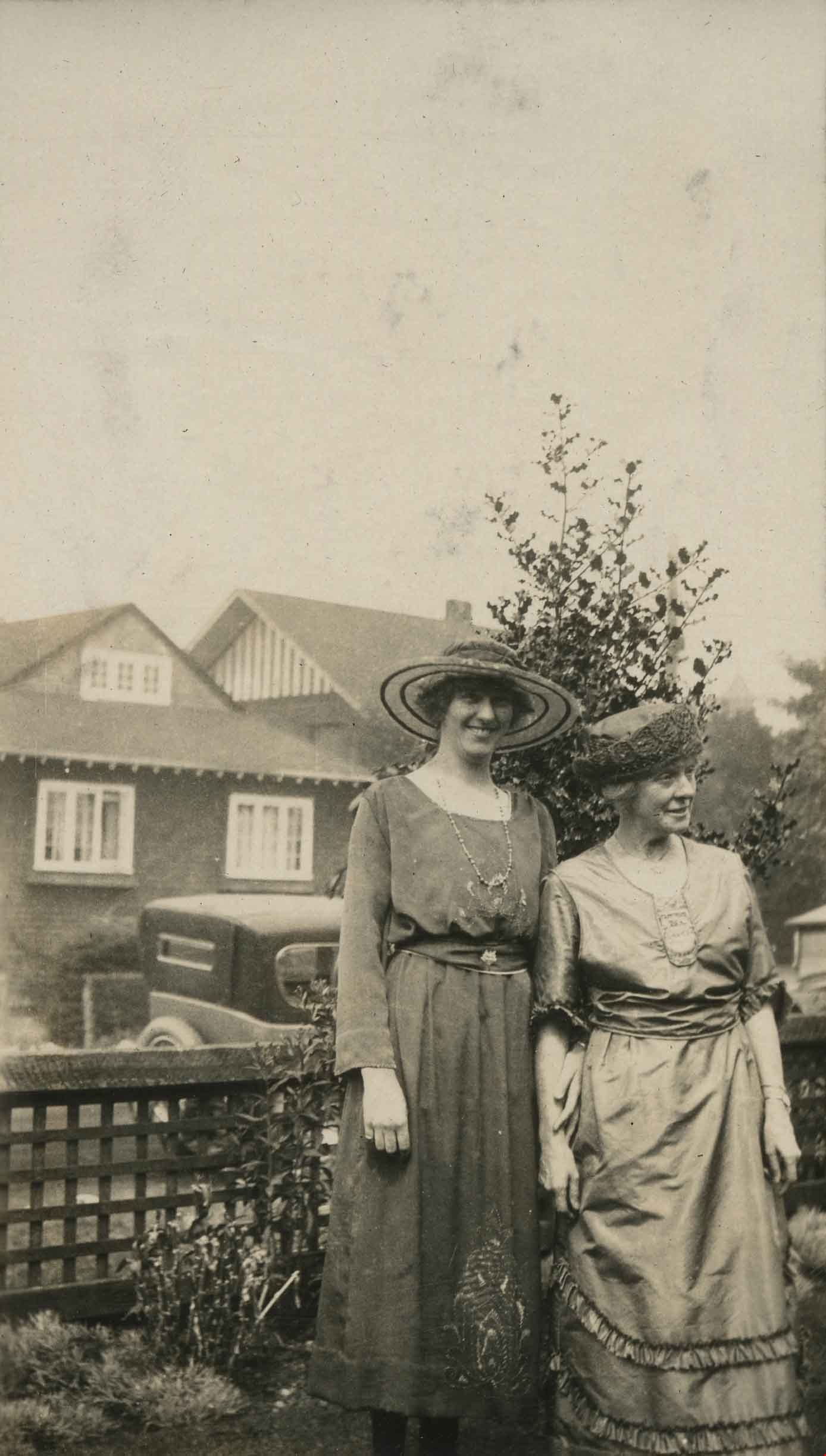
Bob, Betty and Dick Peers
https://search.heritageburnaby.ca/link/archivedescription39309
- Repository
- City of Burnaby Archives
- Date
- [192-]
- Collection/Fonds
- Peers Family and Hill Family fonds
- Description Level
- Item
- Physical Description
- 1 photograph : b&w ; 5.7 x 10 cm on page 24.5 x 32.5 cm (pasted in album)
- Scope and Content
- Photograph of three members of the Peers family outside of a house, most likely Greyfriars, the Peers family home. Bob Peers is standing to the far left, Betty Peers is in the middle and Dick Peers is to the right.
- Repository
- City of Burnaby Archives
- Date
- [192-]
- Collection/Fonds
- Peers Family and Hill Family fonds
- Physical Description
- 1 photograph : b&w ; 5.7 x 10 cm on page 24.5 x 32.5 cm (pasted in album)
- Description Level
- Item
- Record No.
- 477-628
- Access Restriction
- No restrictions
- Reproduction Restriction
- No known restrictions
- Accession Number
- 2007-12
- Scope and Content
- Photograph of three members of the Peers family outside of a house, most likely Greyfriars, the Peers family home. Bob Peers is standing to the far left, Betty Peers is in the middle and Dick Peers is to the right.
- Names
- Peers, William John "Bob"
- Freebairn-Smith, Mary Elizabeth "Betty" Peers
- Peers, Richard Dominic "Dick"
- Media Type
- Photograph
- Notes
- Title based on contents of photograph
- Geographic Access
- Rugby Street
- Street Address
- 5289 Rugby Avenue
- Historic Neighbourhood
- Burnaby Lake (Historic Neighbourhood)
- Planning Study Area
- Morley-Buckingham Area
Images
![Bob, Betty and Dick Peers, [192-] thumbnail](/media/hpo/_Data/_Archives_Images/_Unrestricted/477/477-628.jpg)

The Bride
https://search.heritageburnaby.ca/link/archivedescription39282
- Repository
- City of Burnaby Archives
- Date
- August 7, 1922
- Collection/Fonds
- Peers Family and Hill Family fonds
- Description Level
- Item
- Physical Description
- 1 photograph : b&w ; 6 x 10.4 cm on page 24.5 x 32.5 cm (pasted in album)
- Scope and Content
- Photograph of Florence Hart, on her wedding day, holding a bouquet of flowers. Florence was the daughter of Frederick and Alice Hart and she married Harold Godwin.
- Repository
- City of Burnaby Archives
- Date
- August 7, 1922
- Collection/Fonds
- Peers Family and Hill Family fonds
- Physical Description
- 1 photograph : b&w ; 6 x 10.4 cm on page 24.5 x 32.5 cm (pasted in album)
- Description Level
- Item
- Record No.
- 477-601
- Access Restriction
- No restrictions
- Reproduction Restriction
- No known restrictions
- Accession Number
- 2007-12
- Scope and Content
- Photograph of Florence Hart, on her wedding day, holding a bouquet of flowers. Florence was the daughter of Frederick and Alice Hart and she married Harold Godwin.
- Subjects
- Ceremonies - Weddings
- Names
- Godwin, Florence Hart
- Media Type
- Photograph
- Notes
- Title based on caption accompanying photograph
- Geographic Access
- Deer Lake Avenue
- Street Address
- 6664 Deer Lake Avenue
- Historic Neighbourhood
- Burnaby Lake (Historic Neighbourhood)
- Planning Study Area
- Morley-Buckingham Area
Images

The bride and her mother
https://search.heritageburnaby.ca/link/archivedescription39281
- Repository
- City of Burnaby Archives
- Date
- August 7, 1922
- Collection/Fonds
- Peers Family and Hill Family fonds
- Description Level
- Item
- Physical Description
- 1 photograph : b&w ; 6 x 10.5 cm on page 24.5 x 32.5 cm (pasted in album)
- Scope and Content
- Photograph of Florence Hart (left) and her mother, Alice Hart (right) on Florence's wedding day. Florence was the daughter of Frederick J. Hart and she married Harold Godwin. The picture was taken on the grounds of the Hart House.
- Repository
- City of Burnaby Archives
- Date
- August 7, 1922
- Collection/Fonds
- Peers Family and Hill Family fonds
- Physical Description
- 1 photograph : b&w ; 6 x 10.5 cm on page 24.5 x 32.5 cm (pasted in album)
- Description Level
- Item
- Record No.
- 477-600
- Access Restriction
- No restrictions
- Reproduction Restriction
- No known restrictions
- Accession Number
- 2007-12
- Scope and Content
- Photograph of Florence Hart (left) and her mother, Alice Hart (right) on Florence's wedding day. Florence was the daughter of Frederick J. Hart and she married Harold Godwin. The picture was taken on the grounds of the Hart House.
- Subjects
- Ceremonies - Weddings
- Media Type
- Photograph
- Notes
- Title based on caption accompanying photograph
- Geographic Access
- Deer Lake Avenue
- Street Address
- 6664 Deer Lake Avenue
- Historic Neighbourhood
- Burnaby Lake (Historic Neighbourhood)
- Planning Study Area
- Morley-Buckingham Area
Images
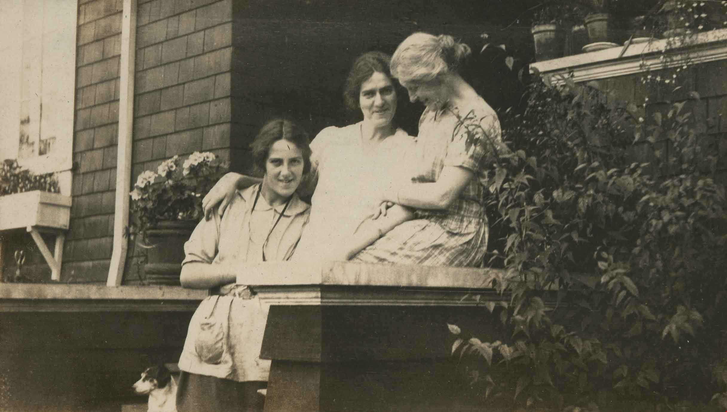
The bride with her mother and sister
https://search.heritageburnaby.ca/link/archivedescription39284
- Repository
- City of Burnaby Archives
- Date
- August 7, 1922
- Collection/Fonds
- Peers Family and Hill Family fonds
- Description Level
- Item
- Physical Description
- 1 photograph : b&w ; 6 x 10.4 cm on page 24.5 x 32.5 cm (pasted in album)
- Scope and Content
- Photograph of (l to r): Edwyna Hart, Florence Hart and Alice Hart. The photograph was taken on the occasion of Florence's wedding to Harold Godwin. The women are shown standing on some steps.
- Repository
- City of Burnaby Archives
- Date
- August 7, 1922
- Collection/Fonds
- Peers Family and Hill Family fonds
- Physical Description
- 1 photograph : b&w ; 6 x 10.4 cm on page 24.5 x 32.5 cm (pasted in album)
- Description Level
- Item
- Record No.
- 477-603
- Access Restriction
- No restrictions
- Reproduction Restriction
- No known restrictions
- Accession Number
- 2007-12
- Scope and Content
- Photograph of (l to r): Edwyna Hart, Florence Hart and Alice Hart. The photograph was taken on the occasion of Florence's wedding to Harold Godwin. The women are shown standing on some steps.
- Subjects
- Ceremonies - Weddings
- Media Type
- Photograph
- Notes
- Title based on caption accompanying photograph
- Geographic Access
- Deer Lake Avenue
- Street Address
- 6664 Deer Lake Avenue
- Historic Neighbourhood
- Burnaby Lake (Historic Neighbourhood)
- Planning Study Area
- Morley-Buckingham Area
Images

Bridge over Deer Lake Brook
https://search.heritageburnaby.ca/link/archivedescription39323
- Repository
- City of Burnaby Archives
- Date
- 1922
- Collection/Fonds
- Peers Family and Hill Family fonds
- Description Level
- Item
- Physical Description
- 1 photograph : b&w ; 6.2 x 9.8 cm on page 24.5 x 32.5 cm (pasted in album)
- Scope and Content
- Photograph of a bridge over Deer Lake Brook, covered with snow. This photograph was probably taken on the property belonging to Claude Hill, known as "Brookfield."
- Repository
- City of Burnaby Archives
- Date
- 1922
- Collection/Fonds
- Peers Family and Hill Family fonds
- Physical Description
- 1 photograph : b&w ; 6.2 x 9.8 cm on page 24.5 x 32.5 cm (pasted in album)
- Description Level
- Item
- Record No.
- 477-642
- Access Restriction
- No restrictions
- Reproduction Restriction
- No known restrictions
- Accession Number
- 2007-12
- Scope and Content
- Photograph of a bridge over Deer Lake Brook, covered with snow. This photograph was probably taken on the property belonging to Claude Hill, known as "Brookfield."
- Media Type
- Photograph
- Notes
- Title based on contents of photograph
- Geographic Access
- Deer Lake Brook
- Deer Lake Avenue
- Street Address
- 6501 Deer Lake Avenue
- Historic Neighbourhood
- Burnaby Lake (Historic Neighbourhood)
- Planning Study Area
- Morley-Buckingham Area
Images

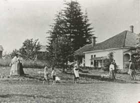
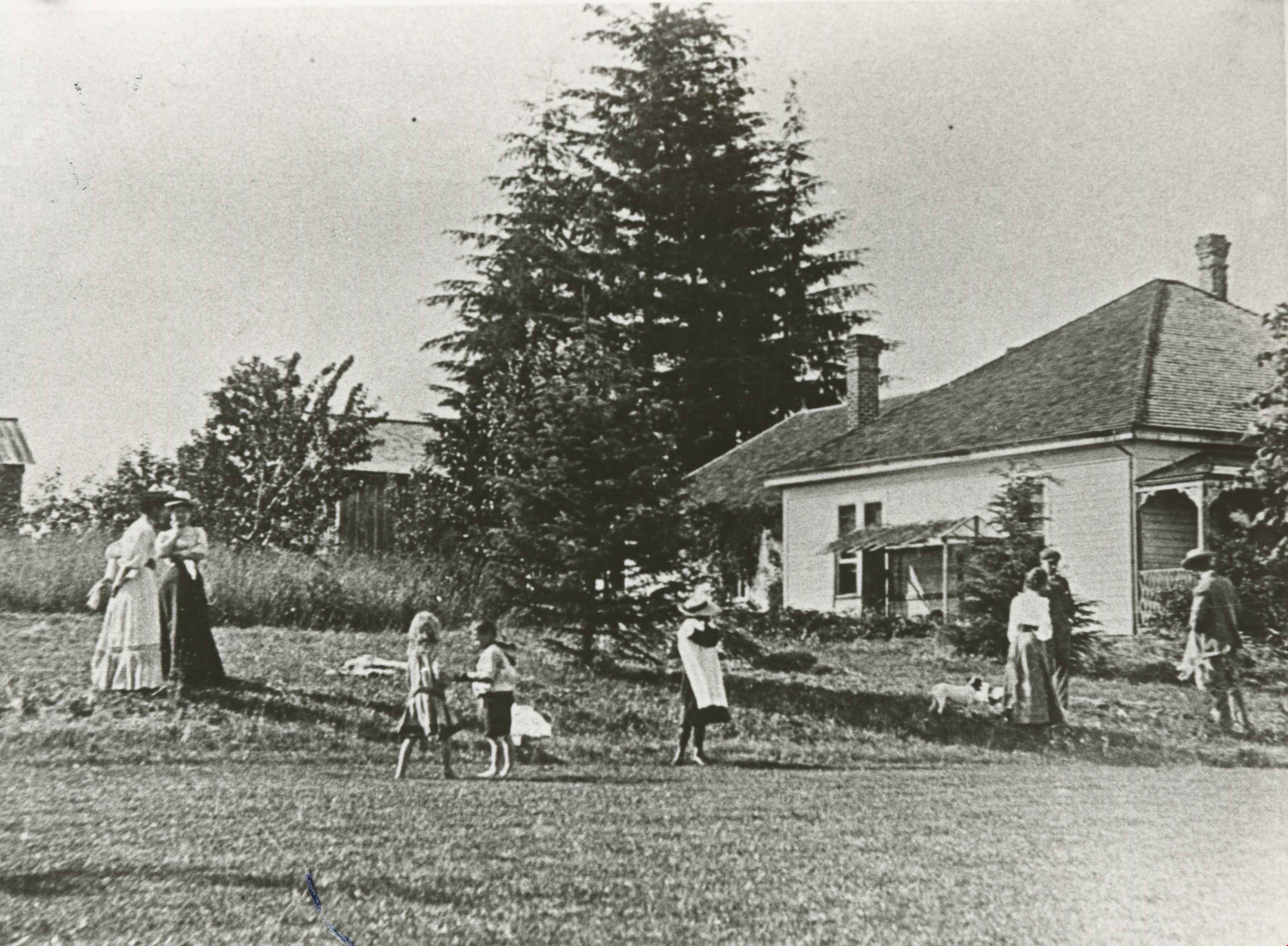
Brookfield
https://search.heritageburnaby.ca/link/archivedescription35891
- Repository
- City of Burnaby Archives
- Date
- 1923 (date of original), copied 1986
- Collection/Fonds
- Burnaby Historical Society fonds
- Description Level
- Item
- Physical Description
- 1 photograph : b&w ; 12.7 x 17.8 cm print
- Scope and Content
- Photograph of "Brookfield," the home built by Claude Hill in the Deer Lake area. Men, women and children are socializing in the yard. The property later became the site of the Burnaby Village Museum.
- Repository
- City of Burnaby Archives
- Date
- 1923 (date of original), copied 1986
- Collection/Fonds
- Burnaby Historical Society fonds
- Subseries
- Pioneer Tales subseries
- Physical Description
- 1 photograph : b&w ; 12.7 x 17.8 cm print
- Description Level
- Item
- Record No.
- 204-750
- Access Restriction
- No restrictions
- Reproduction Restriction
- No known restrictions
- Accession Number
- BHS1988-03
- Scope and Content
- Photograph of "Brookfield," the home built by Claude Hill in the Deer Lake area. Men, women and children are socializing in the yard. The property later became the site of the Burnaby Village Museum.
- Subjects
- Buildings - Residential - Houses
- Media Type
- Photograph
- Notes
- Title based on contents of photograph
- Geographic Access
- Deer Lake Avenue
- Street Address
- 6501 Deer Lake Avenue
- Historic Neighbourhood
- Burnaby Lake (Historic Neighbourhood)
- Planning Study Area
- Morley-Buckingham Area
Images

Burnaby Civic Employees Union Memorial Fountain
https://search.heritageburnaby.ca/link/landmark539
- Repository
- Burnaby Heritage Planning
- Description
- This memorial granite drinking fountain is a monument to Burnaby’s municipal employees who lost their lives in the First World War. It has been relocated from its original setting to a shaded arterial pathway within the Burnaby Village Museum.
- Associated Dates
- 1923
- Formal Recognition
- Heritage Designation, Community Heritage Register
- Repository
- Burnaby Heritage Planning
- Geographic Access
- Deer Lake Avenue
- Associated Dates
- 1923
- Formal Recognition
- Heritage Designation, Community Heritage Register
- Enactment Type
- Bylaw No. 9807
- Enactment Date
- 23/11/1992
- Description
- This memorial granite drinking fountain is a monument to Burnaby’s municipal employees who lost their lives in the First World War. It has been relocated from its original setting to a shaded arterial pathway within the Burnaby Village Museum.
- Heritage Value
- The fountain is an early civic monument with superior massing and detail, constructed of local materials by local stonemason William Williamson. It was erected by the Burnaby Civic Employees Union (now CUPE Local 23) in 1923, on Burnaby’s original Municipal Hall grounds located at Kingsway and Edmonds Street, to honour their members who lost their lives in the First World War, commemorated by an engraved memorial at the top of the fountain. It signifies an important connection with the early strength and prominence of the civic labour union in Burnaby, as this was a memorial erected by the union members themselves, rather than by the civic government. Many war memorials were constructed across Canada after the end of the First World War, however, most are static, inviting passive contemplation. This memorial is unusual in its combination of functions; its use as a drinking fountain invites active participation. The memorial also includes a stone drinking bowl for dogs at the bottom left of the memorial, further illustrating the daily functional use of the fountain. The heritage value for this fountain also lies in its interpretive value within the Burnaby Village Museum. The site is an important cultural feature for the interpretation of Burnaby’s heritage to the public. The fountain was moved to the Burnaby Village Museum in 1974.
- Defining Elements
- The character defining features of the Burnaby Civic Employees Union Memorial Fountain include its: - distinctive form with central water fountain - construction of rough-dressed local B.C. granite - engraved memorial at the top - carved emblematic maple leaf - drinking fountain function - dog drinking bowl
- Locality
- Deer Lake Park
- Historic Neighbourhood
- Burnaby Lake (Historic Neighbourhood)
- Planning Study Area
- Morley-Buckingham Area
- Builder
- William Williamson
- Function
- Primary Current--Monument
- Primary Historic--Monument
- Secondary Current--Museum
- Community
- Burnaby
- Cadastral Identifier
- P.I.D. No. 011-030-356 Legal Description: Parcel 1, District Lot 79 and District Lot 85, Group 1, New Westminster District, Reference Plan 77594
- Boundaries
- Burnaby Village Museum is comprised of a single municipally-owned property located at 6501 Deer Lake Avenue, Burnaby.
- Area
- 38,488.63
- Contributing Resource
- Building
- Structure
- Landscape Feature
- Ownership
- Public (local)
- Documentation
- Heritage Site Files: PC77000 20. City of Burnaby Planning and Building Department, 4949 Canada Way, Burnaby, B.C., V5G 1M2
- Street Address
- 6501 Deer Lake Avenue
Images


![Burnaby Fire Department rescue truck, [after 1976] thumbnail](/media/hpo/_Data/_BVM_Images/2000/200200100005.jpg?width=280)
Burnaby Fire Department rescue truck
https://search.heritageburnaby.ca/link/museumdescription1607
- Repository
- Burnaby Village Museum
- Date
- [after 1976]
- Collection/Fonds
- Burnaby Village Museum Photograph collection
- Description Level
- Item
- Physical Description
- 1 photograph : b&w ; 20.5 x 25.2 cm
- Scope and Content
- Photograph of four unidentified firemen gathered beside Burnaby Fire Department's Rescue 1 truck (1976 Ford C 600 Rescue unit). The truck's side compartments are visible, housing fire extinguishers and other equipment. The truck appears to be parked at fire hall no. 1 at Sperling and Canada Way.
- Repository
- Burnaby Village Museum
- Collection/Fonds
- Burnaby Village Museum Photograph collection
- Description Level
- Item
- Physical Description
- 1 photograph : b&w ; 20.5 x 25.2 cm
- Scope and Content
- Photograph of four unidentified firemen gathered beside Burnaby Fire Department's Rescue 1 truck (1976 Ford C 600 Rescue unit). The truck's side compartments are visible, housing fire extinguishers and other equipment. The truck appears to be parked at fire hall no. 1 at Sperling and Canada Way.
- Names
- Burnaby Fire Department
- Geographic Access
- Canada Way
- Sperling Avenue
- Accession Code
- BV002.10.5
- Access Restriction
- Restricted access
- Reproduction Restriction
- May be restricted by third party rights
- Date
- [after 1976]
- Media Type
- Photograph
- Historic Neighbourhood
- Burnaby Lake (Historic Neighbourhood)
- Planning Study Area
- Morley-Buckingham Area
- Related Material
- For another photograph of the rescue truck taken from a different angle, see BV002.10.4
- Scan Resolution
- 600
- Scan Date
- 09-Jun-09
- Scale
- 100
- Notes
- Title based on contents of photograph
Images
![Burnaby Fire Department rescue truck, [after 1976] thumbnail](/media/hpo/_Data/_BVM_Images/2000/200200100005.jpg)

Burnaby Lake Neighbourhood
https://search.heritageburnaby.ca/link/landmark755
- Repository
- Burnaby Heritage Planning
- Associated Dates
- 1905-1924
- Heritage Value
- Along with logging and sawmills, Burnaby became known as a prime agricultural area and the Burnaby Lake Neighbourhood saw the development of many vegetable and fruit farms. Growers in the Burnaby and Deer Lake districts took their produce to the tram line on Edmonds Street and shipped it to markets in New Westminster and Vancouver on a specially designed interurban freight car that was open-sided for easy loading. The car's canvas curtains which sometimes came loose and flapped like wings in the wind led people to dub it "the flying dutchman." Most Burnaby fruit and vegetable growers depended on seasonal Chinese work forces and other local Chinese farm residents to oversee operations; these workers being recruited from New Westminsters' Asian community. Besides being good farmers, Burnaby Lake's early residents fostered a strong sense of community. Both L. Claude Hill and his brother Bernard were elected to Burnaby Municipal council and Bernard was the one who knocked on doors to find enough children to meet the qualifications for establishing a school in the district.
- Historic Neighbourhood
- Burnaby Lake (Historic Neighbourhood)
- Planning Study Area
- Morley-Buckingham Area
- Lakeview-Mayfield Area
Images
