Narrow Results By

Barnet Wagon Road
https://search.heritageburnaby.ca/link/archivedescription38306
- Repository
- City of Burnaby Archives
- Date
- June 1903 (date of original), copied ca. 1990
- Collection/Fonds
- Burnaby Historical Society fonds
- Description Level
- Item
- Physical Description
- 1 photograph : b&w ; 10 x 15 cm print
- Scope and Content
- Photograph of the Barnet Wagon Road looking west from Sperling Avenue.
- Repository
- City of Burnaby Archives
- Date
- June 1903 (date of original), copied ca. 1990
- Collection/Fonds
- Burnaby Historical Society fonds
- Subseries
- Photographs subseries
- Physical Description
- 1 photograph : b&w ; 10 x 15 cm print
- Description Level
- Item
- Record No.
- 403-001
- Access Restriction
- No restrictions
- Reproduction Restriction
- No known restrictions
- Accession Number
- BHS2007-04
- Scope and Content
- Photograph of the Barnet Wagon Road looking west from Sperling Avenue.
- Subjects
- Land Clearing
- Geographic Features - Roads
- Media Type
- Photograph
- Notes
- Title based on contents of photograph
- Geographic Access
- Barnet Road
- Sperling Avenue
- Historic Neighbourhood
- Lochdale (Historic Neighbourhood)
- Planning Study Area
- Westridge Area
Images

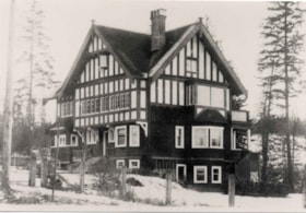
Gavin house
https://search.heritageburnaby.ca/link/archivedescription36002
- Repository
- City of Burnaby Archives
- Date
- 1912
- Collection/Fonds
- Burnaby Historical Society fonds
- Description Level
- Item
- Physical Description
- 1 photograph : b&w ; 8.5 x 12.5 cm print
- Scope and Content
- Photograph of the Gavin house located on Buckingham Road at Sperling. The house was designed by architect A.C. Hope and built for Francis John Gavin and his family.
- Repository
- City of Burnaby Archives
- Date
- 1912
- Collection/Fonds
- Burnaby Historical Society fonds
- Subseries
- Gavin family subseries
- Physical Description
- 1 photograph : b&w ; 8.5 x 12.5 cm print
- Description Level
- Item
- Record No.
- 209-001
- Access Restriction
- No restrictions
- Reproduction Restriction
- No known restrictions
- Accession Number
- BHS1988-09
- Scope and Content
- Photograph of the Gavin house located on Buckingham Road at Sperling. The house was designed by architect A.C. Hope and built for Francis John Gavin and his family.
- Subjects
- Buildings - Residential - Houses
- Media Type
- Photograph
- Notes
- Title based on contents of photograph
- Geographic Access
- Buckingham Avenue
- Sperling Avenue
- Historic Neighbourhood
- Lochdale (Historic Neighbourhood)
- Planning Study Area
- Sperling-Broadway Area
Images

![In front of Duthie School, [between 1911 and 1919] thumbnail](/media/hpo/_Data/_Archives_Images/_Unrestricted/316/325-031.jpg?width=280)
In front of Duthie School
https://search.heritageburnaby.ca/link/archivedescription37159
- Repository
- City of Burnaby Archives
- Date
- [between 1911 and 1919]
- Collection/Fonds
- Burnaby Historical Society fonds
- Description Level
- Item
- Physical Description
- 1 photograph : b&w ; 12.5 x 8 cm print
- Scope and Content
- Photograph of a man with surveyor equipment sitting on the wooden sidewalk in front of Duthie School (also called Johnston Road School). This school existed from 1909 to 1921.
- Repository
- City of Burnaby Archives
- Date
- [between 1911 and 1919]
- Collection/Fonds
- Burnaby Historical Society fonds
- Subseries
- Disney family subseries
- Physical Description
- 1 photograph : b&w ; 12.5 x 8 cm print
- Description Level
- Item
- Record No.
- 325-031
- Access Restriction
- No restrictions
- Reproduction Restriction
- No known restrictions
- Accession Number
- BHS1996-04
- Scope and Content
- Photograph of a man with surveyor equipment sitting on the wooden sidewalk in front of Duthie School (also called Johnston Road School). This school existed from 1909 to 1921.
- Subjects
- Buildings - Schools
- Names
- Duthie School
- Media Type
- Photograph
- Photographer
- Disney, John Harold "Jack"
- Notes
- Title based on contents of photograph
- Geographic Access
- Broadway
- Sperling Avenue
- Historic Neighbourhood
- Lochdale (Historic Neighbourhood)
- Planning Study Area
- Sperling-Broadway Area
Images
![In front of Duthie School, [between 1911 and 1919] thumbnail](/media/hpo/_Data/_Archives_Images/_Unrestricted/316/325-031.jpg)
![Johnston Road School, [between 1911 and 1919] thumbnail](/media/hpo/_Data/_Archives_Images/_Unrestricted/316/325-030.jpg?width=280)
Johnston Road School
https://search.heritageburnaby.ca/link/archivedescription37158
- Repository
- City of Burnaby Archives
- Date
- [between 1911 and 1919]
- Collection/Fonds
- Burnaby Historical Society fonds
- Description Level
- Item
- Physical Description
- 1 photograph : b&w ; 7.5 x 12.5 cm print
- Scope and Content
- Photograph of Johnston Road School (also called Duthie School) taken from Broadway. This school existed from 1909 to 1921.
- Repository
- City of Burnaby Archives
- Date
- [between 1911 and 1919]
- Collection/Fonds
- Burnaby Historical Society fonds
- Subseries
- Disney family subseries
- Physical Description
- 1 photograph : b&w ; 7.5 x 12.5 cm print
- Description Level
- Item
- Record No.
- 325-030
- Access Restriction
- No restrictions
- Reproduction Restriction
- No known restrictions
- Accession Number
- BHS1996-04
- Scope and Content
- Photograph of Johnston Road School (also called Duthie School) taken from Broadway. This school existed from 1909 to 1921.
- Subjects
- Buildings - Schools
- Media Type
- Photograph
- Photographer
- Disney, John Harold "Jack"
- Notes
- Title based on contents of photograph
- Geographic Access
- Broadway
- Sperling Avenue
- Historic Neighbourhood
- Lochdale (Historic Neighbourhood)
- Planning Study Area
- Sperling-Broadway Area
Images
![Johnston Road School, [between 1911 and 1919] thumbnail](/media/hpo/_Data/_Archives_Images/_Unrestricted/316/325-030.jpg)
![Logging Camp, [1903] thumbnail](/media/hpo/_Data/_BVM_Images/1977/1977_0140_0004_001.jpg?width=280)
Logging Camp
https://search.heritageburnaby.ca/link/museumdescription639
- Repository
- Burnaby Village Museum
- Date
- [1903]
- Collection/Fonds
- Burnaby Village Museum Photograph collection
- Description Level
- Item
- Physical Description
- 1 photograph : b&w ; 11.5 x 17.5 cm mounted on card 18.5 x 23 cm
- Scope and Content
- Photograph of a crew of loggers sitting and standing in front of their cabins at a logging camp at Broadway, west of Sperling Avenue. Robert Pontifex is standing fourth from the right.
- Repository
- Burnaby Village Museum
- Collection/Fonds
- Burnaby Village Museum Photograph collection
- Description Level
- Item
- Physical Description
- 1 photograph : b&w ; 11.5 x 17.5 cm mounted on card 18.5 x 23 cm
- Scope and Content
- Photograph of a crew of loggers sitting and standing in front of their cabins at a logging camp at Broadway, west of Sperling Avenue. Robert Pontifex is standing fourth from the right.
- Subjects
- Occupations - Lumberjacks
- Names
- Pontifex, Robert
- Geographic Access
- Broadway
- Sperling Avenue
- Accession Code
- HV977.140.4
- Access Restriction
- No restrictions
- Date
- [1903]
- Media Type
- Photograph
- Historic Neighbourhood
- Lochdale (Historic Neighbourhood)
- Planning Study Area
- Sperling-Broadway Area
- Scan Resolution
- 600
- Scan Date
- 2023-07-25
- Notes
- Title based on contents of photograph
- Handwritten notes on verso of card mount read: "Broadway West of Sperling Ave / 1903" and "Mr. Doug Lorky."
Images
![Logging Camp, [1903] thumbnail](/media/hpo/_Data/_BVM_Images/1977/1977_0140_0004_001.jpg)


Sperling Avenue and Barnet Road
https://search.heritageburnaby.ca/link/archivedescription35442
- Repository
- City of Burnaby Archives
- Date
- 1915 (date of original), copied 1986
- Collection/Fonds
- Burnaby Historical Society fonds
- Description Level
- Item
- Physical Description
- 1 photograph : b&w ; 12.7 x 17.8 cm print
- Scope and Content
- Photograph of a Cadillac full of passengers driving along the plank roadway at Sperling Avenue and Barnet Road.
- Repository
- City of Burnaby Archives
- Date
- 1915 (date of original), copied 1986
- Collection/Fonds
- Burnaby Historical Society fonds
- Subseries
- Pioneer Tales subseries
- Physical Description
- 1 photograph : b&w ; 12.7 x 17.8 cm print
- Description Level
- Item
- Record No.
- 204-300
- Access Restriction
- No restrictions
- Reproduction Restriction
- No restrictions
- Accession Number
- BHS1988-03
- Scope and Content
- Photograph of a Cadillac full of passengers driving along the plank roadway at Sperling Avenue and Barnet Road.
- Media Type
- Photograph
- Photographer
- Eaton, Dr. Carl
- Notes
- Title based on contents of photograph
- Photograph is believed to be taken by Dr. Carl Eaton
- Geographic Access
- Sperling Avenue
- Barnet Road
- Historic Neighbourhood
- Lochdale (Historic Neighbourhood)
- Planning Study Area
- Westridge Area
Images


Sperling Avenue School
https://search.heritageburnaby.ca/link/landmark744
- Repository
- Burnaby Heritage Planning
- Geographic Access
- Sperling Avenue
- Associated Dates
- 1914
- Heritage Value
- The Sperling Avenue School was opened in 1914 to service the growing community around the B.C. Electric Company's Pole Line Road (Sperling Avenue). This school replaced the one-room Duthie schoolhouse.
- Historic Neighbourhood
- Lochdale (Historic Neighbourhood)
- Planning Study Area
- Sperling-Broadway Area
- Street Address
- 2200 Sperling Avenue
- Street View URL
- Google Maps Street View
Images

Sperling Avenue School during construction
https://search.heritageburnaby.ca/link/archivedescription36027
- Repository
- City of Burnaby Archives
- Date
- 1913
- Collection/Fonds
- Burnaby Historical Society fonds
- Description Level
- Item
- Physical Description
- 1 photograph : sepia
- Scope and Content
- Photograph of the Sperling Avenue School during construction. This was the first school ever built by Bruce Patterson.
- Repository
- City of Burnaby Archives
- Date
- 1913
- Collection/Fonds
- Burnaby Historical Society fonds
- Subseries
- Patterson family subseries
- Physical Description
- 1 photograph : sepia
- Description Level
- Item
- Record No.
- 213-009
- Access Restriction
- No restrictions
- Reproduction Restriction
- No known restrictions
- Accession Number
- BHS1988-13
- Scope and Content
- Photograph of the Sperling Avenue School during construction. This was the first school ever built by Bruce Patterson.
- Media Type
- Photograph
- Notes
- Title based on contents of photograph
- Hand written note on verso of photograph reads: "1st School Bruce built"
- Geographic Access
- Sperling Avenue
- Street Address
- 2200 Sperling Avenue
- Historic Neighbourhood
- Lochdale (Historic Neighbourhood)
- Planning Study Area
- Sperling-Broadway Area
Images

Sperling Avenue School site
https://search.heritageburnaby.ca/link/museumdescription11137
- Repository
- Burnaby Village Museum
- Date
- March 8, 1915
- Collection/Fonds
- Ronald G. Scobbie collection
- Description Level
- Item
- Physical Description
- 1 survey plan : blueprint on paper ; 56 x 54 cm
- Scope and Content
- Survey plan of "Sperling Avenue School Site / Burnaby Municipality" "Being a 4.11 acre portion of the south half of Block 7 of subd. part of Lot 131, Grroup 1" "New Westminster District".
- Repository
- Burnaby Village Museum
- Collection/Fonds
- Ronald G. Scobbie collection
- Description Level
- Item
- Physical Description
- 1 survey plan : blueprint on paper ; 56 x 54 cm
- Material Details
- Scale 40 feet = 1 inch
- Scope and Content
- Survey plan of "Sperling Avenue School Site / Burnaby Municipality" "Being a 4.11 acre portion of the south half of Block 7 of subd. part of Lot 131, Grroup 1" "New Westminster District".
- Creator
- McGugan, Donald Johnston
- Subjects
- Buildings - Schools
- Names
- Sperling Avenue School
- Responsibility
- Burnett & McGugan, Engineers and Surveyors
- Geographic Access
- Sperling Avenue
- Street Address
- 2200 Sperling Avenue
- Accession Code
- BV003.83.16
- Access Restriction
- No restrictions
- Reproduction Restriction
- No known restrictions
- Date
- March 8, 1915
- Media Type
- Cartographic Material
- Historic Neighbourhood
- Lochdale (Historic Neighbourhood)
- Planning Study Area
- Sperling-Broadway Area
- Scan Resolution
- 440
- Scan Date
- 22-Dec-2020
- Scale
- 100
- Notes
- Title based on contents of plan
- handwritten on back, "1748"
- Oath on plan reads: "I, D.G. McGugan..." "...person- ally superintend the survey..." "...completed on the 8th day of March 1915"; signed by D.J. McGugan, notarized by "R.E. Chapman", sworn "...12th day of April 1915" "Burnett and McGugan" "B.C. Land Surveyors Etc. New Westminster, B.C..";
Images
