Narrow Results By
Subject
- Accidents 2
- Advertising Medium - Signs and Signboards 11
- Aerial Photographs 4
- Agricultural Tools and Equipment - Cultivators 1
- Agricultural Tools and Equipment - Gardening Equipment 1
- Agriculture - Farms 3
- Agriculture - Poultry 1
- Animals - Dogs 1
- Animals - Horses 3
- Buildings - Agricultural - Barns 3
- Buildings - Commercial 1
- Buildings - Commercial - General Stores 1
Creator
- Bartel, Mario 17
- Battistoni, Peter 3
- Bellinger, Bernard 2
- Born, A. J. 19
- British Columbia Underwriters' Association 1
- Burnett & McGugan, Engineers and Surveyors 1
- Chapman, Fred 1
- Commercial Illustrators Industrial Photographers 1
- Disney, John Harold "Jack" 2
- Eaton, Dr. Carl 1
- Harrison, Jim 2
- Hodge, Craig 1
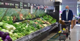
Mayor Hurley in Super Valu
https://search.heritageburnaby.ca/link/museumdescription15366
- Repository
- Burnaby Village Museum
- Date
- 6 May 2020
- Collection/Fonds
- Burnaby Village Museum COVID-19 collection
- Description Level
- Item
- Physical Description
- 1 photograph (jpg)
- Scope and Content
- Photograph of a Burnaby Mayor Mike Hurley pushing a shopping cart in the produce section of the Super Valu grocery store on Burnwood Drive in Burnaby. The mayor is wearing a disposable face mask.
- Repository
- Burnaby Village Museum
- Collection/Fonds
- Burnaby Village Museum COVID-19 collection
- Description Level
- Item
- Physical Description
- 1 photograph (jpg)
- Scope and Content
- Photograph of a Burnaby Mayor Mike Hurley pushing a shopping cart in the produce section of the Super Valu grocery store on Burnwood Drive in Burnaby. The mayor is wearing a disposable face mask.
- Names
- Super Valu
- Hurley, Mike
- Geographic Access
- Burnwood Drive
- Street Address
- 1601 Burnwood Drive
- Accession Code
- BV021.2.28
- Access Restriction
- No restrictions
- Reproduction Restriction
- May be restricted by third party rights
- Date
- 6 May 2020
- Media Type
- Photograph
- Historic Neighbourhood
- Lochdale (Historic Neighbourhood)
- Planning Study Area
- Sperling-Broadway Area
- Notes
- Title based on contents of photograph
Images

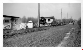
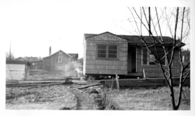
Moving the house on Winch Street
https://search.heritageburnaby.ca/link/museumdescription15054
- Repository
- Burnaby Village Museum
- Date
- 19 Mar. 1948
- Collection/Fonds
- Elmer Wilson Martin fonds
- Description Level
- Item
- Physical Description
- 1 photograph : b&w ; 7 x 11.5 cm
- Scope and Content
- Photograph of Wilbert "Bert" Martin's house being moved on a truck from 6776 Winch Street. The house was moved to 6656 Winch Street.
- Repository
- Burnaby Village Museum
- Collection/Fonds
- Elmer Wilson Martin fonds
- Description Level
- Item
- Physical Description
- 1 photograph : b&w ; 7 x 11.5 cm
- Scope and Content
- Photograph of Wilbert "Bert" Martin's house being moved on a truck from 6776 Winch Street. The house was moved to 6656 Winch Street.
- Geographic Access
- Winch Street
- Accession Code
- BV019.37.29
- Access Restriction
- No restrictions
- Reproduction Restriction
- No known restrictions
- Date
- 19 Mar. 1948
- Media Type
- Photograph
- Historic Neighbourhood
- Lochdale (Historic Neighbourhood)
- Planning Study Area
- Lochdale Area
- Scan Resolution
- 600
- Scan Date
- February 4, 2021
- Scale
- 100
- Notes
- Title based on contents of photograph
- Note in blue ink on verso of photograph reads: "Moving the house / March 19th 1948"
- Stamp in black ink on verso of photograph reads: "629"
Images

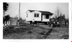
Moving the house on Winch Street
https://search.heritageburnaby.ca/link/museumdescription15055
- Repository
- Burnaby Village Museum
- Date
- 19 Mar. 1948
- Collection/Fonds
- Elmer Wilson Martin fonds
- Description Level
- Item
- Physical Description
- 1 photograph : b&w ; 7 x 11.5 cm
- Scope and Content
- Photograph of Wilbert "Bert" Martin's house being moved on a truck from 6776 Winch Street. The house was moved to 6656 Winch Street.
- Repository
- Burnaby Village Museum
- Collection/Fonds
- Elmer Wilson Martin fonds
- Description Level
- Item
- Physical Description
- 1 photograph : b&w ; 7 x 11.5 cm
- Scope and Content
- Photograph of Wilbert "Bert" Martin's house being moved on a truck from 6776 Winch Street. The house was moved to 6656 Winch Street.
- Geographic Access
- Winch Street
- Accession Code
- BV019.37.30
- Access Restriction
- No restrictions
- Reproduction Restriction
- No known restrictions
- Date
- 19 Mar. 1948
- Media Type
- Photograph
- Historic Neighbourhood
- Lochdale (Historic Neighbourhood)
- Planning Study Area
- Lochdale Area
- Scan Resolution
- 600
- Scan Date
- February 4, 2021
- Scale
- 100
- Notes
- Title based on contents of photograph
- Note in blue ink on verso of photograph reads: "Moving the house / March 19th 1948"
- Stamp in black ink on verso of photograph reads: "629"
Images

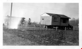
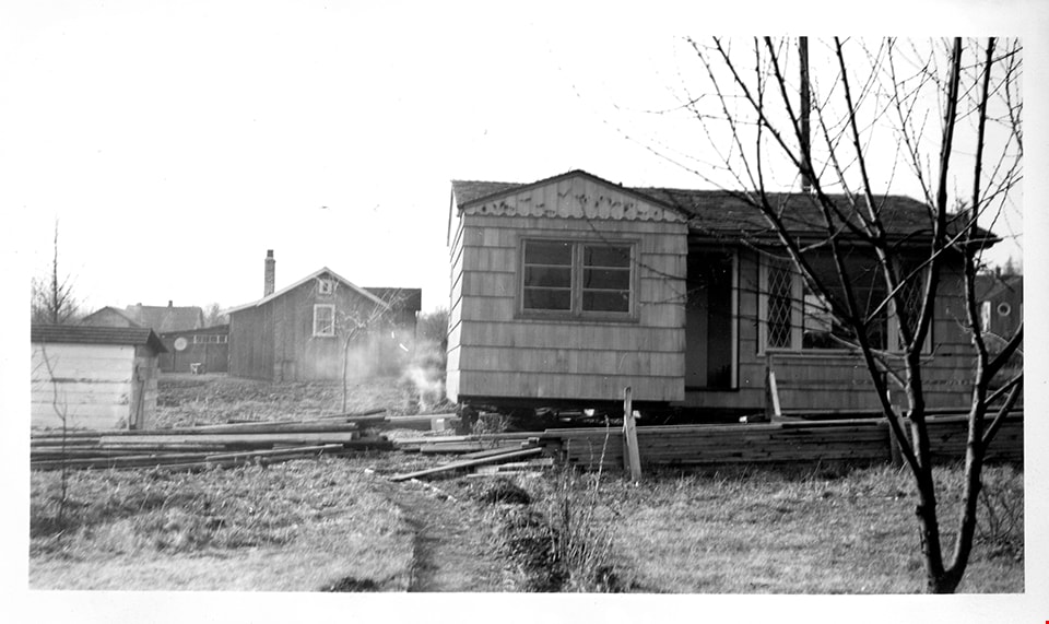
Moving the house on Winch Street
https://search.heritageburnaby.ca/link/museumdescription15056
- Repository
- Burnaby Village Museum
- Date
- 19 Mar. 1948
- Collection/Fonds
- Elmer Wilson Martin fonds
- Description Level
- Item
- Physical Description
- 1 photograph : b&w ; 7 x 11.5 cm
- Scope and Content
- Photograph of Wilbert "Bert" Martin's house being moved on a flatbed truck from 6776 Winch Street. The house was moved to 6656 Winch Street. Wilbert "Bert" Martin and his father, William Henry Martin on standing on the site near the house. A jeep is parked in front of the house.
- Repository
- Burnaby Village Museum
- Collection/Fonds
- Elmer Wilson Martin fonds
- Description Level
- Item
- Physical Description
- 1 photograph : b&w ; 7 x 11.5 cm
- Scope and Content
- Photograph of Wilbert "Bert" Martin's house being moved on a flatbed truck from 6776 Winch Street. The house was moved to 6656 Winch Street. Wilbert "Bert" Martin and his father, William Henry Martin on standing on the site near the house. A jeep is parked in front of the house.
- Geographic Access
- Winch Street
- Accession Code
- BV019.37.31
- Access Restriction
- No restrictions
- Reproduction Restriction
- No known restrictions
- Date
- 19 Mar. 1948
- Media Type
- Photograph
- Historic Neighbourhood
- Lochdale (Historic Neighbourhood)
- Planning Study Area
- Lochdale Area
- Scan Resolution
- 600
- Scan Date
- February 4, 2021
- Scale
- 100
- Notes
- Title based on contents of photograph
- Note in blue ink on verso of photograph reads: "Bert & Dad / March 19th 1948"
- Stamp in black ink on verso of photograph reads: "629"
Images

Moving the house on Winch Street
https://search.heritageburnaby.ca/link/museumdescription15057
- Repository
- Burnaby Village Museum
- Date
- 11 Jan. 1948
- Collection/Fonds
- Elmer Wilson Martin fonds
- Description Level
- Item
- Physical Description
- 1 photograph : b&w ; 7 x 11.5 cm
- Scope and Content
- Photograph of Wilbert "Bert" Martin's house being prepared to be moved from 6776 Winch Street. The house was moved to 6656 Winch Street. The house is being jacked up in preparation for the move.
- Repository
- Burnaby Village Museum
- Collection/Fonds
- Elmer Wilson Martin fonds
- Description Level
- Item
- Physical Description
- 1 photograph : b&w ; 7 x 11.5 cm
- Scope and Content
- Photograph of Wilbert "Bert" Martin's house being prepared to be moved from 6776 Winch Street. The house was moved to 6656 Winch Street. The house is being jacked up in preparation for the move.
- Subjects
- Buildings - Residential - Houses
- Geographic Access
- Winch Street
- Accession Code
- BV019.37.32
- Access Restriction
- No restrictions
- Reproduction Restriction
- No known restrictions
- Date
- 11 Jan. 1948
- Media Type
- Photograph
- Historic Neighbourhood
- Lochdale (Historic Neighbourhood)
- Planning Study Area
- Lochdale Area
- Scan Resolution
- 600
- Scan Date
- February 4, 2021
- Scale
- 100
- Notes
- Title based on contents of photograph
- Note in blue ink on verso of photograph reads: "Bert's house, Winch St. / Jan. 11th 1948"
- Stamp in black ink on verso of photograph reads: "629"
Images

Municipality of Burnaby - Volume XV and Volume XVIII
https://search.heritageburnaby.ca/link/museumdescription8680
- Repository
- Burnaby Village Museum
- Date
- May 1927
- Collection/Fonds
- Burnaby Village Museum Map collection
- Description Level
- File
- Physical Description
- 4 plans on 4 sheets : col. lithographic prints ; 63.5 x 53.5 cm folded to 53 x 31.5 cm
- Scope and Content
- File consists of four pages of plans removed from a bound book containing a series of fire insurance plans of the Municipality of Burnaby. The first two pages are numbered "A" and "B" and are key plans from "GREATER VANCOUVER B.C. / VOLUME XV / Surveyed _ May 1927 / MUNICIPALITY OF / BURNABY", "PLA…
- Repository
- Burnaby Village Museum
- Collection/Fonds
- Burnaby Village Museum Map collection
- Description Level
- File
- Physical Description
- 4 plans on 4 sheets : col. lithographic prints ; 63.5 x 53.5 cm folded to 53 x 31.5 cm
- Material Details
- Scales [1:1200] and [1:6000]
- Scope and Content
- File consists of four pages of plans removed from a bound book containing a series of fire insurance plans of the Municipality of Burnaby. The first two pages are numbered "A" and "B" and are key plans from "GREATER VANCOUVER B.C. / VOLUME XV / Surveyed _ May 1927 / MUNICIPALITY OF / BURNABY", "PLAN DEPT. FIRE BRANCH _ B.C. INSURANCE UNDERWRITERS ASSN.". Key Plan "B" covers plans: 1505; 1506; 1512 to 1516; 1540 to 1544; 1550 to 1557 and District Lots: 129 to 132; 135 to 138; 205 to 208 and 215 to 218. Key Plan "A" covers plans: 1501 to 1504; 1507 to 1511; 1517 to 1525; 1531 to 1539; 1545 to 1550 and District Lots: 116 to 127 and 186 to 189. Plan "1806" is part of "GREATER VANCOUVER B.C. / VOLUME XVIII / Municipality of Burnaby / May, 1927" and covers District Lot 153. Plan "1807" is from "GREATER VANCOUVER B.C. / VOLUME XVIII / Municipality of Burnaby / May, 1927" and covers District Lots: 99,149 and 152.
- Responsibility
- British Columbia Underwriters' Association
- Accession Code
- HV972.111.2
- Access Restriction
- No restrictions
- Reproduction Restriction
- May be restricted by third party rights
- Date
- May 1927
- Media Type
- Cartographic Material
- Historic Neighbourhood
- Vancouver Heights (Historic Neighbourhood)
- Lochdale (Historic Neighbourhood)
- Capitol Hill (Historic Neighbourhood)
- Central Park (Historic Neighbourhood)
- Alta Vista (Historic Neighbourhood)
- Planning Study Area
- Burnaby Heights Area
- Sperling-Broadway Area
- Lochdale Area
- Parkcrest-Aubrey Area
- Westridge Area
- Willingdon Heights Area
- Capitol Hill Area
- Maywood Area
- Marlborough Area
- Scan Resolution
- 400
- Scan Date
- 2021-11-18
- Notes
- Title based on content of plans
- Scales are measured 1 inch = 100 feet and 1 inch = 500 feet
- See also BV987.1.70d for revised versions of plans
Zoomable Images


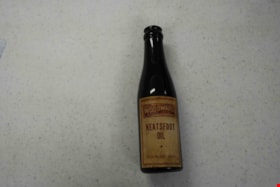
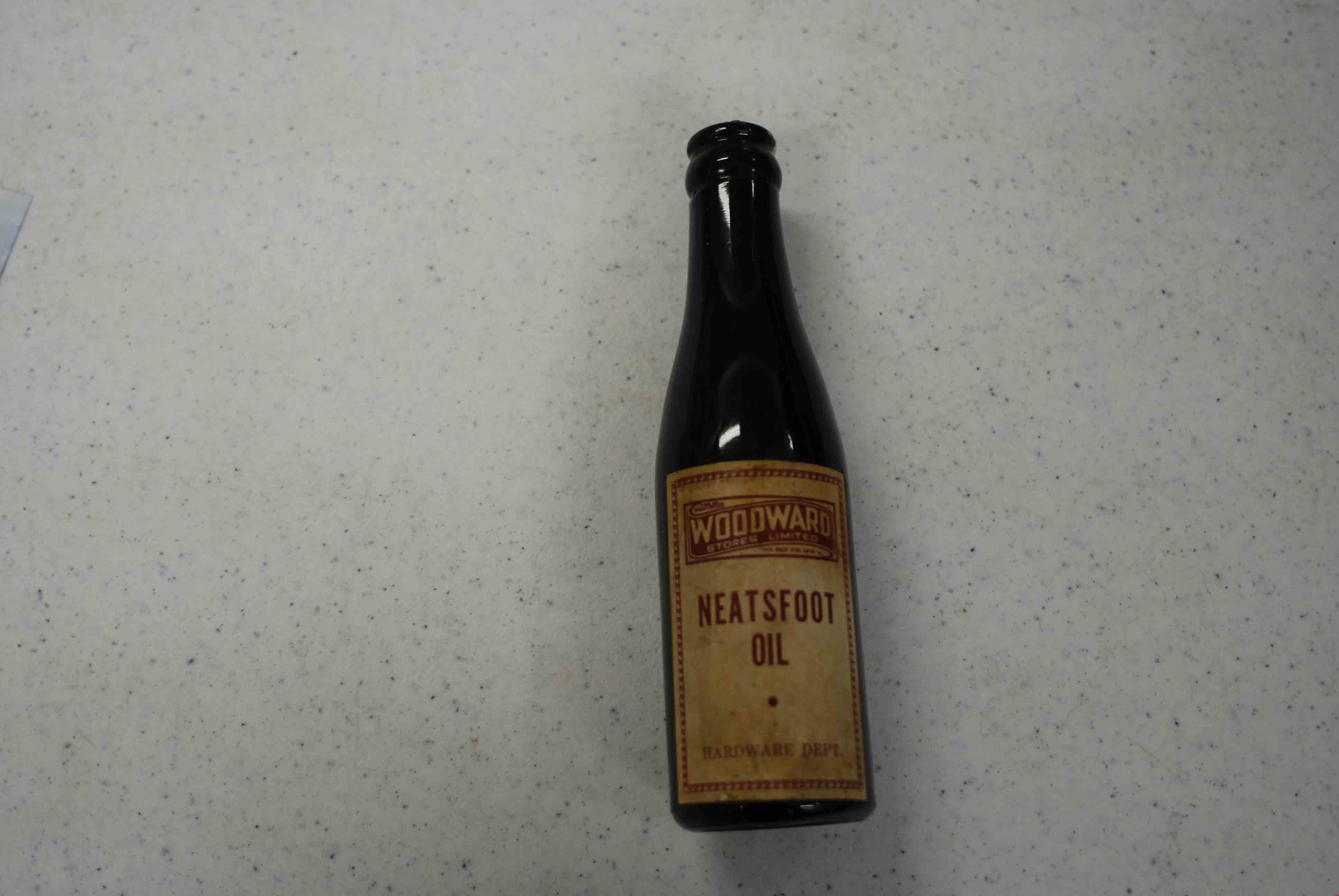
Neatsfoot oil
https://search.heritageburnaby.ca/link/museumartifact90304
- Repository
- Burnaby Village Museum
- Accession Code
- BV020.17.2
- Description
- A dark bootle conatining neatsfoot oil. A yellowed label on the bottle reads "Woodward Store Limited / Neatsfoot Oil / Hardware Dept." The bottle is corked and has some white paint on the opening.
- Object History
- This mask was used by Walter Westerman in the Sperling-Broadway area in Burnaby. Likely for home use. Walter went to school in Burnaby and grew up on Georgia Street. Walter, his wife Gwen and family moved to Duthie Street in Burnaby in 1969. He worked Lenkurt Electric on Lougheed at Bainbridge, as a machinist and was later the foreman of the sheet metal shop.
- Category
- 04.Tools & Equipment for Materials
- Classification
- Leather, Horn & Shellworking T&E
- Marks/Labels
- We Sell Everything / Woodward Stores Limited / The Best for Less / Neatsfoot Oil / Hardware Department
- Colour
- Brown
- Red
- Yellow
- Measurements
- 20 cm h x 5 cm in diameter
- Maker
- Woodward Stores Limited
- Country Made
- England
- Historic Neighbourhood
- Lochdale (Historic Neighbourhood)
- Planning Study Area
- Sperling-Broadway Area
Images

New Home on Phillips Avenue
https://search.heritageburnaby.ca/link/archivedescription78999
- Repository
- City of Burnaby Archives
- Date
- September 22, 1976
- Collection/Fonds
- Burnaby Public Library Contemporary Visual Archive Project
- Description Level
- Item
- Physical Description
- 1 photograph : b&w ; 11 x 16 cm mounted on cardboard
- Scope and Content
- Photograph shows a new, unoccupied home, on Phillips Avenue near the Lougheed Highway.
- Repository
- City of Burnaby Archives
- Date
- September 22, 1976
- Collection/Fonds
- Burnaby Public Library Contemporary Visual Archive Project
- Physical Description
- 1 photograph : b&w ; 11 x 16 cm mounted on cardboard
- Description Level
- Item
- Record No.
- 556-082
- Access Restriction
- No restrictions
- Reproduction Restriction
- Reproduce for fair dealing purposes only
- Accession Number
- 2013-13
- Scope and Content
- Photograph shows a new, unoccupied home, on Phillips Avenue near the Lougheed Highway.
- Subjects
- Construction
- Media Type
- Photograph
- Photographer
- McCarron, John
- Notes
- Scope note taken directly from BPL photograph description.
- 1 b&w copy negative : 10 x 12.5 cm accompanying
- Geographic Access
- Phillips Avenue
- Street Address
- 3120 Phillips Avenue
- Historic Neighbourhood
- Lochdale (Historic Neighbourhood)
- Planning Study Area
- Sperling-Broadway Area
Images

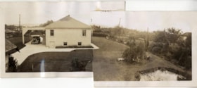
New house
https://search.heritageburnaby.ca/link/archivedescription97967
- Repository
- City of Burnaby Archives
- Date
- 1946
- Collection/Fonds
- Burnaby Historical Society fonds
- Description Level
- Item
- Physical Description
- 1 photograph : b&w ; 8 cm x 18 cm
- Scope and Content
- Photograph of the newly-built Easthope family home at 6671 Halifax Street. Photograph is comprised of two photographs glued together to create a panorama image of the exterior of the house and surrounding property.
- Repository
- City of Burnaby Archives
- Date
- 1946
- Collection/Fonds
- Burnaby Historical Society fonds
- Subseries
- Easthope family subseries
- Physical Description
- 1 photograph : b&w ; 8 cm x 18 cm
- Description Level
- Item
- Record No.
- 451-034
- Access Restriction
- No restrictions
- Reproduction Restriction
- No restrictions
- Accession Number
- BHS2003-06
- Scope and Content
- Photograph of the newly-built Easthope family home at 6671 Halifax Street. Photograph is comprised of two photographs glued together to create a panorama image of the exterior of the house and surrounding property.
- Subjects
- Persons - Students
- Media Type
- Photograph
- Notes
- Title based on contents of photograph
- Note in pencil on verso of photograph reads: "New house 1946. 6671 Halifax St. Burnaby, BC"
- Note in black ink on verso of photograph reads: "View from iddle of 1 acre lot towards south"
- Geographic Access
- Halifax Street
- Street Address
- 6671 Halifax Street
- Historic Neighbourhood
- Lochdale (Historic Neighbourhood)
- Planning Study Area
- Lochdale Area
Images

![Norman family, [1944] (date of original), copied 1991 thumbnail](/media/hpo/_Data/_Archives_Images/_Unrestricted/370/370-277.jpg?width=280)
Norman family
https://search.heritageburnaby.ca/link/archivedescription37689
- Repository
- City of Burnaby Archives
- Date
- [1944] (date of original), copied 1991
- Collection/Fonds
- Burnaby Historical Society fonds
- Description Level
- Item
- Physical Description
- 1 photograph : b&w ; 4.3 x 2.7 cm print on contact sheet 20.2 x 25.3 cm
- Scope and Content
- Photograph of Laurie and Elise Norman with their children at 6981 Curtis Street and Cliff Avenue.
- Repository
- City of Burnaby Archives
- Date
- [1944] (date of original), copied 1991
- Collection/Fonds
- Burnaby Historical Society fonds
- Subseries
- Burnaby Image Bank subseries
- Physical Description
- 1 photograph : b&w ; 4.3 x 2.7 cm print on contact sheet 20.2 x 25.3 cm
- Description Level
- Item
- Record No.
- 370-277
- Access Restriction
- No restrictions
- Reproduction Restriction
- No known restrictions
- Accession Number
- BHS1999-03
- Scope and Content
- Photograph of Laurie and Elise Norman with their children at 6981 Curtis Street and Cliff Avenue.
- Media Type
- Photograph
- Notes
- Title based on contents of photograph
- 1 b&w copy negative accompanying
- Geographic Access
- Curtis Street
- Street Address
- 6981 Curtis Street
- Historic Neighbourhood
- Lochdale (Historic Neighbourhood)
- Planning Study Area
- Lochdale Area
Images
![Norman family, [1944] (date of original), copied 1991 thumbnail](/media/hpo/_Data/_Archives_Images/_Unrestricted/370/370-277.jpg)
![Norman Song and Hans Johnson, [2002] thumbnail](/media/hpo/_Data/_Archives_Images/_Unrestricted/535/535-2515.jpg?width=280)
Norman Song and Hans Johnson
https://search.heritageburnaby.ca/link/archivedescription96960
- Repository
- City of Burnaby Archives
- Date
- [2002]
- Collection/Fonds
- Burnaby NewsLeader photograph collection
- Description Level
- Item
- Physical Description
- 1 photograph (tiff) : col.
- Scope and Content
- Photograph of Norman Song, of the St. Margaret's of Scotland Anglican Church, and Hans Johnson, a member of the council at Faith Lutheran Church, posing outside of St. Margaret's. They are part of a petition of churches in North Burnaby that oppose Chevron's application to increase its discharges.
- Repository
- City of Burnaby Archives
- Date
- [2002]
- Collection/Fonds
- Burnaby NewsLeader photograph collection
- Physical Description
- 1 photograph (tiff) : col.
- Description Level
- Item
- Record No.
- 535-2515
- Access Restriction
- No restrictions
- Reproduction Restriction
- No restrictions
- Accession Number
- 2018-12
- Scope and Content
- Photograph of Norman Song, of the St. Margaret's of Scotland Anglican Church, and Hans Johnson, a member of the council at Faith Lutheran Church, posing outside of St. Margaret's. They are part of a petition of churches in North Burnaby that oppose Chevron's application to increase its discharges.
- Media Type
- Photograph
- Photographer
- Bartel, Mario
- Notes
- Title based on caption
- Collected by editorial for use in a May 2002 issue of the Burnaby NewsLeader
- Caption from metadata: "Norman Song, of the St. Margaret's of Scotland Anglican Church, and Hans Johnson, a member of the council at Faith Lutheran Church, have been circulating a petition opposing Chevron's application to increase its discharges. Members from 13 churches in North Burnaby have signed the petition."
- Geographic Access
- Sperling Avenue
- Curtis Street
- Street Address
- 1030 Sperling Avenue
- Historic Neighbourhood
- Lochdale (Historic Neighbourhood)
- Planning Study Area
- Lochdale Area
Images
![Norman Song and Hans Johnson, [2002] thumbnail](/media/hpo/_Data/_Archives_Images/_Unrestricted/535/535-2515.jpg)
![North Burnaby, [1959] thumbnail](/media/hpo/_Data/_Archives_Images/_Unrestricted/001/106-001.jpg?width=280)
North Burnaby
https://search.heritageburnaby.ca/link/archivedescription34701
- Repository
- City of Burnaby Archives
- Date
- [1959]
- Collection/Fonds
- Burnaby Historical Society fonds
- Description Level
- Item
- Physical Description
- 1 photograph : b&w ; 16.6 x 20.5 cm
- Scope and Content
- Aerial photograph of North Burnaby and Burrard Inlet looking west.
- Repository
- City of Burnaby Archives
- Date
- [1959]
- Collection/Fonds
- Burnaby Historical Society fonds
- Subseries
- Photographs subseries
- Physical Description
- 1 photograph : b&w ; 16.6 x 20.5 cm
- Description Level
- Item
- Record No.
- 106-001
- Access Restriction
- No restrictions
- Reproduction Restriction
- Reproduce for fair dealing purposes only
- Accession Number
- BHS2007-04
- Scope and Content
- Aerial photograph of North Burnaby and Burrard Inlet looking west.
- Media Type
- Photograph
- Notes
- Title based on contents of photograph
- Historic Neighbourhood
- Vancouver Heights (Historic Neighbourhood)
- Capitol Hill (Historic Neighbourhood)
- Lochdale (Historic Neighbourhood)
- Planning Study Area
- Burnaby Heights Area
- Capitol Hill Area
- Westridge Area
- Willingdon Heights Area
- Brentwood Area
- Parkcrest-Aubrey Area
- Lochdale Area
Images
![North Burnaby, [1959] thumbnail](/media/hpo/_Data/_Archives_Images/_Unrestricted/001/106-001.jpg)

On Curtis Road, North Burnaby
https://search.heritageburnaby.ca/link/archivedescription38854
- Repository
- City of Burnaby Archives
- Date
- 1911
- Collection/Fonds
- Peers Family and Hill Family fonds
- Description Level
- Item
- Physical Description
- 1 photograph : b&w ; 6 x 10 cm on page 14 x 17.5 cm (pasted in album)
- Scope and Content
- Photograph of Claude Hill (right) and E.B. Wentenhall (left) standing on a bridge on Curtis Road in North Burnaby. Both men are holding walking sticks.
- Repository
- City of Burnaby Archives
- Date
- 1911
- Collection/Fonds
- Peers Family and Hill Family fonds
- Physical Description
- 1 photograph : b&w ; 6 x 10 cm on page 14 x 17.5 cm (pasted in album)
- Description Level
- Item
- Record No.
- 477-173
- Access Restriction
- No restrictions
- Reproduction Restriction
- No known restrictions
- Accession Number
- 2007-12
- Scope and Content
- Photograph of Claude Hill (right) and E.B. Wentenhall (left) standing on a bridge on Curtis Road in North Burnaby. Both men are holding walking sticks.
- Subjects
- Structures - Bridges
- Media Type
- Photograph
- Notes
- Title based on caption accompanying photograph
- Geographic Access
- Curtis Street
- Historic Neighbourhood
- Lochdale (Historic Neighbourhood)
- Planning Study Area
- Lochdale Area
Images


Ornamental fountain at 6657 East Broadway
https://search.heritageburnaby.ca/link/archivedescription78938
- Repository
- City of Burnaby Archives
- Date
- November 17,1976
- Collection/Fonds
- Burnaby Public Library Contemporary Visual Archive Project
- Description Level
- Item
- Physical Description
- 1 photograph : b&w ; 11 x 16 cm mounted on cardboard
- Scope and Content
- Photograph shows an ornamental fountain with various statues at 6657 East Broadway. The statues were supplied by Zanetti Arts.
- Repository
- City of Burnaby Archives
- Date
- November 17,1976
- Collection/Fonds
- Burnaby Public Library Contemporary Visual Archive Project
- Physical Description
- 1 photograph : b&w ; 11 x 16 cm mounted on cardboard
- Description Level
- Item
- Record No.
- 556-041
- Access Restriction
- No restrictions
- Reproduction Restriction
- Reproduce for fair dealing purposes only
- Accession Number
- 2013-13
- Scope and Content
- Photograph shows an ornamental fountain with various statues at 6657 East Broadway. The statues were supplied by Zanetti Arts.
- Names
- Zanetti Arts
- Media Type
- Photograph
- Photographer
- Born, A. J.
- Notes
- Scope note taken directly from BPL photograph description.
- 1 b&w copy negative : 10 x 12.5 cm accompanying
- Geographic Access
- Broadway
- Street Address
- 6657 Broadway
- Historic Neighbourhood
- Lochdale (Historic Neighbourhood)
- Planning Study Area
- Sperling-Broadway Area
Images

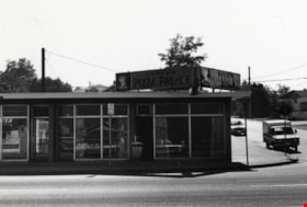
Paddy's Pizza Place
https://search.heritageburnaby.ca/link/archivedescription79328
- Repository
- City of Burnaby Archives
- Date
- September 16, 1976
- Collection/Fonds
- Burnaby Public Library Contemporary Visual Archive Project
- Description Level
- Item
- Physical Description
- 1 photograph : b&w ; 11 x 16 cm mounted on cardboard
- Scope and Content
- Photograph shows Paddy's Pizza Place, a restaurant located on Hastings Street at Grove Avenue, built in 1968.
- Repository
- City of Burnaby Archives
- Date
- September 16, 1976
- Collection/Fonds
- Burnaby Public Library Contemporary Visual Archive Project
- Physical Description
- 1 photograph : b&w ; 11 x 16 cm mounted on cardboard
- Description Level
- Item
- Record No.
- 556-244
- Access Restriction
- No restrictions
- Reproduction Restriction
- Reproduce for fair dealing purposes only
- Accession Number
- 2013-13
- Scope and Content
- Photograph shows Paddy's Pizza Place, a restaurant located on Hastings Street at Grove Avenue, built in 1968.
- Subjects
- Buildings - Commercial - Restaurants
- Names
- Paddy's Pizza Place
- Media Type
- Photograph
- Photographer
- Born, A. J.
- Notes
- Scope note taken directly from BPL photograph description.
- 1 b&w copy negative : 10 x 12.5 cm accompanying
- Geographic Access
- Hastings Street
- Grove Avenue
- Historic Neighbourhood
- Lochdale (Historic Neighbourhood)
- Planning Study Area
- Lochdale Area
Images


Pandemic Litter
https://search.heritageburnaby.ca/link/archivedescription95131
- Repository
- City of Burnaby Archives
- Date
- April 30, 2020
- Collection/Fonds
- Burnaby Photographic Society fonds
- Description Level
- Item
- Physical Description
- 1 photograph (tiff)
- Scope and Content
- Photograph of two blue rubber gloves discarded on the ground of the Kensington Square Shopping Centre parking lot in North Burnaby.
- Repository
- City of Burnaby Archives
- Date
- April 30, 2020
- Collection/Fonds
- Burnaby Photographic Society fonds
- Physical Description
- 1 photograph (tiff)
- Description Level
- Item
- Record No.
- 623-049
- Access Restriction
- No restrictions
- Reproduction Restriction
- No restrictions
- Accession Number
- 2020-10
- Scope and Content
- Photograph of two blue rubber gloves discarded on the ground of the Kensington Square Shopping Centre parking lot in North Burnaby.
- Media Type
- Photograph
- Photographer
- Lapierre, Soleil
- Notes
- Transcribed title
- Geographic Access
- Hastings Street
- Street Address
- 6500 Hastings Street
- Historic Neighbourhood
- Lochdale (Historic Neighbourhood)
- Planning Study Area
- Lochdale Area
Images

![Pappagallo Cafe relocation, [2003] thumbnail](/media/hpo/_Data/_Archives_Images/_Unrestricted/535/535-1820.jpg?width=280)
Pappagallo Cafe relocation
https://search.heritageburnaby.ca/link/archivedescription96117
- Repository
- City of Burnaby Archives
- Date
- [2003]
- Collection/Fonds
- Burnaby NewsLeader photograph collection
- Description Level
- Item
- Physical Description
- 1 photograph (tiff) : col.
- Scope and Content
- Photograph of Rene Longo, owner of the Pappagallo Cafe, posing behind the bar the coffee shop in Kensington Plaza.
- Repository
- City of Burnaby Archives
- Date
- [2003]
- Collection/Fonds
- Burnaby NewsLeader photograph collection
- Physical Description
- 1 photograph (tiff) : col.
- Description Level
- Item
- Record No.
- 535-1820
- Access Restriction
- No restrictions
- Reproduction Restriction
- No restrictions
- Accession Number
- 2018-12
- Scope and Content
- Photograph of Rene Longo, owner of the Pappagallo Cafe, posing behind the bar the coffee shop in Kensington Plaza.
- Subjects
- Buildings - Commercial - Restaurants
- Media Type
- Photograph
- Photographer
- Bartel, Mario
- Notes
- Title based on caption
- Collected by editorial for use in a January 2003 issue of the Burnaby NewsLeader
- Caption from metadata: "Rene Longo says he's being forced to moved his family-owned coffee shop, Pappagallo Cafe, from the Kensington Plaza, where it's been for ten years, to make way for a Starbucks. He's found a new location, about half a block away, on Hastings St."
- Geographic Access
- Hastings Street
- Historic Neighbourhood
- Lochdale (Historic Neighbourhood)
- Planning Study Area
- Lochdale Area
Images
![Pappagallo Cafe relocation, [2003] thumbnail](/media/hpo/_Data/_Archives_Images/_Unrestricted/535/535-1820.jpg)

Parkcrest Bible Chapel
https://search.heritageburnaby.ca/link/archivedescription79045
- Repository
- City of Burnaby Archives
- Date
- September 7, 1976
- Collection/Fonds
- Burnaby Public Library Contemporary Visual Archive Project
- Description Level
- Item
- Physical Description
- 1 photograph : b&w ; 11 x 16 cm mounted on cardboard
- Scope and Content
- Photograph shows the Parkcrest Bible Chapel at 6641 Halifax Street. It was built in 1962.
- Repository
- City of Burnaby Archives
- Date
- September 7, 1976
- Collection/Fonds
- Burnaby Public Library Contemporary Visual Archive Project
- Physical Description
- 1 photograph : b&w ; 11 x 16 cm mounted on cardboard
- Description Level
- Item
- Record No.
- 556-112
- Access Restriction
- No restrictions
- Reproduction Restriction
- Reproduce for fair dealing purposes only
- Accession Number
- 2013-13
- Scope and Content
- Photograph shows the Parkcrest Bible Chapel at 6641 Halifax Street. It was built in 1962.
- Subjects
- Buildings - Religious - Churches
- Names
- Parkcrest Bible Chapel
- Media Type
- Photograph
- Photographer
- Born, A. J.
- Notes
- Scope note taken directly from BPL photograph description.
- 1 b&w copy negative : 10 x 12.5 cm accompanying
- Geographic Access
- Halifax Street
- Street Address
- 6641 Halifaxt Street
- Historic Neighbourhood
- Lochdale (Historic Neighbourhood)
- Planning Study Area
- Lochdale Area
Images

![Pengelly's logging shack, [1909] thumbnail](/media/hpo/_Data/_Archives_Images/_Unrestricted/205/222-005.jpg?width=280)
Pengelly's logging shack
https://search.heritageburnaby.ca/link/archivedescription36082
- Repository
- City of Burnaby Archives
- Date
- [1909]
- Collection/Fonds
- Burnaby Historical Society fonds
- Description Level
- Item
- Physical Description
- 1 photograph : b&w ; 9 x 11.5 cm
- Scope and Content
- Photograph of Pengelly's logging shack, believed to be at Union Street and Duthie Avenue. One lumberjack is standing just outside the shack with an axe in his hand, while another is wiping his face with a cloth and a third is standing with one foot bracing a felled log with a saw in his hand.
- Repository
- City of Burnaby Archives
- Date
- [1909]
- Collection/Fonds
- Burnaby Historical Society fonds
- Subseries
- Columbian Newspaper subseries
- Physical Description
- 1 photograph : b&w ; 9 x 11.5 cm
- Description Level
- Item
- Record No.
- 222-005
- Access Restriction
- No restrictions
- Reproduction Restriction
- No known restrictions
- Accession Number
- BHS1989-19
- Scope and Content
- Photograph of Pengelly's logging shack, believed to be at Union Street and Duthie Avenue. One lumberjack is standing just outside the shack with an axe in his hand, while another is wiping his face with a cloth and a third is standing with one foot bracing a felled log with a saw in his hand.
- Media Type
- Photograph
- Notes
- Title based on contents of photograph
- 2 b&w copy negatives accompanying
- Geographic Access
- Duthie Avenue
- Union Street
- Historic Neighbourhood
- Lochdale (Historic Neighbourhood)
- Planning Study Area
- Lochdale Area
Images
![Pengelly's logging shack, [1909] thumbnail](/media/hpo/_Data/_Archives_Images/_Unrestricted/205/222-005.jpg)

Playground at Sperling Elementary School
https://search.heritageburnaby.ca/link/museumdescription14738
- Repository
- Burnaby Village Museum
- Date
- 9 Apr. 2020
- Collection/Fonds
- Burnaby Village Museum COVID-19 collection
- Description Level
- Item
- Physical Description
- 1 photograph (jpg) : col. ; 72 dpi.
- Scope and Content
- Photograph of the playground outside of Sperling Elementary School in Burnaby. The playground equipment is surrounded by yellow caution tape to prevent anyone from using it. The playground was closed down along with other parks by the City of Burnaby in the spring of 2020 due to the COVID-19 pandem…
- Repository
- Burnaby Village Museum
- Collection/Fonds
- Burnaby Village Museum COVID-19 collection
- Description Level
- Item
- Physical Description
- 1 photograph (jpg) : col. ; 72 dpi.
- Scope and Content
- Photograph of the playground outside of Sperling Elementary School in Burnaby. The playground equipment is surrounded by yellow caution tape to prevent anyone from using it. The playground was closed down along with other parks by the City of Burnaby in the spring of 2020 due to the COVID-19 pandemic and public health orders.
- History
- Tristan Johnson took photos around Burnaby because as a parent of two elementary school aged children during the COVID-19 pandemic, one of the most notable things about COVID-19 during Spring 2020 was the closure of playgrounds and the playgrounds being taped up.
- Names
- Sperling Avenue School
- Accession Code
- BV020.21.3
- Access Restriction
- No restrictions
- Reproduction Restriction
- No known restrictions
- Date
- 9 Apr. 2020
- Media Type
- Photograph
- Historic Neighbourhood
- Lochdale (Historic Neighbourhood)
- Planning Study Area
- Sperling-Broadway Area
- Photographer
- Johnson, Tristan
- Notes
- Title based on contents of photograph
Images
