Narrow Results By
Person / Organization
- A & Aero Trading Salvage 2
- Bossort, Kathy 6
- Burnaby Automotive 1
- Burnaby Mountain Autobody 1
- Burnaby Mountain Conservation Area 1
- Burnaby Mountain Golf Course 11
- Burnaby Mountain Parkway 1
- Burnaby Public Library Board 1
- Culos, Ray J. 1
- Dahling, Bob 1
- Dedemus (Lloyd) Electric Ltd. 1
- Easthope, Dorothy May Parkes 1
Interview with Maureen Olofson by Kathy Bossort October 14, 2015 - Track 3
https://search.heritageburnaby.ca/link/oralhistory571
- Repository
- City of Burnaby Archives
- Date Range
- 1942-1980
- Length
- 0:06:55
- Summary
- This portion of the interview is about Maureen Olofson’s description of the food sources on the farm including the garden, food animals, berry picking and bears. She also describes what her parents did after giving up the farm, opening sporting good stores on Hastings Street and then in North Vanco…
- Repository
- City of Burnaby Archives
- Summary
- This portion of the interview is about Maureen Olofson’s description of the food sources on the farm including the garden, food animals, berry picking and bears. She also describes what her parents did after giving up the farm, opening sporting good stores on Hastings Street and then in North Vancouver.
- Date Range
- 1942-1980
- Length
- 0:06:55
- Names
- Olofson, Axel
- GAK Fur Farm
- Geographic Access
- Burnaby Mountain Conservation Area
- Historic Neighbourhood
- Lochdale (Historic Neighbourhood)
- Planning Study Area
- Westridge Area
- Lochdale Area
- Interviewer
- Bossort, Kathy
- Interview Date
- October 14, 2015
- Scope and Content
- Recording is of an interview with Maureen Olofson conducted by Kathy Bossort. Maureen Olofson was one of 23 participants interviewed as part of the Community Heritage Commission’s Burnaby Mountain Oral History Project. The interview is mainly about Maureen Olofson’s memories of growing up on her parent’s Burnaby Mountain mink ranch between 1942 and 1950 and about the operation of the farm. She also talks about her parents’ history, her teaching career, and her thoughts about the beauty and value of Burnaby Mountain’s natural area.
- Biographical Notes
- Maureen Olofson was born 1938 in Glote, Harjedalen, Sweden, to Axel (1906-1998) and Kerstin Margareta (1906-1980). Axel and Kerstin Olofson, who had separately immigrated to Canada in 1928 and 1913 respectively, married in Canada and then returned to Sweden where Maureen was born. They moved to Burnaby in 1942 with their daughters Maureen and Anita Lea, and bought land and a mink ranch on Burnaby Mountain with their partners Gus Skofteby and Karin Ericksson (Kerstin’s sister). The GAK Fur Farm, located in the old Hastings Grove subdivision on 4th Avenue near Curtis Street, was one of the largest mink ranches in BC, an award winning operation with over 1200 mink animals. In 1950 the partners sold the land and the Olofson family moved to rented homes on Sperling Avenue. In 1952 Axel sold the last of his minks and opened a sporting goods store on Hastings Street. In 1954 the family moved to North Vancouver where Axel Olofson reestablished his sports business. Maureen attended Sperling Avenue School from Gr. 1 to Gr. 8 and Burnaby North High School to Gr. 11, completing school in North Vancouver, before going to UBC where she trained as a teacher. She returned to Burnaby in 1977 to teach, retiring in 1997. She is a volunteer with the Swedish Canadian Rest Home Association and the Dania Homes Society. Maureen continues to enjoy activities on Burnaby Mountain and works toward preserving the natural beauty of the mountain.
- Total Tracks
- 8
- Total Length
- 1:19:04
- Interviewee Name
- Olofson, B. Maureen
- Interview Location
- Maureen Olofson's home in Burnaby
- Interviewer Bio
- Kathy Bossort is a retired archivist living in Ladner, BC. She worked at the Delta Museum and Archives after graduating from SLAIS (UBC) in 2001 with Masters degrees in library science and archival studies. Kathy grew up in Calgary, Alberta, and, prior to this career change, she lived in the West Kootenays, earning her living as a cook for BC tourist lodges and work camps. She continues to be interested in oral histories as a way to fill the gaps in the written record and bring richer meaning to history.
- Collection/Fonds
- Community Heritage Commission Special Projects fonds
- Media Type
- Sound Recording
Audio Tracks
Track three of interview with Maureen Olofson
Track three of interview with Maureen Olofson
https://search.heritageburnaby.ca/media/hpo/_Data/_Archives_Oral_Histories/_Unrestricted/MSS196-004/MSS196-004_Track_3.mp3Interview with Reidun Seim by Kathy Bossort January 13, 2016 - Track 3
https://search.heritageburnaby.ca/link/oralhistory652
- Repository
- City of Burnaby Archives
- Date Range
- 1934-1990
- Length
- 0:15:30
- Summary
- This portion of the interview is about Reidun Seim talking about her father’s chicken farm. She describes the farm buildings, other animals on the farm, and how her father operated the chicken farm, especially his approach to keeping the chickens disease free. She also talks about cutting down the …
- Repository
- City of Burnaby Archives
- Summary
- This portion of the interview is about Reidun Seim talking about her father’s chicken farm. She describes the farm buildings, other animals on the farm, and how her father operated the chicken farm, especially his approach to keeping the chickens disease free. She also talks about cutting down the alder at the back of the property for the chicken run, and building rock walls and a driveway with rocks taken off the property. She also describes how the property was subdivided in the 1980s.
- Date Range
- 1934-1990
- Length
- 0:15:30
- Subjects
- Occupations - Farmers
- Animals - Poultry
- Geographic Access
- Curtis Street
- Historic Neighbourhood
- Lochdale (Historic Neighbourhood)
- Planning Study Area
- Lochdale Area
- Interviewer
- Bossort, Kathy
- Interview Date
- January 13, 2016
- Scope and Content
- Recording is of an interview with Reidun Seim conducted by Kathy Bossort. Reidun Seim was one of 23 participants interviewed as part of the Community Heritage Commission’s Burnaby Mountain Oral History Project. The interview is mainly about Reidun Seim’s memories about her parent’s farm on Curtis Street, events in her childhood, and the people who lived in or visited her neighborhood. She takes us on a tour of her neighborhood in the 1940s, telling us stories about families who lived on Curtis Street on and east of 7300 block, including people who lived on Burnaby Mountain in the old Hastings Grove subdivision above the end of municipal water service at Philips Avenue. She describes changes to Curtis Street, particularly after it provided access to Simon Fraser University in 1965. She also talks about her teaching career, and about how she values the green space and conservation area on Burnaby Mountain.
- Biographical Notes
- Reidun Seim was born in 1931 in Vancouver B.C. to Sjur and Martine Seim. Sjur and Martine Seim emigrated to Canada from Norway in 1930, and after settling in Vancouver, moved to an acre of land and a new home at the base of Burnaby Mountain in 1932. Sjur attended UBC to learn about poultry farming and began his own chicken and egg business in 1935. The farm animals and large garden also contributed to the family’s livelihood and self-sufficiency. The Curtis Street neighborhood was a lively place and extended well up Curtis Street on the west slope of Burnaby Mountain, where Reidun would babysit for families. Reidun attended Sperling Avenue Elementary School (Gr. 1-8), Burnaby North High School, and Vancouver Normal School for teacher training in 1950-1951. She began teaching primary grades in Port Coquitlam at James Park School. Most of her career was spent in North Delta, teaching at Kennedy and Annieville schools from 1954-1958, appointed Primary Consultant (1958-1960) and Primary Supervisor (1960-1985), before retiring in 1986. Reidun lived at home with her parents on Curtis Street, commuting to Delta, and continues to live in the original farmhouse.
- Total Tracks
- 14
- Total Length
- 2:35:58
- Interviewee Name
- Seim, Reidun
- Interview Location
- Burnaby City Hall in the Law Library
- Interviewer Bio
- Kathy Bossort is a retired archivist living in Ladner, BC. She worked at the Delta Museum and Archives after graduating from SLAIS (UBC) in 2001 with Masters degrees in library science and archival studies. Kathy grew up in Calgary, Alberta, and, prior to this career change, she lived in the West Kootenays, earning her living as a cook for BC tourist lodges and work camps. She continues to be interested in oral histories as a way to fill the gaps in the written record and bring richer meaning to history.
- Collection/Fonds
- Community Heritage Commission Special Projects fonds
- Media Type
- Sound Recording
Audio Tracks
Track three of interview with Reidun Seim
Track three of interview with Reidun Seim
https://search.heritageburnaby.ca/media/hpo/_Data/_Archives_Oral_Histories/_Unrestricted/MSS196-017/MSS196-017_Track_3.mp3Interview with Reidun Seim by Kathy Bossort January 13, 2016 - Track 12
https://search.heritageburnaby.ca/link/oralhistory661
- Repository
- City of Burnaby Archives
- Date Range
- 1963-2015
- Length
- 0:13:53
- Summary
- This portion of the interview is about Reidun Seim talking about the building of Simon Fraser University and how it impacted the neighborhood on Curtis Street, including increase in property values, traffic volume and speeding, street congestion due to parking, and students renting local homes. She…
- Repository
- City of Burnaby Archives
- Summary
- This portion of the interview is about Reidun Seim talking about the building of Simon Fraser University and how it impacted the neighborhood on Curtis Street, including increase in property values, traffic volume and speeding, street congestion due to parking, and students renting local homes. She talks about how the building of the Burnaby Mountain Parkway helped alleviate the traffic problem. She also talks about how SFU has benefitted Burnaby.
- Date Range
- 1963-2015
- Length
- 0:13:53
- Geographic Access
- Burnaby Mountain Conservation Area
- Curtis Street
- Historic Neighbourhood
- Lochdale (Historic Neighbourhood)
- Planning Study Area
- Lochdale Area
- Westridge Area
- Interviewer
- Bossort, Kathy
- Interview Date
- January 13, 2016
- Scope and Content
- Recording is of an interview with Reidun Seim conducted by Kathy Bossort. Reidun Seim was one of 23 participants interviewed as part of the Community Heritage Commission’s Burnaby Mountain Oral History Project. The interview is mainly about Reidun Seim’s memories about her parent’s farm on Curtis Street, events in her childhood, and the people who lived in or visited her neighborhood. She takes us on a tour of her neighborhood in the 1940s, telling us stories about families who lived on Curtis Street on and east of 7300 block, including people who lived on Burnaby Mountain in the old Hastings Grove subdivision above the end of municipal water service at Philips Avenue. She describes changes to Curtis Street, particularly after it provided access to Simon Fraser University in 1965. She also talks about her teaching career, and about how she values the green space and conservation area on Burnaby Mountain.
- Biographical Notes
- Reidun Seim was born in 1931 in Vancouver B.C. to Sjur and Martine Seim. Sjur and Martine Seim emigrated to Canada from Norway in 1930, and after settling in Vancouver, moved to an acre of land and a new home at the base of Burnaby Mountain in 1932. Sjur attended UBC to learn about poultry farming and began his own chicken and egg business in 1935. The farm animals and large garden also contributed to the family’s livelihood and self-sufficiency. The Curtis Street neighborhood was a lively place and extended well up Curtis Street on the west slope of Burnaby Mountain, where Reidun would babysit for families. Reidun attended Sperling Avenue Elementary School (Gr. 1-8), Burnaby North High School, and Vancouver Normal School for teacher training in 1950-1951. She began teaching primary grades in Port Coquitlam at James Park School. Most of her career was spent in North Delta, teaching at Kennedy and Annieville schools from 1954-1958, appointed Primary Consultant (1958-1960) and Primary Supervisor (1960-1985), before retiring in 1986. Reidun lived at home with her parents on Curtis Street, commuting to Delta, and continues to live in the original farmhouse.
- Total Tracks
- 14
- Total Length
- 2:35:58
- Interviewee Name
- Seim, Reidun
- Interview Location
- Burnaby City Hall in the Law Library
- Interviewer Bio
- Kathy Bossort is a retired archivist living in Ladner, BC. She worked at the Delta Museum and Archives after graduating from SLAIS (UBC) in 2001 with Masters degrees in library science and archival studies. Kathy grew up in Calgary, Alberta, and, prior to this career change, she lived in the West Kootenays, earning her living as a cook for BC tourist lodges and work camps. She continues to be interested in oral histories as a way to fill the gaps in the written record and bring richer meaning to history.
- Collection/Fonds
- Community Heritage Commission Special Projects fonds
- Media Type
- Sound Recording
Audio Tracks
Track twelve of interview with Reidun Seim
Track twelve of interview with Reidun Seim
https://search.heritageburnaby.ca/media/hpo/_Data/_Archives_Oral_Histories/_Unrestricted/MSS196-017/MSS196-017_Track_12.mp3Interview with Reidun Seim by Kathy Bossort January 13, 2016 - Track 13
https://search.heritageburnaby.ca/link/oralhistory662
- Repository
- City of Burnaby Archives
- Date Range
- 1965-2015
- Length
- 0:16:00
- Summary
- This portion of the interview is about Reidun Seim talking about what the Burnaby Mountain Conservation Area means to her, and how green space benefits people, especially giving them the freedom and safety she remembers from her childhood. She talks about her concern about the construction of Unive…
- Repository
- City of Burnaby Archives
- Summary
- This portion of the interview is about Reidun Seim talking about what the Burnaby Mountain Conservation Area means to her, and how green space benefits people, especially giving them the freedom and safety she remembers from her childhood. She talks about her concern about the construction of UniverCity and its impact on erosion and water drainage from the mountain. She tells a story about flooding from overflowing ditches on Curtis Street in the 1970s.
- Date Range
- 1965-2015
- Length
- 0:16:00
- Geographic Access
- Burnaby Mountain Conservation Area
- Historic Neighbourhood
- Lochdale (Historic Neighbourhood)
- Planning Study Area
- Lochdale Area
- Westridge Area
- Interviewer
- Bossort, Kathy
- Interview Date
- January 13, 2016
- Scope and Content
- Recording is of an interview with Reidun Seim conducted by Kathy Bossort. Reidun Seim was one of 23 participants interviewed as part of the Community Heritage Commission’s Burnaby Mountain Oral History Project. The interview is mainly about Reidun Seim’s memories about her parent’s farm on Curtis Street, events in her childhood, and the people who lived in or visited her neighborhood. She takes us on a tour of her neighborhood in the 1940s, telling us stories about families who lived on Curtis Street on and east of 7300 block, including people who lived on Burnaby Mountain in the old Hastings Grove subdivision above the end of municipal water service at Philips Avenue. She describes changes to Curtis Street, particularly after it provided access to Simon Fraser University in 1965. She also talks about her teaching career, and about how she values the green space and conservation area on Burnaby Mountain.
- Biographical Notes
- Reidun Seim was born in 1931 in Vancouver B.C. to Sjur and Martine Seim. Sjur and Martine Seim emigrated to Canada from Norway in 1930, and after settling in Vancouver, moved to an acre of land and a new home at the base of Burnaby Mountain in 1932. Sjur attended UBC to learn about poultry farming and began his own chicken and egg business in 1935. The farm animals and large garden also contributed to the family’s livelihood and self-sufficiency. The Curtis Street neighborhood was a lively place and extended well up Curtis Street on the west slope of Burnaby Mountain, where Reidun would babysit for families. Reidun attended Sperling Avenue Elementary School (Gr. 1-8), Burnaby North High School, and Vancouver Normal School for teacher training in 1950-1951. She began teaching primary grades in Port Coquitlam at James Park School. Most of her career was spent in North Delta, teaching at Kennedy and Annieville schools from 1954-1958, appointed Primary Consultant (1958-1960) and Primary Supervisor (1960-1985), before retiring in 1986. Reidun lived at home with her parents on Curtis Street, commuting to Delta, and continues to live in the original farmhouse.
- Total Tracks
- 14
- Total Length
- 2:35:58
- Interviewee Name
- Seim, Reidun
- Interview Location
- Burnaby City Hall in the Law Library
- Interviewer Bio
- Kathy Bossort is a retired archivist living in Ladner, BC. She worked at the Delta Museum and Archives after graduating from SLAIS (UBC) in 2001 with Masters degrees in library science and archival studies. Kathy grew up in Calgary, Alberta, and, prior to this career change, she lived in the West Kootenays, earning her living as a cook for BC tourist lodges and work camps. She continues to be interested in oral histories as a way to fill the gaps in the written record and bring richer meaning to history.
- Collection/Fonds
- Community Heritage Commission Special Projects fonds
- Media Type
- Sound Recording
Audio Tracks
Track thirteen of interview with Reidun Seim
Track thirteen of interview with Reidun Seim
https://search.heritageburnaby.ca/media/hpo/_Data/_Archives_Oral_Histories/_Unrestricted/MSS196-017/MSS196-017_Track_13.mp3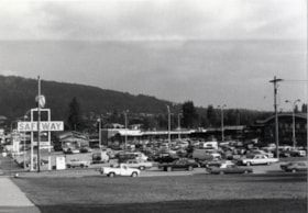
Kensington Plaza
https://search.heritageburnaby.ca/link/archivedescription79133
- Repository
- City of Burnaby Archives
- Date
- October 16, 1976
- Collection/Fonds
- Burnaby Public Library Contemporary Visual Archive Project
- Description Level
- Item
- Physical Description
- 1 photograph : b&w ; 11 x 16 cm mounted on cardboard
- Scope and Content
- Photograph shows the parking lot at the Kensington Plaza on Hastings Street at the corner of Kensington Avenue.
- Repository
- City of Burnaby Archives
- Date
- October 16, 1976
- Collection/Fonds
- Burnaby Public Library Contemporary Visual Archive Project
- Physical Description
- 1 photograph : b&w ; 11 x 16 cm mounted on cardboard
- Description Level
- Item
- Record No.
- 556-175
- Access Restriction
- No restrictions
- Reproduction Restriction
- Reproduce for fair dealing purposes only
- Accession Number
- 2013-13
- Scope and Content
- Photograph shows the parking lot at the Kensington Plaza on Hastings Street at the corner of Kensington Avenue.
- Subjects
- Buildings - Commercial - Stores
- Names
- Safeway
- Media Type
- Photograph
- Notes
- Scope note taken directly from BPL photograph description.
- 1 b&w copy negative : 10 x 12.5 cm accompanying
- Photographers identified by surnames only: Carr and Vardeman
- Geographic Access
- Hastings Street
- Street Address
- 6500 Hastings Street
- Historic Neighbourhood
- Lochdale (Historic Neighbourhood)
- Planning Study Area
- Lochdale Area
Images


Lochdale Community Hall
https://search.heritageburnaby.ca/link/archivedescription93672
- Repository
- City of Burnaby Archives
- Date
- January 18, 1978
- Collection/Fonds
- Burnaby Public Library Contemporary Visual Archive Project
- Description Level
- Item
- Physical Description
- 1 photograph : b&w ; 12.5 x 17.5 cm
- Scope and Content
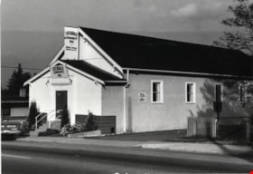
- Photograph of the front exterior of Lochdale Community Hall, located near Sperling and Hastings Street and built in 1925. Cars are parked in front of and beside the hall. The photograph is taken from across the street, facing east.
- Repository
- City of Burnaby Archives
- Date
- January 18, 1978
- Collection/Fonds
- Burnaby Public Library Contemporary Visual Archive Project
- Physical Description
- 1 photograph : b&w ; 12.5 x 17.5 cm
- Description Level
- Item
- Record No.
- 556-629
- Access Restriction
- No restrictions
- Reproduction Restriction
- Reproduce for fair dealing purposes only
- Accession Number
- 2017-57
- Scope and Content
- Photograph of the front exterior of Lochdale Community Hall, located near Sperling and Hastings Street and built in 1925. Cars are parked in front of and beside the hall. The photograph is taken from across the street, facing east.
- Names
- Lochdale Community Hall
- Media Type
- Photograph
- Photographer
- Surridge, Jack
- Notes
- Title taken from project information form
- Accompanied by a project information form and 1 photograph (b&w negative ; 9.5 x 12.5 cm)
- BPL no. 78
- Geographic Access
- Hastings Street
- Sperling Avenue
- Street Address
- 490 Sperling Avenue
- Historic Neighbourhood
- Lochdale (Historic Neighbourhood)
- Planning Study Area
- Lochdale Area
Images

Lochdale Community Hall
https://search.heritageburnaby.ca/link/archivedescription79730
- Repository
- City of Burnaby Archives
- Date
- October 16, 1976
- Collection/Fonds
- Burnaby Public Library Contemporary Visual Archive Project
- Description Level
- Item
- Physical Description
- 1 photograph : b&w ; 11 x 16 cm mounted on cardboard
- Scope and Content
- Photograph shows the Lochdale Community Hall on Sperling Avenue near Hastings Street.
- Repository
- City of Burnaby Archives
- Date
- October 16, 1976
- Collection/Fonds
- Burnaby Public Library Contemporary Visual Archive Project
- Physical Description
- 1 photograph : b&w ; 11 x 16 cm mounted on cardboard
- Description Level
- Item
- Record No.
- 556-405
- Access Restriction
- No restrictions
- Reproduction Restriction
- Reproduce for fair dealing purposes only
- Accession Number
- 2013-13
- Scope and Content
- Photograph shows the Lochdale Community Hall on Sperling Avenue near Hastings Street.
- Names
- Lochdale Community Hall
- Media Type
- Photograph
- Notes
- Scope note taken directly from BPL photograph description.
- 1 b&w copy negative : 10 x 12.5 cm accompanying
- Photographers identified by surnames only: Carr and Vardeman
- Geographic Access
- Sperling Avenue
- Street Address
- 490 Sperling Avenue
- Historic Neighbourhood
- Lochdale (Historic Neighbourhood)
- Planning Study Area
- Lochdale Area
Images


Lochdale Neighbourhood
https://search.heritageburnaby.ca/link/landmark790
- Repository
- Burnaby Heritage Planning
- Associated Dates
- 1955-2008
- Heritage Value
- Despite the rapid growth witnessed in Burnaby in the post-war years, the Lochdale Neighbourhood was characterised as a close-knit primarily residential community. Although a commercial zone developed along Sperling and Hastings, single-family, duplex and multi-family homes were the primary buildings in the area. Basement suites and student accommodation also flourished in this neighbourhood after the creation of Simon Fraser University on Burnaby Mountain.
- Historic Neighbourhood
- Lochdale (Historic Neighbourhood)
- Planning Study Area
- Lochdale Area
Images


New Home on Phillips Avenue
https://search.heritageburnaby.ca/link/archivedescription78999
- Repository
- City of Burnaby Archives
- Date
- September 22, 1976
- Collection/Fonds
- Burnaby Public Library Contemporary Visual Archive Project
- Description Level
- Item
- Physical Description
- 1 photograph : b&w ; 11 x 16 cm mounted on cardboard
- Scope and Content
- Photograph shows a new, unoccupied home, on Phillips Avenue near the Lougheed Highway.
- Repository
- City of Burnaby Archives
- Date
- September 22, 1976
- Collection/Fonds
- Burnaby Public Library Contemporary Visual Archive Project
- Physical Description
- 1 photograph : b&w ; 11 x 16 cm mounted on cardboard
- Description Level
- Item
- Record No.
- 556-082
- Access Restriction
- No restrictions
- Reproduction Restriction
- Reproduce for fair dealing purposes only
- Accession Number
- 2013-13
- Scope and Content
- Photograph shows a new, unoccupied home, on Phillips Avenue near the Lougheed Highway.
- Subjects
- Construction
- Media Type
- Photograph
- Photographer
- McCarron, John
- Notes
- Scope note taken directly from BPL photograph description.
- 1 b&w copy negative : 10 x 12.5 cm accompanying
- Geographic Access
- Phillips Avenue
- Street Address
- 3120 Phillips Avenue
- Historic Neighbourhood
- Lochdale (Historic Neighbourhood)
- Planning Study Area
- Sperling-Broadway Area
Images


Ornamental fountain at 6657 East Broadway
https://search.heritageburnaby.ca/link/archivedescription78938
- Repository
- City of Burnaby Archives
- Date
- November 17,1976
- Collection/Fonds
- Burnaby Public Library Contemporary Visual Archive Project
- Description Level
- Item
- Physical Description
- 1 photograph : b&w ; 11 x 16 cm mounted on cardboard
- Scope and Content
- Photograph shows an ornamental fountain with various statues at 6657 East Broadway. The statues were supplied by Zanetti Arts.
- Repository
- City of Burnaby Archives
- Date
- November 17,1976
- Collection/Fonds
- Burnaby Public Library Contemporary Visual Archive Project
- Physical Description
- 1 photograph : b&w ; 11 x 16 cm mounted on cardboard
- Description Level
- Item
- Record No.
- 556-041
- Access Restriction
- No restrictions
- Reproduction Restriction
- Reproduce for fair dealing purposes only
- Accession Number
- 2013-13
- Scope and Content
- Photograph shows an ornamental fountain with various statues at 6657 East Broadway. The statues were supplied by Zanetti Arts.
- Names
- Zanetti Arts
- Media Type
- Photograph
- Photographer
- Born, A. J.
- Notes
- Scope note taken directly from BPL photograph description.
- 1 b&w copy negative : 10 x 12.5 cm accompanying
- Geographic Access
- Broadway
- Street Address
- 6657 Broadway
- Historic Neighbourhood
- Lochdale (Historic Neighbourhood)
- Planning Study Area
- Sperling-Broadway Area
Images

Paddy's Pizza Place
https://search.heritageburnaby.ca/link/archivedescription79328
- Repository
- City of Burnaby Archives
- Date
- September 16, 1976
- Collection/Fonds
- Burnaby Public Library Contemporary Visual Archive Project
- Description Level
- Item
- Physical Description
- 1 photograph : b&w ; 11 x 16 cm mounted on cardboard
- Scope and Content
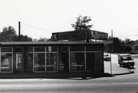
- Photograph shows Paddy's Pizza Place, a restaurant located on Hastings Street at Grove Avenue, built in 1968.
- Repository
- City of Burnaby Archives
- Date
- September 16, 1976
- Collection/Fonds
- Burnaby Public Library Contemporary Visual Archive Project
- Physical Description
- 1 photograph : b&w ; 11 x 16 cm mounted on cardboard
- Description Level
- Item
- Record No.
- 556-244
- Access Restriction
- No restrictions
- Reproduction Restriction
- Reproduce for fair dealing purposes only
- Accession Number
- 2013-13
- Scope and Content
- Photograph shows Paddy's Pizza Place, a restaurant located on Hastings Street at Grove Avenue, built in 1968.
- Subjects
- Buildings - Commercial - Restaurants
- Names
- Paddy's Pizza Place
- Media Type
- Photograph
- Photographer
- Born, A. J.
- Notes
- Scope note taken directly from BPL photograph description.
- 1 b&w copy negative : 10 x 12.5 cm accompanying
- Geographic Access
- Hastings Street
- Grove Avenue
- Historic Neighbourhood
- Lochdale (Historic Neighbourhood)
- Planning Study Area
- Lochdale Area
Images


Parkcrest Bible Chapel
https://search.heritageburnaby.ca/link/archivedescription79045
- Repository
- City of Burnaby Archives
- Date
- September 7, 1976
- Collection/Fonds
- Burnaby Public Library Contemporary Visual Archive Project
- Description Level
- Item
- Physical Description
- 1 photograph : b&w ; 11 x 16 cm mounted on cardboard
- Scope and Content
- Photograph shows the Parkcrest Bible Chapel at 6641 Halifax Street. It was built in 1962.
- Repository
- City of Burnaby Archives
- Date
- September 7, 1976
- Collection/Fonds
- Burnaby Public Library Contemporary Visual Archive Project
- Physical Description
- 1 photograph : b&w ; 11 x 16 cm mounted on cardboard
- Description Level
- Item
- Record No.
- 556-112
- Access Restriction
- No restrictions
- Reproduction Restriction
- Reproduce for fair dealing purposes only
- Accession Number
- 2013-13
- Scope and Content
- Photograph shows the Parkcrest Bible Chapel at 6641 Halifax Street. It was built in 1962.
- Subjects
- Buildings - Religious - Churches
- Names
- Parkcrest Bible Chapel
- Media Type
- Photograph
- Photographer
- Born, A. J.
- Notes
- Scope note taken directly from BPL photograph description.
- 1 b&w copy negative : 10 x 12.5 cm accompanying
- Geographic Access
- Halifax Street
- Street Address
- 6641 Halifaxt Street
- Historic Neighbourhood
- Lochdale (Historic Neighbourhood)
- Planning Study Area
- Lochdale Area
Images

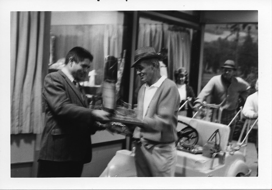
Presentations at Centennial '71 Golf Tournament
https://search.heritageburnaby.ca/link/museumdescription13298
- Repository
- Burnaby Village Museum
- Date
- 11 Sept 1971
- Collection/Fonds
- Donald Copan collection
- Description Level
- Item
- Physical Description
- 1 photograph : b&w ; 8.9 x 12.7 cm
- Scope and Content
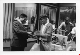
- Photograph of an unidentified man presenting a prize to a golfer during the Centennial '71 Golf Tournament which took place at Burnaby Mountain Golf Course on September 11, 1971.
- Repository
- Burnaby Village Museum
- Collection/Fonds
- Donald Copan collection
- Series
- Copan album series
- Description Level
- Item
- Physical Description
- 1 photograph : b&w ; 8.9 x 12.7 cm
- Scope and Content
- Photograph of an unidentified man presenting a prize to a golfer during the Centennial '71 Golf Tournament which took place at Burnaby Mountain Golf Course on September 11, 1971.
- Geographic Access
- Halifax Street
- Street Address
- 7600 Halifax Street
- Accession Code
- BV005.54.314
- Access Restriction
- No restrictions
- Reproduction Restriction
- May be restricted by third party rights
- Date
- 11 Sept 1971
- Media Type
- Photograph
- Historic Neighbourhood
- Lochdale (Historic Neighbourhood)
- Planning Study Area
- Sperling-Broadway Area
- Scan Resolution
- 600
- Scan Date
- July 23, 2020
- Scale
- 100
- Notes
- Title based on contents of photograph
Images
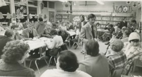
Ray Culos at all-candidates meeting
https://search.heritageburnaby.ca/link/archivedescription56635
- Repository
- City of Burnaby Archives
- Date
- November 1976
- Collection/Fonds
- Columbian Newspaper collection
- Description Level
- Item
- Physical Description
- 1 photograph : b&w ; 10.5 x 18.5 cm
- Scope and Content
- Photograph of Ray Culos handing out material at an all-candidates meeting at Lochdale Community School. He was on the Burnaby Public Library Board from 1966 to 1972 and again from 1986 to 1991. He was also on the Information Burnaby Committee in 1973.
- Repository
- City of Burnaby Archives
- Date
- November 1976
- Collection/Fonds
- Columbian Newspaper collection
- Physical Description
- 1 photograph : b&w ; 10.5 x 18.5 cm
- Description Level
- Item
- Record No.
- 480-250
- Access Restriction
- No restrictions
- Reproduction Restriction
- No restrictions
- Accession Number
- 2003-02
- Scope and Content
- Photograph of Ray Culos handing out material at an all-candidates meeting at Lochdale Community School. He was on the Burnaby Public Library Board from 1966 to 1972 and again from 1986 to 1991. He was also on the Information Burnaby Committee in 1973.
- Media Type
- Photograph
- Photographer
- Battistoni, Peter
- Notes
- Title based on contents of photograph
- Newspaper clipping attached to verso of photograph reads: "Candidates hand out material at Burnaby all-candidates meeting Wednesday at Lochdale School"
- Geographic Access
- Aubrey Street
- Street Address
- 6990 Aubrey Street
- Historic Neighbourhood
- Lochdale (Historic Neighbourhood)
- Planning Study Area
- Lochdale Area
Images


Shack at 7400 Block Halifax Street
https://search.heritageburnaby.ca/link/archivedescription78993
- Repository
- City of Burnaby Archives
- Date
- September 7, 1976
- Collection/Fonds
- Burnaby Public Library Contemporary Visual Archive Project
- Description Level
- Item
- Physical Description
- 1 photograph : b&w ; 11 x 16 cm mounted on cardboard
- Scope and Content
- Photograph shows an old shack in the 7400 Block Halifax Street built in approximately 1930. The shack was a boiler shed for what was then a 40-acre farm specializing in pigs and horses.
- Repository
- City of Burnaby Archives
- Date
- September 7, 1976
- Collection/Fonds
- Burnaby Public Library Contemporary Visual Archive Project
- Physical Description
- 1 photograph : b&w ; 11 x 16 cm mounted on cardboard
- Description Level
- Item
- Record No.
- 556-078
- Access Restriction
- No restrictions
- Reproduction Restriction
- Reproduce for fair dealing purposes only
- Accession Number
- 2013-13
- Scope and Content
- Photograph shows an old shack in the 7400 Block Halifax Street built in approximately 1930. The shack was a boiler shed for what was then a 40-acre farm specializing in pigs and horses.
- Subjects
- Agriculture - Farms
- Media Type
- Photograph
- Photographer
- Born, A. J.
- Notes
- Scope note taken directly from BPL photograph description.
- 1 b&w copy negative : 10 x 12.5 cm accompanying
- Geographic Access
- Halifax Street
- Historic Neighbourhood
- Lochdale (Historic Neighbourhood)
- Planning Study Area
- Sperling-Broadway Area
Images


Shell Oil Company
https://search.heritageburnaby.ca/link/landmark675
- Repository
- Burnaby Heritage Planning
- Geographic Access
- Kensington Avenue
- Associated Dates
- ca. 1930-1993
- Heritage Value
- After considering several sites in the Greater Vancouver area, the Shell Oil Company chose 70 acres in North Burnaby with frontage of one third of a mile on Burrard Inlet. Shell proposed to build a four-million dollar plant that would employ up to 2000 - providing some relief in the middle of Burnaby's economic crisis of the Depression years. The site became known as the Shellburn Refinery and was in operation until 1993.
- Historic Neighbourhood
- Lochdale (Historic Neighbourhood)
- Planning Study Area
- Westridge Area
Images


Sperling Avenue Looking South
https://search.heritageburnaby.ca/link/archivedescription79948
- Repository
- City of Burnaby Archives
- Date
- September 20, 1976
- Collection/Fonds
- Burnaby Public Library Contemporary Visual Archive Project
- Description Level
- Item
- Physical Description
- 1 photograph : b&w ; 11 x 16 cm mounted on cardboard
- Scope and Content
- Photograph shows a view of Sperling Avenue looking south from Broadway.
- Repository
- City of Burnaby Archives
- Date
- September 20, 1976
- Collection/Fonds
- Burnaby Public Library Contemporary Visual Archive Project
- Physical Description
- 1 photograph : b&w ; 11 x 16 cm mounted on cardboard
- Description Level
- Item
- Record No.
- 556-519
- Access Restriction
- No restrictions
- Reproduction Restriction
- Reproduce for fair dealing purposes only
- Accession Number
- 2013-13
- Scope and Content
- Photograph shows a view of Sperling Avenue looking south from Broadway.
- Subjects
- Aerial Photographs
- Media Type
- Photograph
- Photographer
- McCarron, John
- Notes
- Scope note taken directly from BPL photograph description.
- 1 b&w copy negative : 10 x 12.5 cm accompanying
- Geographic Access
- Sperling Avenue
- Historic Neighbourhood
- Lochdale (Historic Neighbourhood)
- Planning Study Area
- Sperling-Broadway Area
Images


Sperling-Broadway Neighbourhood
https://search.heritageburnaby.ca/link/landmark789
- Repository
- Burnaby Heritage Planning
- Associated Dates
- 1955-2008
- Heritage Value
- By the 1970s, the Sperling-Broadway Neighbourhood was characterised as one of the Municipality's fastest growing residential areas. In 1980, it was estimated that slightly less than half of the homes were single-family residences, while the remaining development was taking the form of townhouse and high-rise apartments. The emphasis shifted back to single family housing during the construction of planned subdivisions such as the Camrose subdivision in the 1980s and the area remains primarily residential in nature. The neighbourhood is well-served by park facilities and is also home to the Burnaby Mountain Golf Course.
- Historic Neighbourhood
- Lochdale (Historic Neighbourhood)
- Planning Study Area
- Sperling-Broadway Area
Images


Townhouses in Ellerslie Court
https://search.heritageburnaby.ca/link/archivedescription79018
- Repository
- City of Burnaby Archives
- Date
- September 22, 1976
- Collection/Fonds
- Burnaby Public Library Contemporary Visual Archive Project
- Description Level
- Item
- Physical Description
- 1 photograph : b&w ; 11 x 16 cm mounted on cardboard
- Scope and Content
- Photograph shows townhouses located in the Ellerslie Court development off Lougheed Highway between Sperling Avenue and Bainbridge Avenue.
- Repository
- City of Burnaby Archives
- Date
- September 22, 1976
- Collection/Fonds
- Burnaby Public Library Contemporary Visual Archive Project
- Physical Description
- 1 photograph : b&w ; 11 x 16 cm mounted on cardboard
- Description Level
- Item
- Record No.
- 556-094
- Access Restriction
- No restrictions
- Reproduction Restriction
- Reproduce for fair dealing purposes only
- Accession Number
- 2013-13
- Scope and Content
- Photograph shows townhouses located in the Ellerslie Court development off Lougheed Highway between Sperling Avenue and Bainbridge Avenue.
- Media Type
- Photograph
- Photographer
- McCarron, John
- Notes
- Scope note taken directly from BPL photograph description.
- 1 b&w copy negative : 10 x 12.5 cm accompanying
- Geographic Access
- Ellerslie Avenue
- Historic Neighbourhood
- Lochdale (Historic Neighbourhood)
- Planning Study Area
- Sperling-Broadway Area
Images

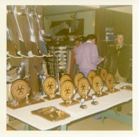
Trophies for Centennial '71 Golf Tournament
https://search.heritageburnaby.ca/link/museumdescription13300
- Repository
- Burnaby Village Museum
- Date
- 11 Sept 1971
- Collection/Fonds
- Donald Copan collection
- Description Level
- Item
- Physical Description
- 1 photograph : col. ; 8.9 x 8.9 cm
- Scope and Content
- Photograph of a display of trophies and awards for the Centennial '71 Golf Tournament which took place at Burnaby Mountain Golf Course on September 11, 1971.
- Repository
- Burnaby Village Museum
- Collection/Fonds
- Donald Copan collection
- Series
- Copan album series
- Description Level
- Item
- Physical Description
- 1 photograph : col. ; 8.9 x 8.9 cm
- Scope and Content
- Photograph of a display of trophies and awards for the Centennial '71 Golf Tournament which took place at Burnaby Mountain Golf Course on September 11, 1971.
- Geographic Access
- Halifax Street
- Street Address
- 7600 Halifax Street
- Accession Code
- BV005.54.316
- Access Restriction
- No restrictions
- Reproduction Restriction
- May be restricted by third party rights
- Date
- 11 Sept 1971
- Media Type
- Photograph
- Historic Neighbourhood
- Lochdale (Historic Neighbourhood)
- Planning Study Area
- Sperling-Broadway Area
- Scan Resolution
- 600
- Scan Date
- July 23, 2020
- Scale
- 100
- Notes
- Title based on contents of photograph
Images
