Narrow Results By
Subject
- Animals - Birds 2
- Buildings - Agricultural - Greenhouses 1
- Buildings - Civic - Hospitals 2
- Buildings - Commercial - Hardware Stores 1
- Buildings - Commercial - Train Stations 1
- Buildings - Heritage 5
- Buildings - Residential - Houses 7
- Buildings - Schools 1
- Clothing - Uniforms 2
- Construction 1
- Geographic Features - Gardens 2
- Geographic Features - Lakes and Ponds 1
Person / Organization
- Armstrong Avenue School 2
- Barnes, Hannah Victoria "Girlie" Love 1
- British Columbia Electric Railway Company 1
- Coutts, Lois Hollands 1
- George Derby Health Centre 4
- Groves, Ada Evelyn Lewis 1
- Hollands, Charles "Charlie" 1
- Hunter, Beatrice "Bea" Carpenter 2
- Jones, Lillian May Davies 1
- Love Family 1
- Love, John Leonard 1
- Massey, Betty 1

George Derby Centre
https://search.heritageburnaby.ca/link/landmark705
- Repository
- Burnaby Heritage Planning
- Geographic Access
- Cumberland Street
- Associated Dates
- 1947
- Heritage Value
- The George Derby Centre was opened in 1947 as a rehabilitation Centre for young disabled veterans returning from the war. The centre was named after George Cleveland Derby, a World War I veteran who was injured in the Battle of Vimy Ridge and later went on to become a District Administrator in the Department of Solders’ Civil Re-establishment, the forerunner of the Department of Veterans Affairs. His work took him to wartime England where he was awarded the Order of the British Empire in 1943 for patriotic and philanthropic work.
- Historic Neighbourhood
- East Burnaby (Historic Neighbourhood)
- Planning Study Area
- Cariboo-Armstrong Area
- Street Address
- 7550 Cumberland Street
- Street View URL
- Google Maps Street View
Images

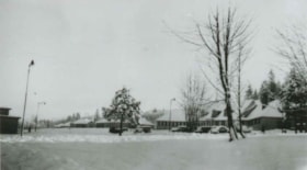
George Derby Health Centre
https://search.heritageburnaby.ca/link/archivedescription37538
- Repository
- City of Burnaby Archives
- Date
- December 20, 1948 (date of original), copied 1991
- Collection/Fonds
- Burnaby Historical Society fonds
- Description Level
- Item
- Physical Description
- 1 photograph : b&w ; 2.9 x 5.2 cm print on contact sheet 20.2 x 25.3 cm
- Scope and Content
- Photograph of the George Derby Health Centre main building and grounds in the snow.
- Repository
- City of Burnaby Archives
- Date
- December 20, 1948 (date of original), copied 1991
- Collection/Fonds
- Burnaby Historical Society fonds
- Subseries
- Burnaby Image Bank subseries
- Physical Description
- 1 photograph : b&w ; 2.9 x 5.2 cm print on contact sheet 20.2 x 25.3 cm
- Description Level
- Item
- Record No.
- 370-126
- Access Restriction
- No restrictions
- Reproduction Restriction
- No known restrictions
- Accession Number
- BHS1999-03
- Scope and Content
- Photograph of the George Derby Health Centre main building and grounds in the snow.
- Subjects
- Buildings - Civic - Hospitals
- Media Type
- Photograph
- Notes
- Title based on contents of photograph
- 1 b&w copy negative accompanying
- Geographic Access
- Cumberland Street
- Street Address
- 7550 Cumberland Street
- Historic Neighbourhood
- East Burnaby (Historic Neighbourhood)
- Planning Study Area
- Cariboo-Armstrong Area
Images

![Greenhouse and storage shed, [between 1933 and 1947] (date of original), copied 2014 thumbnail](/media/hpo/_Data/_Archives_Images/_Unrestricted/580/581-014.jpg?width=280)
Greenhouse and storage shed
https://search.heritageburnaby.ca/link/archivedescription88408
- Repository
- City of Burnaby Archives
- Date
- [between 1933 and 1947] (date of original), copied 2014
- Collection/Fonds
- James Massey family fonds
- Description Level
- Item
- Physical Description
- 1 photograph (tiff) : sepia ; 600 dpi
- Scope and Content
- Photograph of a green house and storage shed in Robert Burnaby Park. The greenhouse was built by James Massey and was used as nursery for the gardens within the park. James was the caretaker and resided with his family in the park from 1933 until 1947.
- Repository
- City of Burnaby Archives
- Date
- [between 1933 and 1947] (date of original), copied 2014
- Collection/Fonds
- James Massey family fonds
- Physical Description
- 1 photograph (tiff) : sepia ; 600 dpi
- Description Level
- Item
- Record No.
- 581-014
- Access Restriction
- No restrictions
- Reproduction Restriction
- No known restrictions
- Accession Number
- 2014-34
- Scope and Content
- Photograph of a green house and storage shed in Robert Burnaby Park. The greenhouse was built by James Massey and was used as nursery for the gardens within the park. James was the caretaker and resided with his family in the park from 1933 until 1947.
- Media Type
- Photograph
- Notes
- Title based on contents of photograph
- Historic Neighbourhood
- East Burnaby (Historic Neighbourhood)
- Planning Study Area
- Lakeview-Mayfield Area
Images
![Greenhouse and storage shed, [between 1933 and 1947] (date of original), copied 2014 thumbnail](/media/hpo/_Data/_Archives_Images/_Unrestricted/580/581-014.jpg)

House construction on 12th Avenue
https://search.heritageburnaby.ca/link/archivedescription38201
- Repository
- City of Burnaby Archives
- Date
- 1946 (date of original), copied 1991
- Collection/Fonds
- Burnaby Historical Society fonds
- Description Level
- Item
- Physical Description
- 1 photograph : b&w ; 2.9 x 4.9 cm print on contact sheet 20.3 x 26.6 cm
- Scope and Content
- Photograph of the forms for a house under construction at 12th Avenue and 1st Street. A woman is standing at the centre, and a man is at the back left.
- Repository
- City of Burnaby Archives
- Date
- 1946 (date of original), copied 1991
- Collection/Fonds
- Burnaby Historical Society fonds
- Subseries
- Burnaby Image Bank subseries
- Physical Description
- 1 photograph : b&w ; 2.9 x 4.9 cm print on contact sheet 20.3 x 26.6 cm
- Description Level
- Item
- Record No.
- 370-788
- Access Restriction
- No restrictions
- Reproduction Restriction
- No known restrictions
- Accession Number
- BHS1999-03
- Scope and Content
- Photograph of the forms for a house under construction at 12th Avenue and 1st Street. A woman is standing at the centre, and a man is at the back left.
- Media Type
- Photograph
- Notes
- Title based on contents of photograph
- 1 b&w copy negative accompanying
- Geographic Access
- 12th Avenue
- 1st Street
- Historic Neighbourhood
- East Burnaby (Historic Neighbourhood)
- Planning Study Area
- Second Street Area
Images

![James Massey, [between 1933 and 1948] (date of original), copied 2015 thumbnail](/media/hpo/_Data/_Archives_Images/_Unrestricted/580/581-018.jpg?width=280)
James Massey
https://search.heritageburnaby.ca/link/archivedescription88830
- Repository
- City of Burnaby Archives
- Date
- [between 1933 and 1948] (date of original), copied 2015
- Collection/Fonds
- James Massey family fonds
- Description Level
- Item
- Physical Description
- 1 photograph (tiff) : sepia ; 600 dpi
- Scope and Content
- Photograph portrait of the James Massey.
- Repository
- City of Burnaby Archives
- Date
- [between 1933 and 1948] (date of original), copied 2015
- Collection/Fonds
- James Massey family fonds
- Physical Description
- 1 photograph (tiff) : sepia ; 600 dpi
- Description Level
- Item
- Record No.
- 581-018
- Access Restriction
- No restrictions
- Reproduction Restriction
- No restrictions
- Accession Number
- 2014-34
- Scope and Content
- Photograph portrait of the James Massey.
- Names
- Massey, James
- Media Type
- Photograph
- Notes
- Title based on contents of photograph
- Historic Neighbourhood
- East Burnaby (Historic Neighbourhood)
- Planning Study Area
- Lakeview-Mayfield Area
Images
![James Massey, [between 1933 and 1948] (date of original), copied 2015 thumbnail](/media/hpo/_Data/_Archives_Images/_Unrestricted/580/581-018.jpg)
![James Massey Home, [between 1933 and 1948] (date of original), copied 2015 thumbnail](/media/hpo/_Data/_Archives_Images/_Unrestricted/580/581-017.jpg?width=280)
James Massey Home
https://search.heritageburnaby.ca/link/archivedescription88829
- Repository
- City of Burnaby Archives
- Date
- [between 1933 and 1948] (date of original), copied 2015
- Collection/Fonds
- James Massey family fonds
- Description Level
- Item
- Physical Description
- 1 photograph (tiff) : sepia ; 600 dpi
- Scope and Content
- Photograph of the James Massey home in Robert Burnaby Park with a huge cannas plant and garden surrounding it.
- Repository
- City of Burnaby Archives
- Date
- [between 1933 and 1948] (date of original), copied 2015
- Collection/Fonds
- James Massey family fonds
- Physical Description
- 1 photograph (tiff) : sepia ; 600 dpi
- Description Level
- Item
- Record No.
- 581-017
- Access Restriction
- No restrictions
- Reproduction Restriction
- No known restrictions
- Accession Number
- 2014-34
- Scope and Content
- Photograph of the James Massey home in Robert Burnaby Park with a huge cannas plant and garden surrounding it.
- Media Type
- Photograph
- Notes
- Title based on contents of photograph
- Historic Neighbourhood
- East Burnaby (Historic Neighbourhood)
- Planning Study Area
- Lakeview-Mayfield Area
Images
![James Massey Home, [between 1933 and 1948] (date of original), copied 2015 thumbnail](/media/hpo/_Data/_Archives_Images/_Unrestricted/580/581-017.jpg)
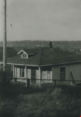
Klub family home
https://search.heritageburnaby.ca/link/archivedescription36814
- Repository
- City of Burnaby Archives
- Date
- 1944 (date of original), copied 1992
- Collection/Fonds
- Burnaby Historical Society fonds
- Description Level
- Item
- Physical Description
- 1 photograph : b&w ; 8.8 x 12.7 cm print
- Scope and Content
- Photograph of the Klub family home at 562 Craig Avenue (old street numbering system) looking north toward Coquitlam.
- Repository
- City of Burnaby Archives
- Date
- 1944 (date of original), copied 1992
- Collection/Fonds
- Burnaby Historical Society fonds
- Subseries
- Burnaby Centennial Anthology subseries
- Physical Description
- 1 photograph : b&w ; 8.8 x 12.7 cm print
- Description Level
- Item
- Record No.
- 315-272
- Access Restriction
- No restrictions
- Reproduction Restriction
- No known restrictions
- Accession Number
- BHS1994-04
- Scope and Content
- Photograph of the Klub family home at 562 Craig Avenue (old street numbering system) looking north toward Coquitlam.
- Subjects
- Buildings - Residential - Houses
- Media Type
- Photograph
- Notes
- Title based on contents of photograph
- Geographic Access
- Craig Avenue
- Street Address
- 7620 Craig Avenue
- Historic Neighbourhood
- East Burnaby (Historic Neighbourhood)
- Planning Study Area
- Cariboo-Armstrong Area
Images

![Lois Hollands-Coutts and Charles Hollands, [1945] (date of original), copied 1991 thumbnail](/media/hpo/_Data/_Archives_Images/_Unrestricted/370/370-429.jpg?width=280)
Lois Hollands-Coutts and Charles Hollands
https://search.heritageburnaby.ca/link/archivedescription37841
- Repository
- City of Burnaby Archives
- Date
- [1945] (date of original), copied 1991
- Collection/Fonds
- Burnaby Historical Society fonds
- Description Level
- Item
- Physical Description
- 1 photograph : b&w ; 4.1 x 2.8 cm print on contact sheet 20.6 x 26.7 cm
- Scope and Content
- Photograph of Lois Holland-Coutts and her father, Charles Hollands, on a path leading to Robert Burnaby Park, near 6th Street at 19th Avenue.
- Repository
- City of Burnaby Archives
- Date
- [1945] (date of original), copied 1991
- Collection/Fonds
- Burnaby Historical Society fonds
- Subseries
- Burnaby Image Bank subseries
- Physical Description
- 1 photograph : b&w ; 4.1 x 2.8 cm print on contact sheet 20.6 x 26.7 cm
- Description Level
- Item
- Record No.
- 370-429
- Access Restriction
- No restrictions
- Reproduction Restriction
- No known restrictions
- Accession Number
- BHS1999-03
- Scope and Content
- Photograph of Lois Holland-Coutts and her father, Charles Hollands, on a path leading to Robert Burnaby Park, near 6th Street at 19th Avenue.
- Media Type
- Photograph
- Notes
- Title based on contents of photograph
- 1 b&w copy negative accompanying
- Negative has a pink cast
- Geographic Access
- 6th Street
- 19th Avenue
- Historic Neighbourhood
- East Burnaby (Historic Neighbourhood)
- Planning Study Area
- Second Street Area
Images
![Lois Hollands-Coutts and Charles Hollands, [1945] (date of original), copied 1991 thumbnail](/media/hpo/_Data/_Archives_Images/_Unrestricted/370/370-429.jpg)
![Lot clearing for Westminster Gospel Chapel, [between 1945 and 1949] (date of original), copied 1991 thumbnail](/media/hpo/_Data/_Archives_Images/_Unrestricted/370/370-415.jpg?width=280)
Lot clearing for Westminster Gospel Chapel
https://search.heritageburnaby.ca/link/archivedescription37827
- Repository
- City of Burnaby Archives
- Date
- [between 1945 and 1949] (date of original), copied 1991
- Collection/Fonds
- Burnaby Historical Society fonds
- Description Level
- Item
- Physical Description
- 1 photograph : b&w ; 2.7 x 4.7 cm print on contact sheet 20.6 x 26.2 cm
- Scope and Content
- Photograph of people clearing a lot to build Westminster Gospel Chapel at 7540 6th Street.
- Repository
- City of Burnaby Archives
- Date
- [between 1945 and 1949] (date of original), copied 1991
- Collection/Fonds
- Burnaby Historical Society fonds
- Subseries
- Burnaby Image Bank subseries
- Physical Description
- 1 photograph : b&w ; 2.7 x 4.7 cm print on contact sheet 20.6 x 26.2 cm
- Description Level
- Item
- Record No.
- 370-415
- Access Restriction
- No restrictions
- Reproduction Restriction
- No known restrictions
- Accession Number
- BHS1999-03
- Scope and Content
- Photograph of people clearing a lot to build Westminster Gospel Chapel at 7540 6th Street.
- Subjects
- Land Clearing
- Media Type
- Photograph
- Notes
- Title based on contents of photograph
- 1 b&w copy negative accompanying
- Negative has a pink cast
- Geographic Access
- 6th Street
- Street Address
- 7540 6th Street
- Historic Neighbourhood
- East Burnaby (Historic Neighbourhood)
- Planning Study Area
- Second Street Area
Images
![Lot clearing for Westminster Gospel Chapel, [between 1945 and 1949] (date of original), copied 1991 thumbnail](/media/hpo/_Data/_Archives_Images/_Unrestricted/370/370-415.jpg)
![Lot clearing for Westminster Gospel Chapel, [between 1945 and 1949] (date of original), copied 1991 thumbnail](/media/hpo/_Data/_Archives_Images/_Unrestricted/370/370-416.jpg?width=280)
Lot clearing for Westminster Gospel Chapel
https://search.heritageburnaby.ca/link/archivedescription37828
- Repository
- City of Burnaby Archives
- Date
- [between 1945 and 1949] (date of original), copied 1991
- Collection/Fonds
- Burnaby Historical Society fonds
- Description Level
- Item
- Physical Description
- 1 photograph : b&w ; 2.6 x 4.7 cm print on contact sheet 20.6 x 26.2 cm
- Scope and Content
- Photograph of people clearing a lot to build Westminster Gospel Chapel at 7540 6th Street. Houses can be seen in the background, and the road can be seen in the foreground.
- Repository
- City of Burnaby Archives
- Date
- [between 1945 and 1949] (date of original), copied 1991
- Collection/Fonds
- Burnaby Historical Society fonds
- Subseries
- Burnaby Image Bank subseries
- Physical Description
- 1 photograph : b&w ; 2.6 x 4.7 cm print on contact sheet 20.6 x 26.2 cm
- Description Level
- Item
- Record No.
- 370-416
- Access Restriction
- No restrictions
- Reproduction Restriction
- No known restrictions
- Accession Number
- BHS1999-03
- Scope and Content
- Photograph of people clearing a lot to build Westminster Gospel Chapel at 7540 6th Street. Houses can be seen in the background, and the road can be seen in the foreground.
- Subjects
- Land Clearing
- Media Type
- Photograph
- Notes
- Title based on contents of photograph
- 1 b&w copy negative accompanying
- Negative has a pink cast
- Geographic Access
- 6th Street
- Street Address
- 7540 6th Street
- Historic Neighbourhood
- East Burnaby (Historic Neighbourhood)
- Planning Study Area
- Second Street Area
Images
![Lot clearing for Westminster Gospel Chapel, [between 1945 and 1949] (date of original), copied 1991 thumbnail](/media/hpo/_Data/_Archives_Images/_Unrestricted/370/370-416.jpg)
![Love barn in winter, [between 1930 and 1940] (date of original), copied 1998 thumbnail](/media/hpo/_Data/_BVM_Images/2018/2018_0041_0180_001.jpg?width=280)
Love barn in winter
https://search.heritageburnaby.ca/link/museumdescription9995
- Repository
- Burnaby Village Museum
- Date
- [between 1930 and 1940] (date of original), copied 1998
- Collection/Fonds
- Burnaby Village Museum fonds
- Description Level
- Item
- Physical Description
- 1 photograph : b&w negative ; 35 mm
- Scope and Content
- Photograph of the Love barn surrounded by a large snow banks with trees and a weather vane popping out of it .The corner of the Love farmhouse back porch is on the right. In 1928 after Sarah Parker's father, Jesse Love died, William and Sarah (nee Love) Parker purchased the Love farmhouse located a…
- Repository
- Burnaby Village Museum
- Collection/Fonds
- Burnaby Village Museum fonds
- Series
- Jesse Love farmhouse series
- Subseries
- Love family photographs subseries
- Description Level
- Item
- Physical Description
- 1 photograph : b&w negative ; 35 mm
- Scope and Content
- Photograph of the Love barn surrounded by a large snow banks with trees and a weather vane popping out of it .The corner of the Love farmhouse back porch is on the right. In 1928 after Sarah Parker's father, Jesse Love died, William and Sarah (nee Love) Parker purchased the Love farmhouse located at 1390 Cumberland Road. They lived there until 1961, with their three children; Albert, Bill and Elsie. Jesse and Martha Love were the orignal owners of the house where they raised eleven children.
- Subjects
- Natural Phenomena - Snow
- Geographic Access
- Cumberland Street
- Street Address
- 7651 Cumberland Street
- Accession Code
- BV018.41.180
- Access Restriction
- No restrictions
- Reproduction Restriction
- May be restricted by third party rights
- Date
- [between 1930 and 1940] (date of original), copied 1998
- Media Type
- Photograph
- Historic Neighbourhood
- East Burnaby (Historic Neighbourhood)
- Planning Study Area
- Cariboo-Armstrong Area
- Scan Resolution
- 2400
- Scan Date
- 4-Mar-2019
- Scale
- 100
- Photographer
- Parker, Albert "Bert"
- Notes
- Title based on contents of photograph
- 1 b&w copy print accompanying
Images
![Love barn in winter, [between 1930 and 1940] (date of original), copied 1998 thumbnail](/media/hpo/_Data/_BVM_Images/2018/2018_0041_0180_001.jpg)
![Love farmhouse in winter, [between 1930 and 1940] (date of original), copied 1998 thumbnail](/media/hpo/_Data/_BVM_Images/2018/2018_0041_0172_001.jpg?width=280)
Love farmhouse in winter
https://search.heritageburnaby.ca/link/museumdescription9987
- Repository
- Burnaby Village Museum
- Date
- [between 1930 and 1940] (date of original), copied 1998
- Collection/Fonds
- Burnaby Village Museum fonds
- Description Level
- Item
- Physical Description
- 1 photograph : b&w negative ; 35 mm
- Scope and Content
- Photograph of the front of the Love farmhouse surrounded by snow with icicles hanging from the front porch and snow on the rooftops. There is a wire fence with a gate in front of the house. In 1928 after Sarah Parker's father, Jesse Love died, William and Sarah (nee Love) Parker purchased the Love …
- Repository
- Burnaby Village Museum
- Collection/Fonds
- Burnaby Village Museum fonds
- Series
- Jesse Love farmhouse series
- Subseries
- Love family photographs subseries
- Description Level
- Item
- Physical Description
- 1 photograph : b&w negative ; 35 mm
- Scope and Content
- Photograph of the front of the Love farmhouse surrounded by snow with icicles hanging from the front porch and snow on the rooftops. There is a wire fence with a gate in front of the house. In 1928 after Sarah Parker's father, Jesse Love died, William and Sarah (nee Love) Parker purchased the Love farmhouse located at 1390 Cumberland Road. They lived there until 1961, with their three children; Albert, Bill and Elsie. Jesse and Martha Love were the orignal owners of the house where they raised eleven children.
- Subjects
- Natural Phenomena - Snow
- Geographic Access
- Cumberland Street
- Street Address
- 7651 Cumberland Street
- Accession Code
- BV018.41.172
- Access Restriction
- No restrictions
- Reproduction Restriction
- May be restricted by third party rights
- Date
- [between 1930 and 1940] (date of original), copied 1998
- Media Type
- Photograph
- Historic Neighbourhood
- East Burnaby (Historic Neighbourhood)
- Planning Study Area
- Cariboo-Armstrong Area
- Scan Resolution
- 2400
- Scan Date
- 4-Mar-2019
- Scale
- 100
- Photographer
- Parker, Albert "Bert"
- Notes
- Title based on contents of photograph
- See BV988.33.34 for description of artifact
- 1 b&w copy print accompanying
Images
![Love farmhouse in winter, [between 1930 and 1940] (date of original), copied 1998 thumbnail](/media/hpo/_Data/_BVM_Images/2018/2018_0041_0172_001.jpg)
![Love farmhouse in winter, [between 1930 and 1940] (date of original), copied 1998 thumbnail](/media/hpo/_Data/_BVM_Images/2018/2018_0041_0179_001.jpg?width=280)
Love farmhouse in winter
https://search.heritageburnaby.ca/link/museumdescription9994
- Repository
- Burnaby Village Museum
- Date
- [between 1930 and 1940] (date of original), copied 1998
- Collection/Fonds
- Burnaby Village Museum fonds
- Description Level
- Item
- Physical Description
- 1 photograph : b&w negative ; 35 mm
- Scope and Content
- Photograph of the rear of the Love farmhouse surrounded by a large snow bank. There are icicles hanging from the rooftop of the main house and kitchen porch. In 1928 after Sarah Parker's father, Jesse Love died, William and Sarah (nee Love) Parker purchased the Love farmhouse located at 1390 Cumbe…
- Repository
- Burnaby Village Museum
- Collection/Fonds
- Burnaby Village Museum fonds
- Series
- Jesse Love farmhouse series
- Subseries
- Love family photographs subseries
- Description Level
- Item
- Physical Description
- 1 photograph : b&w negative ; 35 mm
- Scope and Content
- Photograph of the rear of the Love farmhouse surrounded by a large snow bank. There are icicles hanging from the rooftop of the main house and kitchen porch. In 1928 after Sarah Parker's father, Jesse Love died, William and Sarah (nee Love) Parker purchased the Love farmhouse located at 1390 Cumberland Road. They lived there until 1961, with their three children; Albert, Bill and Elsie. Jesse and Martha Love were the orignal owners of the house where they raised eleven children.
- Subjects
- Natural Phenomena - Snow
- Geographic Access
- Cumberland Street
- Street Address
- 7651 Cumberland Street
- Accession Code
- BV018.41.179
- Access Restriction
- No restrictions
- Reproduction Restriction
- May be restricted by third party rights
- Date
- [between 1930 and 1940] (date of original), copied 1998
- Media Type
- Photograph
- Historic Neighbourhood
- East Burnaby (Historic Neighbourhood)
- Planning Study Area
- Cariboo-Armstrong Area
- Scan Resolution
- 2400
- Scan Date
- 4-Mar-2019
- Scale
- 100
- Photographer
- Parker, Albert "Bert"
- Notes
- Title based on contents of photograph
- 1 b&w copy print accompanying
Images
![Love farmhouse in winter, [between 1930 and 1940] (date of original), copied 1998 thumbnail](/media/hpo/_Data/_BVM_Images/2018/2018_0041_0179_001.jpg)
![Massey residence, [between 1933 and 1948] (date of original), copied 2015 thumbnail](/media/hpo/_Data/_Archives_Images/_Unrestricted/580/581-015.jpg?width=280)
Massey residence
https://search.heritageburnaby.ca/link/archivedescription88827
- Repository
- City of Burnaby Archives
- Date
- [between 1933 and 1948] (date of original), copied 2015
- Collection/Fonds
- James Massey family fonds
- Description Level
- Item
- Physical Description
- 1 photograph (tiff) : sepia ; 600 dpi
- Scope and Content
- Photograph of the Massey family residence in Robert Burnaby Park. The house is surrounded by trees and has a fish pond in the front yard. After the Massey family moved out, the house was rented by Jack and Daphne Shaw (Burnaby clerk), followed by Roy and Grace McKay. In the late 1950s or early 1960…
- Repository
- City of Burnaby Archives
- Date
- [between 1933 and 1948] (date of original), copied 2015
- Collection/Fonds
- James Massey family fonds
- Physical Description
- 1 photograph (tiff) : sepia ; 600 dpi
- Description Level
- Item
- Record No.
- 581-015
- Access Restriction
- No restrictions
- Reproduction Restriction
- No known restrictions
- Accession Number
- 2014-34
- Scope and Content
- Photograph of the Massey family residence in Robert Burnaby Park. The house is surrounded by trees and has a fish pond in the front yard. After the Massey family moved out, the house was rented by Jack and Daphne Shaw (Burnaby clerk), followed by Roy and Grace McKay. In the late 1950s or early 1960s, the house was burned down by the Burnaby Fire Department during a fire practice.
- Media Type
- Photograph
- Notes
- Title based on contents of photograph
- Historic Neighbourhood
- East Burnaby (Historic Neighbourhood)
- Planning Study Area
- Lakeview-Mayfield Area
Images
![Massey residence, [between 1933 and 1948] (date of original), copied 2015 thumbnail](/media/hpo/_Data/_Archives_Images/_Unrestricted/580/581-015.jpg)
![Parker family tennis court, [between 1930 and 1940] (date of original), copied 1998 thumbnail](/media/hpo/_Data/_BVM_Images/2018/2018_0041_0175_001.jpg?width=280)
Parker family tennis court
https://search.heritageburnaby.ca/link/museumdescription9984
- Repository
- Burnaby Village Museum
- Date
- [between 1930 and 1940] (date of original), copied 1998
- Collection/Fonds
- Burnaby Village Museum fonds
- Description Level
- Item
- Physical Description
- 1 photograph : b&w negative ; 35 mm
- Scope and Content
- Photograph of members of the Parker family and friends holding tennis rackets and standing on a tennis court at 1390 Cumberland Road. People are identified from L to R as; Lucy Deacon, Sid Batton, Walter Harris, Elsie Parker, Maud, Albert Parker, Bill Parker, Elsie Parker, Jo Harris and William Par…
- Repository
- Burnaby Village Museum
- Collection/Fonds
- Burnaby Village Museum fonds
- Series
- Jesse Love farmhouse series
- Subseries
- Love family photographs subseries
- Description Level
- Item
- Physical Description
- 1 photograph : b&w negative ; 35 mm
- Scope and Content
- Photograph of members of the Parker family and friends holding tennis rackets and standing on a tennis court at 1390 Cumberland Road. People are identified from L to R as; Lucy Deacon, Sid Batton, Walter Harris, Elsie Parker, Maud, Albert Parker, Bill Parker, Elsie Parker, Jo Harris and William Parker. The tennis court was built by William Parker with help from his son Albert. The court was first made of dirt, then grass with wood layed across to flatten it out. In the late 1920s William made the court out of wood. William and Sarah (nee Love) Parker purchased the Love farmhouse at 1390 Cumberland Road in 1928 after Sarah's father, Jesse Love died. William and Sarah lived there with their three children Albert, Bill and Elsie until 1961.
- Subjects
- Buildings - Heritage
- Geographic Access
- Cumberland Street
- Street Address
- 7651 Cumberland Street
- Accession Code
- BV018.41.175
- Access Restriction
- No restrictions
- Reproduction Restriction
- May be restricted by third party rights
- Date
- [between 1930 and 1940] (date of original), copied 1998
- Media Type
- Photograph
- Historic Neighbourhood
- East Burnaby (Historic Neighbourhood)
- Planning Study Area
- Cariboo-Armstrong Area
- Scan Resolution
- 2400
- Scan Date
- 4-Mar-2019
- Scale
- 100
- Notes
- Title based on contents of photograph
- 1 b&w copy print accompanying
Images
![Parker family tennis court, [between 1930 and 1940] (date of original), copied 1998 thumbnail](/media/hpo/_Data/_BVM_Images/2018/2018_0041_0175_001.jpg)
![Parkers at pond, [between 1930 and 1940] (date of original), copied 1998 thumbnail](/media/hpo/_Data/_BVM_Images/2018/2018_0041_0168_001.jpg?width=280)
Parkers at pond
https://search.heritageburnaby.ca/link/museumdescription9982
- Repository
- Burnaby Village Museum
- Date
- [between 1930 and 1940] (date of original), copied 1998
- Collection/Fonds
- Burnaby Village Museum fonds
- Description Level
- Item
- Physical Description
- 1 photograph : sepia print ; 10.5 x 18 cm
- Scope and Content
- Photograph of four women and three men sitting outside of the Love farmhouse at 1390 Cumberland Road. The group is sitting amongst large rocks and a small pond. The kitchen of the Love farmhouse and the barn are behind them. A few of the people are holding tennis rackets. In 1928 after Sarah Parke…
- Repository
- Burnaby Village Museum
- Collection/Fonds
- Burnaby Village Museum fonds
- Series
- Jesse Love farmhouse series
- Subseries
- Love family photographs subseries
- Description Level
- Item
- Physical Description
- 1 photograph : sepia print ; 10.5 x 18 cm
- Scope and Content
- Photograph of four women and three men sitting outside of the Love farmhouse at 1390 Cumberland Road. The group is sitting amongst large rocks and a small pond. The kitchen of the Love farmhouse and the barn are behind them. A few of the people are holding tennis rackets. In 1928 after Sarah Parker's father, Jesse Love died, William and Sarah (nee Love) Parker purchased the Love farmhouse located at 1390 Cumberland Road. They lived there until 1961, with their three children; Albert, Bill and Elsie.
- Subjects
- Buildings - Heritage
- Sports - Tennis
- Geographic Access
- Cumberland Street
- Street Address
- 7651 Cumberland Street
- Accession Code
- BV018.41.168
- Access Restriction
- No restrictions
- Reproduction Restriction
- May be restricted by third party rights
- Date
- [between 1930 and 1940] (date of original), copied 1998
- Media Type
- Photograph
- Historic Neighbourhood
- East Burnaby (Historic Neighbourhood)
- Planning Study Area
- Cariboo-Armstrong Area
- Scan Resolution
- 600
- Scan Date
- 25-Feb-2019
- Scale
- 100
- Notes
- Title based on contents of photograph
- Photograph was copied from the Albert Parker photograph album in 1998
Images
![Parkers at pond, [between 1930 and 1940] (date of original), copied 1998 thumbnail](/media/hpo/_Data/_BVM_Images/2018/2018_0041_0168_001.jpg)
Pioneer Days interviews September 22, 1971 - Track 1
https://search.heritageburnaby.ca/link/oralhistory266
- Repository
- City of Burnaby Archives
- Date Range
- 1891-1955
- Length
- 0:05:35
- Summary
- This portion of the recording includes Lillian May (Davies) Jones's memories of her family life during the early days of Burnaby, mentioning her family home as well as the home of Reeve Shaw. Lillian is being interviewed in front of an audience at Heritage Village (now Burnaby Village Museum).
- Repository
- City of Burnaby Archives
- Summary
- This portion of the recording includes Lillian May (Davies) Jones's memories of her family life during the early days of Burnaby, mentioning her family home as well as the home of Reeve Shaw. Lillian is being interviewed in front of an audience at Heritage Village (now Burnaby Village Museum).
- Date Range
- 1891-1955
- Length
- 0:05:35
- Historic Neighbourhood
- East Burnaby (Historic Neighbourhood)
- Planning Study Area
- Second Street Area
- Interview Date
- September 22, 1971
- Scope and Content
- Recording is of interviews with Lillian May (Davies) Jones, Ada Evelyn (Lewis) Groves, Lillian Frederica (Lewis) Porter, and Elsie Wilson during the Pioneer Days celebration at Heritage Village (now Burnaby Village Museum) on September 22, 1971. Major themes discussed are: personal memories and occupations of interviewees family members.
- Biographical Notes
- Lillian May Davies was born June 28, 1891 to George and Rachel (Mills) Davies. She was one of four children. George Davies married Rachel Mills September 12, 1888 in Winnipeg and headed west to make their home. George’s brother Richard Davies had already bought property at the corner of 16th Street and 3rd Avenue (now 12th Avenue) when Rachel and George moved in and built a house next door. George Davies went to work for Gilley Bros. Logging Co. in Burnaby. Lillian May Davies married John Henry Jones on July 29, 1909 at the Methodist Church in Burnaby which had opened only a few weeks before (the Joneses were the first couple to be married there). Their reception was held in the Davies’ family garden. On June 3, 1910, Lillian and John’s first child, Arnold Jones was born. In 1919 they adopted their second child, John Sheldon Jones whose birth parents had died of influenza. John and Lillian built a home on the lot next to Lillian’s parents and lived there for forty-eight years. After her husband’s death in 1956, Lillian moved one lot over and remained living there for over twenty years. Lillian May (Davies) Jones died in Surrey on June 24, 1981 at the age of eighty-nine for over twenty years. Lillian May (Davies) Jones died in Surrey on June 24, 1981 at the age of eighty-nine. Ada Evelyn Lewis was born on September 11, 1899. She was one of nine Lewis children. Ada's father came to Victoria BC from San Francisco. He met his wife in Victoria and moved to New Westminster where he was a typesetter on the first edition of the Columbian newspaper. He continued to work for the Columbian until his retirement. Her family owned the East Burnaby Fruit Farm at 17th Avenue between 2nd and 4th Street where they harvested apples, plums and pears. Ada attended East Burnaby School in 1905 and remembers being a pupil of Miss Draper. Ada E. Lewis married and became Mrs. Ada Evelyn Groves. Lillian Frederica “Lillie” Lewis was born in 1896 to William Henry and Emma (Smith) Lewis at the family farm at 4th Street and 18th Avenue. The family grew to nine, eldest to youngest; Albert, Lizzie, Minnie, Walter, Ernest, Lillie and Evelyn. Lillie’s mother, Emma (Smith) had the distinction of being the first girl of European descent to be born at Fort Victoria. Lillie’s father, William Henry Lewis helped to print the very first edition of the Vancouver Province in 1898. Lillie attended Douglas Road School and remembers being a pupil of Ellen Lister. Lillian Frederica “Lillie” Lewis married Bertie Blaine Porter at Lulu Island on November 7, 1918. They lived in Vancouver for a short time before returning to Burnaby to raise their four children. For most of his working life Bert operated a steam roller for the municipality. Lillian Frederica (Lewis) Porter died May 18, 1988 at the age of ninety-two. Elsie Wilson was born August 16, 1898 to Annie and her second husband William Wilson. Annie’s first husband Samuel W Walmsley died December 20, 1895 at the age of thirty-five, leaving Annie a widow at twenty-seven with two young children Annie age four and Samuel age six. Annie Walmsley married her second husband William Wilson on April 17, 1897. Elsie attended West Burnaby public school (later Kingsway West elementary) and remembers picking raspberries at various Burnaby farms for seven seasons.
- Total Tracks
- 4
- Total Length
- 0:24:19
- Interviewee Name
- Jones, Lillian May Davies
- Wilson, Elsie
- Porter, Lillie Lewis
- Groves, Ada Evelyn Lewis
- Interview Location
- Burnaby Village Museum, Burnaby
- Collection/Fonds
- Burnaby Historical Society fonds
- Subseries
- Oral history subseries
- Transcript Available
- None
- Media Type
- Sound Recording
- Web Notes
- Interview was digitized in 2010 allowing it to be accessible on Heritage Burnaby. The digitization project was initiated by the Community Heritage Commission with support from City of Burnaby Council and the BC History Digitization Program of the Irving K. Barber Learning Centre, University of British Columbia. It was recognized by the Heritage Society of BC with an award in 2012.
Audio Tracks
Track one of recording of Pioneer Days interviews
Track one of recording of Pioneer Days interviews
https://search.heritageburnaby.ca/media/hpo/_Data/_Archives_Oral_Histories/_Unrestricted/MSS137-020/MSS137-020_Track_1.mp3![Raising the flag, [between 1939 and 1947] (date of original), copied 2014 thumbnail](/media/hpo/_Data/_Archives_Images/_Unrestricted/580/581-006.jpg?width=280)
Raising the flag
https://search.heritageburnaby.ca/link/archivedescription88400
- Repository
- City of Burnaby Archives
- Date
- [between 1939 and 1947] (date of original), copied 2014
- Collection/Fonds
- James Massey family fonds
- Description Level
- Item
- Physical Description
- 1 photograph (tiff) : sepia ; 600 dpi
- Scope and Content
- Photograph of James Massey as he raises the Union Jack flag up the flag pole in Robert Burnaby Park. James Massey was the caretaker of the park from 1933 until 1947 and raised the flag on all public holidays.
- Repository
- City of Burnaby Archives
- Date
- [between 1939 and 1947] (date of original), copied 2014
- Collection/Fonds
- James Massey family fonds
- Physical Description
- 1 photograph (tiff) : sepia ; 600 dpi
- Description Level
- Item
- Record No.
- 581-006
- Access Restriction
- No restrictions
- Reproduction Restriction
- No restrictions
- Accession Number
- 2014-34
- Scope and Content
- Photograph of James Massey as he raises the Union Jack flag up the flag pole in Robert Burnaby Park. James Massey was the caretaker of the park from 1933 until 1947 and raised the flag on all public holidays.
- Subjects
- Symbols - Flags
- Names
- Massey, James
- Media Type
- Photograph
- Notes
- Title based on contents of photograph
- Historic Neighbourhood
- East Burnaby (Historic Neighbourhood)
- Planning Study Area
- Lakeview-Mayfield Area
Images
![Raising the flag, [between 1939 and 1947] (date of original), copied 2014 thumbnail](/media/hpo/_Data/_Archives_Images/_Unrestricted/580/581-006.jpg)
![Sarah Parker in yard, [194-] thumbnail](/media/hpo/_Data/_BVM_Images/2019/2019_0008_0005_001.jpg?width=280)
Sarah Parker in yard
https://search.heritageburnaby.ca/link/museumdescription18825
- Repository
- Burnaby Village Museum
- Date
- [194-]
- Collection/Fonds
- Love family fonds
- Description Level
- Item
- Physical Description
- 1 photograph : sepia ; 12 x 7.5 cm
- Scope and Content
- Photograph of Sarah (Love) Parker standing in the yard of the Love farmhouse on Cumberland Road in Burnaby.
- Repository
- Burnaby Village Museum
- Collection/Fonds
- Love family fonds
- Description Level
- Item
- Physical Description
- 1 photograph : sepia ; 12 x 7.5 cm
- Scope and Content
- Photograph of Sarah (Love) Parker standing in the yard of the Love farmhouse on Cumberland Road in Burnaby.
- Names
- Parker, Sarah Maria Love
- Geographic Access
- Cumberland Street
- Street Address
- 7651 Cumberland Street
- Accession Code
- BV019.8.5
- Access Restriction
- No restrictions
- Reproduction Restriction
- No known restrictions
- Date
- [194-]
- Media Type
- Photograph
- Historic Neighbourhood
- East Burnaby (Historic Neighbourhood)
- Planning Study Area
- Cariboo-Armstrong Area
- Scan Resolution
- 600
- Scan Date
- 2022-07-07
- Notes
- Title based on contents of photograph
Images
![Sarah Parker in yard, [194-] thumbnail](/media/hpo/_Data/_BVM_Images/2019/2019_0008_0005_001.jpg)

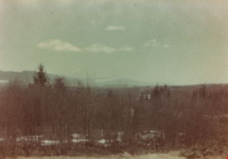
Taken from Armstrong Avenue School
https://search.heritageburnaby.ca/link/archivedescription35044
- Repository
- City of Burnaby Archives
- Date
- 1949 (date of original), copied 1986
- Collection/Fonds
- Burnaby Historical Society fonds
- Description Level
- Item
- Physical Description
- 1 photograph : col. ; 8.8 x 12.5 cm print
- Scope and Content
- Photograph taken from an Armstrong Avenue School classroom. An annotation on the back of the photograph reads, "View from the second floor of Armstrong Ave School looking North to Burnaby Lake, 1949."
- Repository
- City of Burnaby Archives
- Date
- 1949 (date of original), copied 1986
- Collection/Fonds
- Burnaby Historical Society fonds
- Subseries
- Chamberlain family subseries
- Physical Description
- 1 photograph : col. ; 8.8 x 12.5 cm print
- Description Level
- Item
- Record No.
- 179-015
- Access Restriction
- No restrictions
- Reproduction Restriction
- Reproduce for fair dealing purposes only
- Accession Number
- BHS1986-27
- Scope and Content
- Photograph taken from an Armstrong Avenue School classroom. An annotation on the back of the photograph reads, "View from the second floor of Armstrong Ave School looking North to Burnaby Lake, 1949."
- Subjects
- Plants - Trees
- Names
- Armstrong Avenue School
- Media Type
- Photograph
- Notes
- Title based on contents of photograph
- Print made from col. slide
- Geographic Access
- Armstrong Avenue
- Street Address
- 8757 Armstrong Avenue
- Historic Neighbourhood
- East Burnaby (Historic Neighbourhood)
- Planning Study Area
- Cariboo-Armstrong Area
Images