Narrow Results By
Subject
- Advertising Medium - Signs and Signboards 3
- Aerial Photographs 4
- Buildings - Civic 3
- Buildings - Civic - Libraries 1
- Buildings - Commercial 1
- Buildings - Commercial - Restaurants 2
- Buildings - Commercial - Train Stations 2
- Buildings - Industrial 2
- Buildings - Industrial - Factories 2
- Buildings - Industrial - Mills 5
- Buildings - Industrial - Refineries 2
- Buildings - Recreational 7
![A Good Size Log, Barnet B.C, [1907] thumbnail](/media/hpo/_Data/_Archives_Images/_Unrestricted/371/411-005.jpg?width=280)
A Good Size Log, Barnet B.C
https://search.heritageburnaby.ca/link/archivedescription38346
- Repository
- City of Burnaby Archives
- Date
- [1907]
- Collection/Fonds
- Burnaby Historical Society fonds
- Description Level
- Item
- Physical Description
- 1 photograph : b&w postcard ; 8.7 x 13.8 cm
- Scope and Content
- Photographic postcard of a labourer grappling with a large log on the log chute at the Barnet mill. The caption to the card reads: "A Good Size Log / Barnet B.C." The Barnet Mill was called the North Pacific Lumber Company from 1889 to 1914.
- Repository
- City of Burnaby Archives
- Date
- [1907]
- Collection/Fonds
- Burnaby Historical Society fonds
- Subseries
- Charles Lee subseries
- Physical Description
- 1 photograph : b&w postcard ; 8.7 x 13.8 cm
- Description Level
- Item
- Record No.
- 411-005
- Access Restriction
- No restrictions
- Reproduction Restriction
- No known restrictions
- Accession Number
- BHS2000-13
- Scope and Content
- Photographic postcard of a labourer grappling with a large log on the log chute at the Barnet mill. The caption to the card reads: "A Good Size Log / Barnet B.C." The Barnet Mill was called the North Pacific Lumber Company from 1889 to 1914.
- Subjects
- Occupations - Labourers
- Woodworking Tools and Equipment - Logging Machinery
- Buildings - Industrial - Mills
- Documentary Artifacts - Postcards
- Names
- Barnet Mill
- Media Type
- Photograph
- Notes
- Title taken from caption
- Geographic Access
- Barnet Village
- Texaco Drive
- Street Address
- 8059 Texaco Drive
- Historic Neighbourhood
- Barnet (Historic Neighbourhood)
- Planning Study Area
- Burnaby Mountain Area
Images
![A Good Size Log, Barnet B.C, [1907] thumbnail](/media/hpo/_Data/_Archives_Images/_Unrestricted/371/411-005.jpg)

Alfred Bingham's writings - Track 3
https://search.heritageburnaby.ca/link/oralhistory253
- Repository
- City of Burnaby Archives
- Date Range
- 1903-1940
- Length
- 0:09:46
- Summary
- This portion of the recording includes Alfred Bingham's descriptions of road construction in Burnaby, including the names of the settlers and logging companies involved in their construction. Alfred discusses the changes that took place during World War I, along with municipal Relief work that he t…
- Repository
- City of Burnaby Archives
- Summary
- This portion of the recording includes Alfred Bingham's descriptions of road construction in Burnaby, including the names of the settlers and logging companies involved in their construction. Alfred discusses the changes that took place during World War I, along with municipal Relief work that he took part in at Burnaby Mountain. Alfred also discusses early schools and mentions his wife, Ada Bingham.
- Date Range
- 1903-1940
- Photo Info
- Alfred Bingham, April 20, 1947. Item no. 010-066
- Length
- 0:09:46
- Planning Study Area
- Burnaby Mountain Area
- Scope and Content
- Recording is of Alfred Bingham's writings, as read by Alfred Bingham. Major themes discussed are: Pioneers, early days in Burnaby and the Co-op Movement. To view "Narrow By" terms for each track expand this description and see "Notes".
- Biographical Notes
- Alfred "Alf" Bingham was born in England in 1892 and moved to Canada in 1912. His first job in Canada was laying track for the Grand Trunk Pacific Railway (GTPR) from Edmonton to McBride in 1912. His second was in Vancouver at the Rat Portage Mill on False Creek, working on the Resaw machine. He quit after one week due to poor working conditions. After taking part in the 1919 Winnipeg General Strike as a delegate of the Retail and Mailorder Union (A.F.L.) on the Winnipeg Trades and Labour Council, Alfred moved to Burnaby where he and fellow Burnaby residents Aungus McLean and Percy Little worked ten hour days to build a Shingle Mill on the edge of Burnaby Lake for Simpson & Giberson. George Green, carpenter and millwright (author of “The History of Burnaby”) also helped in the construction of the mill. Alfred built his own home from lumber cut from the mill in the Lochdale area on Sherlock Street between Curtis Street and Kitchener Street. On April 10, 1920 Alfred married Mary Jane “Ada” Reynolds. Alfred and Ada often took in foster children during their marriage. Due to her nursing experience, Ada was often called upon to deliver babies in the Burnaby area. Alfred and Ada Bingham were instrumental members of the Army of the Common Good, collecting vegetables and grains from growers in the area and even producing over 125 tons of vegetables from its own gardens to feed children and youth suffering from the lack of resources during the Depression years. The army was in operation for ten years and during that time the members organised the Credit Union movement of British Columbia and drew up the Credit Union act thorough the Vancouver Co-operative Council. They also started Co-Op stores and the Co-Op Wholesale Society. Alfred was also Secretary of the Burnaby Housing committee and in 1946 he became the Secretary of the North Burnaby Labour Progressive Party (LPP). Mary Jane “Ada” (Reynolds) Bingham died on August 9, 1969. Her husband Alfred died on April 29, 1979.
- Total Tracks
- 12
- Total Length
- 1:38:06
- Interviewee Name
- Bingham, Alfred "Alf"
- Collection/Fonds
- Burnaby Historical Society fonds
- Subseries
- Oral history subseries
- Transcript Available
- MSS142-001 contains transcripts for each of the short stories
- Media Type
- Sound Recording
- Web Notes
- Interview was digitized in 2010 allowing it to be accessible on Heritage Burnaby. The digitization project was initiated by the Community Heritage Commission with support from City of Burnaby Council and the BC History Digitization Program of the Irving K. Barber Learning Centre, University of British Columbia. It was recognized by the Heritage Society of BC with an award in 2012.
Images

Audio Tracks
Track three of recording of Alfred Bingham's writings
Track three of recording of Alfred Bingham's writings
https://search.heritageburnaby.ca/media/hpo/_Data/_Archives_Oral_Histories/_Unrestricted/100-13-20-2/100-13-20-2_Track_3.mp3![A Pretty Dwelling, Barnet B.C., [1907] thumbnail](/media/hpo/_Data/_Archives_Images/_Unrestricted/371/411-008.jpg?width=280)
A Pretty Dwelling, Barnet B.C.
https://search.heritageburnaby.ca/link/archivedescription38349
- Repository
- City of Burnaby Archives
- Date
- [1907]
- Collection/Fonds
- Burnaby Historical Society fonds
- Description Level
- Item
- Physical Description
- 1 photograph : sepia postcard ; 8.5 x 14 cm
- Scope and Content
- Photograph of the front garden and exterior of the North Pacific Lumber Co. (NPLC) Manager's house at Barnet. The caption on the card reads: "A Pretty Dwelling, Barnet B.C."
- Repository
- City of Burnaby Archives
- Date
- [1907]
- Collection/Fonds
- Burnaby Historical Society fonds
- Subseries
- Charles Lee subseries
- Physical Description
- 1 photograph : sepia postcard ; 8.5 x 14 cm
- Description Level
- Item
- Record No.
- 411-008
- Access Restriction
- No restrictions
- Reproduction Restriction
- No known restrictions
- Accession Number
- BHS2000-13
- Scope and Content
- Photograph of the front garden and exterior of the North Pacific Lumber Co. (NPLC) Manager's house at Barnet. The caption on the card reads: "A Pretty Dwelling, Barnet B.C."
- Media Type
- Photograph
- Notes
- Title taken from caption
- Geographic Access
- Barnet Village
- Barnet Road
- Street Address
- 8181 Barnet Road
- Historic Neighbourhood
- Barnet (Historic Neighbourhood)
- Planning Study Area
- Burnaby Mountain Area
Images
![A Pretty Dwelling, Barnet B.C., [1907] thumbnail](/media/hpo/_Data/_Archives_Images/_Unrestricted/371/411-008.jpg)
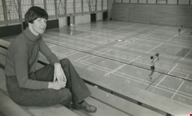
Barbara Robertson
https://search.heritageburnaby.ca/link/archivedescription46339
- Repository
- City of Burnaby Archives
- Date
- March 6, 1978
- Collection/Fonds
- Columbian Newspaper collection
- Description Level
- Item
- Physical Description
- 1 photograph : b&w ; 14.5 x 24 cm
- Scope and Content
- Photograph of the Women's Athletic Coordinator at Simon Fraser University, Barbara Robertson, sitting on the bleachers in the Simon Fraser University gymnasium.
- Repository
- City of Burnaby Archives
- Date
- March 6, 1978
- Collection/Fonds
- Columbian Newspaper collection
- Physical Description
- 1 photograph : b&w ; 14.5 x 24 cm
- Description Level
- Item
- Record No.
- 480-1227
- Access Restriction
- No restrictions
- Reproduction Restriction
- No restrictions
- Accession Number
- 2003-02
- Scope and Content
- Photograph of the Women's Athletic Coordinator at Simon Fraser University, Barbara Robertson, sitting on the bleachers in the Simon Fraser University gymnasium.
- Subjects
- Occupations - Teachers
- Persons - Athletes
- Media Type
- Photograph
- Photographer
- Hodge, Craig
- Notes
- Title based on contents of photograph
- Geographic Access
- University Drive
- Street Address
- 8888 University Drive
- Planning Study Area
- Burnaby Mountain Area
Images

![Barnet, B.C. from the Hill, [1907] thumbnail](/media/hpo/_Data/_Archives_Images/_Unrestricted/371/411-004.jpg?width=280)
Barnet, B.C. from the Hill
https://search.heritageburnaby.ca/link/archivedescription38345
- Repository
- City of Burnaby Archives
- Date
- [1907]
- Collection/Fonds
- Burnaby Historical Society fonds
- Description Level
- Item
- Physical Description
- 1 photograph : sepia postcard ; 8 x 13 cm
- Scope and Content
- Photograph of the village of Barnet at the mill. The caption stamped at the top of the card reads: "Barnet, B.C. from the Hill." The Barnet Mill was called the North Pacific Lumber Company from 1889 to 1914.
- Repository
- City of Burnaby Archives
- Date
- [1907]
- Collection/Fonds
- Burnaby Historical Society fonds
- Subseries
- Charles Lee subseries
- Physical Description
- 1 photograph : sepia postcard ; 8 x 13 cm
- Description Level
- Item
- Record No.
- 411-004
- Access Restriction
- No restrictions
- Reproduction Restriction
- No known restrictions
- Accession Number
- BHS2000-13
- Scope and Content
- Photograph of the village of Barnet at the mill. The caption stamped at the top of the card reads: "Barnet, B.C. from the Hill." The Barnet Mill was called the North Pacific Lumber Company from 1889 to 1914.
- Subjects
- Documentary Artifacts - Postcards
- Buildings - Industrial - Mills
- Geographic Features - Inlets
- Industries - Forestry
- Industries - Logging/lumber
- Names
- Barnet Mill
- Media Type
- Photograph
- Photographer
- Timms Photographic Co.
- Notes
- Title taken from caption
- Geographic Access
- Barnet Village
- Texaco Drive
- Street Address
- 8059 Texaco Drive
- Historic Neighbourhood
- Barnet (Historic Neighbourhood)
- Planning Study Area
- Burnaby Mountain Area
Images
![Barnet, B.C. from the Hill, [1907] thumbnail](/media/hpo/_Data/_Archives_Images/_Unrestricted/371/411-004.jpg)

Barnet Beach
https://search.heritageburnaby.ca/link/archivedescription93650
- Repository
- City of Burnaby Archives
- Date
- November 20, 1977
- Collection/Fonds
- Burnaby Public Library Contemporary Visual Archive Project
- Description Level
- Item
- Physical Description
- 1 photograph : b&w ; 12.5 x 17.5 cm
- Scope and Content
- Photograph of Burrard Inlet, taken facing west from Barnet Beach. Capitol Hill and the Second Narrows Bridge are visible in the distance.
- Repository
- City of Burnaby Archives
- Date
- November 20, 1977
- Collection/Fonds
- Burnaby Public Library Contemporary Visual Archive Project
- Physical Description
- 1 photograph : b&w ; 12.5 x 17.5 cm
- Description Level
- Item
- Record No.
- 556-607
- Access Restriction
- No restrictions
- Reproduction Restriction
- Reproduce for fair dealing purposes only
- Accession Number
- 2017-57
- Scope and Content
- Photograph of Burrard Inlet, taken facing west from Barnet Beach. Capitol Hill and the Second Narrows Bridge are visible in the distance.
- Media Type
- Photograph
- Photographer
- Chapman, Fred
- Notes
- Title taken from project information form
- Accompanied by a project information form and 1 photograph (b&w negative ; 9.5 x 12.5 cm)
- BPL no. 57
- Geographic Access
- Barnet Marine Park
- Historic Neighbourhood
- Barnet (Historic Neighbourhood)
- Planning Study Area
- Burnaby Mountain Area
Images

![Barnet Mill being rebuilt, [1909] (date of original), copied [1998] thumbnail](/media/hpo/_Data/_Archives_Images/_Unrestricted/316/363-002.jpg?width=280)
Barnet Mill being rebuilt
https://search.heritageburnaby.ca/link/archivedescription37363
- Repository
- City of Burnaby Archives
- Date
- [1909] (date of original), copied [1998]
- Collection/Fonds
- Burnaby Historical Society fonds
- Description Level
- Item
- Physical Description
- 1 photograph : b&w ; 10 x 15 cm print
- Scope and Content
- Photograph of lumber piled up and the skeleton of a building being framed during the rebuilding of the Barnet Mill after the fire of 1909. The Barnet Mill was called the North Pacific Lumber Company from 1889 to 1914.
- Repository
- City of Burnaby Archives
- Date
- [1909] (date of original), copied [1998]
- Collection/Fonds
- Burnaby Historical Society fonds
- Subseries
- Jim Wolf subseries
- Physical Description
- 1 photograph : b&w ; 10 x 15 cm print
- Description Level
- Item
- Record No.
- 363-002
- Access Restriction
- No restrictions
- Reproduction Restriction
- No known restrictions
- Accession Number
- BHS1998-13
- Scope and Content
- Photograph of lumber piled up and the skeleton of a building being framed during the rebuilding of the Barnet Mill after the fire of 1909. The Barnet Mill was called the North Pacific Lumber Company from 1889 to 1914.
- Names
- Barnet Mill
- Media Type
- Photograph
- Notes
- Title based on contents of photograph
- Geographic Access
- Barnet Village
- Texaco Drive
- Street Address
- 8059 Texaco Drive
- Historic Neighbourhood
- Barnet (Historic Neighbourhood)
- Planning Study Area
- Burnaby Mountain Area
Images
![Barnet Mill being rebuilt, [1909] (date of original), copied [1998] thumbnail](/media/hpo/_Data/_Archives_Images/_Unrestricted/316/363-002.jpg)
Barnet Neighbourhood
https://search.heritageburnaby.ca/link/landmark716
- Repository
- Burnaby Heritage Planning
- Associated Dates
- 1889-1904
- Heritage Value
- The North Pacific Lumber Company in Barnet was one of Burnaby's first industrial developments and one of the largest in the British Empire. Partners James MacLaren and Frank Ross built the mill in 1889 (activated in 1899) as a requirement for obtaining 84,000 acres of timber rights in northern BC. Due to the mill's isolation, the firm built homes for its employees with families and bunkhouses for the bachelors which separated Caucasian workers from Chinese and Sikh workers. Barnet became a distinct company town with its own general store, school, post office, community hall and telephone exchange.
- Historic Neighbourhood
- Barnet (Historic Neighbourhood)
- Planning Study Area
- Burnaby Mountain Area
Images

Barnet Neighbourhood
https://search.heritageburnaby.ca/link/landmark747
- Repository
- Burnaby Heritage Planning
- Associated Dates
- 1905-1924
- Heritage Value
- The original Barnet mill burned down in 1909 after a dramatic explosion in the boiler house. The company rebuilt a new plant, considered a model of mill construction. The company's timber was towed down the Pacific in huge rafts containing about 400,000 to 500,000 board feet. Mill capacity during a 10-hour day was 150,000 board feet with an amazing annual output of 50 million feet.
- Historic Neighbourhood
- Barnet (Historic Neighbourhood)
- Planning Study Area
- Burnaby Mountain Area
Images


Barnet Rifle Club
https://search.heritageburnaby.ca/link/archivedescription79712
- Repository
- City of Burnaby Archives
- Date
- September 12, 1976
- Collection/Fonds
- Burnaby Public Library Contemporary Visual Archive Project
- Description Level
- Item
- Physical Description
- 1 photograph : b&w ; 11 x 16 cm mounted on cardboard
- Scope and Content
- Photograph shows the sign at the entrance to the Barnet Rifle Club and the Rifle Range at 8550 Barnet Road.
- Repository
- City of Burnaby Archives
- Date
- September 12, 1976
- Collection/Fonds
- Burnaby Public Library Contemporary Visual Archive Project
- Physical Description
- 1 photograph : b&w ; 11 x 16 cm mounted on cardboard
- Description Level
- Item
- Record No.
- 556-396
- Access Restriction
- No restrictions
- Reproduction Restriction
- Reproduce for fair dealing purposes only
- Accession Number
- 2013-13
- Scope and Content
- Photograph shows the sign at the entrance to the Barnet Rifle Club and the Rifle Range at 8550 Barnet Road.
- Names
- Barnet Rifle Club
- Media Type
- Photograph
- Notes
- Scope note taken directly from BPL photograph description.
- 1 b&w copy negative : 10 x 12.5 cm accompanying
- Photographers identified by surnames only: Carr and Vardeman
- Geographic Access
- Barnet Road
- Street Address
- 8550 Barnet Road
- Historic Neighbourhood
- Barnet (Historic Neighbourhood)
- Planning Study Area
- Burnaby Mountain Area
Images


Barnet Rifle Club
https://search.heritageburnaby.ca/link/archivedescription79713
- Repository
- City of Burnaby Archives
- Date
- September, 1976
- Collection/Fonds
- Burnaby Public Library Contemporary Visual Archive Project
- Description Level
- Item
- Physical Description
- 1 photograph : b&w ; 11 x 16 cm mounted on cardboard
- Scope and Content
- Photograph shows a man ascending the steps of the Barnet Rifle Club Clubhouse.
- Repository
- City of Burnaby Archives
- Date
- September, 1976
- Collection/Fonds
- Burnaby Public Library Contemporary Visual Archive Project
- Physical Description
- 1 photograph : b&w ; 11 x 16 cm mounted on cardboard
- Description Level
- Item
- Record No.
- 556-397
- Access Restriction
- No restrictions
- Reproduction Restriction
- Reproduce for fair dealing purposes only
- Accession Number
- 2013-13
- Scope and Content
- Photograph shows a man ascending the steps of the Barnet Rifle Club Clubhouse.
- Names
- Barnet Rifle Club
- Media Type
- Photograph
- Notes
- Scope note taken directly from BPL photograph description.
- 1 b&w copy negative : 10 x 12.5 cm accompanying
- Photographers identified by surnames only: Carr and Vardeman
- Geographic Access
- Barnet Road
- Street Address
- 8550 Barnet Road
- Historic Neighbourhood
- Barnet (Historic Neighbourhood)
- Planning Study Area
- Burnaby Mountain Area
Images


Barnet Rifle Club
https://search.heritageburnaby.ca/link/archivedescription79714
- Repository
- City of Burnaby Archives
- Date
- September 12, 1976
- Collection/Fonds
- Burnaby Public Library Contemporary Visual Archive Project
- Description Level
- Item
- Physical Description
- 1 photograph : b&w ; 11 x 16 cm mounted on cardboard
- Scope and Content
- Photograph shows the covered firing line at the Barnet Rifle Range.
- Repository
- City of Burnaby Archives
- Date
- September 12, 1976
- Collection/Fonds
- Burnaby Public Library Contemporary Visual Archive Project
- Physical Description
- 1 photograph : b&w ; 11 x 16 cm mounted on cardboard
- Description Level
- Item
- Record No.
- 556-398
- Access Restriction
- No restrictions
- Reproduction Restriction
- Reproduce for fair dealing purposes only
- Accession Number
- 2013-13
- Scope and Content
- Photograph shows the covered firing line at the Barnet Rifle Range.
- Names
- Barnet Rifle Club
- Media Type
- Photograph
- Notes
- Scope note taken directly from BPL photograph description.
- 1 b&w copy negative : 10 x 12.5 cm accompanying
- Photographers identified by surnames only: Carr and Vardeman
- Geographic Access
- Barnet Road
- Street Address
- 8550 Barnet Road
- Historic Neighbourhood
- Barnet (Historic Neighbourhood)
- Planning Study Area
- Burnaby Mountain Area
Images


Barnet Rifle Club
https://search.heritageburnaby.ca/link/archivedescription79716
- Repository
- City of Burnaby Archives
- Date
- September 12, 1976
- Collection/Fonds
- Burnaby Public Library Contemporary Visual Archive Project
- Description Level
- Item
- Physical Description
- 1 photograph : b&w ; 11 x 16 cm mounted on cardboard
- Scope and Content
- Photograph shows two men shooting at targets on the Barnet Rifle Range.
- Repository
- City of Burnaby Archives
- Date
- September 12, 1976
- Collection/Fonds
- Burnaby Public Library Contemporary Visual Archive Project
- Physical Description
- 1 photograph : b&w ; 11 x 16 cm mounted on cardboard
- Description Level
- Item
- Record No.
- 556-399
- Access Restriction
- No restrictions
- Reproduction Restriction
- Reproduce for fair dealing purposes only
- Accession Number
- 2013-13
- Scope and Content
- Photograph shows two men shooting at targets on the Barnet Rifle Range.
- Names
- Barnet Rifle Club
- Media Type
- Photograph
- Notes
- Scope note taken directly from BPL photograph description.
- 1 b&w copy negative : 10 x 12.5 cm accompanying
- Photographers identified by surnames only: Carr and Vardeman
- Geographic Access
- Barnet Road
- Street Address
- 8550 Barnet Road
- Historic Neighbourhood
- Barnet (Historic Neighbourhood)
- Planning Study Area
- Burnaby Mountain Area
Images


Burnaby Fish and Game Club Range
https://search.heritageburnaby.ca/link/archivedescription79719
- Repository
- City of Burnaby Archives
- Date
- September 12, 1976
- Collection/Fonds
- Burnaby Public Library Contemporary Visual Archive Project
- Description Level
- Item
- Physical Description
- 1 photograph : b&w ; 11 x 16 cm mounted on cardboard
- Scope and Content
- Photograph shows cars parked outside the Burnaby Fish and Game Club Rifle Range at 8242 Barnet Road.
- Repository
- City of Burnaby Archives
- Date
- September 12, 1976
- Collection/Fonds
- Burnaby Public Library Contemporary Visual Archive Project
- Physical Description
- 1 photograph : b&w ; 11 x 16 cm mounted on cardboard
- Description Level
- Item
- Record No.
- 556-400
- Access Restriction
- No restrictions
- Reproduction Restriction
- Reproduce for fair dealing purposes only
- Accession Number
- 2013-13
- Scope and Content
- Photograph shows cars parked outside the Burnaby Fish and Game Club Rifle Range at 8242 Barnet Road.
- Media Type
- Photograph
- Notes
- Scope note taken directly from BPL photograph description.
- 1 b&w copy negative : 10 x 12.5 cm accompanying
- Photographers identified by surnames only: Carr and Vardeman
- Geographic Access
- Barnet Road
- Street Address
- 8242 Barnet Road
- Historic Neighbourhood
- Barnet (Historic Neighbourhood)
- Planning Study Area
- Burnaby Mountain Area
Images


Burnaby Mountain Neighbourhood
https://search.heritageburnaby.ca/link/landmark792
- Repository
- Burnaby Heritage Planning
- Associated Dates
- 1955-2008
- Heritage Value
- Burnaby Mountain had been dedicated as park in 1942, however the original park boundaries were reconsidered in 1952 with the development of the Trans Mountain Pipeline. Although the boundaries were adjusted to accommodate this project, significant conservation and park lands were left untouched. When, in 1962, the government of British Columbia determined the need for additional post-secondary facilities, Burnaby Mountain was chosen as the site for the new Simon Fraser University which opened in 1965. As early as 1964, the idea of establishing a townsite around the university had been discussed by Burnaby, but it was not until the mid-1990s that the idea came to fruition and by the early 2000s, a new housing development know as the UniverCity took shape on the mountain adjacent to the university.
- Historic Neighbourhood
- Barnet (Historic Neighbourhood)
- Planning Study Area
- Burnaby Mountain Area
Images


Burnaby Mountain Park
https://search.heritageburnaby.ca/link/archivedescription37403
- Repository
- City of Burnaby Archives
- Date
- 1970
- Collection/Fonds
- Burnaby Historical Society fonds
- Description Level
- Item
- Physical Description
- 1 photograph : col. postcard ; 9 x 14 cm
- Scope and Content
- Photograph of Burnaby Mountain Park looking west towards Vancouver. The caption on the back of the postcard reads: "This view was taken from Burnaby Mountain Park, which is adjacent to Simon Fraser University. Some of the most spectacular views can be seen from this high elevation."
- Repository
- City of Burnaby Archives
- Date
- 1970
- Collection/Fonds
- Burnaby Historical Society fonds
- Subseries
- Robert Prittie subseries
- Physical Description
- 1 photograph : col. postcard ; 9 x 14 cm
- Description Level
- Item
- Record No.
- 369-002
- Access Restriction
- No restrictions
- Reproduction Restriction
- Reproduce for fair dealing purposes only
- Accession Number
- BHS1999-01
- Scope and Content
- Photograph of Burnaby Mountain Park looking west towards Vancouver. The caption on the back of the postcard reads: "This view was taken from Burnaby Mountain Park, which is adjacent to Simon Fraser University. Some of the most spectacular views can be seen from this high elevation."
- Media Type
- Photograph
- Photographer
- Weinhaupl, George
- Notes
- Title based on contents of photograph
- Geographic Access
- Burnaby Mountain Conservation Area
- Centennial Way
- Street Address
- 100 Centennial Way
- Planning Study Area
- Burnaby Mountain Area
Images


Burnaby Mountain Park
https://search.heritageburnaby.ca/link/archivedescription93639
- Repository
- City of Burnaby Archives
- Date
- November 19, 1977
- Collection/Fonds
- Burnaby Public Library Contemporary Visual Archive Project
- Description Level
- Item
- Physical Description
- 1 photograph : b&w ; 12.5 x 17.5 cm
- Scope and Content
- Photograph of the hillside on the top of Burnaby Mountain Park, with a person in the foreground looking out to the view. The photograph is taken facing northwest and shows the view over the the Burrard Inlet. Capitol Hill, the North Shore Mountains, and downtown Vancouver are visible in the distanc…
- Repository
- City of Burnaby Archives
- Date
- November 19, 1977
- Collection/Fonds
- Burnaby Public Library Contemporary Visual Archive Project
- Physical Description
- 1 photograph : b&w ; 12.5 x 17.5 cm
- Description Level
- Item
- Record No.
- 556-596
- Access Restriction
- No restrictions
- Reproduction Restriction
- Reproduce for fair dealing purposes only
- Accession Number
- 2017-57
- Scope and Content
- Photograph of the hillside on the top of Burnaby Mountain Park, with a person in the foreground looking out to the view. The photograph is taken facing northwest and shows the view over the the Burrard Inlet. Capitol Hill, the North Shore Mountains, and downtown Vancouver are visible in the distance.
- Names
- Burnaby Mountain Park
- Media Type
- Photograph
- Photographer
- van Mannen, Mark
- Notes
- Title taken from project information form
- Accompanied by a project information form and 1 photograph (b&w negative ; 9.5 x 12.5 cm)
- BPL no. 45
- Geographic Access
- Burnaby Mountain Conservation Area
- Planning Study Area
- Burnaby Mountain Area
Images


Burnaby Mountain Park
https://search.heritageburnaby.ca/link/archivedescription93640
- Repository
- City of Burnaby Archives
- Date
- November 19, 1977
- Collection/Fonds
- Burnaby Public Library Contemporary Visual Archive Project
- Description Level
- Item
- Physical Description
- 1 photograph : b&w ; 12.5 x 17.5 cm
- Scope and Content
- Photograph of the top of Burnaby Mountain Park and the view of Vancouver from the hillside, with a man standing in the foreground. The photograph is taken facing west of southwest. Capitol Hill, the Burrard Inlet, the North Shore Mountains, Vancouver, and Stanley Park are visible in the distance.
- Repository
- City of Burnaby Archives
- Date
- November 19, 1977
- Collection/Fonds
- Burnaby Public Library Contemporary Visual Archive Project
- Physical Description
- 1 photograph : b&w ; 12.5 x 17.5 cm
- Description Level
- Item
- Record No.
- 556-597
- Access Restriction
- No restrictions
- Reproduction Restriction
- Reproduce for fair dealing purposes only
- Accession Number
- 2017-57
- Scope and Content
- Photograph of the top of Burnaby Mountain Park and the view of Vancouver from the hillside, with a man standing in the foreground. The photograph is taken facing west of southwest. Capitol Hill, the Burrard Inlet, the North Shore Mountains, Vancouver, and Stanley Park are visible in the distance.
- Names
- Burnaby Mountain Park
- Media Type
- Photograph
- Photographer
- McGillivray, Don
- Notes
- Title taken from project information form
- Accompanied by a project information form and 1 photograph (b&w negative ; 9.5 x 12.5 cm)
- BPL no. 46
- Geographic Access
- Burnaby Mountain Conservation Area
- Planning Study Area
- Burnaby Mountain Area
Images


Burnaby Mountain Park
https://search.heritageburnaby.ca/link/archivedescription93645
- Repository
- City of Burnaby Archives
- Date
- November 19, 1977
- Collection/Fonds
- Burnaby Public Library Contemporary Visual Archive Project
- Description Level
- Item
- Physical Description
- 1 photograph : b&w ; 12.5 x 17.5 cm
- Scope and Content
- Photograph of the view from Burnaby Mountain of the Burrard Inlet, the oil refinery, and the mountains. The photograph is taken from Burnaby Mountain Park, facing north.
- Repository
- City of Burnaby Archives
- Date
- November 19, 1977
- Collection/Fonds
- Burnaby Public Library Contemporary Visual Archive Project
- Physical Description
- 1 photograph : b&w ; 12.5 x 17.5 cm
- Description Level
- Item
- Record No.
- 556-602
- Access Restriction
- No restrictions
- Reproduction Restriction
- Reproduce for fair dealing purposes only
- Accession Number
- 2017-57
- Scope and Content
- Photograph of the view from Burnaby Mountain of the Burrard Inlet, the oil refinery, and the mountains. The photograph is taken from Burnaby Mountain Park, facing north.
- Subjects
- Geographic Features - Inlets
- Geographic Features - Parks
- Geographic Features - Mountains
- Buildings - Industrial - Refineries
- Names
- Burnaby Mountain Park
- Media Type
- Photograph
- Photographer
- van Mannen, Mark
- Notes
- Title taken from project information form
- Accompanied by a project information form and 1 photograph (b&w negative ; 9.5 x 12.5 cm)
- BPL no. 52
- Geographic Access
- Burnaby Mountain Conservation Area
- Burrard Inlet
- Planning Study Area
- Burnaby Mountain Area
Images


Burnaby Mountain Park and Centennial Pavilion
https://search.heritageburnaby.ca/link/archivedescription37408
- Repository
- City of Burnaby Archives
- Date
- 1970
- Collection/Fonds
- Burnaby Historical Society fonds
- Description Level
- Item
- Physical Description
- 1 photograph : col. postcard ; 9 x 14 cm
- Scope and Content
- Photographic postcard of the Burnaby Mountain Park sign a Centennial Pavilion. The caption on the back of the postcard reads: "The Centennial Pavilion was built in 1958 during British Columbia's Centenary. It is situated on Burnaby Mountain at an elevation of 1000 feet. Numerous footpaths througho…
- Repository
- City of Burnaby Archives
- Date
- 1970
- Collection/Fonds
- Burnaby Historical Society fonds
- Subseries
- Robert Prittie subseries
- Physical Description
- 1 photograph : col. postcard ; 9 x 14 cm
- Description Level
- Item
- Record No.
- 369-007
- Access Restriction
- No restrictions
- Reproduction Restriction
- Reproduce for fair dealing purposes only
- Accession Number
- BHS1999-01
- Scope and Content
- Photographic postcard of the Burnaby Mountain Park sign a Centennial Pavilion. The caption on the back of the postcard reads: "The Centennial Pavilion was built in 1958 during British Columbia's Centenary. It is situated on Burnaby Mountain at an elevation of 1000 feet. Numerous footpaths throughout the beautifully landscaped grounds lead to interesting view points which provide magnificent scenery of Burrard Inlet, Coast Range Mountains, City of Vancouver, and other surrounding Municipalities."
- Subjects
- Symbols - Flags
- Documentary Artifacts - Postcards
- Buildings - Recreational
- Advertising Medium - Signs and Signboards
- Media Type
- Photograph
- Photographer
- George Allen Aerial Photos Limited
- Notes
- Title based on caption
- Geographic Access
- Burnaby Mountain Conservation Area
- Centennial Way
- Street Address
- 100 Centennial Way
- Planning Study Area
- Burnaby Mountain Area
Images
