Narrow Results By
Subject
- Academic Disciplines
- Accidents 10
- Accidents - Automobile Accidents 26
- Accidents - Train Accidents 8
- Adornment - Jewelry 3
- Adornment - Lapel Pins 1
- Advertising Medium 10
- Advertising Medium - Signs and Signboards
- Aerial Photographs 127
- Agricultural Tools and Equipment 16
- Agricultural Tools and Equipment - Cultivators 1
- Agricultural Tools and Equipment - Gardening Equipment 10
Person / Organization
- A & Aero Trading Salvage 1
- Admiral Hotel 2
- A. MacKenzie and Company Jubilee Store 3
- Anthony, Bill 1
- Astor Hotel 3
- Baker, Ronald J. "Ron" 3
- Blue Mountain Flower and Garden Shop 1
- Bonsor Recreation Complex 1
- Bossort, Kathy 3
- Bowker, A.D. 1
- British Columbia Hydro and Power Authority 2
- Burnaby Art Gallery 1
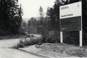
Quesnel Greene Construction
https://search.heritageburnaby.ca/link/archivedescription79014
- Repository
- City of Burnaby Archives
- Date
- October 23, 1976
- Collection/Fonds
- Burnaby Public Library Contemporary Visual Archive Project
- Description Level
- Item
- Physical Description
- 1 photograph : b&w ; 11 x 16 cm mounted on cardboard
- Scope and Content
- Photograph shows Quesnel Greene construction sign located at the corner of Aquarius Drive and Centaurus Circle. The Quesnel Green Co-operative Housing project was designed by Neinhaker/Irwin Associates and was built by Dunhill Development Corporation Ltd. It was owned by the Government of British…
- Repository
- City of Burnaby Archives
- Date
- October 23, 1976
- Collection/Fonds
- Burnaby Public Library Contemporary Visual Archive Project
- Physical Description
- 1 photograph : b&w ; 11 x 16 cm mounted on cardboard
- Description Level
- Item
- Record No.
- 556-091
- Access Restriction
- No restrictions
- Reproduction Restriction
- Reproduce for fair dealing purposes only
- Accession Number
- 2013-13
- Scope and Content
- Photograph shows Quesnel Greene construction sign located at the corner of Aquarius Drive and Centaurus Circle. The Quesnel Green Co-operative Housing project was designed by Neinhaker/Irwin Associates and was built by Dunhill Development Corporation Ltd. It was owned by the Government of British Columbia.
- Media Type
- Photograph
- Photographer
- Campbell, Peg
- Notes
- Scope note taken directly from BPL photograph description.
- 1 b&w copy negative : 10 x 12.5 cm accompanying
- Geographic Access
- Centaurus Circle
- Aquarius Drive
- Historic Neighbourhood
- Burquitlam (Historic Neighbourhood)
- Planning Study Area
- Lyndhurst Area
Images
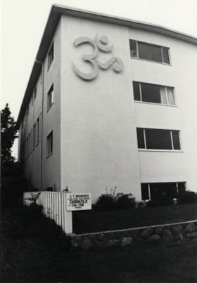
Apartment at Albert and Ingleton
https://search.heritageburnaby.ca/link/archivedescription79031
- Repository
- City of Burnaby Archives
- Date
- September 12, 1976
- Collection/Fonds
- Burnaby Public Library Contemporary Visual Archive Project
- Description Level
- Item
- Physical Description
- 1 photograph : b&w ; 11 x 16 cm mounted on cardboard
- Scope and Content
- Photograph shows a sign on an apartment building on Albert Street near Ingleton Avenue.
- Repository
- City of Burnaby Archives
- Date
- September 12, 1976
- Collection/Fonds
- Burnaby Public Library Contemporary Visual Archive Project
- Physical Description
- 1 photograph : b&w ; 11 x 16 cm mounted on cardboard
- Description Level
- Item
- Record No.
- 556-102
- Access Restriction
- No restrictions
- Reproduction Restriction
- Reproduce for fair dealing purposes only
- Accession Number
- 2013-13
- Scope and Content
- Photograph shows a sign on an apartment building on Albert Street near Ingleton Avenue.
- Media Type
- Photograph
- Notes
- Scope note taken directly from BPL photograph description.
- 1 b&w copy negative : 10 x 12.5 cm accompanying
- Photographers identified by surnames only: Carr and Vardeman
- Geographic Access
- Albert Street
- Ingleton Avenue
- Historic Neighbourhood
- Vancouver Heights (Historic Neighbourhood)
- Planning Study Area
- Burnaby Heights Area
Images
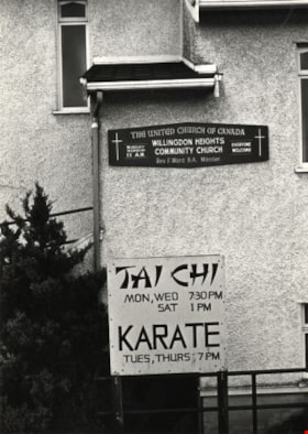
Signs at the Willingdon Heights Community Church
https://search.heritageburnaby.ca/link/archivedescription79050
- Repository
- City of Burnaby Archives
- Date
- October, 1976
- Collection/Fonds
- Burnaby Public Library Contemporary Visual Archive Project
- Description Level
- Item
- Physical Description
- 1 photograph : b&w ; 11 x 16 cm mounted on cardboard
- Scope and Content
- Photograph shows signs at the Willingdon Heights Community Church, advertising activities at the Church.
- Repository
- City of Burnaby Archives
- Date
- October, 1976
- Collection/Fonds
- Burnaby Public Library Contemporary Visual Archive Project
- Physical Description
- 1 photograph : b&w ; 11 x 16 cm mounted on cardboard
- Description Level
- Item
- Record No.
- 556-117
- Access Restriction
- No restrictions
- Reproduction Restriction
- Reproduce for fair dealing purposes only
- Accession Number
- 2013-13
- Scope and Content
- Photograph shows signs at the Willingdon Heights Community Church, advertising activities at the Church.
- Media Type
- Photograph
- Photographer
- Cook, Alan
- Notes
- Scope note taken directly from BPL photograph description.
- 1 b&w copy negative : 10 x 12.5 cm accompanying
- Geographic Access
- Parker Street
- Street Address
- 4304 Parker Street
- Historic Neighbourhood
- Vancouver Heights (Historic Neighbourhood)
- Planning Study Area
- Willingdon Heights Area
Images
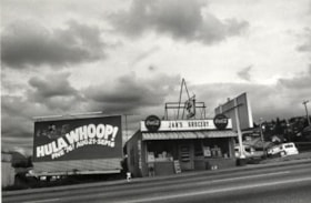
Advertising adjacent Jan's Grocery Store
https://search.heritageburnaby.ca/link/archivedescription79082
- Repository
- City of Burnaby Archives
- Date
- October, 1976
- Collection/Fonds
- Burnaby Public Library Contemporary Visual Archive Project
- Description Level
- Item
- Physical Description
- 1 photograph : b&w ; 11 x 16 cm mounted on cardboard
- Scope and Content
- Photograph shows large billboard advertising the PNE, beside Jan's Grocery store located at 4759 Hastings Street.
- Repository
- City of Burnaby Archives
- Date
- October, 1976
- Collection/Fonds
- Burnaby Public Library Contemporary Visual Archive Project
- Physical Description
- 1 photograph : b&w ; 11 x 16 cm mounted on cardboard
- Description Level
- Item
- Record No.
- 556-141
- Access Restriction
- No restrictions
- Reproduction Restriction
- Reproduce for fair dealing purposes only
- Accession Number
- 2013-13
- Scope and Content
- Photograph shows large billboard advertising the PNE, beside Jan's Grocery store located at 4759 Hastings Street.
- Media Type
- Photograph
- Photographer
- Cook, Alan
- Notes
- Scope note taken directly from BPL photograph description.
- 1 b&w copy negative : 10 x 12.5 cm accompanying
- Geographic Access
- Hastings Street
- Street Address
- 4759 Hastings Street
- Historic Neighbourhood
- Capitol Hill (Historic Neighbourhood)
- Planning Study Area
- Capitol Hill Area
Images
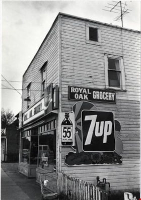
Royal Oak Grocery
https://search.heritageburnaby.ca/link/archivedescription79092
- Repository
- City of Burnaby Archives
- Date
- September 13, 1976
- Collection/Fonds
- Burnaby Public Library Contemporary Visual Archive Project
- Description Level
- Item
- Physical Description
- 1 photograph : b&w ; 11 x 16 cm mounted on cardboard
- Scope and Content
- Photograph shows Royal Oak Grocery located at 6537 Royal Oak Avenue. The store was built in approximately 1946 and has living quarters above.
- Repository
- City of Burnaby Archives
- Date
- September 13, 1976
- Collection/Fonds
- Burnaby Public Library Contemporary Visual Archive Project
- Physical Description
- 1 photograph : b&w ; 11 x 16 cm mounted on cardboard
- Description Level
- Item
- Record No.
- 556-146
- Access Restriction
- No restrictions
- Reproduction Restriction
- Reproduce for fair dealing purposes only
- Accession Number
- 2013-13
- Scope and Content
- Photograph shows Royal Oak Grocery located at 6537 Royal Oak Avenue. The store was built in approximately 1946 and has living quarters above.
- Names
- Royal Oak Grocery
- Media Type
- Photograph
- Photographer
- McCarron, John
- Notes
- Scope note taken directly from BPL photograph description.
- 1 b&w copy negative : 10 x 12.5 cm accompanying
- Geographic Access
- Royal Oak Avenue
- Street Address
- 6537 Royal Oak Avenue
- Historic Neighbourhood
- Central Park (Historic Neighbourhood)
- Planning Study Area
- Marlborough Area
Images
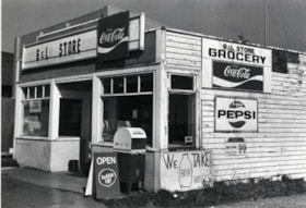
G & L Store
https://search.heritageburnaby.ca/link/archivedescription79113
- Repository
- City of Burnaby Archives
- Date
- September 20, 1976
- Collection/Fonds
- Burnaby Public Library Contemporary Visual Archive Project
- Description Level
- Item
- Physical Description
- 1 photograph : b&w ; 11 x 16 cm mounted on cardboard
- Scope and Content
- Photograph shows numerous signs on the wall of the G & L Store built around 1945 on MacPherson Avenue near Beresford Street.
- Repository
- City of Burnaby Archives
- Date
- September 20, 1976
- Collection/Fonds
- Burnaby Public Library Contemporary Visual Archive Project
- Physical Description
- 1 photograph : b&w ; 11 x 16 cm mounted on cardboard
- Description Level
- Item
- Record No.
- 556-161
- Access Restriction
- No restrictions
- Reproduction Restriction
- Reproduce for fair dealing purposes only
- Accession Number
- 2013-13
- Scope and Content
- Photograph shows numerous signs on the wall of the G & L Store built around 1945 on MacPherson Avenue near Beresford Street.
- Media Type
- Photograph
- Photographer
- McCarron, John
- Notes
- Scope note taken directly from BPL photograph description.
- 1 b&w copy negative : 10 x 12.5 cm accompanying
- Geographic Access
- MacPherson Avenue
- Beresford Street
- Planning Study Area
- Windsor Area
Images
Advertising Signs
https://search.heritageburnaby.ca/link/archivedescription79154
- Repository
- City of Burnaby Archives
- Date
- November 1, 1976
- Collection/Fonds
- Burnaby Public Library Contemporary Visual Archive Project
- Description Level
- Item
- Physical Description
- 1 photograph : b&w ; 11 x 16 cm mounted on cardboard
- Scope and Content
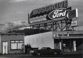
- Photograph shows signs advertising Musgrove Ford Ltd. and Burnaby Cleaners on top of the building which housed Burnaby Cleaners at 4429 Hastings Street.
- Repository
- City of Burnaby Archives
- Date
- November 1, 1976
- Collection/Fonds
- Burnaby Public Library Contemporary Visual Archive Project
- Physical Description
- 1 photograph : b&w ; 11 x 16 cm mounted on cardboard
- Description Level
- Item
- Record No.
- 556-178
- Access Restriction
- No restrictions
- Reproduction Restriction
- Reproduce for fair dealing purposes only
- Accession Number
- 2013-13
- Scope and Content
- Photograph shows signs advertising Musgrove Ford Ltd. and Burnaby Cleaners on top of the building which housed Burnaby Cleaners at 4429 Hastings Street.
- Names
- Burnaby Cleaners
- Media Type
- Photograph
- Notes
- Scope note taken directly from BPL photograph description.
- 1 b&w copy negative : 10 x 12.5 cm accompanying
- Photographers identified by surnames only: Carr and Vardeman
- Geographic Access
- Hastings Street
- Street Address
- 4429 Hastings Street
- Historic Neighbourhood
- Vancouver Heights (Historic Neighbourhood)
- Planning Study Area
- Burnaby Heights Area
Images
Billboards at Hastings and Boundary
https://search.heritageburnaby.ca/link/archivedescription79163
- Repository
- City of Burnaby Archives
- Date
- November 1, 1976
- Collection/Fonds
- Burnaby Public Library Contemporary Visual Archive Project
- Description Level
- Item
- Physical Description
- 1 photograph : b&w ; 11 x 16 cm mounted on cardboard
- Scope and Content
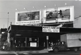
- Photograph shows men working on billboards above Moffat's Furniture at the corner of Hastings Street and Boundary Road.
- Repository
- City of Burnaby Archives
- Date
- November 1, 1976
- Collection/Fonds
- Burnaby Public Library Contemporary Visual Archive Project
- Physical Description
- 1 photograph : b&w ; 11 x 16 cm mounted on cardboard
- Description Level
- Item
- Record No.
- 556-182
- Access Restriction
- No restrictions
- Reproduction Restriction
- Reproduce for fair dealing purposes only
- Accession Number
- 2013-13
- Scope and Content
- Photograph shows men working on billboards above Moffat's Furniture at the corner of Hastings Street and Boundary Road.
- Names
- Moffat's Furniture
- Media Type
- Photograph
- Notes
- Scope note taken directly from BPL photograph description.
- 1 b&w copy negative : 10 x 12.5 cm accompanying
- Photographers identified by surnames only: Carr and Vardeman
- Geographic Access
- Hastings Street
- Boundary Road
- Historic Neighbourhood
- Vancouver Heights (Historic Neighbourhood)
- Planning Study Area
- Willingdon Heights Area
Images
A & Aero Trading Salvage
https://search.heritageburnaby.ca/link/archivedescription79166
- Repository
- City of Burnaby Archives
- Date
- October 16, 1976
- Collection/Fonds
- Burnaby Public Library Contemporary Visual Archive Project
- Description Level
- Item
- Physical Description
- 1 photograph : b&w ; 11 x 16 cm mounted on cardboard
- Scope and Content
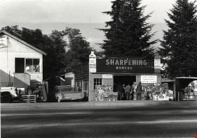
- Photograph shows a large sign advertising lawn mower sharpening over A & Aero Trading Salvage at 6147 Hastings Street.
- Repository
- City of Burnaby Archives
- Date
- October 16, 1976
- Collection/Fonds
- Burnaby Public Library Contemporary Visual Archive Project
- Physical Description
- 1 photograph : b&w ; 11 x 16 cm mounted on cardboard
- Description Level
- Item
- Record No.
- 556-184
- Access Restriction
- No restrictions
- Reproduction Restriction
- Reproduce for fair dealing purposes only
- Accession Number
- 2013-13
- Scope and Content
- Photograph shows a large sign advertising lawn mower sharpening over A & Aero Trading Salvage at 6147 Hastings Street.
- Names
- A & Aero Trading Salvage
- Media Type
- Photograph
- Notes
- Scope note taken directly from BPL photograph description.
- 1 b&w copy negative : 10 x 12.5 cm accompanying
- Photographers identified by surnames only: Carr and Vardeman
- Geographic Access
- Hastings Street
- Street Address
- 6147 Hastings Street
- Historic Neighbourhood
- Lochdale (Historic Neighbourhood)
- Planning Study Area
- Westridge Area
Images
Kiddies' World
https://search.heritageburnaby.ca/link/archivedescription79170
- Repository
- City of Burnaby Archives
- Date
- September 20, 1976
- Collection/Fonds
- Burnaby Public Library Contemporary Visual Archive Project
- Description Level
- Item
- Physical Description
- 1 photograph : b&w ; 11 x 16 cm mounted on cardboard
- Scope and Content
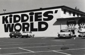
- Photograph shows Kiddies' World Store at 9607 Lougheed Highway.
- Repository
- City of Burnaby Archives
- Date
- September 20, 1976
- Collection/Fonds
- Burnaby Public Library Contemporary Visual Archive Project
- Physical Description
- 1 photograph : b&w ; 11 x 16 cm mounted on cardboard
- Description Level
- Item
- Record No.
- 556-187
- Access Restriction
- No restrictions
- Reproduction Restriction
- Reproduce for fair dealing purposes only
- Accession Number
- 2013-13
- Scope and Content
- Photograph shows Kiddies' World Store at 9607 Lougheed Highway.
- Names
- Kiddies' World
- Media Type
- Photograph
- Photographer
- Campbell, Peg
- Notes
- Scope note taken directly from BPL photograph description.
- 1 b&w copy negative : 10 x 12.5 cm accompanying
- Geographic Access
- Lougheed Highway
- Street Address
- 9607 Lougheed Highway
- Historic Neighbourhood
- Burquitlam (Historic Neighbourhood)
- Planning Study Area
- Cameron Area
Images
McKay Barbers
https://search.heritageburnaby.ca/link/archivedescription79177
- Repository
- City of Burnaby Archives
- Date
- September 15, 1976
- Collection/Fonds
- Burnaby Public Library Contemporary Visual Archive Project
- Description Level
- Item
- Physical Description
- 1 photograph : b&w ; 11 x 16 cm mounted on cardboard
- Scope and Content
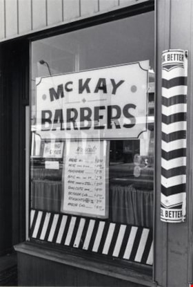
- Photograph shows signs in the window of McKay Barbers advertising prices for haircuts. The shop, on Kingsway near McKay, was built in the 1920s originally as part of the grocery store next door and was a bakery for a time. At the time of the photograph, it had been a barber shop for 42 years.
- Repository
- City of Burnaby Archives
- Date
- September 15, 1976
- Collection/Fonds
- Burnaby Public Library Contemporary Visual Archive Project
- Physical Description
- 1 photograph : b&w ; 11 x 16 cm mounted on cardboard
- Description Level
- Item
- Record No.
- 556-191
- Access Restriction
- No restrictions
- Reproduction Restriction
- Reproduce for fair dealing purposes only
- Accession Number
- 2013-13
- Scope and Content
- Photograph shows signs in the window of McKay Barbers advertising prices for haircuts. The shop, on Kingsway near McKay, was built in the 1920s originally as part of the grocery store next door and was a bakery for a time. At the time of the photograph, it had been a barber shop for 42 years.
- Names
- McKay Barber Shop
- Media Type
- Photograph
- Photographer
- McCarron, John
- Notes
- Scope note taken directly from BPL photograph description.
- 1 b&w copy negative : 10 x 12.5 cm accompanying
- Geographic Access
- McKay Avenue
- Historic Neighbourhood
- Central Park (Historic Neighbourhood)
- Planning Study Area
- Maywood Area
Images
Maywood Barber Shop
https://search.heritageburnaby.ca/link/archivedescription79179
- Repository
- City of Burnaby Archives
- Date
- October, 1976
- Collection/Fonds
- Burnaby Public Library Contemporary Visual Archive Project
- Description Level
- Item
- Physical Description
- 1 photograph : b&w ; 11 x 16 cm mounted on cardboard
- Scope and Content
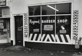
- Photograph shows the Maywood Barber Shop at 4386 Imperial Street. The building was built in the 1930s and the baber shop opened in 1963.
- Repository
- City of Burnaby Archives
- Date
- October, 1976
- Collection/Fonds
- Burnaby Public Library Contemporary Visual Archive Project
- Physical Description
- 1 photograph : b&w ; 11 x 16 cm mounted on cardboard
- Description Level
- Item
- Record No.
- 556-192
- Access Restriction
- No restrictions
- Reproduction Restriction
- Reproduce for fair dealing purposes only
- Accession Number
- 2013-13
- Scope and Content
- Photograph shows the Maywood Barber Shop at 4386 Imperial Street. The building was built in the 1930s and the baber shop opened in 1963.
- Names
- Maywood Barber Shop
- Media Type
- Photograph
- Photographer
- Cook, Alan
- Notes
- Scope note taken directly from BPL photograph description.
- 1 b&w copy negative : 10 x 12.5 cm accompanying
- Geographic Access
- Imperial Street
- Street Address
- 4368 Imperial Street
- Historic Neighbourhood
- Alta-Vista (Historic Neighbourhood)
- Planning Study Area
- Sussex-Nelson Area
Images
Sussex Villa
https://search.heritageburnaby.ca/link/archivedescription98659
- Repository
- City of Burnaby Archives
- Date
- 2022
- Collection/Fonds
- Disappearing Burnaby collection
- Description Level
- Item
- Physical Description
- 1 photograph (jpeg) : col.
- Scope and Content
- Photograph of part of the exterior and front lawn of Sussex Villa, an apartment complex located at 6620-6630 Sussex Avenue, at night. The building was constructed in 1965 and is set to be developed into a high-rise tower by Keltic Canada Development. A light is on inside one of the apartment window…
- Repository
- City of Burnaby Archives
- Date
- 2022
- Collection/Fonds
- Disappearing Burnaby collection
- Physical Description
- 1 photograph (jpeg) : col.
- Description Level
- Item
- Record No.
- 634-006
- Access Restriction
- No restrictions
- Reproduction Restriction
- No restrictions
- Accession Number
- 2022-14
- Scope and Content
- Photograph of part of the exterior and front lawn of Sussex Villa, an apartment complex located at 6620-6630 Sussex Avenue, at night. The building was constructed in 1965 and is set to be developed into a high-rise tower by Keltic Canada Development. A light is on inside one of the apartment windows and a sign for the "Metrotown - Regional Town Centre Notification of Area Plan" stands on the lawn.
- Subjects
- Buildings - Residential - Apartments
- Buildings - Residential
- Advertising Medium - Signs and Signboards
- Planning - City Planning
- Media Type
- Photograph
- Photographer
- Cheung, Nakita
- Notes
- Title taken from the associated blog post
- Associated blog post: https://disappearingburnaby.wordpress.com/2022/01/29/sussex-villa-2/
- Geographic Access
- Sussex Avenue
- Street Address
- 6620 Sussex Avenue
- 6630 Sussex Avenue
- Historic Neighbourhood
- Central Park (Historic Neighbourhood)
- Planning Study Area
- Maywood Area
Images
Sussex Villa with sign
https://search.heritageburnaby.ca/link/archivedescription98660
- Repository
- City of Burnaby Archives
- Date
- 2022
- Collection/Fonds
- Disappearing Burnaby collection
- Description Level
- Item
- Physical Description
- 1 photograph (jpeg) : col.
- Scope and Content
- Photograph of part of the exterior and front lawn of Sussex Villa, an apartment complex located at 6620-6630 Sussex Avenue, at night. The building was constructed in 1965 and is set to be developed into a high-rise tower by Keltic Canada Development. A sign standing on the lawn reads: "Land Loan" a…
- Repository
- City of Burnaby Archives
- Date
- 2022
- Collection/Fonds
- Disappearing Burnaby collection
- Physical Description
- 1 photograph (jpeg) : col.
- Description Level
- Item
- Record No.
- 634-007
- Access Restriction
- No restrictions
- Reproduction Restriction
- No restrictions
- Accession Number
- 2022-14
- Scope and Content
- Photograph of part of the exterior and front lawn of Sussex Villa, an apartment complex located at 6620-6630 Sussex Avenue, at night. The building was constructed in 1965 and is set to be developed into a high-rise tower by Keltic Canada Development. A sign standing on the lawn reads: "Land Loan" and "Domain Funding" with contact information, and a residential tower is visible in the background.
- Subjects
- Buildings - Residential - Apartments
- Buildings - Residential
- Advertising Medium - Signs and Signboards
- Media Type
- Photograph
- Photographer
- Cheung, Nakita
- Notes
- Title taken from the associated blog post
- Associated blog post: https://disappearingburnaby.wordpress.com/2022/01/29/sussex-villa-2/
- Geographic Access
- Sussex Avenue
- Street Address
- 6620 Sussex Avenue
- 6630 Sussex Avenue
- Historic Neighbourhood
- Central Park (Historic Neighbourhood)
- Planning Study Area
- Maywood Area
Images
Martello Group sign at 6615 Telford Avenue
https://search.heritageburnaby.ca/link/archivedescription98675
- Repository
- City of Burnaby Archives
- Date
- 2022
- Collection/Fonds
- Disappearing Burnaby collection
- Description Level
- Item
- Physical Description
- 1 photograph (jpeg) : col.
- Scope and Content
- Photograph of a sign, which reads "Professionally Managed by Martello," on the lawn of an apartment building located at 6615 Telford Avenue. The building was constructed in 1964. Other residential towers, a construction crane, and cars parked along Telford Avenue are visible in the background.
- Repository
- City of Burnaby Archives
- Date
- 2022
- Collection/Fonds
- Disappearing Burnaby collection
- Physical Description
- 1 photograph (jpeg) : col.
- Description Level
- Item
- Record No.
- 634-022
- Access Restriction
- No restrictions
- Reproduction Restriction
- No restrictions
- Accession Number
- 2022-14
- Scope and Content
- Photograph of a sign, which reads "Professionally Managed by Martello," on the lawn of an apartment building located at 6615 Telford Avenue. The building was constructed in 1964. Other residential towers, a construction crane, and cars parked along Telford Avenue are visible in the background.
- Subjects
- Buildings - Residential
- Buildings - Residential - Apartments
- Advertising Medium - Signs and Signboards
- Media Type
- Photograph
- Photographer
- Cheung, Nakita
- Notes
- Title taken from the associated blog post
- Associated blog post: https://disappearingburnaby.wordpress.com/2022/06/09/martello-group/
- Geographic Access
- Telford Avenue
- Street Address
- 6615 Telford Avenue
- Historic Neighbourhood
- Central Park (Historic Neighbourhood)
- Planning Study Area
- Maywood Area
Images
Star Light Apartments sign
https://search.heritageburnaby.ca/link/archivedescription98677
- Repository
- City of Burnaby Archives
- Date
- 2022
- Collection/Fonds
- Disappearing Burnaby collection
- Description Level
- Item
- Physical Description
- 1 photograph (jpeg) : col.
- Scope and Content
- Photograph of the Blue Sky Investments Ltd.'s sign on the lawn of Star Light Apartments, a low-rise apartment building located at 6555 Telford Avenue. The building was constructed in 1964. The photograph depicts the scene at dusk; the building's entrance is visible to the left, with its exterior li…
- Repository
- City of Burnaby Archives
- Date
- 2022
- Collection/Fonds
- Disappearing Burnaby collection
- Physical Description
- 1 photograph (jpeg) : col.
- Description Level
- Item
- Record No.
- 634-024
- Access Restriction
- No restrictions
- Reproduction Restriction
- No restrictions
- Accession Number
- 2022-14
- Scope and Content
- Photograph of the Blue Sky Investments Ltd.'s sign on the lawn of Star Light Apartments, a low-rise apartment building located at 6555 Telford Avenue. The building was constructed in 1964. The photograph depicts the scene at dusk; the building's entrance is visible to the left, with its exterior lights on, and Telford Avenue and other neighbouring towers are visible in the background.
- Subjects
- Buildings - Residential
- Buildings - Residential - Apartments
- Advertising Medium - Signs and Signboards
- Media Type
- Photograph
- Photographer
- Cheung, Nakita
- Notes
- Title taken from the associated blog post
- Associated blog post: https://disappearingburnaby.wordpress.com/2022/06/24/star-light-apartments/
- Geographic Access
- Telford Avenue
- Street Address
- 6555 Telford Avenue
- Historic Neighbourhood
- Central Park (Historic Neighbourhood)
- Planning Study Area
- Marlborough Area
Images
Lost in the 50's Drive-In sign
https://search.heritageburnaby.ca/link/archivedescription98682
- Repository
- City of Burnaby Archives
- Date
- 2022
- Collection/Fonds
- Disappearing Burnaby collection
- Description Level
- Item
- Physical Description
- 1 photograph (jpeg) : col.
- Scope and Content
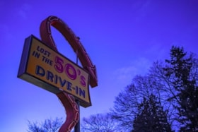
- Photograph of the historic "Arrow Neon Sign" at 50's Burgers, a restaurant located at 7741 Edmonds Street. The photograph depicts the sign, which reads: "Lost in the 50's Drive-In," against the sky at dusk.
- Repository
- City of Burnaby Archives
- Date
- 2022
- Collection/Fonds
- Disappearing Burnaby collection
- Physical Description
- 1 photograph (jpeg) : col.
- Description Level
- Item
- Record No.
- 634-029
- Access Restriction
- No restrictions
- Reproduction Restriction
- No restrictions
- Accession Number
- 2022-14
- Scope and Content
- Photograph of the historic "Arrow Neon Sign" at 50's Burgers, a restaurant located at 7741 Edmonds Street. The photograph depicts the sign, which reads: "Lost in the 50's Drive-In," against the sky at dusk.
- Media Type
- Photograph
- Photographer
- Cheung, Nakita
- Notes
- Title taken from the associated blog post
- Associated blog post: https://disappearingburnaby.wordpress.com/2022/06/30/lost-in-the-50s-drive-in/
- Geographic Access
- Edmonds Street
- Street Address
- 7741 Edmonds Street
- Historic Neighbourhood
- East Burnaby (Historic Neighbourhood)
- Planning Study Area
- Lakeview-Mayfield Area
Images
Opening of the Knight and Day Restaurant at Boundary and Lougheed Highway
https://search.heritageburnaby.ca/link/archivedescription59215
- Repository
- City of Burnaby Archives
- Date
- [1982]
- Collection/Fonds
- Columbian Newspaper collection
- Description Level
- Item
- Physical Description
- 1 photograph : b&w ; 8.5 x 18.5 cm
- Scope and Content
- Photograph of a sign advertising the new location of Knight & Day Restaurant opening in December. There is a long line of people lining up next to the restaurant in the background.
- Repository
- City of Burnaby Archives
- Date
- [1982]
- Collection/Fonds
- Columbian Newspaper collection
- Physical Description
- 1 photograph : b&w ; 8.5 x 18.5 cm
- Description Level
- Item
- Record No.
- 480-1530
- Access Restriction
- No restrictions
- Reproduction Restriction
- No restrictions
- Accession Number
- 2009-01
- Scope and Content
- Photograph of a sign advertising the new location of Knight & Day Restaurant opening in December. There is a long line of people lining up next to the restaurant in the background.
- Media Type
- Photograph
- Photographer
- King, Basil
- Notes
- Title based on contents of photograph
- Photographer's stamp on verso
- Note on verso reads: "PMT 100% / page 1 / Burnaby Today"
- Geographic Access
- Lougheed Highway
- Boundary Road
Images
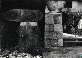
Exterior of 1665 Sherlock Avenue
https://search.heritageburnaby.ca/link/archivedescription78949
- Repository
- City of Burnaby Archives
- Date
- October 12,1976
- Collection/Fonds
- Burnaby Public Library Contemporary Visual Archive Project
- Description Level
- Item
- Physical Description
- 1 photograph : b&w ; 11 x 16 cm mounted on cardboard
- Scope and Content
- Photograph shows the homemade sign and garden ornament at 1665 Sherlock Avenue.
- Repository
- City of Burnaby Archives
- Date
- October 12,1976
- Collection/Fonds
- Burnaby Public Library Contemporary Visual Archive Project
- Physical Description
- 1 photograph : b&w ; 11 x 16 cm mounted on cardboard
- Description Level
- Item
- Record No.
- 556-044
- Access Restriction
- No restrictions
- Reproduction Restriction
- Reproduce for fair dealing purposes only
- Accession Number
- 2013-13
- Scope and Content
- Photograph shows the homemade sign and garden ornament at 1665 Sherlock Avenue.
- Media Type
- Photograph
- Photographer
- Born, A. J.
- Notes
- Scope note taken directly from BPL photograph description.
- 1 b&w copy negative : 10 x 12.5 cm accompanying
- Geographic Access
- Sherlock Avenue
- Street Address
- 1665 Sherlock Avenue
- Historic Neighbourhood
- Lochdale (Historic Neighbourhood)
- Planning Study Area
- Lochdale Area
Images
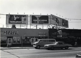
Mid-City Meats, Burnaby Christian Supply and Tommy's Produce
https://search.heritageburnaby.ca/link/archivedescription79226
- Repository
- City of Burnaby Archives
- Date
- September 15, 1976
- Collection/Fonds
- Burnaby Public Library Contemporary Visual Archive Project
- Description Level
- Item
- Physical Description
- 1 photograph : b&w ; 11 x 16 cm mounted on cardboard
- Scope and Content
- Photograph shows large billboards above Mid-City Meats, Burnaby Christian Supply and Tommy's Produce, located on Kingsway near Cassie Avenue. Burnaby Christian Supply was a music store prior to 1963 and Mid-City Meats was a drug store in the 1920s.
- Repository
- City of Burnaby Archives
- Date
- September 15, 1976
- Collection/Fonds
- Burnaby Public Library Contemporary Visual Archive Project
- Physical Description
- 1 photograph : b&w ; 11 x 16 cm mounted on cardboard
- Description Level
- Item
- Record No.
- 556-209
- Access Restriction
- No restrictions
- Reproduction Restriction
- Reproduce for fair dealing purposes only
- Accession Number
- 2013-13
- Scope and Content
- Photograph shows large billboards above Mid-City Meats, Burnaby Christian Supply and Tommy's Produce, located on Kingsway near Cassie Avenue. Burnaby Christian Supply was a music store prior to 1963 and Mid-City Meats was a drug store in the 1920s.
- Subjects
- Advertising Medium - Signs and Signboards
- Buildings - Commercial - Butcher Shops
- Buildings - Commercial - Grocery Stores
- Media Type
- Photograph
- Photographer
- McCarron, John
- Notes
- Scope note taken directly from BPL photograph description.
- 1 b&w copy negative : 10 x 12.5 cm accompanying
- Geographic Access
- Kingsway
- Cassie Avenue
- Historic Neighbourhood
- Central Park (Historic Neighbourhood)
- Planning Study Area
- Maywood Area


![Opening of the Knight and Day Restaurant at Boundary and Lougheed Highway, [1982] thumbnail](/media/Hpo/_Data/_Archives_Images/_Unrestricted/480/480-1530.jpg?width=280)
