Narrow Results By
Decade
- 2020s 2378
- 2010s 6261
- 2000s 9727
- 1990s 13489
- 1980s 12563
- 1970s 18309
- 1960s 12797
- 1950s 11060
- 1940s 7154
- 1930s 7853
- 1920s 11899
- 1910s 8577
- 1900s 4173
- 1890s 1859
- 1880s
- 1870s 125
- 1860s 176
- 1850s 45
- 1840s 24
- 1830s 14
- 1820s
- 1810s 8
- 1800s 11
- 1790s 6
- 1780s 5
- 1770s 5
- 1760s 5
- 1750s 5
- 1740s 5
- 1730s 5
- 1720s 5
- 1710s 7
- 1700s 6
- 1690s 5
- 1680s 6
- 1670s 4
- 1660s 4
- 1650s 4
- 1640s 4
- 1630s 4
- 1620s 4
- 1610s 4
- 1600s 4
- 1590s 1
- 1580s 1
- 1570s 1
- 1560s 1
- 1550s 1
- 1540s 1
- 1530s 1
- 1520s 2
- 1510s 1
- 1500s 1
- 1490s 1
- 1480s 1
Subject
- Adornment - Jewelry 1
- Aerial Photographs 8
- Animals - Cows 1
- Animals - Dogs 2
- Arts - Sculptures 1
- Buildings 2
- Buildings - Commercial 4
- Buildings - Commercial - Banks 3
- Buildings - Commercial - Grocery Stores 1
- Buildings - Commercial - Stores 1
- Buildings - Heritage 18
- Buildings - Industrial - Factories 1
Creator
- Archer, Frederic, 1838-1901 1
- Ballantyne, R. M. (Robert Michael), 1825-1894 1
- Barnes, R. 1
- Bateman, Caroline Mary Wettenhall 1
- Beck, James 1
- Beeton, Mrs. (Isabella Mary), 1836-1865 1
- Belfield, W. T. (William T.) 1
- Bell, David Charles, 1817-1901 1
- Browne, Gordon, 1858-1932 1
- Burnaby Village Museum 1
- Caldecott, Randolph, 1846-1886 1
- Chase, A. W. (Alvin Wood), 1817-1885 1
Person / Organization
- Aman, Sarah Tolson James 1
- Barnum, P.T. 1
- Bateman, Caroline Mary Wettenhall 2
- Bateman, Catherine "Cassie" Dale 1
- Bateman, Edwin W. 4
- Bateman, James 1
- Bateman, Marianne May 1
- Bingham, Alfred "Alf" 1
- Bossort, Kathy 1
- Burnaby Mountain Centennial Park 1
- Burnaby Mountain Conservation Area 1
- Burton, John 3

Barnet Neighbourhood
https://search.heritageburnaby.ca/link/landmark716
- Repository
- Burnaby Heritage Planning
- Associated Dates
- 1889-1904
- Heritage Value
- The North Pacific Lumber Company in Barnet was one of Burnaby's first industrial developments and one of the largest in the British Empire. Partners James MacLaren and Frank Ross built the mill in 1889 (activated in 1899) as a requirement for obtaining 84,000 acres of timber rights in northern BC. Due to the mill's isolation, the firm built homes for its employees with families and bunkhouses for the bachelors which separated Caucasian workers from Chinese and Sikh workers. Barnet became a distinct company town with its own general store, school, post office, community hall and telephone exchange.
- Historic Neighbourhood
- Barnet (Historic Neighbourhood)
- Planning Study Area
- Burnaby Mountain Area
Images


Aliceville
https://search.heritageburnaby.ca/link/landmark721
- Repository
- Burnaby Heritage Planning
- Associated Dates
- 1886
- Heritage Value
- Shortly after the townsite of Port Moody was surveyed in the early 1880s, a resort community developed on the border of Burnaby and Port Moody that would come to be called Aliceville. Located near the north end of North Road, in 1886 the Canadian Pacific Railway established a flag station there and the settlement was named after Alice May Webster who, with her sister Mrs. Jenns, operated the Aliceville Hotel.
- Historic Neighbourhood
- Barnet (Historic Neighbourhood)
- Planning Study Area
- Burnaby Mountain Area
Images

Evelyn Salisbury subseries
https://search.heritageburnaby.ca/link/archivedescription45
- Repository
- City of Burnaby Archives
- Date
- 1870 (date of original)-1991
- Collection/Fonds
- Burnaby Historical Society fonds
- Description Level
- Subseries
- Physical Description
- 2 m of textual records and other material
- Scope and Content
- Subseries consists of textual records and photographs that were collected by Lillian Evelyn Salisbury during her lifetime as a citizen of Burnaby. Records document historical sites and events in and related to Burnaby, as well as various heritage groups and events in British Columbia. Included in t…
- Repository
- City of Burnaby Archives
- Date
- 1870 (date of original)-1991
- Collection/Fonds
- Burnaby Historical Society fonds
- Subseries
- Evelyn Salisbury subseries
- Physical Description
- 2 m of textual records and other material
- Description Level
- Subseries
- Accession Number
- BHS1985-04
- BHS1985-15
- BHS1986-12
- BHS1986-25
- BHS1986-26
- BHS1987-04
- BHS1989-13
- BHS1989-18
- BHS1991-24
- Scope and Content
- Subseries consists of textual records and photographs that were collected by Lillian Evelyn Salisbury during her lifetime as a citizen of Burnaby. Records document historical sites and events in and related to Burnaby, as well as various heritage groups and events in British Columbia. Included in this subseries are the publication and papers related to "Metrotown - Burnaby Heritage Resource Inventory."
- History
- Lillian Evelyn "Evelyn" Salisbury was born in 1915 and moved to Burnaby in 1945. She had three children with her husband Fred: Gordon, Lorne, and Karen. While living in Burnaby, she worked with the Red Cross blood donor clinic and the Burnaby Health Unit. In 1958, she participated in the Greater Vancouver Health League’s campaign for fluoridation as the Health Chairman of the Burnaby Parent-Teacher Council. Evelyn Salisbury served two-year terms as secretary, vice-president and president of the Burnaby Historical Society and spearheaded a 1985 project to record Burnaby’s historical inventory of churches, schools, industries, homes and other pre-1930 buildings. When the building of Metrotown shopping centre threatened to clear historic homes in Central Park area, the Society produced a record of the historic buildings in the area. In 1988, as president of the Burnaby Historical Society, she convinced City of Burnaby aldermen to set up a heritage advisory committee. She was appointed to the Burnaby Centennial Committee the next year and in 1990 she was named Citizen of the Year by the Burnaby City Council. During her lifetime, Evelyn Salisbury endeavoured to collect papers of historical significance. She died in 1991.
- Media Type
- Textual Record
- Photograph
- Creator
- Salisbury, Evelyn
- Notes
- Title based on creator of subseries
- PC145, PC177, PC178, PC195, PC221, PC261, MSS061
Mayor's Office fonds
https://search.heritageburnaby.ca/link/archivedescription88
- Repository
- City of Burnaby Archives
- Date
- 1828 (date of original) -2015
- Collection/Fonds
- Mayor's Office fonds
- Description Level
- Fonds
- Physical Description
- 1 m of textual records and photographic material
- Scope and Content
- Fonds consists of those records created by the office of the Mayor during the administrations of Robert W. Prittie (1969-1973), Thomas W. Constable (1973-1979), David M. Mercier (1979-1981), William A. Lewarne (1981-1987), William J. Copeland (1987-1996), John Douglas Drummond (1996-2002) and Derek…
- Repository
- City of Burnaby Archives
- Date
- 1828 (date of original) -2015
- Collection/Fonds
- Mayor's Office fonds
- Physical Description
- 1 m of textual records and photographic material
- Description Level
- Fonds
- Access Restriction
- Subject to FOIPPA
- Reproduction Restriction
- Reproductions subject to FOIPPA
- Scope and Content
- Fonds consists of those records created by the office of the Mayor during the administrations of Robert W. Prittie (1969-1973), Thomas W. Constable (1973-1979), David M. Mercier (1979-1981), William A. Lewarne (1981-1987), William J. Copeland (1987-1996), John Douglas Drummond (1996-2002) and Derek Corrigan (2002-2018).
- History
- On September 22, 1892, the Corporation of the District of Burnaby was established by letters patent. An integral component of this incorporation was the creation of the office of the Reeve (later called Mayor). The Reeve was to serve as the Head and Chief Executive Officer of Burnaby and was to lead the City Council in the governing of the Corporation. Burnaby’s first Reeve and Council were elected by acclamation on October 15, 1892, with formal elections held by ballot three months later. From 1893 until 1977 the Reeve and Council were elected for one-year terms, but the practice of annual elections was abandoned in favour of two-year terms in 1977. The current practice of holding elections every three years was begun in 1987. Elections of Reeve and Council were suspended altogether in 1933. However, as a financial crisis in the Corporation resulted in the Province intervening and assuming control of the local government. For ten years, Commissioners were appointed by the Provincial Government to manage the affairs of the Municipality, but by January 1943, the situation had been remedied and local elections were once again held. From 1892 until 1968, the Chief Executive Officer in Burnaby was known as “Reeve,” but this nomenclature changed with revisions to the Local Government Act in the latter part of the twentieth century. In 1968, the Province altered the Act and abolished the practice of assigning different titles to the members of Council based on Municipal Classification and introduced "Mayor" and "Alderman" as terms applicable in all Municipalities not just those of a certain size or with a certain number of citizens. From that point on, the CEO of Burnaby has been referred to as the Mayor of the City. Despite these changes in election procedures, naming protocols, and the disruption caused by the financial crisis in the 1930s and 1940s, the roles and responsibilities of the Mayor have remained relatively stable throughout the years. As Head and Chief Executive Officer of the City, the Mayor is responsible for ensuring that the principles of law and good government are enforced in Burnaby. This includes the task of overseeing the conduct of officers and employees and directing the management of municipal business and affairs as well as chairing the meetings of Council and appointing Council Committee members. The Mayor is also charged with the duty of representing the City at public functions, in meetings with visiting dignitaries, and in participating in local community and fundraising events. Initially, the Municipal Clerk assisted the Mayor in his work by handling most correspondence and clerical tasks of the office. Today, however, the Mayor’s office retains its own administrative staff who are responsible for facilitating all schedules and arrangements for the Mayor along with coordinating their internal and external contacts and events. The following individuals have served as Reeve or Mayor of Burnaby: Charles R. Shaw 1892 Nicolai C. Shou 1893-1903 Charles F. Sprott 1904-1905 Peter Byrne 1906-1910 J. W. Weart 1911-1912 D. C. McGregor 1913 Hugh M. Fraser 1914-1918 T. Sanderson 1919-1920 Alexander K. McLean 1921-1926; 1928-1929 Charles C. Bell 1927 W. L. Burdick 1929 W. A. Pritchard 1930-1932 William Tate Wilson 1943-1944 George A. Morrison 1945-1949 William R. Beamish 1950-1953 Charles W. MacSorely 1954-1957 Alan H. Emmott 1958-1968 Robert W. Prittie 1969-1973 Thomas W. Constable 1973-1979 David M. Mercier 1979-1981 William A. Lewarne 1981-1987 William J. Copeland 1987-1996 Douglas P. Drummond 1996-2002 Derek Corrigan 2002-2018 Mike Hurley 2018-present The following individuals have served as provincially appointed Commissioners for the Corporation of the District of Burnaby: John Bennett 1932-1933 John Mahony 1933-1934 Hugh M. Fraser 1934-1940* R. S. Gilchrist 1941* B. C. Bracewell 1942* *Richard Bolton was Acting Commissioner for most of 1940-1942. He refused to be a full-fledged Commissioner.
- Media Type
- Textual Record
- Photograph
- Creator
- City of Burnaby
- Notes
- Title based on contents of fonds.
Peers Family and Hill Family fonds
https://search.heritageburnaby.ca/link/archivedescription98
- Repository
- City of Burnaby Archives
- Date
- [1880-1980]
- Collection/Fonds
- Peers Family and Hill Family fonds
- Description Level
- Fonds
- Physical Description
- ca. 1200 photographs and other material
- Scope and Content
- Fonds consists of records, primarily photographs, compiled by various members of both the Hill and Peers families that document their lives during the early days of settlement in Burnaby. The fonds includes records of citizenship, wills and other official papers pertaining to the life and activitie…
- Repository
- City of Burnaby Archives
- Date
- [1880-1980]
- Collection/Fonds
- Peers Family and Hill Family fonds
- Physical Description
- ca. 1200 photographs and other material
- Description Level
- Fonds
- Access Restriction
- No restrictions
- Accession Number
- 2007-12
- Scope and Content
- Fonds consists of records, primarily photographs, compiled by various members of both the Hill and Peers families that document their lives during the early days of settlement in Burnaby. The fonds includes records of citizenship, wills and other official papers pertaining to the life and activities of L. Claude Hill; photographs of the Peers family’s Burnaby Lake home, Greyfriars, and pictures taken by Arthur Peers during his work and travels throughout British Columbia in the first part of the 20th century; and photographs of the family of Claude Hill, early Burnaby Lake residents and scenes, and pictures Kitty took as an adult documenting the growth of her own family. Also included in this fonds are a number of photographs showing Yellow Point, Vancouver Island, where the Peers and Hill families often vacationed.
- History
- Bob Peers was born William John Peers, the son of real estate broker and early Burnaby resident, Francis John Peers and his wife Elizabeth Frisby. Originally from England, the family moved to Vancouver in 1905 and soon after settled at Burnaby Lake. The family included one daughter (Mary Elizabeth Dora) and four boys (Arthur Francis, William John “Bob”, Geoffrey Hugh, and Richard Dominic). When they arrived in Burnaby, Francis Peers purchased a piece of land from another early settler, Claude Hill, and built the family home “Greyfriars” near Deer Lake. The children attended school in the home of Miss Harriet Woodward, the first school to be held in the Burnaby Lake area. In 1925, Bob married Claude Hill’s daughter and another former pupil of “Miss Harry’s,” Kitty Hill. Kitty (born Katherine Maude Hill) was the only child of Burnaby pioneers L. Claude Hill and Annie Sara Kenrick. Having moved to the Burnaby Lake area in the early 1890s, Claude went on to operate a successful strawberry farm and soon became active in the political development of Burnaby – being elected to the first Burnaby Council and serving from 1892-1894 and again from 1909-1910. The first Hill family home, “Brookfield,” was sold around 1907 and the family moved to their new home, “Broadview,” which was also built in the vicinity of Deer Lake. In 1925, Bob and Kitty were married and they went on to have three children, Robert C.K., Barbara (later Barbara Jeffrey), and Anne (later Anne Latham).
- Formats
- All photographic records have been scanned and are saved in jpeg format on the City of Burnaby network. Archival master copies have also been produced in tiff format and have been burned to CD for preservation purposes.
- Media Type
- Textual Record
- Photograph
- Creator
- Peers family
- Hill family
- Notes
- Title based on contents of fonds
Silver family subseries
https://search.heritageburnaby.ca/link/archivedescription120
- Repository
- City of Burnaby Archives
- Date
- 1883-1937
- Collection/Fonds
- Burnaby Historical Society fonds
- Description Level
- Subseries
- Physical Description
- 2 files of textual records and 3 photographs
- Scope and Content
- Subseries consists of miscellaneous papers and photographs related to the Silver family of McKay District.
- Repository
- City of Burnaby Archives
- Date
- 1883-1937
- Collection/Fonds
- Burnaby Historical Society fonds
- Subseries
- Silver family subseries
- Physical Description
- 2 files of textual records and 3 photographs
- Description Level
- Subseries
- Accession Number
- BHS1986-22
- BHS2007-04
- Scope and Content
- Subseries consists of miscellaneous papers and photographs related to the Silver family of McKay District.
- History
- William Frederick and Kenneth Oliver Silver were both machinists in Burnaby, and were co-owners of the Silver Brothers Garage at Kingsway and Silver Avenue. William Frederick Silver was married to Isabella June McKinnon in 1883. Their son Hugh went to Kingsway West. William died December 26, 1943. Hugh died March 26, 1971.
- Media Type
- Textual Record
- Photograph
- Notes
- PC173, MSS011, and MSS025
- Title based on contents of subseries
Mayor's Office General and Administration series
https://search.heritageburnaby.ca/link/archivedescription158
- Repository
- City of Burnaby Archives
- Date
- 1828 (date of original) -2002
- Collection/Fonds
- Mayor's Office fonds
- Description Level
- Series
- Scope and Content
- Series consists of records created in the administration of the Mayor’s Office. This includes: reports, file lists, address books, subject files, correspondence, memoranda, photographs and ephemera. The Office of the Mayor is managed by an administrative staff who maintain the Mayor’s schedule, l…
- Repository
- City of Burnaby Archives
- Date
- 1828 (date of original) -2002
- Collection/Fonds
- Mayor's Office fonds
- Description Level
- Series
- Scope and Content
- Series consists of records created in the administration of the Mayor’s Office. This includes: reports, file lists, address books, subject files, correspondence, memoranda, photographs and ephemera. The Office of the Mayor is managed by an administrative staff who maintain the Mayor’s schedule, liaise with other City officials, and assist the Mayor fulfill his duties and responsibilities to the citizens of Burnaby. As a by-product of these activities, the Mayor’s Office maintains files related to general administrative tasks like record-keeping as well as collecting subject files and records of general interest to the Mayor and Council. These records were used as reference material and have been maintained for their informational value.
- Media Type
- Textual Record
Kitty Hill Peers family photograph series
https://search.heritageburnaby.ca/link/archivedescription165
- Repository
- City of Burnaby Archives
- Date
- [1880-1940]
- Collection/Fonds
- Peers Family and Hill Family fonds
- Description Level
- Series
- Physical Description
- ca. 1000 photographs
- Scope and Content
- Series consists of photographs taken by members of the Hill family during their first years of settlement in Burnaby. Photographs depict various members of the Hill family including Burnaby pioneers L. Claude Hill, his brother Bernard Hill and their families. Photographs also show numerous social…
- Repository
- City of Burnaby Archives
- Date
- [1880-1940]
- Collection/Fonds
- Peers Family and Hill Family fonds
- Physical Description
- ca. 1000 photographs
- Description Level
- Series
- Access Restriction
- No restrictions
- Reproduction Restriction
- May be restricted by third party rights
- Scope and Content
- Series consists of photographs taken by members of the Hill family during their first years of settlement in Burnaby. Photographs depict various members of the Hill family including Burnaby pioneers L. Claude Hill, his brother Bernard Hill and their families. Photographs also show numerous social events in Burnaby and many of the earliest residents, particularly in the Deer Lake and Burnaby Lake areas. Also included in the series are photographs taken and compiled by Claude Hill’s daughter Kitty which include her life and activities after her marriage to William John “Bob” Peers and the growth of their family.
- Media Type
- Photograph
Legal document and certificate series
https://search.heritageburnaby.ca/link/archivedescription166
- Repository
- City of Burnaby Archives
- Date
- [1867-1961]
- Collection/Fonds
- Peers Family and Hill Family fonds
- Description Level
- Series
- Physical Description
- 2 cm textual records
- Scope and Content
- Series consists of legal documents including as wills, birth certificates and military papers pertaining to Claude Hill and Annie Sara (Kenrick) Hill. Documents also include a diary kept by Claude, a few pieces of correspondence, ledgers related to Claude's land transactions and certificates of ci…
- Repository
- City of Burnaby Archives
- Date
- [1867-1961]
- Collection/Fonds
- Peers Family and Hill Family fonds
- Physical Description
- 2 cm textual records
- Description Level
- Series
- Access Restriction
- No restrictions
- Reproduction Restriction
- May be restricted by third party rights
- Accession Number
- 2007-12
- Scope and Content
- Series consists of legal documents including as wills, birth certificates and military papers pertaining to Claude Hill and Annie Sara (Kenrick) Hill. Documents also include a diary kept by Claude, a few pieces of correspondence, ledgers related to Claude's land transactions and certificates of citizenship and identification. Also in the file is a sketch showing a “Birds Eye View of the Burnaby Lake Area circa 1910,” a book of Common Prayer Hymns, a Bible, a Post Card Album, address book, a Birthday Book and a cross-stitch sampler done by Annie Kenrick in 1877.
- Media Type
- Textual Record
Silver Brothers papers
https://search.heritageburnaby.ca/link/archivedescription57747
- Repository
- City of Burnaby Archives
- Date
- 1883-1931
- Collection/Fonds
- Burnaby Historical Society fonds
- Description Level
- File
- Physical Description
- 1 file of textual records
- Scope and Content
- File consists of papers pertaining to William Fredrick and Kenneth Oliver Silver, brothers, who were both machinists in Burnaby. Included in the papers is a marriage certificate from 1883 between William Fredrick Sliver and Isabella June Mc Kinnon, a cheque from 1911 signed by W.F. Silver and a cus…
- Repository
- City of Burnaby Archives
- Date
- 1883-1931
- Collection/Fonds
- Burnaby Historical Society fonds
- Subseries
- Silver family subseries
- Physical Description
- 1 file of textual records
- Description Level
- File
- Record No.
- MSS011-001
- Accession Number
- BHS2007-04
- Scope and Content
- File consists of papers pertaining to William Fredrick and Kenneth Oliver Silver, brothers, who were both machinists in Burnaby. Included in the papers is a marriage certificate from 1883 between William Fredrick Sliver and Isabella June Mc Kinnon, a cheque from 1911 signed by W.F. Silver and a customs form permitting a 1927 Pierce-Arrow sedan into Canada.
- Media Type
- Textual Record
- Notes
- Title based on contents of file
McClean family
https://search.heritageburnaby.ca/link/museumdescription2816
- Repository
- Burnaby Village Museum
- Date
- 1888
- Collection/Fonds
- Hawkshaw family fonds
- Description Level
- Item
- Physical Description
- 1 photograph : sepia ; 14.5 x 11 cm
- Scope and Content
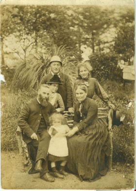
- Photograph of the McClean family gathered together at a wooden bench on their property in Wexford, Ireland. Mr. Washington Gilliland McClean and Mrs. Honor Delamore McClean are seated on the bench, holding their youngest child, Mabel (she is blurred because she was moving while the photograph was b…
- Repository
- Burnaby Village Museum
- Collection/Fonds
- Hawkshaw family fonds
- Description Level
- Item
- Physical Description
- 1 photograph : sepia ; 14.5 x 11 cm
- Scope and Content
- Photograph of the McClean family gathered together at a wooden bench on their property in Wexford, Ireland. Mr. Washington Gilliland McClean and Mrs. Honor Delamore McClean are seated on the bench, holding their youngest child, Mabel (she is blurred because she was moving while the photograph was being taken). Standing behind them are Mabel’s older brother Charles McClean and sisters; Elsie and Evangeline Mai "Eva" McClean.
- Names
- Hawkshaw, Mabel Edith Honor McClean
- McClean, Charles
- Goff, Evangeline "Mai" McClean
- Rae, Elsie McClean
- McClean, Honor Delamore
- McClean, Washington Gilliland
- Accession Code
- BV996.6.291
- Access Restriction
- No restrictions
- Reproduction Restriction
- No known restrictions
- Date
- 1888
- Media Type
- Photograph
- Scan Resolution
- 600
- Scan Date
- 2/24/2011
- Scale
- 100
- Notes
- Title based on contents of photograph
- Note on verso of photograph reads: “Grandfather McClean / Mabel McClean / Grandmother McClean / Front Row / 1888 / Wexford Ireland / Back Row / Elise, Charles + Eva / McClean / Older sisters and brother”
Images

![Seated woman, [188-] thumbnail](/media/hpo/_Data/_BVM_Images/1977/197900500159.jpg?width=280)
Seated woman
https://search.heritageburnaby.ca/link/museumdescription3035
- Repository
- Burnaby Village Museum
- Date
- [188-]
- Collection/Fonds
- Hugh H. Stewart fonds
- Description Level
- Item
- Physical Description
- 1 photograph : b&w tinype ; 9.1 x 6.5 cm
- Scope and Content
- Photograph of an unidentified middle-aged woman with her hair parted in the middle and tied back, wearing a gingham dress and sitting on a chair.
- Repository
- Burnaby Village Museum
- Collection/Fonds
- Hugh H. Stewart fonds
- Description Level
- Item
- Physical Description
- 1 photograph : b&w tinype ; 9.1 x 6.5 cm
- Scope and Content
- Photograph of an unidentified middle-aged woman with her hair parted in the middle and tied back, wearing a gingham dress and sitting on a chair.
- History
- The woman in the photograph is likely Henrietta Stewart, mother of Hugh H. Stewart. She was born in 1860 in France. She married Duncan Hugh Stewart in Pennslyvania and eventually immigrated to Canada, settling in Nanaimo in 1888/1889. The family later moved to Vancouver. She had four children: Hugh Henry, Kate, Kenneth and Duncan.
- Accession Code
- HV979.50.159
- Access Restriction
- No restrictions
- Reproduction Restriction
- No known restrictions
- Date
- [188-]
- Media Type
- Photograph
- Scan Resolution
- 600
- Scan Date
- 2023-09-12
- Notes
- Title based on contents of photograph
Images
![Seated woman, [188-] thumbnail](/media/hpo/_Data/_BVM_Images/1977/197900500159.jpg)
![Ontario Liquor Store, [between 1880 and 1899] thumbnail](/media/hpo/_Data/_BVM_Images/1974/1974_0130_0056_001.jpg?width=280)
Ontario Liquor Store
https://search.heritageburnaby.ca/link/museumdescription3061
- Repository
- Burnaby Village Museum
- Date
- [between 1880 and 1899]
- Collection/Fonds
- Burnaby Village Museum Photograph collection
- Description Level
- Item
- Physical Description
- 1 photograph : b&w tintype ; 10.6 x 13.8 cm
- Scope and Content
- Photograph of an L shaped building with a flat front. Letters on the front of the store read, "Ontario Liquor Store / Grocery / Tailor." Four men are standing near the store on the boardwalk, three boys are sitting, and a woman is standing on the boardwalk leaning against the fence on the far lef…
- Repository
- Burnaby Village Museum
- Collection/Fonds
- Burnaby Village Museum Photograph collection
- Description Level
- Item
- Physical Description
- 1 photograph : b&w tintype ; 10.6 x 13.8 cm
- Scope and Content
- Photograph of an L shaped building with a flat front. Letters on the front of the store read, "Ontario Liquor Store / Grocery / Tailor." Four men are standing near the store on the boardwalk, three boys are sitting, and a woman is standing on the boardwalk leaning against the fence on the far left. As is normal for most tintypes, the image appears reversed, left to right. (Few tintype cameras included a mirror or prism that made the image appear 'right way round').
- History
- From Denby Bros. Shoe Store at 163 West Pender in Vancouver. Stafford Ague Denby (1882-1957) started peddling shoe findings in 1918 around Vancouver to repair shops around town from the back of an old Ford. Two of his brothers, William Albert (1873-1947) and Melvin Stanley (1879-1953) joined him in 1919 to form Denby Bros & Co. Ltd Leather and Shoe Findings at 163 West Pender. William Gordon Pope started helping out in the shoe store at the age of 10. He eventually ran the store with his cousin, Pat Denby (son of William A. Denby) starting in the 1950s. The store closed in 1974.
- Subjects
- Buildings - Commercial - Stores
- Accession Code
- HV974.130.56
- Access Restriction
- No restrictions
- Reproduction Restriction
- No known restrictions
- Date
- [between 1880 and 1899]
- Media Type
- Photograph
- Scan Resolution
- 600
- Scan Date
- 2023-05-09
- Scale
- 100
- Notes
- Title based on contents of photograph
Images
![Ontario Liquor Store, [between 1880 and 1899] thumbnail](/media/hpo/_Data/_BVM_Images/1974/1974_0130_0056_001.jpg)
Phineas Taylor Barnum
https://search.heritageburnaby.ca/link/museumdescription3348
- Repository
- Burnaby Village Museum
- Date
- 1886
- Collection/Fonds
- Burnaby Village Museum Photograph collection
- Description Level
- Item
- Physical Description
- 1 photograph : b&w ; 14.5 x 9.5 cm mounted on cardboard 16.5 x 10.7 cm
- Scope and Content
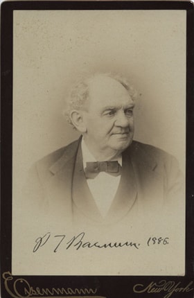
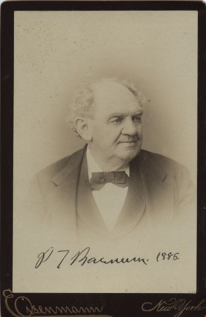
- Photograph of Phineas Taylor Barnum (1810-1891), the founder of the circus that would eventually become the Ringling Brothers and Barnum and Bailey Circus. He is 76 years of age at this time with grey hair, wearing a suit with a vest and a bow tie. Annotated or stamped on the bottom front of the ph…
- Repository
- Burnaby Village Museum
- Collection/Fonds
- Burnaby Village Museum Photograph collection
- Description Level
- Item
- Physical Description
- 1 photograph : b&w ; 14.5 x 9.5 cm mounted on cardboard 16.5 x 10.7 cm
- Scope and Content
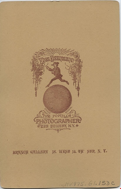
- Photograph of Phineas Taylor Barnum (1810-1891), the founder of the circus that would eventually become the Ringling Brothers and Barnum and Bailey Circus. He is 76 years of age at this time with grey hair, wearing a suit with a vest and a bow tie. Annotated or stamped on the bottom front of the photograph: "P.T. Barnum. 1886." Printed on the bottom front of the card: "Eisenmann / New York." Printed on the back of the card, "Chas. Eisenmann / Instantaeous Photographer / Trade Mark / The Popular Photographer / 229 Bowery, N.Y. / Branch Gallery 18 West 14th Str. N.Y."
- Names
- Barnum, P.T.
- Accession Code
- HV975.61.153c
- Access Restriction
- No restrictions
- Reproduction Restriction
- No known restrictions
- Date
- 1886
- Media Type
- Photograph
- Scan Resolution
- 600
- Scan Date
- 2023-06-06
- Photographer
- Eisenmann, Charles
- Notes
- Title based on contents of photograph
- This photograph was removed from photograph album - HV975.61.153
Images
![Subdivision plans in New Westminster District Group 1 – Burnaby
, [1882-1910] thumbnail](/media/hpo/_Data/_BVM_Cartographic_Material/1977/1977_0093_0013a_001.jpg?width=280)
Subdivision plans in New Westminster District Group 1 – Burnaby
https://search.heritageburnaby.ca/link/museumdescription6982
- Repository
- Burnaby Village Museum
- Date
- [1882-1910]
- Collection/Fonds
- Burnaby Village Museum Map collection
- Description Level
- File
- Physical Description
- 4 plans : blueprint on paper mounted on 2 sides of cardboard 76 x 102 cm
- Scope and Content
- Item consists of a large board of two New Westminster District Gp 1 - subdivision plans mounted on one side and two New Westminster District Gp 1 - subdivision plans mounted on the other side. Side A: 1. Blueprint "Plan / of the / Subdivision / of / Lot 98 / G.1, N.W.D. / Scale 4 chs = 1 in. / …
- Repository
- Burnaby Village Museum
- Collection/Fonds
- Burnaby Village Museum Map collection
- Description Level
- File
- Physical Description
- 4 plans : blueprint on paper mounted on 2 sides of cardboard 76 x 102 cm
- Material Details
- Scales [between 1:1584 and 1:3168]
- Index number on edge of board reads: "13"
- Scope and Content
- Item consists of a large board of two New Westminster District Gp 1 - subdivision plans mounted on one side and two New Westminster District Gp 1 - subdivision plans mounted on the other side. Side A: 1. Blueprint "Plan / of the / Subdivision / of / Lot 98 / G.1, N.W.D. / Scale 4 chs = 1 in. / Map No 573" (Geographic location: Burnaby) 2. Blueprint "Plan / of Subdivision of / Lot 157 / Gr.1, New. West. Dist. / Scale 3 chs = 1 in. / Map No. 612". (Geographic location: Burnaby) Side B: 1. Blueprint "Plan / of Subdivision / of a Portion of / Lot 90 / Group One / New Westminster Dist. / Scale 2 chs = 1 in. / Map No. 555". Plan is signed by "Jno Strathern [sic]_P.L.S."n (Geographic location: Burnaby) 2. Blueprint "Subdivision of Lot 31, Group 1. / New Westminster District / As Amended by Order of Court / 1st Sept. 1882 and Numbered 847 / Scale 4 chs = 1in. / Map No 80" (Geographic location: Burnaby)
- Creator
- Stathern, John
- Accession Code
- HV977.93.13
- Access Restriction
- No restrictions
- Reproduction Restriction
- No known restrictions
- Date
- [1882-1910]
- Media Type
- Cartographic Material
- Historic Neighbourhood
- Alta Vista (Historic Neighbourhood)
- Planning Study Area
- Richmond Park Area
- Lakeview-Mayfield Area
- Scan Resolution
- 300
- Scale
- 72
- Notes
- Title based on contents of file
- Scale is measured in chains. (One chain equals 792 inches)
- The term "Lot" can also refer to a "District Lot”
Images
![Subdivision plans in New Westminster District Group 1 – Burnaby
, [1882-1910] thumbnail](/media/hpo/_Data/_BVM_Cartographic_Material/1977/1977_0093_0013a_001.jpg)

![Survey and Subdivision plans in New Westminster District Group 1 – Burnaby
, [1861]-[1910] thumbnail](/media/hpo/_Data/_BVM_Cartographic_Material/1977/1977_0093_0019a_001.jpg?width=280)
Survey and Subdivision plans in New Westminster District Group 1 – Burnaby
https://search.heritageburnaby.ca/link/museumdescription6988
- Repository
- Burnaby Village Museum
- Date
- [1861]-[1910]
- Collection/Fonds
- Burnaby Village Museum Map collection
- Description Level
- File
- Physical Description
- 14 plans : 3 plans : black ink on paper hand col. + 7 plans : black ink on paper + 4 plans : graphite on paper mounted on 2 sides of cardboard 76 x 102 cm
- Scope and Content
- Item consists of a large board of four New Westminster District Gp 1 - subdivision plans mounted on one side and ten New Westminster District Gp 1 - subdivision plans mounted on the other side. Side A: 1. "Plan /of / Lots 166A, 166 and 167 /, Gr.1, N.W.D. / Showing Misconstructed Roads in Gree…
- Repository
- Burnaby Village Museum
- Collection/Fonds
- Burnaby Village Museum Map collection
- Description Level
- File
- Physical Description
- 14 plans : 3 plans : black ink on paper hand col. + 7 plans : black ink on paper + 4 plans : graphite on paper mounted on 2 sides of cardboard 76 x 102 cm
- Material Details
- Scales [between 1:2376 and 1:7920]
- Index number on edge of board reads: "19"
- Scope and Content
- Item consists of a large board of four New Westminster District Gp 1 - subdivision plans mounted on one side and ten New Westminster District Gp 1 - subdivision plans mounted on the other side. Side A: 1. "Plan /of / Lots 166A, 166 and 167 /, Gr.1, N.W.D. / Showing Misconstructed Roads in Green / 5 chs = 1 in.". (plan is drawn in black ink and hand coloured in red, green and orange ink). A section in the centre of the plan is coloured in red ink and identified as "C.S. Richmond" running from the North Arm of Fraser River to Wiggins Road and divided by "New Wiggins Rd. (as gazetted)" (coloured in orange ink) and two"Constructed Road(s)" (coloured in green ink). Plan is initialed by: "RB" [sic] (in blue pencil crayon) 2. Plan of / Subdivision of / Lot 166 / Group One / New Westminster District / Scale 4 chs = 1 in. / Map No 524". Plan is drawn in graphite and signed by "Surrig [sic] Welhams [sic] / P.L.S." Plan is initialed by: "RB" [sic] (in blue pencil crayon) 3. Plan of "Survey / of Highway / For / Burnaby Council / in / Lots 13 _14 / Group One / Scale 4 chs = 1 in." Signed by "Albert J. Hill, P.L.S." Caribou Street and Caribou Road run through the centre of the plan. Plan is stamped: "Albert J. Hill, Civil Engineer / and / Provincial Land Surveyor, / New Westminster, / B.C.". Plan is initialed by: "RB" [sic] (in blue pencil crayon) 4. A Plan of Lots 166A, 166 and 167, Group One, New Westminster District (drawn in graphite). A section in the centre of the plan is identified as "C.S. Richmond" running from the North Arm of Fraser River and divided by "New Wiggins Rd. (as gazetted)" and two "Constructed Road(s)". Plan is initialed by: "RB" [sic] (in blue pencil crayon) Side B: 1. Small plan drawn in black ink (no title) identifying lots north of the "North Arm" of the Fraser River. Lots identified include: Lot 99, Lot 98, Lot 157, Lot 158, Lot 163, Lot 162, Lot 159, Lot 163, Lot 162, Lot 165, Lot 166A, Lot 155B, Lot 155A and Lot 159. "Scale 40 chains to one inch" . Plan is initialed by: "RB" [sic] (in blue pencil crayon) (Geographic location: Burnaby) 2. Small plan drawn in black ink (no title) identifying lots north of the North Arm of the Fraser River as "Lots 155, 155A, 155B, 155C, 162, 163, 164, 165, 166A and 167". Plan is initialed by: "RB" [sic] (in blue pencil crayon) (Geographic location: Burnaby) 3. Small plan drawn in black ink (no title) which identifies "Lot 151 / Reserve/ for / Race Course"; "Reserve / 64 A / L. 152 G.1"; and other Lots: 32, 33, 34, 35, 36, 38, 39. The plan is signed "Surveyor G.Turn [sic] July / 61 / from Vol 40 R.L. notes [sic]" Plan is stamped: "Albert J. Hill, Civil Engineer / and / Provincial Land Surveyor, / New Westminster, / B.C." Plan is initialed by: "RB" [sic] (in blue pencil crayon) (Geographic location: Burnaby) 4. Small plan drawn in black in with faded red colouring on centre lot identified as "Lot 34" running north from "Vancouver Road" . Plan is stamped: "Albert J. Hill, Civil Engineer / and / Provincial Land Surveyor, / New Westminster, / B.C." Plan is initialed by: "RB" [sic] (in blue pencil crayon) (Geographic location: Burnaby) 5. Plan drawn in graphite and identified as "Lot 98, Gr.1," along with the intials "RB" [sic] (both are handwritten in blue crayon pencil on top of plan) The B.C.E.Railway is identified running through the plan along with Jubilee Road and Royal Oak Road. The plan is signed with the name "Wm. Murray" and the Plan is stamped: "Albert J. Hill, Civil Engineer / and / Provincial Land Surveyor, / New Westminster, / B.C.". (Geographic location: Burnaby) 6. Plan drawn in graphite identified as "Port Lot 13, Gr.1" along with the intials "RB" [sic] (both are handwritten in blue crayon pencil on top of plan) Plan is stamped: "Albert J. Hill, Civil Engineer / and / Provincial Land Surveyor, / New Westminster, / B.C.". (Geographic location: Burnaby) 7.Plan drawn in black ink and identified as "Lot 98 G.1" along with the intials "RB" [sic] (both are handwritten in blue crayon pencil on top of plan). A "Road Reservation" is identified running north between "Electric Tramway" and connecting with "Royal Oak Road". Plan is stamped: "Albert J. Hill, Civil Engineer / and / Provincial Land Surveyor, / New Westminster, / B.C." (Geographic location: Burnaby) 8. Plan drawn in black ink and divided into two sections, the upper plan is identified as "Portion / Lots 100 / area / 101, Gr.1" and the lower plan is identified as "Portion L. 3 G. 1" along with the intials "RB" [sic] (these identifiers are handwritten in blue crayon pencil on top of the plan). Portions of Lot 100 and Lot 101 are each divided into 6 sections and the Portion of Lot 3 plan is divided into 24 sections. The plan includes a note in black ink that reads: " Received from Wm Fromme [sic] / from Wm. Trapp / Nov. 28, 1895 / A. J. T...[sic]". (Geographic location: Burnaby) 9. Plan drawn in black ink (no title) identifying soil, buildings and geographic features in southern Burnaby. The plan is bordered by "New Westminster City" (Tenth Avenue and DL 172) to the south east and DL 173 to the south, DL 158 to the west and the B.C.E. Tramway to the north. Plan includes District Lots: 155A, 158, 159, 171, 160, 53 and 95 and identifies soil, marshland and ravines throughout. Plan identifies the following features: a "Team Road" running through Lots 158 and 159 along with "Fair Orchard Soil / Even Surface Throughout / No Ravines", "Gravel and Shingle" (bottom of Lot 158), "North Arm Road" crossing "Byrne Road" and connecting with "Power House Road" which runs north to connect with "Highland Park Station" and the B.C.E. Tramway, "Power Ho" in the northeast corner of DL 160, a "Brook" connected with a "Deep Ravine" running between DL 53, DL 95 and DL 160 along with "Good Soil" and "Fair Orchard Soil" identified nearby in DL 95. Scale is identified as "10 chs = 1 in." Plan is stamped: "Albert J. Hill, Civil Engineer / and / Provincial Land Surveyor, / New Westminster, / B.C." Plan is initialed by: "RB" [sic] (in blue pencil crayon) (Geographic location: Burnaby) 10. Plan drawn in black ink (no title) with Burnaby Lake and Deer Lake at the centre. The plan is bordered by the following District Lots identified as: 117, 118 and 68 to the west, Lots 80, 79 and 85 to the southwest, Lots 11, 13, and 1 (City of New Westminster) to the south east, the North Road boundary to the east and Lots 8, 56, 57, 59, and 136 to the North. The lower right hand corner of the plan has a small inset which reads: "Burnaby Lake" and "Page 19 R.B. Notes". Plan is initialed by: "RB" [sic] (in blue pencil crayon) (Geographic location: Burnaby)
- Creator
- Hill, Albert James
- Accession Code
- HV977.93.19
- Access Restriction
- No restrictions
- Reproduction Restriction
- No known restrictions
- Date
- [1861]-[1910]
- Media Type
- Cartographic Material
- Scan Resolution
- 300
- Scale
- 72
- Notes
- Title based on contents of file
- Scale is measured in chains. (One chain equals 792 inches)
- The term "Lot" can also refer to a "District Lot”
- Some plans are stamped: "Albert J. Hill, Civil Engineer / and / Provincial Land Surveyor, / New Westminster, / B.C." and intialed: "RB" [sic]
Images
![Survey and Subdivision plans in New Westminster District Group 1 – Burnaby
, [1861]-[1910] thumbnail](/media/hpo/_Data/_BVM_Cartographic_Material/1977/1977_0093_0019a_001.jpg)

![Survey and Subdivision plans in New Westminster District Group 1 – Burnaby, Port Moody, [1862-1908] thumbnail](/media/hpo/_Data/_BVM_Cartographic_Material/1977/1977_0093_0026a_001.jpg?width=280)
Survey and Subdivision plans in New Westminster District Group 1 – Burnaby, Port Moody
https://search.heritageburnaby.ca/link/museumdescription6995
- Repository
- Burnaby Village Museum
- Date
- [1862-1908]
- Collection/Fonds
- Burnaby Village Museum Map collection
- Description Level
- File
- Physical Description
- 9 plans : 6 plans : black ink on paper ; 57 x 36.5 cm or smaller + 1 plan : black ink and grahite on paper ; 46.5 x 49 cm + 1 plan : blueprint on paper ; 15.5 x 19.5 cm + cm + 1 plan : graphite on paper ; 25 x 17 cm ; mounted on both sides of board 76 x 102 cm
- Scope and Content
- Item consists of a large board of four New Westminster District subdivision plans mounted on one side and five New Westminster District subdivision plans mounted on the other side. Side A: 1. "Plan / of Subdivision / of a Portion / of / Lot 87 / Group One / New Westminster District / Scale 4 chs…
- Repository
- Burnaby Village Museum
- Collection/Fonds
- Burnaby Village Museum Map collection
- Description Level
- File
- Physical Description
- 9 plans : 6 plans : black ink on paper ; 57 x 36.5 cm or smaller + 1 plan : black ink and grahite on paper ; 46.5 x 49 cm + 1 plan : blueprint on paper ; 15.5 x 19.5 cm + cm + 1 plan : graphite on paper ; 25 x 17 cm ; mounted on both sides of board 76 x 102 cm
- Material Details
- Scales [between 1:792 and 1:3600]
- Index number on edge of board reads: "26"
- Scope and Content
- Item consists of a large board of four New Westminster District subdivision plans mounted on one side and five New Westminster District subdivision plans mounted on the other side. Side A: 1. "Plan / of Subdivision / of a Portion / of / Lot 87 / Group One / New Westminster District / Scale 4 chs = 1 in". Plan is stamped: "Albert J. Hill, Civil Engineer / and / Provincial Land Surveyor, / New Westminster, / B.C." and intialed by: "RB" [sic] (in blue pencil crayon). Names two of the subdivisons of District Lot 87 are identified as, "L.E. Sprott" and "John Ledger". (Geographic location: Burnaby) 2. "Plan of Subdivision / of / Portions of / Lot 136, 131 and Lots 44 and 78 Gr.1 / New Westminster District / Scale 300 ft = 1 inch". Annotation above title reads: "No. 901 / Deposited in Land Registry Office / New Westminster / Aug. 19th 1905 / Charles S. Keith D. Reg." Annotations and signatures at bottom of plan read: "I, William Nelson Draper, / W.H.R. Collister / Charles E. Perkins / E.B. Morgan / make / Surveys / correct / representation / upon / the / Land Registry Act / (sgd) W.N. Draper, P.L.S.". Plan includes a handwritten title: "Lots 136, 131, 44 & 78" and is initialed: "RB" [sic] (in blue pencil crayon) (Geographic location: Burnaby) 3. "Survey / of / a Portion / of / Lot 95, Gr.1 / Scale 1 ch = 1in." Plan is stamped: "Albert J. Hill, Civil Engineer / and / Provincial Land Surveyor, / New Westminster, / B.C." and is initialed : "RB" [sic] (in blue pencil crayon) (Geographic location: Burnaby) 4. Blueprint plan of "Lot 396. Group One." with Scale : 3 chs = 1 in. A two acre portion of District Lot 396 is filled in with red ink." Plan is signed by "Albert J. Hill / B.C.L.S." (Geographic location: Port Moody) Side B: 1. Plan titled "District Lot 92 / Burnaby / Municipality / for sale by / Mahon / McFarland & / Mahon Ltd. / Vancouver, B.C. / Scale : 4 chains to one inch". District Lot 92 is subdivided into 161 lots and identifies roads: Norwich Road, Pole Line Road, Oakland Road, Stanley Road, Burford Road, Dalhousie Road, Brantford Road, Colborne Road, Roberts Road, Vancouver & Westminster Road, B.C. Electric Railway, Gilley Stn. and Burnaby (Power House). The bottom of the plan reads: "G.S. Dawson, P.LS. Vancouver, B.C." (Geographic location: Burnaby) 2. "Plan / of Subdivision / of a Portion / of / Lot 29 / Group 1 / New Westminster District / Scale 2 chs = 1 in". Plan is stamped: "Albert J. Hill, Civil Engineer / and / Provincial Land Surveyor, / New Westminster, / B.C." and is initialed by: "RB" [sic] (in blue pencil crayon) (Geographic location: Burnaby) 3. Small handrawn plan (no title) identifying "Lot 84 / Hydes, Claim" at the centre surrounded by lots and features identified as: "Lot 85", "Lot 93", "Lot 94", "Lot 32", "Lot 82", "Lot 83", "Lot 79", "swamp" and a "Small Lake" (Burnaby Lake). Identifying marks in the right corner of the plan read: "Page 13 / Surveyed by G. Turner / May 62". Plan also includes surveyor's bearing measurements and trails to "Small Lake" (Burnaby Lake). (Geographic location: Burnaby) 4. Untitled plan showing District Lots west of North Road and north of Burnaby Lake including: Lots 2, 4, 6, 8, 15, 10, 56, 148, 57, 58, 40. and Lots 3, 5, 7 east of North Road (Coquitlam). Lots in Burnaby are identifed for timber including: "Heavily Timbered" (Lot 57), " "Some Fir and Cedar" (Lot 40), "Splendid Fir and Cedar" (Lot 143), "Heavy Fir etc" (Lots 143 and 148), " "Fine Cedar" (Lot 15), "Rough Light Timber" (Lot 56). Other features identified at the lower portion of the plan include "Burnaby Lake" and "Brunette River". (Geographic location: Burnaby) 5. Untitled plan drawn in graphite showing sections of District Lot 85 south of Burnaby Lake and north of Hazsard Road. Plan is signed: "Albert J. Hill / B.C.L.S." and dated "12/26/08". Plan is initialed by: "RB" [sic] (in blue pencil crayon) (Geographic location: Burnaby)
- Publisher
- Mahon, McFarland & Mahon Ltd
- Accession Code
- HV977.93.26
- Access Restriction
- No restrictions
- Reproduction Restriction
- No known restrictions
- Date
- [1862-1908]
- Media Type
- Cartographic Material
- Historic Neighbourhood
- Burnaby Lake (Historic Neighbourhood)
- Burquitlam (Historic Neighbourhood)
- Planning Study Area
- Burnaby Lake Area
- Scan Resolution
- 300
- Scale
- 72
- Notes
- Title based on contents of file
- Scale is measured in chains and feet. (One chain equals 792 inches)
- The term "Lot" can also refer to a "District Lot”
Images
![Survey and Subdivision plans in New Westminster District Group 1 – Burnaby, Port Moody, [1862-1908] thumbnail](/media/hpo/_Data/_BVM_Cartographic_Material/1977/1977_0093_0026a_001.jpg)


Hugh H. Stewart fonds
https://search.heritageburnaby.ca/link/museumdescription9771
- Repository
- Burnaby Village Museum
- Date
- [188_]-1960
- Collection/Fonds
- Hugh H. Stewart fonds
- Description Level
- Fonds
- Physical Description
- 12 cm of textual records + 2 photographs
- Scope and Content
- Fonds consists of textual records and photographs collected or created by Hugh H. Stewart in the course of his personal and professional life. Records include receipts relating to property sales and taxes, utilities, association memberships (Independent Order of Odd Fellows, Vancouver Heights Ratep…
- Repository
- Burnaby Village Museum
- Collection/Fonds
- Hugh H. Stewart fonds
- Description Level
- Fonds
- Physical Description
- 12 cm of textual records + 2 photographs
- Scope and Content
- Fonds consists of textual records and photographs collected or created by Hugh H. Stewart in the course of his personal and professional life. Records include receipts relating to property sales and taxes, utilities, association memberships (Independent Order of Odd Fellows, Vancouver Heights Ratepayers Association, Burnaby Lions Club and Ancient Mystic Order of Samaritans), insurance, loans and healthcare along with an elections candidate card and documents from his business “Stewart’s Cartage and Fuel Supply”; minutes from the Ratepayers Association and a handwritten recipe for potato salad. Records have been arranged into the following series: 1) Hugh H. Stewart photographs series 2) Hugh H. Stewart personal documents series 3) Stewart's Cartage and Fuel Supply business records series 4) Hugh H. Stewart associations and memberships series
- History
- Hugh Henry Stewart was born July 18 1887 to Duncan Hugh (1860-1935) and Henrietta Stewart (1860-1944) in South Bethlehem, Pennsylvania, U.S.A. The couple moved to Nanaimo in 1888 with their four children, the oldest of which was Hugh Henry. The family moved to Vancouver in about 1908 and lived at 995 West 7th Avenue while Duncan Stewart worked as a carpenter. Hugh Henry found work as a hardware clerk at the “Forbes and Van Horne” hardware store located at 52 West Hastings, Vancouver. He worked at the store until WWI broke out and his wages were cut. In 1910 Hugh Henry Stewart moved to Burnaby and purchased a house in District Lot 116, in the 3900 block of Albert Street between Ingleton Avenue and McDonald Avenue. This was the only house in this block at the time (3902 Albert Street) but the following year, five more houses were built. In 1911, Hugh married Patience (known as Bertha) Alberta Inglis of Vancouver and between 1911 and 1912, Hugh cleared land around the house. The couple raised three children at their home in Vancouver Heights (now named Burnaby Heights); Duncan Hugh, Daniel Melbourne and Audrey Pearl. In 1914, the Vancouver Heights Ratepayers Association was formed and Hugh Stewart joined. This association lobbied city council to establish land uses which they felt could benefit the citizens of North Burnaby. Following his work at the hardware store, Hugh went to work as a longshoreman at the Hastings Mill in Vancouver and the Barnet Mill in Burnaby. In the 1920s, Stewart started up his own business delivering fuel to households in North Burnaby. His business was named “Stewart’s Cartage and Fuel Supply” which had an office located at 3870 East Hastings Street. Stewart moved his business office to their home in the 1950s which continued to operate at this location until the early 1960s. In 1926, the Burnaby Board of Trade was formed with Hugh Stewart as one of the founding members. The organization changed its name to the North Burnaby Board of Trade in May 1927. Hugh served as president from 1940-1946 and was instrumental in bringing about the amalgamation of the North and South Burnaby Boards of Trade to form the Burnaby Chamber of Commerce. Hugh ran for municipal council in the 1940s and was also a member of other organizations including the Burnaby Lions Club, The International Order of the Odd Fellows (I.O.O.F.) and the Ancient Mystic Order of Samaritans. Patience Alberta Stewart died in 1967 and Hugh continued to live in their home on Albert Street until 1978. In 1979 he moved to an apartment on McGill Street in Burnaby. Hugh H. Stewart died in 1981.
- Responsibility
- Stewart, Hugh Henry
- Accession Code
- HV979.50
- Date
- [188_]-1960
- Media Type
- Textual Record
- Photograph
- Arrangement
- Records are arranged by subject and format.
- Notes
- Title based on contents of fonds
Hugh H. Stewart photographs series
https://search.heritageburnaby.ca/link/museumdescription9778
- Repository
- Burnaby Village Museum
- Date
- [188_]-[190_]
- Collection/Fonds
- Hugh H. Stewart fonds
- Description Level
- Series
- Physical Description
- 2 photographs
- Scope and Content
- Series consists of two photographs. One photograph consists of a handcoloured tintype of an unidentified woman (possibly a relation to Hugh H. Stewart) and a sepia photograph of an unidentified man with a car on a road next to a mountainside.
- Repository
- Burnaby Village Museum
- Collection/Fonds
- Hugh H. Stewart fonds
- Description Level
- Series
- Physical Description
- 2 photographs
- Scope and Content
- Series consists of two photographs. One photograph consists of a handcoloured tintype of an unidentified woman (possibly a relation to Hugh H. Stewart) and a sepia photograph of an unidentified man with a car on a road next to a mountainside.
- Accession Code
- HV979.50
- Date
- [188_]-[190_]
- Media Type
- Photograph
- Notes
- Title based on content of series
Esther Stanley (nee Love)
https://search.heritageburnaby.ca/link/museumdescription9860
- Repository
- Burnaby Village Museum
- Date
- 1876 (date of original)-[1998]
- Collection/Fonds
- Burnaby Village Museum fonds
- Description Level
- File
- Physical Description
- 1 cm of textual records
- Scope and Content
- File consists of copies of marriage, birth and death certificates along with copies of biographical information from Pioneer Tales and related correspondence. Esther Stanley (nee Love) was born in 1896, married Frank Charles Stanley in 1921 and is the daughter of Jesse and Martha Love.
- Repository
- Burnaby Village Museum
- Collection/Fonds
- Burnaby Village Museum fonds
- Series
- Jesse Love farmhouse series
- Subseries
- Love farmhouse research files subseries
- Description Level
- File
- Physical Description
- 1 cm of textual records
- Scope and Content
- File consists of copies of marriage, birth and death certificates along with copies of biographical information from Pioneer Tales and related correspondence. Esther Stanley (nee Love) was born in 1896, married Frank Charles Stanley in 1921 and is the daughter of Jesse and Martha Love.
- Names
- Stanley, Esther Love
- Accession Code
- BV018.41.71
- Access Restriction
- Subject to FIPPA
- Reproduction Restriction
- Reproductions subject to FIPPA
- Date
- 1876 (date of original)-[1998]
- Media Type
- Textual Record
- Notes
- Title based on content of file