Narrow Results By
Decade
- 2020s 225
- 2010s 157
- 2000s 1824
- 1990s 2875
- 1980s 1366
- 1970s 3516
- 1960s 1357
- 1950s 1715
- 1940s 2185
- 1930s
- 1920s 2530
- 1910s 2124
- 1900s 878
- 1890s 250
- 1880s 165
- 1870s 72
- 1860s 123
- 1850s 14
- 1840s 5
- 1830s 3
- 1820s 2
- 1810s 3
- 1800s 3
- 1790s 2
- 1780s 2
- 1770s 2
- 1760s 2
- 1750s 2
- 1740s 2
- 1730s 2
- 1720s 2
- 1710s 2
- 1700s 2
- 1690s 2
- 1680s 2
- 1670s 1
- 1660s 1
- 1650s 1
- 1640s 1
- 1630s 1
- 1620s 1
- 1610s 1
- 1600s 1
- 1590s 1
- 1580s 1
- 1570s 1
- 1560s 1
- 1550s 1
- 1540s 1
- 1530s 1
- 1520s 2
- 1510s 1
- 1500s 1
- 1490s 1
- 1480s 1
Subject
- Accidents 6
- Accidents - Automobile Accidents 6
- Accidents - Train Accidents 8
- Advertising Medium 1
- Advertising Medium - Signs and Signboards 18
- Aerial Photographs 2
- Agricultural Tools and Equipment 2
- Agricultural Tools and Equipment - Gardening Equipment 3
- Agricultural Tools and Equipment - Plows 1
- Agriculture 7
- Agriculture - Crops 3
- Agriculture - Farms 31
Creator
- Aitkenhead, May 1
- Albert F. Arnold McCarter & Nairne 1
- Bekins Moving and Storage Company Limited 1
- Bellinger, Bernard 19
- Bridgman's Studio Limited 1
- British Columbia Underwriters' Association 1
- Brown, Cice Chandler 1
- Brown, Conway 1
- Bullen, Harry Elder 1
- Burnaby Monumental Works 1
- Burnaby Village Museum 5
- Burnett & McGugan, Engineers and Surveyors 1

Burnaby Lake Neighbourhood
https://search.heritageburnaby.ca/link/landmark700
- Repository
- Burnaby Heritage Planning
- Associated Dates
- 1925-1954
- Heritage Value
- After World War I and the Great Depression of the 1930s, more homes were constructed and subdivisions created in the Burnaby Lake district. The area around Deer Lake gained a reputation for being an "artistic development of commodious homes with park-like grounds."
- Historic Neighbourhood
- Burnaby Lake (Historic Neighbourhood)
- Planning Study Area
- Burnaby Lake Area
Images


Lozells Neighbourhood
https://search.heritageburnaby.ca/link/landmark701
- Repository
- Burnaby Heritage Planning
- Associated Dates
- 1925-1954
- Heritage Value
- Like a lot of residential neighbourhoods in Burnaby during the post-War boom, the Lozells area during the 1925-1954 period was one of new construction and subdivisions. Although more homes were being built, the neighbourhood still retained a somewhat rural characteristic well into the 1950s.
- Historic Neighbourhood
- Lozells (Historic Neighbourhood)
- Planning Study Area
- Government Road Area
Images


Lake City Neighbourhood
https://search.heritageburnaby.ca/link/landmark702
- Repository
- Burnaby Heritage Planning
- Associated Dates
- 1925-1954
- Heritage Value
- When the Lake City Industrial Park first opened in the 1950's, it was a fairly isolated industrial enclave with convenient access to rail and road transportation routes. The sense of entrepreneurial flare and success that was anticipated for the area is evident in the naming of local streets which include "Production", "Enterprise" and "Venture". The anticipated potential of the area was also demonstrated by the inclusion of many significant development amenities of the time, such as paved streets, site landscaping, rail service, natural gas service, and architectural controls.
- Planning Study Area
- Lake City Area
Images


Burquitlam Neighbourhood
https://search.heritageburnaby.ca/link/landmark703
- Repository
- Burnaby Heritage Planning
- Associated Dates
- 1925-1954
- Heritage Value
- By the 1950s, the Burquitlam Neighbourhood was becoming a residential and commercial centre for the northeast section of Burnaby. The Sullivan Heights area was developed as a single-family residential area with the Lyndhurst School opening in 1954. The completion of the Lougheed Highway in 1953 encouraged more commercial and retail development and fostered the growth of the neighbourhood throughout this period.
- Historic Neighbourhood
- Burquitlam (Historic Neighbourhood)
- Planning Study Area
- Lyndhurst Area
Images


Edmonds Neighbourhood
https://search.heritageburnaby.ca/link/landmark704
- Repository
- Burnaby Heritage Planning
- Associated Dates
- 1925-1954
- Heritage Value
- The historic growth of Edmonds as a neighbourhood was based on its strategic location on the early interurban line between Vancouver and New Westminster. Even by 1980 when a survey of the residential neighbourhoods was conducted, a full 25% of homes in the area predated 1930. The 1950s was a period of strong housing development, with both single-family and multi-family units being constructed. Although Burnaby's City Hall was moved from Kingsway and Edmonds in the early 1950s, Edmonds remained an important centre in the community.
- Historic Neighbourhood
- Edmonds (Historic Neighbourhood)
- Planning Study Area
- Stride Avenue Area
Images


Alta Vista Neighbourhood
https://search.heritageburnaby.ca/link/landmark707
- Repository
- Burnaby Heritage Planning
- Associated Dates
- 1925-1954
- Heritage Value
- As with many areas of Burnaby during this period, the years after World War Two marked a rapid growth in residential development in the Alta-Vista Neighbourhood. Subdivisions like Sussex and Suncrest were built and new schools and amenities were constructed to meet the demands of increased population.
- Historic Neighbourhood
- Alta Vista (Historic Neighbourhood)
- Planning Study Area
- Sussex-Nelson Area
Images


Fraser Arm Neighbourhood
https://search.heritageburnaby.ca/link/landmark708
- Repository
- Burnaby Heritage Planning
- Associated Dates
- 1925-1954
- Heritage Value
- By the late 1920s, the Fraser Arm Neighbourhood in Burnaby was developing into an industrial and manufacturing district. In 1931, the Canadian National Railway built a bridge over the Fraser River from Burnaby to Lulu Island and advertised that over 30 industries were currently operating along the North Fraser. Along with industries, this district remained an important agricultural area for the Lower Mainland. Chinese market gardens continued to develop and thrive and in 1926, the Vancouver Sun estimated that that Chinese farms in the Lower Fraser Valley then supplied 90 per cent of all green vegetables consumed in the Vancouver market area.
- Historic Neighbourhood
- Fraser Arm (Historic Neighbourhood)
- Planning Study Area
- Big Bend Area
Images


East Burnaby Neighbourhood
https://search.heritageburnaby.ca/link/landmark712
- Repository
- Burnaby Heritage Planning
- Associated Dates
- 1925-1954
- Heritage Value
- After a lull in construction during the World War I period, East Burnaby Neighbourhood's growth resumed during the 1920s when many homes and businesses were constructed. The post-World War Two period also saw rapid construction and the creation of new housing developments in response to a population boom. The neighbourhood remained a primarily single-family residential area.
- Historic Neighbourhood
- Edmonds (Historic Neighbourhood)
- Planning Study Area
- Stride Avenue Area
Images


Burnaby North High School
https://search.heritageburnaby.ca/link/landmark745
- Repository
- Burnaby Heritage Planning
- Associated Dates
- 1923-1982
- Street View URL
- Google Maps Street View
- Repository
- Burnaby Heritage Planning
- Geographic Access
- Willingdon Avenue
- Associated Dates
- 1923-1982
- Heritage Value
- Burnaby North and Burnaby South were the first high schools built in the City. Before the high school opened, Burnaby students had to travel to Vancouver if they wished to pursue education beyond an elementary level. In 1921, arrangements were made to use the basement of the Presbyterian Church for instruction of local students. By 1922 the Burnaby North High School opened at its first permanent location (4375 Pandora Street - which is now Rosser Elementary). In 1945, the Willingdon Avenue site was built and was used until a new building was constructed in 1961 on Hammarskjold Drive. From 1962, the school was used as Burnaby Heights Junior High school, but it closed in 1982 and the junior high students went to the new Burnaby North on Hammarskjold.
- Historic Neighbourhood
- Capitol Hill (Historic Neighbourhood)
- Planning Study Area
- Capitol Hill Area
- Street Address
- 250 Willingdon Avenue
- Street View URL
- Google Maps Street View
Images


Burnaby South High School
https://search.heritageburnaby.ca/link/landmark770
- Repository
- Burnaby Heritage Planning
- Associated Dates
- 1922-1988
- Street View URL
- Google Maps Street View
- Repository
- Burnaby Heritage Planning
- Geographic Access
- Southoaks Crescent
- Associated Dates
- 1922-1988
- Heritage Value
- Burnaby South and Burnaby North were Burnaby's first high schools. The first rooms of the school were built in 1922 on the same grounds as the Kingsway East Elementary School. In 1940, a two-storey building was erected and additions were made in 1963, 1967 and 1972. Kingsway East closed in 1925 and its buildings were used by the high school for Industrial Arts and Home Economics. In the early 1990s, a new "urban education centre" (Burnaby South/B.C. School for the Deaf) was opened, replacing the old Burnaby South High School.
- Historic Neighbourhood
- Edmonds (Historic Neighbourhood)
- Planning Study Area
- Kingsway-Beresford Area
- Street Address
- 6650 Southoaks Crescent
- Street View URL
- Google Maps Street View
Images

![Alice Sparman with group of children, [193-] thumbnail](/media/hpo/_Data/_BVM_Images/2018/2018_0034_0028_001.jpg?width=280)
Alice Sparman with group of children
https://search.heritageburnaby.ca/link/museumdescription9903
- Repository
- Burnaby Village Museum
- Date
- [193-]
- Collection/Fonds
- Gerald F. Sanders and Alice Sparman Sanders fonds
- Description Level
- Item
- Physical Description
- 1 photograph : sepia ; 7 x 11.5 cm
- Scope and Content
- Group photograph of seventeen children pictured outside. Alice Sparman in front row, far right, wearing dark jacket. In background: trees, hillside with scrub, and log cabin with woodpile. Shadow of photographer on lower right.
- Repository
- Burnaby Village Museum
- Collection/Fonds
- Gerald F. Sanders and Alice Sparman Sanders fonds
- Description Level
- Item
- Physical Description
- 1 photograph : sepia ; 7 x 11.5 cm
- Material Details
- Text in blue ink on top front "34".
- Scope and Content
- Group photograph of seventeen children pictured outside. Alice Sparman in front row, far right, wearing dark jacket. In background: trees, hillside with scrub, and log cabin with woodpile. Shadow of photographer on lower right.
- Subjects
- Persons - Children
- Accession Code
- BV018.34.28
- Access Restriction
- No restrictions
- Reproduction Restriction
- No known restrictions
- Date
- [193-]
- Media Type
- Photograph
- Historic Neighbourhood
- Broadview (Historic Neighbourhood)
- Planning Study Area
- Cascade-Schou Area
- Scan Resolution
- 600
- Scan Date
- 2022-07-12
- Notes
- Title based on contents of photograph
Images
![Alice Sparman with group of children, [193-] thumbnail](/media/hpo/_Data/_BVM_Images/2018/2018_0034_0028_001.jpg)
![Sparman family, [193-] thumbnail](/media/hpo/_Data/_BVM_Images/2018/2018_0034_0029_001.jpg?width=280)
Sparman family
https://search.heritageburnaby.ca/link/museumdescription9904
- Repository
- Burnaby Village Museum
- Date
- [193-]
- Collection/Fonds
- Gerald F. Sanders and Alice Sparman Sanders fonds
- Description Level
- Item
- Physical Description
- 1 photograph : b&w print ; 7.6 x 11 cm
- Scope and Content
- Photograph of the Sparman family pictured outside with trees in background. Front row left to right: Alice Sparman, Nester Sparman holding May Sparman on lap, Lester Sparman, Marie Sparman. Back row left to right: Elizabeth Marie Sparman and Lillian "Lil" Sparman.
- Repository
- Burnaby Village Museum
- Collection/Fonds
- Gerald F. Sanders and Alice Sparman Sanders fonds
- Description Level
- Item
- Physical Description
- 1 photograph : b&w print ; 7.6 x 11 cm
- Scope and Content
- Photograph of the Sparman family pictured outside with trees in background. Front row left to right: Alice Sparman, Nester Sparman holding May Sparman on lap, Lester Sparman, Marie Sparman. Back row left to right: Elizabeth Marie Sparman and Lillian "Lil" Sparman.
- Names
- Sanders, Alice Viola Sparman
- Sparman, Lester
- Sparman, Elizabeth Marie
- Sparman, Lillian
- Sparman, Mary
- Sparman, Nester
- Accession Code
- BV018.34.29
- Access Restriction
- No restrictions
- Reproduction Restriction
- No known restrictions
- Date
- [193-]
- Media Type
- Photograph
- Scan Resolution
- 600
- Scan Date
- 2022-07-12
- Notes
- Title based on contents of photograph
Images
![Sparman family, [193-] thumbnail](/media/hpo/_Data/_BVM_Images/2018/2018_0034_0029_001.jpg)
![Grace Price and her son, [1939] (date of original), copied 1992 thumbnail](/media/hpo/_Data/_Archives_Images/_Unrestricted/315/315-455.jpg?width=280)
Grace Price and her son
https://search.heritageburnaby.ca/link/archivedescription36997
- Repository
- City of Burnaby Archives
- Date
- [1939] (date of original), copied 1992
- Collection/Fonds
- Burnaby Historical Society fonds
- Description Level
- Item
- Physical Description
- 1 photograph : b&w ; 8.2 x 12.7 cm print
- Scope and Content
- Photograph of Grace Price and her son, David Price, walking down the street. Signs on the buildings behind them read, "National Clothes Shop" and "Offices to rent in this building."
- Repository
- City of Burnaby Archives
- Date
- [1939] (date of original), copied 1992
- Collection/Fonds
- Burnaby Historical Society fonds
- Subseries
- Burnaby Centennial Anthology subseries
- Physical Description
- 1 photograph : b&w ; 8.2 x 12.7 cm print
- Description Level
- Item
- Record No.
- 315-455
- Access Restriction
- No restrictions
- Reproduction Restriction
- No known restrictions
- Accession Number
- BHS1994-04
- Scope and Content
- Photograph of Grace Price and her son, David Price, walking down the street. Signs on the buildings behind them read, "National Clothes Shop" and "Offices to rent in this building."
- Media Type
- Photograph
- Notes
- Title based on contents of photograph
Images
![Grace Price and her son, [1939] (date of original), copied 1992 thumbnail](/media/hpo/_Data/_Archives_Images/_Unrestricted/315/315-455.jpg)
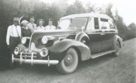
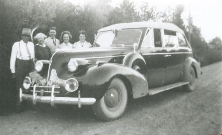
McKenzie family
https://search.heritageburnaby.ca/link/archivedescription37041
- Repository
- City of Burnaby Archives
- Date
- 1939 (date of original), copied 1992
- Collection/Fonds
- Burnaby Historical Society fonds
- Description Level
- Item
- Physical Description
- 1 photograph : b&w ; 7.9 x 12.7 cm print
- Scope and Content
- Photograph of the McKenzie family (Mr. and Mrs. McKenzie, Alex, Annie, and Elsie) with the car used by King George VI and Queen Elizabeth on their tour of Canada. The car is a McLaughlin-Buick (Canadian-built car) that was made especially for the Royal Tour.
- Repository
- City of Burnaby Archives
- Date
- 1939 (date of original), copied 1992
- Collection/Fonds
- Burnaby Historical Society fonds
- Subseries
- Burnaby Centennial Anthology subseries
- Physical Description
- 1 photograph : b&w ; 7.9 x 12.7 cm print
- Description Level
- Item
- Record No.
- 315-504
- Access Restriction
- No restrictions
- Reproduction Restriction
- No known restrictions
- Accession Number
- BHS1994-04
- Scope and Content
- Photograph of the McKenzie family (Mr. and Mrs. McKenzie, Alex, Annie, and Elsie) with the car used by King George VI and Queen Elizabeth on their tour of Canada. The car is a McLaughlin-Buick (Canadian-built car) that was made especially for the Royal Tour.
- Subjects
- Transportation - Automobiles
- Media Type
- Photograph
- Notes
- Title based on contents of photograph
Images
![Violet Eagles in the garden, [1939] (date of original), copied 1996 thumbnail](/media/hpo/_Data/_Archives_Images/_Unrestricted/316/331-006.jpg?width=280)
Violet Eagles in the garden
https://search.heritageburnaby.ca/link/archivedescription37188
- Repository
- City of Burnaby Archives
- Date
- [1939] (date of original), copied 1996
- Collection/Fonds
- Burnaby Historical Society fonds
- Description Level
- Item
- Physical Description
- 1 photograph : b&w ; 10 x 17 cm print
- Scope and Content
- Photograph of Violet Eagles standing in the garden at the Eagles Estate with a another woman and a child and a dog.
- Repository
- City of Burnaby Archives
- Date
- [1939] (date of original), copied 1996
- Collection/Fonds
- Burnaby Historical Society fonds
- Subseries
- Eagles family subseries
- Physical Description
- 1 photograph : b&w ; 10 x 17 cm print
- Description Level
- Item
- Record No.
- 331-006
- Access Restriction
- No restrictions
- Reproduction Restriction
- No known restrictions
- Accession Number
- BHS1996-21
- Scope and Content
- Photograph of Violet Eagles standing in the garden at the Eagles Estate with a another woman and a child and a dog.
- Subjects
- Geographic Features - Gardens
- Buildings - Residential - Houses
- Buildings - Heritage
- Animals - Dogs
- Names
- Eagles, Dr. Violet
- Media Type
- Photograph
- Notes
- Title based on contents of photograph
- Geographic Access
- Sperling Avenue
- Street Address
- 5655 Sperling Avenue
- Historic Neighbourhood
- Burnaby Lake (Historic Neighbourhood)
- Planning Study Area
- Morley-Buckingham Area
Images
![Violet Eagles in the garden, [1939] (date of original), copied 1996 thumbnail](/media/hpo/_Data/_Archives_Images/_Unrestricted/316/331-006.jpg)
![Eagles garden, [1939] (date of original), copied 1996 thumbnail](/media/hpo/_Data/_Archives_Images/_Unrestricted/316/331-008.jpg?width=280)
Eagles garden
https://search.heritageburnaby.ca/link/archivedescription37190
- Repository
- City of Burnaby Archives
- Date
- [1939] (date of original), copied 1996
- Collection/Fonds
- Burnaby Historical Society fonds
- Description Level
- Item
- Physical Description
- 1 photograph : b&w ; 10 x 17 cm print
- Scope and Content
- Photograph taken from a distance of two women standing the the Eagles' garden.
- Repository
- City of Burnaby Archives
- Date
- [1939] (date of original), copied 1996
- Collection/Fonds
- Burnaby Historical Society fonds
- Subseries
- Eagles family subseries
- Physical Description
- 1 photograph : b&w ; 10 x 17 cm print
- Description Level
- Item
- Record No.
- 331-008
- Access Restriction
- No restrictions
- Reproduction Restriction
- No known restrictions
- Accession Number
- BHS1996-21
- Scope and Content
- Photograph taken from a distance of two women standing the the Eagles' garden.
- Subjects
- Geographic Features - Gardens
- Media Type
- Photograph
- Notes
- Title based on contents of photograph
- Geographic Access
- Sperling Avenue
- Street Address
- 5655 Sperling Avenue
- Historic Neighbourhood
- Burnaby Lake (Historic Neighbourhood)
- Planning Study Area
- Morley-Buckingham Area
Images
![Eagles garden, [1939] (date of original), copied 1996 thumbnail](/media/hpo/_Data/_Archives_Images/_Unrestricted/316/331-008.jpg)
![Eagles house and landscaping, [1939] (date of original), copied 1996 thumbnail](/media/hpo/_Data/_Archives_Images/_Unrestricted/316/331-010.jpg?width=280)
Eagles house and landscaping
https://search.heritageburnaby.ca/link/archivedescription37192
- Repository
- City of Burnaby Archives
- Date
- [1939] (date of original), copied 1996
- Collection/Fonds
- Burnaby Historical Society fonds
- Description Level
- Item
- Physical Description
- 1 photograph : b&w ; 10 x 17 cm print
- Scope and Content
- Photograph of Drs. Blythe and Violet Eagles standing outside of their house with two other couples.
- Repository
- City of Burnaby Archives
- Date
- [1939] (date of original), copied 1996
- Collection/Fonds
- Burnaby Historical Society fonds
- Subseries
- Eagles family subseries
- Physical Description
- 1 photograph : b&w ; 10 x 17 cm print
- Description Level
- Item
- Record No.
- 331-010
- Access Restriction
- No restrictions
- Reproduction Restriction
- No known restrictions
- Accession Number
- BHS1996-21
- Scope and Content
- Photograph of Drs. Blythe and Violet Eagles standing outside of their house with two other couples.
- Media Type
- Photograph
- Notes
- Title based on contents of photograph
- Geographic Access
- Sperling Avenue
- Street Address
- 5655 Sperling Avenue
- Historic Neighbourhood
- Burnaby Lake (Historic Neighbourhood)
- Planning Study Area
- Morley-Buckingham Area
Images
![Eagles house and landscaping, [1939] (date of original), copied 1996 thumbnail](/media/hpo/_Data/_Archives_Images/_Unrestricted/316/331-010.jpg)
![Jack Kask at Kask Filling Station, [1939 or 1940] (date of original), copied 1991 thumbnail](/media/hpo/_Data/_Archives_Images/_Unrestricted/370/370-003.jpg?width=280)
Jack Kask at Kask Filling Station
https://search.heritageburnaby.ca/link/archivedescription37415
- Repository
- City of Burnaby Archives
- Date
- [1939 or 1940] (date of original), copied 1991
- Collection/Fonds
- Burnaby Historical Society fonds
- Description Level
- Item
- Physical Description
- 1 photograph : b&w ; 4.8 x 2.9 cm print on contact sheet 20.2 x 25.4 cm
- Scope and Content
- Photograph of Jack Kask at 10 years old, standing in front of Kask Filling Station at Kask Camp, Barnet Road. He is standing beside a "Signal" gas pump.
- Repository
- City of Burnaby Archives
- Date
- [1939 or 1940] (date of original), copied 1991
- Collection/Fonds
- Burnaby Historical Society fonds
- Subseries
- Burnaby Image Bank subseries
- Physical Description
- 1 photograph : b&w ; 4.8 x 2.9 cm print on contact sheet 20.2 x 25.4 cm
- Description Level
- Item
- Record No.
- 370-003
- Access Restriction
- No restrictions
- Reproduction Restriction
- No known restrictions
- Accession Number
- BHS1999-03
- Scope and Content
- Photograph of Jack Kask at 10 years old, standing in front of Kask Filling Station at Kask Camp, Barnet Road. He is standing beside a "Signal" gas pump.
- Names
- Kask, John "Jack"
- Media Type
- Photograph
- Notes
- Title based on contents of photograph
- 1 b&w copy negative accompanying
- Geographic Access
- Barnet Road
- Street Address
- 7501 Barnet Road
- Historic Neighbourhood
- Barnet (Historic Neighbourhood)
- Planning Study Area
- Burnaby Mountain Area
Images
![Jack Kask at Kask Filling Station, [1939 or 1940] (date of original), copied 1991 thumbnail](/media/hpo/_Data/_Archives_Images/_Unrestricted/370/370-003.jpg)
![Kask Gas Truck, [ca. 1939] (date of original), copied 1991 thumbnail](/media/hpo/_Data/_Archives_Images/_Unrestricted/370/370-004.jpg?width=280)
Kask Gas Truck
https://search.heritageburnaby.ca/link/archivedescription37416
- Repository
- City of Burnaby Archives
- Date
- [ca. 1939] (date of original), copied 1991
- Collection/Fonds
- Burnaby Historical Society fonds
- Description Level
- Item
- Physical Description
- 1 photograph : b&w ; 4.9 x 2.9 cm print on contact sheet 20.2 x 25.4 cm
- Scope and Content
- Photograph of one of William "Bill" Kask, Sr.'s, first gas trucks (reading "Signal" on the side). Four men are sitting or standing on the truck. William "Bill" Kask, Jr., is on the left.
- Repository
- City of Burnaby Archives
- Date
- [ca. 1939] (date of original), copied 1991
- Collection/Fonds
- Burnaby Historical Society fonds
- Subseries
- Burnaby Image Bank subseries
- Physical Description
- 1 photograph : b&w ; 4.9 x 2.9 cm print on contact sheet 20.2 x 25.4 cm
- Description Level
- Item
- Record No.
- 370-004
- Access Restriction
- No restrictions
- Reproduction Restriction
- No restrictions
- Accession Number
- BHS1999-03
- Scope and Content
- Photograph of one of William "Bill" Kask, Sr.'s, first gas trucks (reading "Signal" on the side). Four men are sitting or standing on the truck. William "Bill" Kask, Jr., is on the left.
- Subjects
- Transportation - Trucks
- Media Type
- Photograph
- Notes
- Title based on contents of photograph
- 1 b&w copy negative accompanying
- Geographic Access
- Barnet Road
- Street Address
- 7501 Barnet Road
- Historic Neighbourhood
- Barnet (Historic Neighbourhood)
- Planning Study Area
- Burnaby Mountain Area
Images
![Kask Gas Truck, [ca. 1939] (date of original), copied 1991 thumbnail](/media/hpo/_Data/_Archives_Images/_Unrestricted/370/370-004.jpg)
![North Burnaby pick-up soccer team, [1939] (date of original), copied 1991 thumbnail](/media/hpo/_Data/_Archives_Images/_Unrestricted/370/370-183.jpg?width=280)
North Burnaby pick-up soccer team
https://search.heritageburnaby.ca/link/archivedescription37595
- Repository
- City of Burnaby Archives
- Date
- [1939] (date of original), copied 1991
- Collection/Fonds
- Burnaby Historical Society fonds
- Description Level
- Item
- Physical Description
- 1 photograph : b&w ; 3.1 x 4.7 cm print on contact sheet 20.2 x 25.3 cm
- Scope and Content
- Photograph of a North Burnaby pick-up soccer team at Confederation Park.
- Repository
- City of Burnaby Archives
- Date
- [1939] (date of original), copied 1991
- Collection/Fonds
- Burnaby Historical Society fonds
- Subseries
- Burnaby Image Bank subseries
- Physical Description
- 1 photograph : b&w ; 3.1 x 4.7 cm print on contact sheet 20.2 x 25.3 cm
- Description Level
- Item
- Record No.
- 370-183
- Access Restriction
- No restrictions
- Reproduction Restriction
- No known restrictions
- Accession Number
- BHS1999-03
- Scope and Content
- Photograph of a North Burnaby pick-up soccer team at Confederation Park.
- Subjects
- Sports - Soccer
- Sports - Team Sports
- Media Type
- Photograph
- Notes
- Title based on contents of photograph
- 1 b&w copy negative accompanying
- Negative has a pink cast
- Geographic Access
- Confederation Park
- Willingdon Avenue
- Street Address
- 250 Willingdon Avenue
- Historic Neighbourhood
- Capitol Hill (Historic Neighbourhood)
- Planning Study Area
- Capitol Hill Area
Images
![North Burnaby pick-up soccer team, [1939] (date of original), copied 1991 thumbnail](/media/hpo/_Data/_Archives_Images/_Unrestricted/370/370-183.jpg)