Narrow Results By
Subject
- Advertising Medium - Signs and Signboards 1
- Agriculture - Farms 1
- Agriculture - Fruit and Berries 2
- Agriculture - Orchards 1
- Buildings - Civic - Hospitals 1
- Buildings - Civic - Museums 16
- Buildings - Commercial 1
- Buildings - Commercial - General Stores 4
- Buildings - Commercial - Hardware Stores 17
- Buildings - Commercial - Restaurants 1
- Buildings - Heritage 21
- Buildings - Industrial - Factories 5
![W.H. Lewis farm, [1900] thumbnail](/media/hpo/_Data/_Archives_Images/_Unrestricted/001/022-002.jpg?width=280)
W.H. Lewis farm
https://search.heritageburnaby.ca/link/archivedescription34499
- Repository
- City of Burnaby Archives
- Date
- [1900]
- Collection/Fonds
- Burnaby Historical Society fonds
- Description Level
- Item
- Physical Description
- 1 photograph : sepia ; 12.6 x 17.7 cm mounted on cardboard 14.2 x 19.3 cm
- Scope and Content
- Photograph of W.H. Lewis' fruit farm with a man, three women and five children kneeling in a strawberry field. "Pioneer Tales" identifies them as William Lewis (foreground), three of his children, and hired help. A house can be seen in the background. The Lewis house was located on 4th Street.
- Repository
- City of Burnaby Archives
- Date
- [1900]
- Collection/Fonds
- Burnaby Historical Society fonds
- Subseries
- Photographs subseries
- Physical Description
- 1 photograph : sepia ; 12.6 x 17.7 cm mounted on cardboard 14.2 x 19.3 cm
- Description Level
- Item
- Record No.
- 022-002
- Access Restriction
- No restrictions
- Reproduction Restriction
- No known restrictions
- Accession Number
- BHS2007-04
- Scope and Content
- Photograph of W.H. Lewis' fruit farm with a man, three women and five children kneeling in a strawberry field. "Pioneer Tales" identifies them as William Lewis (foreground), three of his children, and hired help. A house can be seen in the background. The Lewis house was located on 4th Street.
- Media Type
- Photograph
- Photographer
- Cooksley, William Thomas
- Notes
- Title based on contents of photograph
- Annotation at bottom of photograph reads, "W.H. Lewis' Fruit Farm, Burnaby, B.C."
- Geographic Access
- 4th Street
- 18th Avenue
- Historic Neighbourhood
- East Burnaby (Historic Neighbourhood)
- Planning Study Area
- Second Street Area
Images
![W.H. Lewis farm, [1900] thumbnail](/media/hpo/_Data/_Archives_Images/_Unrestricted/001/022-002.jpg)

Lewis family
https://search.heritageburnaby.ca/link/archivedescription35698
- Repository
- City of Burnaby Archives
- Date
- 1903 (date of original), copied 1986
- Collection/Fonds
- Burnaby Historical Society fonds
- Description Level
- Item
- Physical Description
- 1 photograph : b&w ; 12.7 x 17.8 cm print
- Scope and Content
- Photograph of (left to right) Lillie Lewis (sister - later Lillie Porter), William Lewis (father), Evelyn Lewis (sister), and Ernest Lewis (brother) picking strawberries at the side of their house. Note the apple trees all around. The other people in the picture are unidentified hired help.
- Repository
- City of Burnaby Archives
- Date
- 1903 (date of original), copied 1986
- Collection/Fonds
- Burnaby Historical Society fonds
- Subseries
- Pioneer Tales subseries
- Physical Description
- 1 photograph : b&w ; 12.7 x 17.8 cm print
- Description Level
- Item
- Record No.
- 204-556
- Access Restriction
- No restrictions
- Reproduction Restriction
- No known restrictions
- Accession Number
- BHS1988-03
- Scope and Content
- Photograph of (left to right) Lillie Lewis (sister - later Lillie Porter), William Lewis (father), Evelyn Lewis (sister), and Ernest Lewis (brother) picking strawberries at the side of their house. Note the apple trees all around. The other people in the picture are unidentified hired help.
- Subjects
- Occupations - Agricultural Labourers
- Agriculture - Fruit and Berries
- Occupations - Farmers
- Buildings - Residential - Houses
- Media Type
- Photograph
- Photographer
- Cooksley, William Thomas
- Notes
- Title based on contents of photograph
- Geographic Access
- 4th Street
- 18th Avenue
- Historic Neighbourhood
- East Burnaby (Historic Neighbourhood)
- Planning Study Area
- Second Street Area
Images

![Lewis family, [1904] (date of original), copied 1985 thumbnail](/media/hpo/_Data/_Archives_Images/_Unrestricted/126/140-002.jpg?width=280)
Lewis family
https://search.heritageburnaby.ca/link/archivedescription34821
- Repository
- City of Burnaby Archives
- Date
- [1904] (date of original), copied 1985
- Collection/Fonds
- Burnaby Historical Society fonds
- Description Level
- Item
- Physical Description
- 1 photograph : b&w ; 8.8 x 12.5 cm print
- Scope and Content
- Photograph of Lewis family in front their house at 4th Street and 18th Avenue. "Pioneer Tales" identifies them as, left to right, Emma Lewis (mother) and children: Evelyn, Lizzie, Lillie (later, Lillie Porter), Albert, and Ernest. The description in the accession file reads "Greenhouse, root house…
- Repository
- City of Burnaby Archives
- Date
- [1904] (date of original), copied 1985
- Collection/Fonds
- Burnaby Historical Society fonds
- Subseries
- Lewis family subseries
- Physical Description
- 1 photograph : b&w ; 8.8 x 12.5 cm print
- Description Level
- Item
- Record No.
- 140-002
- Access Restriction
- No restrictions
- Reproduction Restriction
- No known restrictions
- Accession Number
- BHS1985-10
- Scope and Content
- Photograph of Lewis family in front their house at 4th Street and 18th Avenue. "Pioneer Tales" identifies them as, left to right, Emma Lewis (mother) and children: Evelyn, Lizzie, Lillie (later, Lillie Porter), Albert, and Ernest. The description in the accession file reads "Greenhouse, root house, cherry tree."
- Media Type
- Photograph
- Notes
- Title based on contents of photograph
- Geographic Access
- 4th Street
- 18th Avenue
- Historic Neighbourhood
- East Burnaby (Historic Neighbourhood)
- Planning Study Area
- Second Street Area
Images
![Lewis family, [1904] (date of original), copied 1985 thumbnail](/media/hpo/_Data/_Archives_Images/_Unrestricted/126/140-002.jpg)
![Lewis family, [1904] (date of original), copied 1985 thumbnail](/media/hpo/_Data/_Archives_Images/_Unrestricted/126/140-003.jpg?width=280)
Lewis family
https://search.heritageburnaby.ca/link/archivedescription34822
- Repository
- City of Burnaby Archives
- Date
- [1904] (date of original), copied 1985
- Collection/Fonds
- Burnaby Historical Society fonds
- Description Level
- Item
- Physical Description
- 1 photograph : b&w ; 8.8 x 12.5 cm print
- Scope and Content
- Photograph of the Lewis family in the orchard of their home at 4th Street and 18th Avenue. "Pioneer Tales" identifies them as, left to right, Emma Lewis (mother) and children: Lillie (later, Lillie Porter), Evelyn, Ernest, Lizzie, and Albert.
- Repository
- City of Burnaby Archives
- Date
- [1904] (date of original), copied 1985
- Collection/Fonds
- Burnaby Historical Society fonds
- Subseries
- Lewis family subseries
- Physical Description
- 1 photograph : b&w ; 8.8 x 12.5 cm print
- Description Level
- Item
- Record No.
- 140-003
- Access Restriction
- No restrictions
- Reproduction Restriction
- No known restrictions
- Accession Number
- BHS1985-10
- Scope and Content
- Photograph of the Lewis family in the orchard of their home at 4th Street and 18th Avenue. "Pioneer Tales" identifies them as, left to right, Emma Lewis (mother) and children: Lillie (later, Lillie Porter), Evelyn, Ernest, Lizzie, and Albert.
- Subjects
- Agriculture - Orchards
- Media Type
- Photograph
- Notes
- Title based on contents of photograph
- Geographic Access
- 4th Street
- 18th Avenue
- Historic Neighbourhood
- East Burnaby (Historic Neighbourhood)
- Planning Study Area
- Second Street Area
Images
![Lewis family, [1904] (date of original), copied 1985 thumbnail](/media/hpo/_Data/_Archives_Images/_Unrestricted/126/140-003.jpg)

Lewis family
https://search.heritageburnaby.ca/link/archivedescription35699
- Repository
- City of Burnaby Archives
- Date
- 1904 (date of original), copied 1986
- Collection/Fonds
- Burnaby Historical Society fonds
- Description Level
- Item
- Physical Description
- 1 photograph : b&w ; 12.7 x 17.8 cm print
- Scope and Content
- Photograph of the Lewis family. Left to right: Mrs. Emma Lewis (mother) and children Evelyn, Lizzie, Lillie (later, Lillie Porter), Albert and Ernest in front of their home. Note the cherry trees, mostly Queen Anne reds.
- Repository
- City of Burnaby Archives
- Date
- 1904 (date of original), copied 1986
- Collection/Fonds
- Burnaby Historical Society fonds
- Subseries
- Pioneer Tales subseries
- Physical Description
- 1 photograph : b&w ; 12.7 x 17.8 cm print
- Description Level
- Item
- Record No.
- 204-557
- Access Restriction
- No restrictions
- Reproduction Restriction
- No known restrictions
- Accession Number
- BHS1988-03
- Scope and Content
- Photograph of the Lewis family. Left to right: Mrs. Emma Lewis (mother) and children Evelyn, Lizzie, Lillie (later, Lillie Porter), Albert and Ernest in front of their home. Note the cherry trees, mostly Queen Anne reds.
- Subjects
- Buildings - Residential - Houses
- Media Type
- Photograph
- Notes
- Title based on contents of photograph
- Geographic Access
- 4th Street
- 18th Avenue
- Historic Neighbourhood
- East Burnaby (Historic Neighbourhood)
- Planning Study Area
- Second Street Area
Images

![George Leaf General Store, [1905] thumbnail](/media/hpo/_Data/_Archives_Images/_Unrestricted/204/204-216.jpg?width=280)
George Leaf General Store
https://search.heritageburnaby.ca/link/archivedescription35359
- Repository
- City of Burnaby Archives
- Date
- [1905]
- Collection/Fonds
- Burnaby Historical Society fonds
- Description Level
- Item
- Physical Description
- 1 photograph : b&w ; 12.7 x 17.8 cm print
- Scope and Content
- Photograph of the George Leaf general store, at 7745 6th Street. Identified are: (left to right) Andy Johnston, Bill Bailey, Harry Archibald, Ed Harris, Bob Burgess (George Leaf's half-brother), and Tom Breen. All were staff members of the store, which was one of the earliest businesses in Burnaby…
- Repository
- City of Burnaby Archives
- Date
- [1905]
- Collection/Fonds
- Burnaby Historical Society fonds
- Subseries
- Pioneer Tales subseries
- Physical Description
- 1 photograph : b&w ; 12.7 x 17.8 cm print
- Description Level
- Item
- Record No.
- 204-216
- Access Restriction
- No restrictions
- Reproduction Restriction
- No known restrictions
- Accession Number
- BHS1988-03
- Scope and Content
- Photograph of the George Leaf general store, at 7745 6th Street. Identified are: (left to right) Andy Johnston, Bill Bailey, Harry Archibald, Ed Harris, Bob Burgess (George Leaf's half-brother), and Tom Breen. All were staff members of the store, which was one of the earliest businesses in Burnaby. In the reflection of the store window at the right is the streetcar station on the opposite side of the street. This store burned down in 1913, and a second one was built on Keefer Road (now McKay Avenue).
- Names
- Archibald, Harry
- Bailey, Bill
- Breen, Tom
- Burgess, Bob
- George Leaf General Store
- Harris, Ed
- Johnston, Andy
- Media Type
- Photograph
- Notes
- Title based on contents of photograph
- Geographic Access
- 6th Street
- Street Address
- 7745 6th Street
- Historic Neighbourhood
- East Burnaby (Historic Neighbourhood)
- Planning Study Area
- Edmonds Area
Images
![George Leaf General Store, [1905] thumbnail](/media/hpo/_Data/_Archives_Images/_Unrestricted/204/204-216.jpg)
![George Leaf General Store, [1905] (date of original), copied 1986 thumbnail](/media/hpo/_Data/_Archives_Images/_Unrestricted/204/204-217.jpg?width=280)
George Leaf General Store
https://search.heritageburnaby.ca/link/archivedescription35360
- Repository
- City of Burnaby Archives
- Date
- [1905] (date of original), copied 1986
- Collection/Fonds
- Burnaby Historical Society fonds
- Description Level
- Item
- Physical Description
- 1 photograph : b&w ; 12.7 x 17.8 cm print
- Scope and Content
- Photograph of the inside of the George Leaf General Store and post office at 12th Avenue and 6th Street, 7745 6th Street. This was one of the earliest businesses in Burnaby. This store burned down in 1913, and a second one was built on Keefer Road (now McKay Avenue).
- Repository
- City of Burnaby Archives
- Date
- [1905] (date of original), copied 1986
- Collection/Fonds
- Burnaby Historical Society fonds
- Subseries
- Pioneer Tales subseries
- Physical Description
- 1 photograph : b&w ; 12.7 x 17.8 cm print
- Description Level
- Item
- Record No.
- 204-217
- Access Restriction
- No restrictions
- Reproduction Restriction
- No known restrictions
- Accession Number
- BHS1988-03
- Scope and Content
- Photograph of the inside of the George Leaf General Store and post office at 12th Avenue and 6th Street, 7745 6th Street. This was one of the earliest businesses in Burnaby. This store burned down in 1913, and a second one was built on Keefer Road (now McKay Avenue).
- Media Type
- Photograph
- Notes
- Title based on contents of photograph
- Geographic Access
- 6th Street
- Street Address
- 7745 6th Street
- Historic Neighbourhood
- East Burnaby (Historic Neighbourhood)
- Planning Study Area
- Edmonds Area
Images
![George Leaf General Store, [1905] (date of original), copied 1986 thumbnail](/media/hpo/_Data/_Archives_Images/_Unrestricted/204/204-217.jpg)
![George Leaf General Store, [1905] (date of original), copied 1986 thumbnail](/media/hpo/_Data/_Archives_Images/_Unrestricted/204/204-218.jpg?width=280)
George Leaf General Store
https://search.heritageburnaby.ca/link/archivedescription35361
- Repository
- City of Burnaby Archives
- Date
- [1905] (date of original), copied 1986
- Collection/Fonds
- Burnaby Historical Society fonds
- Description Level
- Item
- Physical Description
- 1 photograph : b&w ; 12.7 x 17.8 cm print
- Scope and Content
- Photograph of the inside of the George Leaf General Store and post office at 12th Avenue and 6th Street, 7745 6th Street. This was one of the earliest businesses in Burnaby. This store burned down in 1913, and a second one was built on Keefer Road .
- Repository
- City of Burnaby Archives
- Date
- [1905] (date of original), copied 1986
- Collection/Fonds
- Burnaby Historical Society fonds
- Subseries
- Pioneer Tales subseries
- Physical Description
- 1 photograph : b&w ; 12.7 x 17.8 cm print
- Description Level
- Item
- Record No.
- 204-218
- Access Restriction
- No restrictions
- Reproduction Restriction
- No known restrictions
- Accession Number
- BHS1988-03
- Scope and Content
- Photograph of the inside of the George Leaf General Store and post office at 12th Avenue and 6th Street, 7745 6th Street. This was one of the earliest businesses in Burnaby. This store burned down in 1913, and a second one was built on Keefer Road .
- Media Type
- Photograph
- Notes
- Title based on contents of photograph
- Geographic Access
- 6th Street
- Street Address
- 7745 6th Street
- Historic Neighbourhood
- East Burnaby (Historic Neighbourhood)
- Planning Study Area
- Edmonds Area
Images
![George Leaf General Store, [1905] (date of original), copied 1986 thumbnail](/media/hpo/_Data/_Archives_Images/_Unrestricted/204/204-218.jpg)
![Tramline tracks, [1905] thumbnail](/media/hpo/_Data/_BVM_Images/1990/199500100001.jpg?width=280)
Tramline tracks
https://search.heritageburnaby.ca/link/museumdescription3361
- Repository
- Burnaby Village Museum
- Date
- [1905]
- Collection/Fonds
- Burnaby Village Museum Photograph collection
- Description Level
- Item
- Physical Description
- 1 photograph : b&w ; 15 x 25.5 cm print
- Scope and Content
- Photograph of a British Columbia Electric Railway Company tramline track on Sixth Street and Twelfth Avenue. George Leaf's General Store, located at 7745 Sixth Street is visible on the left and Cliff's Car Factory located at 7730 Sixth Street is visible on the right. George Leaf's store burned down…
- Repository
- Burnaby Village Museum
- Collection/Fonds
- Burnaby Village Museum Photograph collection
- Description Level
- Item
- Physical Description
- 1 photograph : b&w ; 15 x 25.5 cm print
- Scope and Content
- Photograph of a British Columbia Electric Railway Company tramline track on Sixth Street and Twelfth Avenue. George Leaf's General Store, located at 7745 Sixth Street is visible on the left and Cliff's Car Factory located at 7730 Sixth Street is visible on the right. George Leaf's store burned down in 1913. The Car factory was established in 1902 and sometime in the 1920s, it became James Brookes Woodworking Plant.
- Subjects
- Transportation - Electric Railroads
- Buildings - Commercial - General Stores
- Buildings - Industrial - Factories
- Geographic Access
- 6th Street
- 12th Avenue
- Street Address
- 7730 6th Street
- 7745 6th Street
- Accession Code
- BV995.10.1
- Access Restriction
- No restrictions
- Date
- [1905]
- Media Type
- Photograph
- Historic Neighbourhood
- East Burnaby (Historic Neighbourhood)
- Planning Study Area
- Edmonds Area
- Notes
- Title based on contents of photograph
Images
![Tramline tracks, [1905] thumbnail](/media/hpo/_Data/_BVM_Images/1990/199500100001.jpg)

Coldicutt House
https://search.heritageburnaby.ca/link/archivedescription34549
- Repository
- City of Burnaby Archives
- Date
- 1914
- Collection/Fonds
- Burnaby Historical Society fonds
- Description Level
- Item
- Physical Description
- 1 photograph : b&w ; 16.0 x 21.1 cm mounted on 25.1 x 30.1 cm cardboard
- Scope and Content
- Photograph of the exterior of the Coldicutt House at 7510 6th Street.
- Repository
- City of Burnaby Archives
- Date
- 1914
- Collection/Fonds
- Burnaby Historical Society fonds
- Subseries
- Photographs subseries
- Physical Description
- 1 photograph : b&w ; 16.0 x 21.1 cm mounted on 25.1 x 30.1 cm cardboard
- Description Level
- Item
- Record No.
- 044-009
- Access Restriction
- No restrictions
- Reproduction Restriction
- No known restrictions
- Accession Number
- BHS2007-04
- Scope and Content
- Photograph of the exterior of the Coldicutt House at 7510 6th Street.
- Media Type
- Photograph
- Notes
- Title based on contents of photograph
- Geographic Access
- 6th Street
- Street Address
- 7510 6th Street
- Historic Neighbourhood
- East Burnaby (Historic Neighbourhood)
- Planning Study Area
- Second Street Area
Images

Pollard family house
https://search.heritageburnaby.ca/link/archivedescription37355
- Repository
- City of Burnaby Archives
- Date
- 1914 (date of original), copied 1998
- Collection/Fonds
- Burnaby Historical Society fonds
- Description Level
- Item
- Physical Description
- 1 photograph : b&w ; 12.5 x 17.5 cm print
- Scope and Content
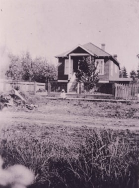
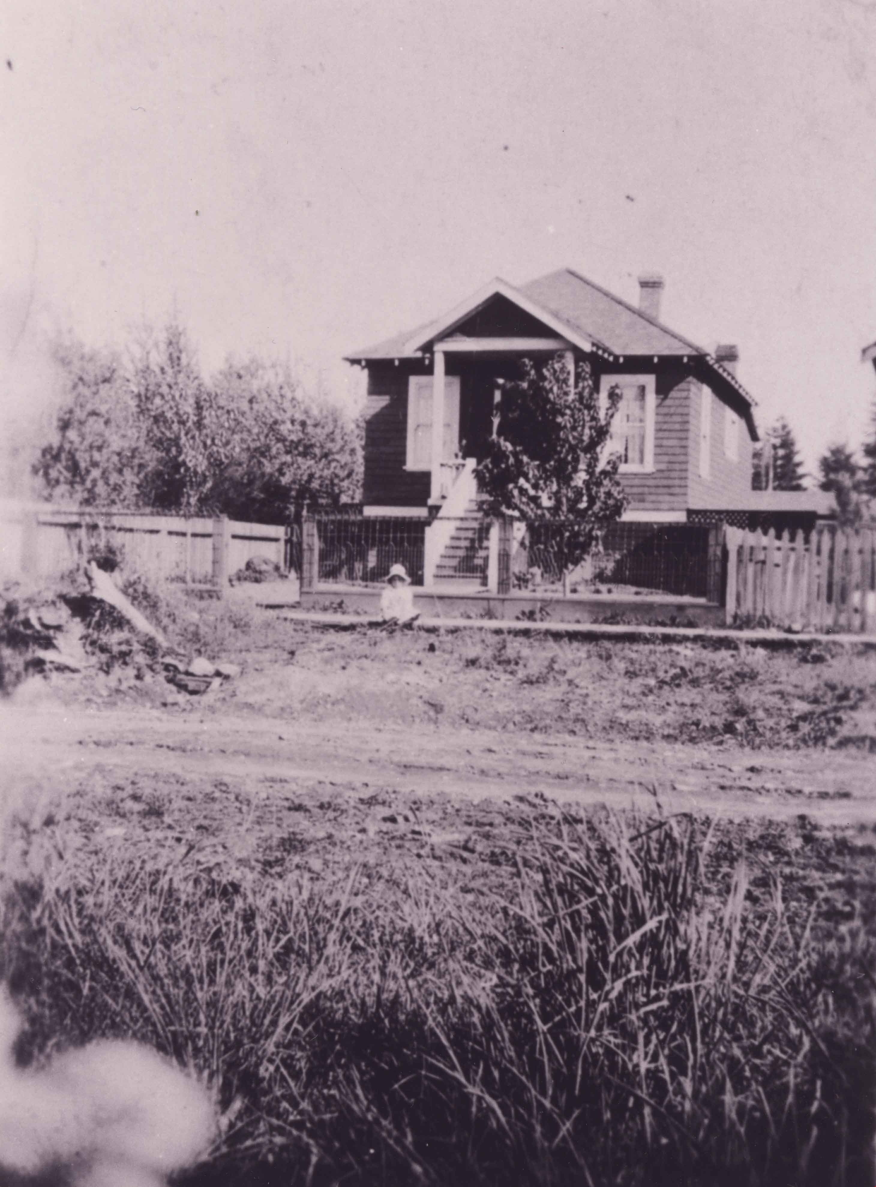
- Photograph of the Pollard family house at 17th Avenue near 4th Street in East Burnaby. Eldest daughter May is seated on the sidewalk in front of the house.
- Repository
- City of Burnaby Archives
- Date
- 1914 (date of original), copied 1998
- Collection/Fonds
- Burnaby Historical Society fonds
- Subseries
- Pollard family subseries
- Physical Description
- 1 photograph : b&w ; 12.5 x 17.5 cm print
- Description Level
- Item
- Record No.
- 359-001
- Access Restriction
- No restrictions
- Reproduction Restriction
- No known restrictions
- Accession Number
- BHS1998-09
- Scope and Content
- Photograph of the Pollard family house at 17th Avenue near 4th Street in East Burnaby. Eldest daughter May is seated on the sidewalk in front of the house.
- Subjects
- Buildings - Residential - Houses
- Names
- Pollard, May
- Media Type
- Photograph
- Notes
- Title based on contents of photograph
- Geographic Access
- 17th Avenue
- 4th Street
- Historic Neighbourhood
- East Burnaby (Historic Neighbourhood)
- Planning Study Area
- Second Street Area
Images
![Ramsey family, [1916] (date of original), copied [1999] thumbnail](/media/hpo/_Data/_Archives_Images/_Unrestricted/371/399-001.jpg?width=280)
Ramsey family
https://search.heritageburnaby.ca/link/archivedescription38301
- Repository
- City of Burnaby Archives
- Date
- [1916] (date of original), copied [1999]
- Collection/Fonds
- Burnaby Historical Society fonds
- Description Level
- Item
- Physical Description
- 1 photograph : b&w ; 20.2 x 25.3 cm print
- Scope and Content
- Photograph of seven members of the Ramsey family in the backyard of home at 12th Avenue and 4th Street. Identified are: standing (l to r): Eva Lillian Ramsey, Annie Ramsey (mother), and Queenie Ramsey. Seated (l to r): Dorothy Ramsey, Ernest Ramsey (twin to Dorothy), Gordon Ramsey and Jessie Ramse…
- Repository
- City of Burnaby Archives
- Date
- [1916] (date of original), copied [1999]
- Collection/Fonds
- Burnaby Historical Society fonds
- Subseries
- Ramsey family subseries
- Physical Description
- 1 photograph : b&w ; 20.2 x 25.3 cm print
- Description Level
- Item
- Record No.
- 399-001
- Access Restriction
- No restrictions
- Reproduction Restriction
- No known restrictions
- Accession Number
- BHS1999-19
- Scope and Content
- Photograph of seven members of the Ramsey family in the backyard of home at 12th Avenue and 4th Street. Identified are: standing (l to r): Eva Lillian Ramsey, Annie Ramsey (mother), and Queenie Ramsey. Seated (l to r): Dorothy Ramsey, Ernest Ramsey (twin to Dorothy), Gordon Ramsey and Jessie Ramsey.
- Names
- Ramsey, Annie
- Ramsey, Dorothy
- Ramsey, Ernest
- Ramsey, Eva Lillian
- Ramsey, Gordon
- Ramsey, Jessie
- Ramsey, Queenie
- Media Type
- Photograph
- Notes
- Title based on contents of photograph
- Geographic Access
- 4th Street
- 12th Avenue
- Historic Neighbourhood
- East Burnaby (Historic Neighbourhood)
- Planning Study Area
- Second Street Area
Images
![Ramsey family, [1916] (date of original), copied [1999] thumbnail](/media/hpo/_Data/_Archives_Images/_Unrestricted/371/399-001.jpg)

Brook family home
https://search.heritageburnaby.ca/link/archivedescription34803
- Repository
- City of Burnaby Archives
- Date
- 1919
- Collection/Fonds
- Burnaby Historical Society fonds
- Description Level
- Item
- Physical Description
- 1 photograph : b&w ; 6.9 x 11.4 cm
- Scope and Content
- Photograph of the exterior of the Brook family home at 7979 12th Avenue, East Burnaby. This house later became the Normanna Rest Home, 7725 4th Street.
- Repository
- City of Burnaby Archives
- Date
- 1919
- Collection/Fonds
- Burnaby Historical Society fonds
- Subseries
- Kathleen Moore family subseries
- Physical Description
- 1 photograph : b&w ; 6.9 x 11.4 cm
- Description Level
- Item
- Record No.
- 135-001
- Access Restriction
- No restrictions
- Reproduction Restriction
- No known restrictions
- Accession Number
- BHS1985-03
- Scope and Content
- Photograph of the exterior of the Brook family home at 7979 12th Avenue, East Burnaby. This house later became the Normanna Rest Home, 7725 4th Street.
- Names
- Normanna Rest Home
- Media Type
- Photograph
- Photographer
- Moore, Godfrey
- Notes
- Title based on contents of photograph
- The accession register notes that the photos in the this collection were taken by Kathleen Moore's father
- Geographic Access
- 4th Street
- Street Address
- 7725 4th Street
- Historic Neighbourhood
- East Burnaby (Historic Neighbourhood)
- Planning Study Area
- Second Street Area
Images


Brook family house
https://search.heritageburnaby.ca/link/archivedescription34804
- Repository
- City of Burnaby Archives
- Date
- 1919
- Collection/Fonds
- Burnaby Historical Society fonds
- Description Level
- Item
- Physical Description
- 1 photograph : b&w ; 6.9 x 11.3 cm
- Scope and Content
- Photograph of the exterior of the Brook family home at 7979 12th Avenue, East Burnaby. This house later became the Normanna Rest Home, 7725 4th Street.
- Repository
- City of Burnaby Archives
- Date
- 1919
- Collection/Fonds
- Burnaby Historical Society fonds
- Subseries
- Kathleen Moore family subseries
- Physical Description
- 1 photograph : b&w ; 6.9 x 11.3 cm
- Description Level
- Item
- Record No.
- 135-002
- Access Restriction
- No restrictions
- Reproduction Restriction
- No known restrictions
- Accession Number
- BHS1985-03
- Scope and Content
- Photograph of the exterior of the Brook family home at 7979 12th Avenue, East Burnaby. This house later became the Normanna Rest Home, 7725 4th Street.
- Names
- Normanna Rest Home
- Media Type
- Photograph
- Photographer
- Moore, Godfrey
- Notes
- Title based on contents of photograph
- The accession register notes that the photos in the this collection were taken by Kathleen Moore's father
- Geographic Access
- 4th Street
- Street Address
- 7725 4th Street
- Historic Neighbourhood
- Edmonds (Historic Neighbourhood)
- Planning Study Area
- Second Street Area
Images

![Brookes family home, [1920] (date of original), copied 1986 thumbnail](/media/hpo/_Data/_Archives_Images/_Unrestricted/204/204-102.jpg?width=280)
Brookes family home
https://search.heritageburnaby.ca/link/archivedescription35245
- Repository
- City of Burnaby Archives
- Date
- [1920] (date of original), copied 1986
- Collection/Fonds
- Burnaby Historical Society fonds
- Description Level
- Item
- Physical Description
- 1 photograph : b&w ; 12.7 x 17.8 cm print
- Scope and Content
- Photograph of the Brookes family home at 441 12th Avenue (later renumbered 7979 12th Avenue), at the corner of 4th Street in East Burnaby. The Brookes family, headed by James Brookes, moved into this house in 1917. The house was later cut in two and moved to another part of the lot, becoming a gard…
- Repository
- City of Burnaby Archives
- Date
- [1920] (date of original), copied 1986
- Collection/Fonds
- Burnaby Historical Society fonds
- Subseries
- Pioneer Tales subseries
- Physical Description
- 1 photograph : b&w ; 12.7 x 17.8 cm print
- Description Level
- Item
- Record No.
- 204-102
- Access Restriction
- No restrictions
- Reproduction Restriction
- No known restrictions
- Accession Number
- BHS1988-03
- Scope and Content
- Photograph of the Brookes family home at 441 12th Avenue (later renumbered 7979 12th Avenue), at the corner of 4th Street in East Burnaby. The Brookes family, headed by James Brookes, moved into this house in 1917. The house was later cut in two and moved to another part of the lot, becoming a gardener's house in 1927 when "Normanna" was built. Note the greenhouse in front of the house. This house was built by Burnaby's first Reeve, Charles Shaw, and is now a designated heritage site at 7725 4th Street.
- Media Type
- Photograph
- Notes
- Title based on contents of photograph
- Geographic Access
- 4th Street
- Street Address
- 7725 4th Street
- Historic Neighbourhood
- East Burnaby (Historic Neighbourhood)
- Planning Study Area
- Second Street Area
Images
![Brookes family home, [1920] (date of original), copied 1986 thumbnail](/media/hpo/_Data/_Archives_Images/_Unrestricted/204/204-102.jpg)
![Woodworking Plant, [192-] (date of original), copied 1986 thumbnail](/media/hpo/_Data/_Archives_Images/_Unrestricted/204/204-106.jpg?width=280)
Woodworking Plant
https://search.heritageburnaby.ca/link/archivedescription35249
- Repository
- City of Burnaby Archives
- Date
- [192-] (date of original), copied 1986
- Collection/Fonds
- Burnaby Historical Society fonds
- Description Level
- Item
- Physical Description
- 1 photograph : b&w ; 12.7 x 17.8 cm print
- Scope and Content
- Photograph of James Brookes Woodworking Plant located at 7730 6th Street. This site has also served as Cliff's Can Factory and Western Canadian Can Factory. Note the spur street car line (no. 2) where B.C. Electric Railway freight cars could load and unload.
- Repository
- City of Burnaby Archives
- Date
- [192-] (date of original), copied 1986
- Collection/Fonds
- Burnaby Historical Society fonds
- Subseries
- Pioneer Tales subseries
- Physical Description
- 1 photograph : b&w ; 12.7 x 17.8 cm print
- Description Level
- Item
- Record No.
- 204-106
- Access Restriction
- No restrictions
- Reproduction Restriction
- No known restrictions
- Accession Number
- BHS1988-03
- Scope and Content
- Photograph of James Brookes Woodworking Plant located at 7730 6th Street. This site has also served as Cliff's Can Factory and Western Canadian Can Factory. Note the spur street car line (no. 2) where B.C. Electric Railway freight cars could load and unload.
- Subjects
- Buildings - Industrial - Factories
- Media Type
- Photograph
- Notes
- Title based on contents of photograph
- Geographic Access
- 6th Street
- Street Address
- 7730 6th Street
- Historic Neighbourhood
- East Burnaby (Historic Neighbourhood)
- Planning Study Area
- Second Street Area
Images
![Woodworking Plant, [192-] (date of original), copied 1986 thumbnail](/media/hpo/_Data/_Archives_Images/_Unrestricted/204/204-106.jpg)
![Woodworking Plant, [192-] (date of original), copied 1986 thumbnail](/media/hpo/_Data/_Archives_Images/_Unrestricted/204/204-107.jpg?width=280)
Woodworking Plant
https://search.heritageburnaby.ca/link/archivedescription35250
- Repository
- City of Burnaby Archives
- Date
- [192-] (date of original), copied 1986
- Collection/Fonds
- Burnaby Historical Society fonds
- Description Level
- Item
- Physical Description
- 1 photograph : b&w ; 12.7 x 17.8 cm print
- Scope and Content
- Photograph of James Brookes Woodworking Plant, located at 7730 6th Street, taken from 13th Avenue. This site has also served as Cliff's Can Factory and Western Canadian Can Factory.
- Repository
- City of Burnaby Archives
- Date
- [192-] (date of original), copied 1986
- Collection/Fonds
- Burnaby Historical Society fonds
- Subseries
- Pioneer Tales subseries
- Physical Description
- 1 photograph : b&w ; 12.7 x 17.8 cm print
- Description Level
- Item
- Record No.
- 204-107
- Access Restriction
- No restrictions
- Reproduction Restriction
- No known restrictions
- Accession Number
- BHS1988-03
- Scope and Content
- Photograph of James Brookes Woodworking Plant, located at 7730 6th Street, taken from 13th Avenue. This site has also served as Cliff's Can Factory and Western Canadian Can Factory.
- Subjects
- Buildings - Industrial - Factories
- Media Type
- Photograph
- Notes
- Title based on contents of photograph
- Geographic Access
- 6th Street
- Street Address
- 7730 6th Street
- Historic Neighbourhood
- East Burnaby (Historic Neighbourhood)
- Planning Study Area
- Second Street Area
Images
![Woodworking Plant, [192-] (date of original), copied 1986 thumbnail](/media/hpo/_Data/_Archives_Images/_Unrestricted/204/204-107.jpg)
![Woodworking Plant, [192-] (date of original), copied 1986 thumbnail](/media/hpo/_Data/_Archives_Images/_Unrestricted/204/204-108.jpg?width=280)
Woodworking Plant
https://search.heritageburnaby.ca/link/archivedescription35251
- Repository
- City of Burnaby Archives
- Date
- [192-] (date of original), copied 1986
- Collection/Fonds
- Burnaby Historical Society fonds
- Description Level
- Item
- Physical Description
- 1 photograph : b&w ; 12.7 x 17.8 cm print
- Scope and Content
- Photograph of James Brookes Woodworking Plant, located at 7730 6th Street, taken from 6th Street. It was an East Burnaby landmark, established in 1902 as a can company by Edwin Cliff. This site has also served as Cliff's Can Factory and Western Canadian Can Factory.
- Repository
- City of Burnaby Archives
- Date
- [192-] (date of original), copied 1986
- Collection/Fonds
- Burnaby Historical Society fonds
- Subseries
- Pioneer Tales subseries
- Physical Description
- 1 photograph : b&w ; 12.7 x 17.8 cm print
- Description Level
- Item
- Record No.
- 204-108
- Access Restriction
- No restrictions
- Reproduction Restriction
- No known restrictions
- Accession Number
- BHS1988-03
- Scope and Content
- Photograph of James Brookes Woodworking Plant, located at 7730 6th Street, taken from 6th Street. It was an East Burnaby landmark, established in 1902 as a can company by Edwin Cliff. This site has also served as Cliff's Can Factory and Western Canadian Can Factory.
- Subjects
- Buildings - Industrial - Factories
- Media Type
- Photograph
- Notes
- Title based on contents of photograph
- Geographic Access
- 6th Street
- Street Address
- 7730 6th Street
- Historic Neighbourhood
- East Burnaby (Historic Neighbourhood)
- Planning Study Area
- Second Street Area
Images
![Woodworking Plant, [192-] (date of original), copied 1986 thumbnail](/media/hpo/_Data/_Archives_Images/_Unrestricted/204/204-108.jpg)
Pollard family car
https://search.heritageburnaby.ca/link/archivedescription37356
- Repository
- City of Burnaby Archives
- Date
- 1920 (date of original), copied 1998
- Collection/Fonds
- Burnaby Historical Society fonds
- Description Level
- Item
- Physical Description
- 1 photograph : b&w ; 12.8 x 17.5 cm print
- Scope and Content
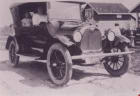
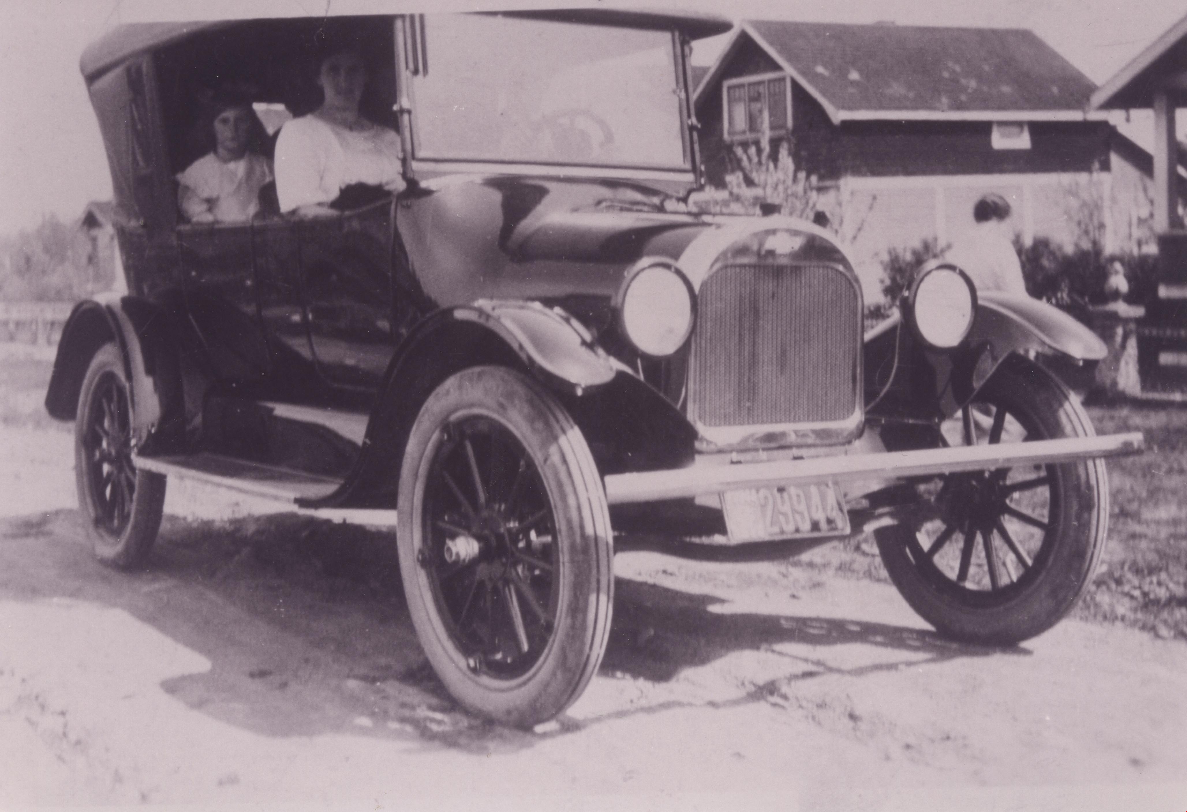
- Photograph of the Pollard family's first car, a 1920-1922 Chevrolet Four-ninety Touring Car (so named because of selling price of $490.00). Agnes Pollard is sitting on the passenger side at the front and her May is sitting in the back. This photograph was likely taken near the family home at 17th A…
- Repository
- City of Burnaby Archives
- Date
- 1920 (date of original), copied 1998
- Collection/Fonds
- Burnaby Historical Society fonds
- Subseries
- Pollard family subseries
- Physical Description
- 1 photograph : b&w ; 12.8 x 17.5 cm print
- Description Level
- Item
- Record No.
- 359-002
- Access Restriction
- No restrictions
- Reproduction Restriction
- No known restrictions
- Accession Number
- BHS1998-09
- Scope and Content
- Photograph of the Pollard family's first car, a 1920-1922 Chevrolet Four-ninety Touring Car (so named because of selling price of $490.00). Agnes Pollard is sitting on the passenger side at the front and her May is sitting in the back. This photograph was likely taken near the family home at 17th Avenue and 4th Street.
- Subjects
- Transportation - Automobiles
- Media Type
- Photograph
- Notes
- Title based on contents of photograph.
- Geographic Access
- 17th Avenue
- 4th Street
- Historic Neighbourhood
- East Burnaby (Historic Neighbourhood)
- Planning Study Area
- Second Street Area
Images
![James Brooke's house, [1925] thumbnail](/media/hpo/_Data/_BVM_Images/1984/1984_0056_0001_001.jpg?width=280)
James Brooke's house
https://search.heritageburnaby.ca/link/museumdescription278
- Repository
- Burnaby Village Museum
- Date
- [1925]
- Collection/Fonds
- Burnaby Village Museum Photograph collection
- Description Level
- Item
- Physical Description
- 1 photograph : b&w ; 6.9 x 11.5 cm
- Scope and Content
- Photograph of a two storey house with a basement built on a large lawn. There are flower beds on the lawn and a fence around the backyard. A neighboring house and the woods are visible in the background. According to the donor form, the photograph depicts James Brooke's house on 12th Avenue in Bu…
- Repository
- Burnaby Village Museum
- Collection/Fonds
- Burnaby Village Museum Photograph collection
- Description Level
- Item
- Physical Description
- 1 photograph : b&w ; 6.9 x 11.5 cm
- Scope and Content
- Photograph of a two storey house with a basement built on a large lawn. There are flower beds on the lawn and a fence around the backyard. A neighboring house and the woods are visible in the background. According to the donor form, the photograph depicts James Brooke's house on 12th Avenue in Burnaby, built by G. Moxham and Company. At the time of the donation, the house was owned by Normanna Rest Home. "
- Subjects
- Buildings - Residential - Houses
- Names
- Normanna Rest Home
- Geographic Access
- 4th Street
- Street Address
- 7725 4th Street
- Accession Code
- HV984.56.1
- Access Restriction
- No restrictions
- Reproduction Restriction
- No known restrictions
- Date
- [1925]
- Media Type
- Photograph
- Historic Neighbourhood
- East Burnaby (Historic Neighbourhood)
- Planning Study Area
- Second Street Area
- Scan Resolution
- 600
- Scan Date
- 2023-11-07
- Notes
- Title based on contents of photograph
- The annotation on verso of photo reads: "Home of James Brookes / (Normanna) now. / Built by G. Moxham & Co. / 1944 Sixth St. Burnaby. / built in early 20's - '22-'24?" Stamped on the back of the photo: "100.
Images
![James Brooke's house, [1925] thumbnail](/media/hpo/_Data/_BVM_Images/1984/1984_0056_0001_001.jpg)