Narrow Results By
Creator
- Arnold, Frank H. 1
- Banning, Kendall, 1879-1944 1
- Bingham, Alfred "Alf" 2
- Blake, Frederick "Fred" 2
- Bridgman's Studio Limited 3
- British Columbia Underwriters' Association 10
- Brown, Cice Chandler 1
- Bryce, Henry G.
- Bullen, Harry Elder 1
- Burnaby Village Museum 4
- Burnett & McGugan, Engineers and Surveyors
- Campbell Studios Limited 1
![East Burnaby United Church, [ca.1925] thumbnail](/media/hpo/_Data/_BVM_Cartographic_Material/2003/2003_0083_0054_001.jpg?width=280)
East Burnaby United Church
https://search.heritageburnaby.ca/link/museumdescription11932
- Repository
- Burnaby Village Museum
- Date
- [ca.1925]
- Collection/Fonds
- Ronald G. Scobbie collection
- Description Level
- Item
- Physical Description
- 1 plan : black ink and watercol. on paper ; 30.45 x 30.5 cm
- Scope and Content
- Item consists of a building insurance plan of "East Burnaby United Church / Lot 1 BK 2 south Part DL 28 GP 1 N.W.D.". Twelfth Avenue is identified to the north and Douglas Road to the west.
- Repository
- Burnaby Village Museum
- Collection/Fonds
- Ronald G. Scobbie collection
- Description Level
- Item
- Physical Description
- 1 plan : black ink and watercol. on paper ; 30.45 x 30.5 cm
- Material Details
- Scale 1 inch = 20 feet
- Scope and Content
- Item consists of a building insurance plan of "East Burnaby United Church / Lot 1 BK 2 south Part DL 28 GP 1 N.W.D.". Twelfth Avenue is identified to the north and Douglas Road to the west.
- Subjects
- Buildings - Religious - Churches
- Accession Code
- BV003.83.54
- Access Restriction
- No restrictions
- Reproduction Restriction
- No known restrictions
- Date
- [ca.1925]
- Media Type
- Cartographic Material
- Scan Resolution
- 600
- Scan Date
- 15-Jan-2021
- Scale
- 100
- Notes
- Transcribed title
- Note in pencil on verso reads: "East Burnaby United Church / Lot 1 BK 2 south Part DL 28 / 1" = 20' "
- Note in black ink on verso reads: "3704"
Images
![East Burnaby United Church, [ca.1925] thumbnail](/media/hpo/_Data/_BVM_Cartographic_Material/2003/2003_0083_0054_001.jpg)
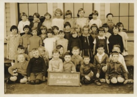
Kingsway West Division 14
https://search.heritageburnaby.ca/link/museumdescription1323
- Repository
- Burnaby Village Museum
- Date
- May 1927
- Collection/Fonds
- Burnaby Village Museum Photograph collection
- Description Level
- Item
- Physical Description
- 1 photograph : sepia ; 11.5 x 16 cm
- Scope and Content
- Photograph of Division 14 at Kingsway West School standing and sitting in five rows in front of the school building windows. Two boys sitting in the front row are holding up a chalk board which reads, "Kingsway West School/ Division 14." Standing in the top row (l to r) are; Audrey Browne, Joan Gol…
- Repository
- Burnaby Village Museum
- Collection/Fonds
- Burnaby Village Museum Photograph collection
- Description Level
- Item
- Physical Description
- 1 photograph : sepia ; 11.5 x 16 cm
- Scope and Content
- Photograph of Division 14 at Kingsway West School standing and sitting in five rows in front of the school building windows. Two boys sitting in the front row are holding up a chalk board which reads, "Kingsway West School/ Division 14." Standing in the top row (l to r) are; Audrey Browne, Joan Gold, Ida Wright, May Ford, Mabel Law, Dorothy Barber, Gladys Would and Isabel McFadyen. In the second row are; Betty Dermott, Maria Soda, Dorothy Guthrie, Pearl Rouse, Norma Moller, Marrion Hickenbotham, Priscilla Deane, Barbara Sleeth and Elsie Brown. In the third row are; Patricia Hodgson, Verna Crane, Gladys Nuttall, Muriel Iraine, Dorothy McKenzie, Doris Faulkner and Mildred Rutledge. Sitting in the fourth row are; James Murie, Bobby Shewan, Donald McKinnon, Howard Griffiths, Henry Nevin and Bobby Ferguson. In the front row are; Harvey Knorr, Alfred Younger, George Chamberlain (holding chalkboard), Ben Jacobson (holding chalkboard), Alex Walker and Garnet Eckard.
- Names
- Kingsway West School
- Browne, Audrey
- Gold, Joan
- Wright, Ida
- Ford, May
- Law, Mabel
- Barber, Dorothy
- Would, Gladys
- McFadyen, Isabel
- Dermott, Betty
- Soda, Maria
- Guthrie, Dorothy
- Rouse, Pearl
- Mollar, Norma
- Hickenbotham, Marion
- Deane, Priscilla
- Sleeth, Barbara
- Brown, Elsie
- Hodgson, Patricia
- Crane, Verna
- Nuttall, Gladys
- Iraine, Muriel
- McKenzie, Dorothy
- Faulkner, Doris
- Rutledge, Mildred
- Murie, James
- Shewan, Bobby
- McKinnon, Donald
- Griffiths, Howard
- Nevin, Henry
- Ferguson, Robert
- Knorr, Harvey
- Younger, Alfred
- Chamberlain, George
- Jacobson, Ben
- Walker, Alex
- Eckard, Garnet
- Geographic Access
- Kingsway
- Street Address
- 4800 Kingsway
- Accession Code
- BV999.2.11
- Access Restriction
- No restrictions
- Reproduction Restriction
- May be restricted by third party rights
- Date
- May 1927
- Media Type
- Photograph
- Historic Neighbourhood
- Central Park (Historic Neighbourhood)
- Planning Study Area
- Maywood Area
- Scan Resolution
- 600
- Scan Date
- 02-Jun-09
- Scale
- 100
- Photographer
- Bryce, Henry G.
- Notes
- Stamps on verso of photograph read: "25cents each. Please/ order number paid for" and "H. G. BRYCE, EDMONDS, B.C."
- Note in black ink on verso of photograph reads: "Div 14. Kingsway W. May, 1927/ Top row - left to right Audrey Browne, Joan Gold, Ida Wright, May Ford, Mabel Law, Dorothy Barber, Gladys Would, Isabel McFadyen / 2nd row lt. to rt. Betty Dermott, Maria Soda, Patricia Hodgson, Dorothy Guthrie, Verna Crane, Pearl Rause, Gladys Nuttal, Norma Moller, Muriel Iraine, Marrion Hickenbotham, Dorothy McKenzie/ 3rd row Doris Faulkner, Barbara Sleeth, Priscilla Deane, Mildred Rutledge, Elsie Brawn, Boys. James Murie, Bobby Shewan, Donald McKinnon, Howard Griffiths, Henry Nevin, Bobby Ferguson/ 2nd row Harvey Knorr, Alfred Younger, George Chamberlain, Ben Jacobson, Alex Walker, Garnet Eckard"
Images

![St. Margaret's Anglican Mission, [1929] thumbnail](/media/hpo/_Data/_BVM_Cartographic_Material/2003/2003_0083_0050_001.jpg?width=280)
St. Margaret's Anglican Mission
https://search.heritageburnaby.ca/link/museumdescription11928
- Repository
- Burnaby Village Museum
- Date
- [1929]
- Collection/Fonds
- Ronald G. Scobbie collection
- Description Level
- Item
- Physical Description
- 1 plan : black ink and watercol. on paper ; 30.45 x 30.5 cm
- Scope and Content
- Item consists of building insurance plan for St. Margaret of Scotland Anglican Church. Title of plan reads: "St. Margaret's Anglican Mission (note:"Church" has been crossed out and corrected with "Mission") / Lot 10, DL 132 / GP1 N.W.D." . Curtis Street is identified to the north and Sperling Av…
- Repository
- Burnaby Village Museum
- Collection/Fonds
- Ronald G. Scobbie collection
- Description Level
- Item
- Physical Description
- 1 plan : black ink and watercol. on paper ; 30.45 x 30.5 cm
- Material Details
- Scale 1 inch = 40 feet
- Scope and Content
- Item consists of building insurance plan for St. Margaret of Scotland Anglican Church. Title of plan reads: "St. Margaret's Anglican Mission (note:"Church" has been crossed out and corrected with "Mission") / Lot 10, DL 132 / GP1 N.W.D." . Curtis Street is identified to the north and Sperling Ave. to the west.
- Subjects
- Buildings - Religious - Churches
- Geographic Access
- Sperling Avenue
- Curtis Street
- Accession Code
- BV003.83.50
- Access Restriction
- No restrictions
- Reproduction Restriction
- No known restrictions
- Date
- [1929]
- Media Type
- Cartographic Material
- Scan Resolution
- 600
- Scan Date
- 15-Jan-2021
- Scale
- 100
- Notes
- Transcribed title
- Note in pencil on verso reads: "St. Margaret's Anglican Mission / Lot 10, DL 132 / 1" = 40' "
- Note in balck in on verso reads: "3704"
Images
![St. Margaret's Anglican Mission, [1929] thumbnail](/media/hpo/_Data/_BVM_Cartographic_Material/2003/2003_0083_0050_001.jpg)
![St. Nicolas Parish Church, [ca.1912] thumbnail](/media/hpo/_Data/_BVM_Cartographic_Material/2003/2003_0083_0053_001.jpg?width=280)
St. Nicolas Parish Church
https://search.heritageburnaby.ca/link/museumdescription11931
- Repository
- Burnaby Village Museum
- Date
- [ca.1912]
- Collection/Fonds
- Ronald G. Scobbie collection
- Description Level
- Item
- Physical Description
- 1 plan : black ink and watercol. on paper ; 30.45 x 30.5 cm
- Scope and Content
- Item consists of a building insurance plan of St. Nicholas Anglican Church. Title on plan reads "St. Nicolas [sic] Parish Church / Lots 11 & 12 BK 10 DL 186 GP 1 / N.W.D.". Ingleton Avenue is identified to the east and Triumph Street to the south.
- Repository
- Burnaby Village Museum
- Collection/Fonds
- Ronald G. Scobbie collection
- Description Level
- Item
- Physical Description
- 1 plan : black ink and watercol. on paper ; 30.45 x 30.5 cm
- Material Details
- Scale 1 inch = 20 feet
- Scope and Content
- Item consists of a building insurance plan of St. Nicholas Anglican Church. Title on plan reads "St. Nicolas [sic] Parish Church / Lots 11 & 12 BK 10 DL 186 GP 1 / N.W.D.". Ingleton Avenue is identified to the east and Triumph Street to the south.
- Subjects
- Buildings - Religious - Churches
- Geographic Access
- Triumph Street
- Street Address
- 3883 Triumph Street
- Accession Code
- BV003.83.53
- Access Restriction
- No restrictions
- Reproduction Restriction
- No known restrictions
- Date
- [ca.1912]
- Media Type
- Cartographic Material
- Historic Neighbourhood
- Vancouver Heights (Historic Neighbourhood)
- Scan Resolution
- 600
- Scan Date
- 15-Jan-2021
- Scale
- 100
- Notes
- Transcribed title
- Note in pencil on verso reads: "St. Nicholas Parish Church / Lots 11 & 12 BK 10 DL 186 / 1" = 20' "
- Note in black ink on verso reads: "3704"
Images
![St. Nicolas Parish Church, [ca.1912] thumbnail](/media/hpo/_Data/_BVM_Cartographic_Material/2003/2003_0083_0053_001.jpg)