Narrow Results By
Decade
- 2020s 271
- 2010s 4534
- 2000s 8080
- 1990s 11844
- 1980s 10880
- 1970s 16651
- 1960s 11397
- 1950s 9942
- 1940s 6785
- 1930s 7205
- 1920s 11224
- 1910s 8582
- 1900s 4139
- 1890s 1828
- 1880s 296
- 1870s
- 1860s
- 1850s 44
- 1840s 24
- 1830s 14
- 1820s 11
- 1810s 8
- 1800s 11
- 1790s 6
- 1780s 5
- 1770s 5
- 1760s 5
- 1750s 5
- 1740s 5
- 1730s 5
- 1720s 5
- 1710s 7
- 1700s 6
- 1690s 5
- 1680s 6
- 1670s 4
- 1660s 4
- 1650s 4
- 1640s 4
- 1630s 4
- 1620s 4
- 1610s 4
- 1600s 4
- 1590s 1
- 1580s 1
- 1570s 1
- 1560s 1
- 1550s 1
- 1540s 1
- 1530s 1
- 1520s 2
- 1510s 1
- 1500s 1
- 1490s 1
- 1480s 1
Subject
- Buildings - Commercial - Grocery Stores 1
- Buildings - Industrial - Factories 1
- Buildings - Industrial - Saw Mills 1
- Buildings - Religious 1
- Buildings - Schools 1
- Ceremonies - Weddings 1
- Clothing - Military Uniforms 1
- Documentary Artifacts - Newspapers 2
- Education 1
- Employment 1
- Geographic Features - Parks 2
- Industries - Logging/lumber 1
Creator
- Albert, Charles d' 1809-1886 1
- Alger, Horatio, Jr., 1832-1899 2
- American Bible Society 1
- Ashe, T. (Thomas), 1836-1889 1
- Ballantyne, R. M. (Robert Michael), 1825-1894 1
- Bateman, Caroline Mary Wettenhall 1
- Blackmore, R. D., (Richard Doddridge), 1825-1900 1
- Brenda 1
- Burnaby, Fred, 1842-1885 1
- Burnaby, Robert 2
- Burnaby Village Museum 1
- Chambers, Robert, 1802-1871 11
Evelyn Salisbury subseries
https://search.heritageburnaby.ca/link/archivedescription45
- Repository
- City of Burnaby Archives
- Date
- 1870 (date of original)-1991
- Collection/Fonds
- Burnaby Historical Society fonds
- Description Level
- Subseries
- Physical Description
- 2 m of textual records and other material
- Scope and Content
- Subseries consists of textual records and photographs that were collected by Lillian Evelyn Salisbury during her lifetime as a citizen of Burnaby. Records document historical sites and events in and related to Burnaby, as well as various heritage groups and events in British Columbia. Included in t…
- Repository
- City of Burnaby Archives
- Date
- 1870 (date of original)-1991
- Collection/Fonds
- Burnaby Historical Society fonds
- Subseries
- Evelyn Salisbury subseries
- Physical Description
- 2 m of textual records and other material
- Description Level
- Subseries
- Accession Number
- BHS1985-04
- BHS1985-15
- BHS1986-12
- BHS1986-25
- BHS1986-26
- BHS1987-04
- BHS1989-13
- BHS1989-18
- BHS1991-24
- Scope and Content
- Subseries consists of textual records and photographs that were collected by Lillian Evelyn Salisbury during her lifetime as a citizen of Burnaby. Records document historical sites and events in and related to Burnaby, as well as various heritage groups and events in British Columbia. Included in this subseries are the publication and papers related to "Metrotown - Burnaby Heritage Resource Inventory."
- History
- Lillian Evelyn "Evelyn" Salisbury was born in 1915 and moved to Burnaby in 1945. She had three children with her husband Fred: Gordon, Lorne, and Karen. While living in Burnaby, she worked with the Red Cross blood donor clinic and the Burnaby Health Unit. In 1958, she participated in the Greater Vancouver Health League’s campaign for fluoridation as the Health Chairman of the Burnaby Parent-Teacher Council. Evelyn Salisbury served two-year terms as secretary, vice-president and president of the Burnaby Historical Society and spearheaded a 1985 project to record Burnaby’s historical inventory of churches, schools, industries, homes and other pre-1930 buildings. When the building of Metrotown shopping centre threatened to clear historic homes in Central Park area, the Society produced a record of the historic buildings in the area. In 1988, as president of the Burnaby Historical Society, she convinced City of Burnaby aldermen to set up a heritage advisory committee. She was appointed to the Burnaby Centennial Committee the next year and in 1990 she was named Citizen of the Year by the Burnaby City Council. During her lifetime, Evelyn Salisbury endeavoured to collect papers of historical significance. She died in 1991.
- Media Type
- Textual Record
- Photograph
- Creator
- Salisbury, Evelyn
- Notes
- Title based on creator of subseries
- PC145, PC177, PC178, PC195, PC221, PC261, MSS061
Mayor's Office fonds
https://search.heritageburnaby.ca/link/archivedescription88
- Repository
- City of Burnaby Archives
- Date
- 1828 (date of original) -2015
- Collection/Fonds
- Mayor's Office fonds
- Description Level
- Fonds
- Physical Description
- 1 m of textual records and photographic material
- Scope and Content
- Fonds consists of those records created by the office of the Mayor during the administrations of Robert W. Prittie (1969-1973), Thomas W. Constable (1973-1979), David M. Mercier (1979-1981), William A. Lewarne (1981-1987), William J. Copeland (1987-1996), John Douglas Drummond (1996-2002) and Derek…
- Repository
- City of Burnaby Archives
- Date
- 1828 (date of original) -2015
- Collection/Fonds
- Mayor's Office fonds
- Physical Description
- 1 m of textual records and photographic material
- Description Level
- Fonds
- Access Restriction
- Subject to FOIPPA
- Reproduction Restriction
- Reproductions subject to FOIPPA
- Scope and Content
- Fonds consists of those records created by the office of the Mayor during the administrations of Robert W. Prittie (1969-1973), Thomas W. Constable (1973-1979), David M. Mercier (1979-1981), William A. Lewarne (1981-1987), William J. Copeland (1987-1996), John Douglas Drummond (1996-2002) and Derek Corrigan (2002-2018).
- History
- On September 22, 1892, the Corporation of the District of Burnaby was established by letters patent. An integral component of this incorporation was the creation of the office of the Reeve (later called Mayor). The Reeve was to serve as the Head and Chief Executive Officer of Burnaby and was to lead the City Council in the governing of the Corporation. Burnaby’s first Reeve and Council were elected by acclamation on October 15, 1892, with formal elections held by ballot three months later. From 1893 until 1977 the Reeve and Council were elected for one-year terms, but the practice of annual elections was abandoned in favour of two-year terms in 1977. The current practice of holding elections every three years was begun in 1987. Elections of Reeve and Council were suspended altogether in 1933. However, as a financial crisis in the Corporation resulted in the Province intervening and assuming control of the local government. For ten years, Commissioners were appointed by the Provincial Government to manage the affairs of the Municipality, but by January 1943, the situation had been remedied and local elections were once again held. From 1892 until 1968, the Chief Executive Officer in Burnaby was known as “Reeve,” but this nomenclature changed with revisions to the Local Government Act in the latter part of the twentieth century. In 1968, the Province altered the Act and abolished the practice of assigning different titles to the members of Council based on Municipal Classification and introduced "Mayor" and "Alderman" as terms applicable in all Municipalities not just those of a certain size or with a certain number of citizens. From that point on, the CEO of Burnaby has been referred to as the Mayor of the City. Despite these changes in election procedures, naming protocols, and the disruption caused by the financial crisis in the 1930s and 1940s, the roles and responsibilities of the Mayor have remained relatively stable throughout the years. As Head and Chief Executive Officer of the City, the Mayor is responsible for ensuring that the principles of law and good government are enforced in Burnaby. This includes the task of overseeing the conduct of officers and employees and directing the management of municipal business and affairs as well as chairing the meetings of Council and appointing Council Committee members. The Mayor is also charged with the duty of representing the City at public functions, in meetings with visiting dignitaries, and in participating in local community and fundraising events. Initially, the Municipal Clerk assisted the Mayor in his work by handling most correspondence and clerical tasks of the office. Today, however, the Mayor’s office retains its own administrative staff who are responsible for facilitating all schedules and arrangements for the Mayor along with coordinating their internal and external contacts and events. The following individuals have served as Reeve or Mayor of Burnaby: Charles R. Shaw 1892 Nicolai C. Shou 1893-1903 Charles F. Sprott 1904-1905 Peter Byrne 1906-1910 J. W. Weart 1911-1912 D. C. McGregor 1913 Hugh M. Fraser 1914-1918 T. Sanderson 1919-1920 Alexander K. McLean 1921-1926; 1928-1929 Charles C. Bell 1927 W. L. Burdick 1929 W. A. Pritchard 1930-1932 William Tate Wilson 1943-1944 George A. Morrison 1945-1949 William R. Beamish 1950-1953 Charles W. MacSorely 1954-1957 Alan H. Emmott 1958-1968 Robert W. Prittie 1969-1973 Thomas W. Constable 1973-1979 David M. Mercier 1979-1981 William A. Lewarne 1981-1987 William J. Copeland 1987-1996 Douglas P. Drummond 1996-2002 Derek Corrigan 2002-2018 Mike Hurley 2018-present The following individuals have served as provincially appointed Commissioners for the Corporation of the District of Burnaby: John Bennett 1932-1933 John Mahony 1933-1934 Hugh M. Fraser 1934-1940* R. S. Gilchrist 1941* B. C. Bracewell 1942* *Richard Bolton was Acting Commissioner for most of 1940-1942. He refused to be a full-fledged Commissioner.
- Media Type
- Textual Record
- Photograph
- Creator
- City of Burnaby
- Notes
- Title based on contents of fonds.
Mayor's Office General and Administration series
https://search.heritageburnaby.ca/link/archivedescription158
- Repository
- City of Burnaby Archives
- Date
- 1828 (date of original) -2002
- Collection/Fonds
- Mayor's Office fonds
- Description Level
- Series
- Scope and Content
- Series consists of records created in the administration of the Mayor’s Office. This includes: reports, file lists, address books, subject files, correspondence, memoranda, photographs and ephemera. The Office of the Mayor is managed by an administrative staff who maintain the Mayor’s schedule, l…
- Repository
- City of Burnaby Archives
- Date
- 1828 (date of original) -2002
- Collection/Fonds
- Mayor's Office fonds
- Description Level
- Series
- Scope and Content
- Series consists of records created in the administration of the Mayor’s Office. This includes: reports, file lists, address books, subject files, correspondence, memoranda, photographs and ephemera. The Office of the Mayor is managed by an administrative staff who maintain the Mayor’s schedule, liaise with other City officials, and assist the Mayor fulfill his duties and responsibilities to the citizens of Burnaby. As a by-product of these activities, the Mayor’s Office maintains files related to general administrative tasks like record-keeping as well as collecting subject files and records of general interest to the Mayor and Council. These records were used as reference material and have been maintained for their informational value.
- Media Type
- Textual Record
Legal document and certificate series
https://search.heritageburnaby.ca/link/archivedescription166
- Repository
- City of Burnaby Archives
- Date
- [1867-1961]
- Collection/Fonds
- Peers Family and Hill Family fonds
- Description Level
- Series
- Physical Description
- 2 cm textual records
- Scope and Content
- Series consists of legal documents including as wills, birth certificates and military papers pertaining to Claude Hill and Annie Sara (Kenrick) Hill. Documents also include a diary kept by Claude, a few pieces of correspondence, ledgers related to Claude's land transactions and certificates of ci…
- Repository
- City of Burnaby Archives
- Date
- [1867-1961]
- Collection/Fonds
- Peers Family and Hill Family fonds
- Physical Description
- 2 cm textual records
- Description Level
- Series
- Access Restriction
- No restrictions
- Reproduction Restriction
- May be restricted by third party rights
- Accession Number
- 2007-12
- Scope and Content
- Series consists of legal documents including as wills, birth certificates and military papers pertaining to Claude Hill and Annie Sara (Kenrick) Hill. Documents also include a diary kept by Claude, a few pieces of correspondence, ledgers related to Claude's land transactions and certificates of citizenship and identification. Also in the file is a sketch showing a “Birds Eye View of the Burnaby Lake Area circa 1910,” a book of Common Prayer Hymns, a Bible, a Post Card Album, address book, a Birthday Book and a cross-stitch sampler done by Annie Kenrick in 1877.
- Media Type
- Textual Record
![Sir John A. MacDonald, [186-] thumbnail](/media/hpo/_Data/_BVM_Images/1990/199800440001.jpg?width=280)
Sir John A. MacDonald
https://search.heritageburnaby.ca/link/museumdescription1304
- Repository
- Burnaby Village Museum
- Date
- [186-]
- Collection/Fonds
- Burnaby Village Museum Photograph collection
- Description Level
- Item
- Physical Description
- 1 photograph : sepia ; 14 x 10 cm mounted on heavy card 16.5 x 10.5 cm
- Scope and Content
- Photograph portrait of Canada's first prime minister, Sir John A. MacDonald taken in a photographic studio.
- Repository
- Burnaby Village Museum
- Collection/Fonds
- Burnaby Village Museum Photograph collection
- Description Level
- Item
- Physical Description
- 1 photograph : sepia ; 14 x 10 cm mounted on heavy card 16.5 x 10.5 cm
- Scope and Content
- Photograph portrait of Canada's first prime minister, Sir John A. MacDonald taken in a photographic studio.
- Subjects
- Officials - Prime Ministers
- Names
- MacDonald, John A.
- Accession Code
- BV998.44.1
- Access Restriction
- No restrictions
- Reproduction Restriction
- No known restrictions
- Date
- [186-]
- Media Type
- Photograph
- Scan Resolution
- 600
- Scan Date
- 02-Jun-09
- Scale
- 100
- Notes
- Title based on contents of photograph
- 1 b&w photocopy accompanying
Images
![Sir John A. MacDonald, [186-] thumbnail](/media/hpo/_Data/_BVM_Images/1990/199800440001.jpg)
![Man in a tweed coat, [between 1870 and 1889] thumbnail](/media/hpo/_Data/_BVM_Images/1985/198557630001.jpg?width=280)
Man in a tweed coat
https://search.heritageburnaby.ca/link/museumdescription1390
- Repository
- Burnaby Village Museum
- Date
- [between 1870 and 1889]
- Collection/Fonds
- Burnaby Village Museum Photograph collection
- Description Level
- Item
- Physical Description
- 1 photograph : b&w hand-tinted into col.
- Scope and Content
- Photograph of an unidentified man dressed in a tweed coat and collarless jacket taken in a photographic studio. He has a full beard. The cheeks and the lips are hand tinted pink.
- Repository
- Burnaby Village Museum
- Collection/Fonds
- Burnaby Village Museum Photograph collection
- Description Level
- Item
- Physical Description
- 1 photograph : b&w hand-tinted into col.
- Scope and Content
- Photograph of an unidentified man dressed in a tweed coat and collarless jacket taken in a photographic studio. He has a full beard. The cheeks and the lips are hand tinted pink.
- Accession Code
- BV985.5763.1
- Access Restriction
- No restrictions
- Reproduction Restriction
- No known restrictions
- Date
- [between 1870 and 1889]
- Media Type
- Photograph
- Scan Resolution
- 600
- Scan Date
- 2024-02-02
- Notes
- Title based on contents of photograph
Images
![Man in a tweed coat, [between 1870 and 1889] thumbnail](/media/hpo/_Data/_BVM_Images/1985/198557630001.jpg)
![Seated woman, [187-] thumbnail](/media/hpo/_Data/_BVM_Images/1985/1985_5809_0001_001.jpg?width=280)
Seated woman
https://search.heritageburnaby.ca/link/museumdescription1434
- Repository
- Burnaby Village Museum
- Date
- [187-]
- Collection/Fonds
- Burnaby Village Museum Photograph collection
- Description Level
- Item
- Physical Description
- 1 photograph : b&w tintype hand-tinted into col. ; 8 x 5 cm
- Scope and Content
- Photographic tintype of an unidentified young woman sitting on a chair. Her left arm is resting on a table with a cover on it. Her cheeks are hand tinted pink.
- Repository
- Burnaby Village Museum
- Collection/Fonds
- Burnaby Village Museum Photograph collection
- Description Level
- Item
- Physical Description
- 1 photograph : b&w tintype hand-tinted into col. ; 8 x 5 cm
- Scope and Content
- Photographic tintype of an unidentified young woman sitting on a chair. Her left arm is resting on a table with a cover on it. Her cheeks are hand tinted pink.
- Accession Code
- BV985.5809.1
- Access Restriction
- No restrictions
- Reproduction Restriction
- No known restrictions
- Date
- [187-]
- Media Type
- Photograph
- Scan Resolution
- 600
- Scan Date
- 2024-02-27
- Notes
- Title based on contents of photograph
Images
![Seated woman, [187-] thumbnail](/media/hpo/_Data/_BVM_Images/1985/1985_5809_0001_001.jpg)
![Unidentified couple, [186-] thumbnail](/media/hpo/_Data/_BVM_Images/2000/200500590016.jpg?width=280)
Unidentified couple
https://search.heritageburnaby.ca/link/museumdescription1949
- Repository
- Burnaby Village Museum
- Date
- [186-]
- Collection/Fonds
- Burnaby Village Museum Photograph collection
- Description Level
- Item
- Physical Description
- 1 photograph : b&w tintype ; 8 x 6 cm
- Scope and Content
- Photograph of an unidentified couple taken in a photographic studio. The man is standing, wearing a three piece suit (his blazer has been left unbuttoned), with his hat held in his right hand. The woman is seated beside him, in a simple dress with a lace collar.
- Repository
- Burnaby Village Museum
- Collection/Fonds
- Burnaby Village Museum Photograph collection
- Description Level
- Item
- Physical Description
- 1 photograph : b&w tintype ; 8 x 6 cm
- Scope and Content
- Photograph of an unidentified couple taken in a photographic studio. The man is standing, wearing a three piece suit (his blazer has been left unbuttoned), with his hat held in his right hand. The woman is seated beside him, in a simple dress with a lace collar.
- Accession Code
- BV005.59.16
- Access Restriction
- No restrictions
- Reproduction Restriction
- No known restrictions
- Date
- [186-]
- Media Type
- Photograph
- Scan Resolution
- 600
- Scan Date
- 11-Jun-09
- Scale
- 100
- Notes
- Title based on contents of photograph
Images
![Unidentified couple, [186-] thumbnail](/media/hpo/_Data/_BVM_Images/2000/200500590016.jpg)
![Elmire Beaudoin, [1873 or 1874] thumbnail](/media/hpo/_Data/_BVM_Images/1971/1971_0124_0014_001.jpg?width=280)
Elmire Beaudoin
https://search.heritageburnaby.ca/link/museumdescription2970
- Repository
- Burnaby Village Museum
- Date
- [1873 or 1874]
- Collection/Fonds
- Burnaby Village Museum Photograph collection
- Description Level
- Item
- Physical Description
- 1 photograph : b&w tintype hand-tinted into col. ; 8.8 x 5.5 cm
- Scope and Content
- Photographic tintype of a small girl named Elmire Beaudoin sitting on a table draped with patterned material. She is wearing a dress with a hairband and a necklace. An envelope in which the tintype was enclosed is annotated, ""Elmire Beaudoin/ b. 1868 - Montreal P.Q."
- Repository
- Burnaby Village Museum
- Collection/Fonds
- Burnaby Village Museum Photograph collection
- Description Level
- Item
- Physical Description
- 1 photograph : b&w tintype hand-tinted into col. ; 8.8 x 5.5 cm
- Scope and Content
- Photographic tintype of a small girl named Elmire Beaudoin sitting on a table draped with patterned material. She is wearing a dress with a hairband and a necklace. An envelope in which the tintype was enclosed is annotated, ""Elmire Beaudoin/ b. 1868 - Montreal P.Q."
- History
- 1871 census records show that Elmire Beaudoin was born in 1868 to Ephrem and Philomene Beaudoin in the region of St. Henri Quebec. The family had many children: Marie, Elmire and Arthur, Rosanna, Emma, Amedea, Alphonsine, Josephe and Eladora, Marie Louise. Ephrem worked as a "cultivator". By the 1891 census, Elmire has married and presumably taken her husband's name.
- Names
- Beaudoin, Elmire
- Accession Code
- HV971.124.14
- Access Restriction
- No restrictions
- Reproduction Restriction
- No known restrictions
- Date
- [1873 or 1874]
- Media Type
- Photograph
- Scan Resolution
- 600
- Scan Date
- 2023-03-28
- Notes
- Title based on contents of photograph
Images
![Elmire Beaudoin, [1873 or 1874] thumbnail](/media/hpo/_Data/_BVM_Images/1971/1971_0124_0014_001.jpg)
![Photograph and case, [between 1854 and 1870] thumbnail](/media/hpo/_Data/_BVM_Images/2000/200000080011.jpg?width=280)
Photograph and case
https://search.heritageburnaby.ca/link/museumdescription3219
- Repository
- Burnaby Village Museum
- Date
- [between 1854 and 1870]
- Collection/Fonds
- Burnaby Village Museum Photograph collection
- Description Level
- Item
- Physical Description
- 1 photograph : ambrotype ; 8.5 x 9.5 cm in leather case
- Repository
- Burnaby Village Museum
- Collection/Fonds
- Burnaby Village Museum Photograph collection
- Description Level
- Item
- Physical Description
- 1 photograph : ambrotype ; 8.5 x 9.5 cm in leather case
- Material Details
- Photograph case with convex glass front with ambrotype photograph of man in dress suit, from waist up. The subject's cheeks have been toned pink.The interior back of the case is lined with cream paper and printed with "MYRON SHEW, Dealer in Daguerreotype Materials No. 116 Chestnut Street, PHILADELPHIA". Gold matting; "CHASE" stamped into matting, lower right; exterior of frame is covered in leather; interior is red-coloured velvet; both surfaces embossed with floral motif.
- Accession Code
- BV000.8.11
- Access Restriction
- No restrictions
- Date
- [between 1854 and 1870]
- Media Type
- Photograph
Images
![Photograph and case, [between 1854 and 1870] thumbnail](/media/hpo/_Data/_BVM_Images/2000/200000080011.jpg)
![Portrait of William Holmes, [between 1841 and 1860] thumbnail](/media/hpo/_Data/_BVM_Images/1971/197100460001.jpg?width=280)
Portrait of William Holmes
https://search.heritageburnaby.ca/link/museumdescription3961
- Repository
- Burnaby Village Museum
- Date
- [between 1841 and 1860]
- Collection/Fonds
- William Holmes fonds
- Description Level
- Item
- Physical Description
- 1 photograph (calotype) : b&w ; 50 x 39.5 cm (oval, sight) in frame 66 x 56 cm
- Scope and Content
- Photograph portrait of William Holmes.
- Repository
- Burnaby Village Museum
- Collection/Fonds
- William Holmes fonds
- Description Level
- Item
- Physical Description
- 1 photograph (calotype) : b&w ; 50 x 39.5 cm (oval, sight) in frame 66 x 56 cm
- Material Details
- The photograph is a calotype print, which has been enhanced using charcoal and paint.
- Scope and Content
- Photograph portrait of William Holmes.
- History
- William Holmes was the first non-Indigenous resident of Burnaby.
- Names
- Holmes, William
- Accession Code
- HV971.46.1
- Access Restriction
- No restrictions
- Reproduction Restriction
- May be restricted by third party rights
- Date
- [between 1841 and 1860]
- Media Type
- Photograph
- Related Material
- Portrait of Jane Holmes, HV971.46.2
- Notes
- Title based on contents of photograph
Images
![Portrait of William Holmes, [between 1841 and 1860] thumbnail](/media/hpo/_Data/_BVM_Images/1971/197100460001.jpg)
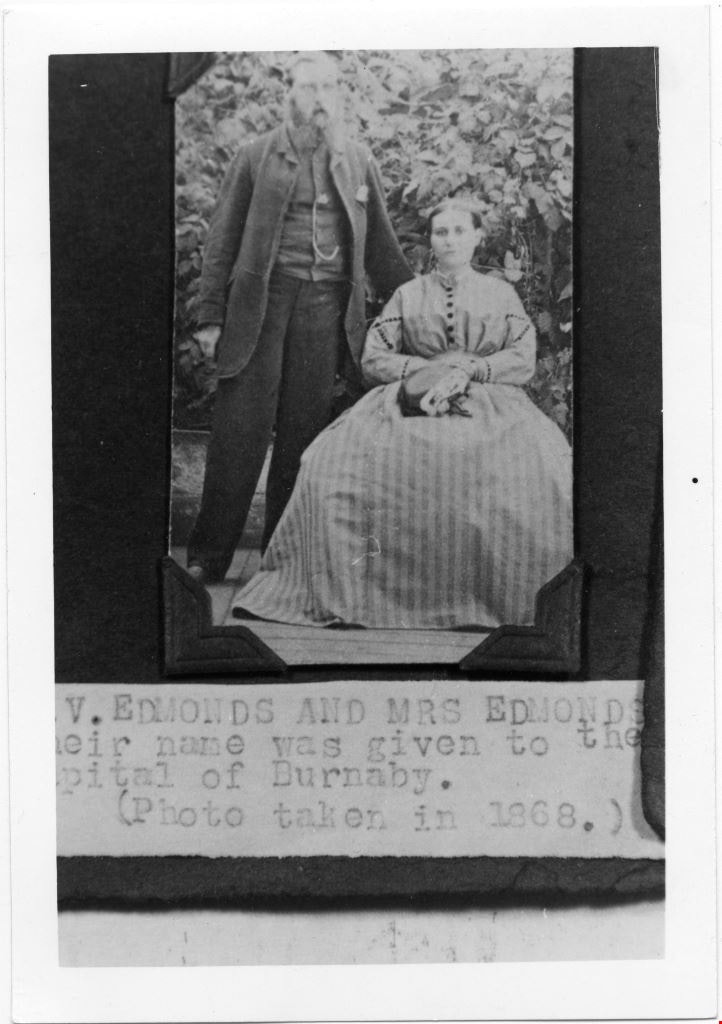
Mr and Mrs V Edmonds
https://search.heritageburnaby.ca/link/museumdescription4779
- Repository
- Burnaby Village Museum
- Date
- 1868
- Collection/Fonds
- Burnaby Village Museum Photograph collection
- Description Level
- Item
- Physical Description
- 1 photograph : b&w ; 12.6 x 8.8 cm ; copy print
- Scope and Content
- Portrait of married couple, he standing, she sitting, in front of some shrubbery.
- Repository
- Burnaby Village Museum
- Collection/Fonds
- Burnaby Village Museum Photograph collection
- Description Level
- Item
- Physical Description
- 1 photograph : b&w ; 12.6 x 8.8 cm ; copy print
- Material Details
- "Columbian files 1971" written on verso in black pen. "V. EDMONDS AND MRS EDMONDS / […]eir name was given to the / Capital of Burnaby. / (Photo taken in 1868.)" on typewritten label on front of photograph.
- Scope and Content
- Portrait of married couple, he standing, she sitting, in front of some shrubbery.
- History
- Part of a set of photographs from the Columbian Newspaper, which operated out of New Westminster under this name starting in 1900 until its dissolution in 1988. Photographs found in the collection of the Burnaby Village are dated 1971.
- Other Title Information
- title based on note on front of photograph
- Accession Code
- BV018.19.5
- Access Restriction
- No restrictions
- Reproduction Restriction
- May be restricted by third party rights
- Date
- 1868
- Media Type
- Photograph
- Scan Resolution
- 600
- Scan Date
- 24-04-2018
Images
![Survey and Subdivision plans in New Westminster District Group 1 – Burnaby
, [1861]-[1910] thumbnail](/media/hpo/_Data/_BVM_Cartographic_Material/1977/1977_0093_0019a_001.jpg?width=280)
Survey and Subdivision plans in New Westminster District Group 1 – Burnaby
https://search.heritageburnaby.ca/link/museumdescription6988
- Repository
- Burnaby Village Museum
- Date
- [1861]-[1910]
- Collection/Fonds
- Burnaby Village Museum Map collection
- Description Level
- File
- Physical Description
- 14 plans : 3 plans : black ink on paper hand col. + 7 plans : black ink on paper + 4 plans : graphite on paper mounted on 2 sides of cardboard 76 x 102 cm
- Scope and Content
- Item consists of a large board of four New Westminster District Gp 1 - subdivision plans mounted on one side and ten New Westminster District Gp 1 - subdivision plans mounted on the other side. Side A: 1. "Plan /of / Lots 166A, 166 and 167 /, Gr.1, N.W.D. / Showing Misconstructed Roads in Gree…
- Repository
- Burnaby Village Museum
- Collection/Fonds
- Burnaby Village Museum Map collection
- Description Level
- File
- Physical Description
- 14 plans : 3 plans : black ink on paper hand col. + 7 plans : black ink on paper + 4 plans : graphite on paper mounted on 2 sides of cardboard 76 x 102 cm
- Material Details
- Scales [between 1:2376 and 1:7920]
- Index number on edge of board reads: "19"
- Scope and Content
- Item consists of a large board of four New Westminster District Gp 1 - subdivision plans mounted on one side and ten New Westminster District Gp 1 - subdivision plans mounted on the other side. Side A: 1. "Plan /of / Lots 166A, 166 and 167 /, Gr.1, N.W.D. / Showing Misconstructed Roads in Green / 5 chs = 1 in.". (plan is drawn in black ink and hand coloured in red, green and orange ink). A section in the centre of the plan is coloured in red ink and identified as "C.S. Richmond" running from the North Arm of Fraser River to Wiggins Road and divided by "New Wiggins Rd. (as gazetted)" (coloured in orange ink) and two"Constructed Road(s)" (coloured in green ink). Plan is initialed by: "RB" [sic] (in blue pencil crayon) 2. Plan of / Subdivision of / Lot 166 / Group One / New Westminster District / Scale 4 chs = 1 in. / Map No 524". Plan is drawn in graphite and signed by "Surrig [sic] Welhams [sic] / P.L.S." Plan is initialed by: "RB" [sic] (in blue pencil crayon) 3. Plan of "Survey / of Highway / For / Burnaby Council / in / Lots 13 _14 / Group One / Scale 4 chs = 1 in." Signed by "Albert J. Hill, P.L.S." Caribou Street and Caribou Road run through the centre of the plan. Plan is stamped: "Albert J. Hill, Civil Engineer / and / Provincial Land Surveyor, / New Westminster, / B.C.". Plan is initialed by: "RB" [sic] (in blue pencil crayon) 4. A Plan of Lots 166A, 166 and 167, Group One, New Westminster District (drawn in graphite). A section in the centre of the plan is identified as "C.S. Richmond" running from the North Arm of Fraser River and divided by "New Wiggins Rd. (as gazetted)" and two "Constructed Road(s)". Plan is initialed by: "RB" [sic] (in blue pencil crayon) Side B: 1. Small plan drawn in black ink (no title) identifying lots north of the "North Arm" of the Fraser River. Lots identified include: Lot 99, Lot 98, Lot 157, Lot 158, Lot 163, Lot 162, Lot 159, Lot 163, Lot 162, Lot 165, Lot 166A, Lot 155B, Lot 155A and Lot 159. "Scale 40 chains to one inch" . Plan is initialed by: "RB" [sic] (in blue pencil crayon) (Geographic location: Burnaby) 2. Small plan drawn in black ink (no title) identifying lots north of the North Arm of the Fraser River as "Lots 155, 155A, 155B, 155C, 162, 163, 164, 165, 166A and 167". Plan is initialed by: "RB" [sic] (in blue pencil crayon) (Geographic location: Burnaby) 3. Small plan drawn in black ink (no title) which identifies "Lot 151 / Reserve/ for / Race Course"; "Reserve / 64 A / L. 152 G.1"; and other Lots: 32, 33, 34, 35, 36, 38, 39. The plan is signed "Surveyor G.Turn [sic] July / 61 / from Vol 40 R.L. notes [sic]" Plan is stamped: "Albert J. Hill, Civil Engineer / and / Provincial Land Surveyor, / New Westminster, / B.C." Plan is initialed by: "RB" [sic] (in blue pencil crayon) (Geographic location: Burnaby) 4. Small plan drawn in black in with faded red colouring on centre lot identified as "Lot 34" running north from "Vancouver Road" . Plan is stamped: "Albert J. Hill, Civil Engineer / and / Provincial Land Surveyor, / New Westminster, / B.C." Plan is initialed by: "RB" [sic] (in blue pencil crayon) (Geographic location: Burnaby) 5. Plan drawn in graphite and identified as "Lot 98, Gr.1," along with the intials "RB" [sic] (both are handwritten in blue crayon pencil on top of plan) The B.C.E.Railway is identified running through the plan along with Jubilee Road and Royal Oak Road. The plan is signed with the name "Wm. Murray" and the Plan is stamped: "Albert J. Hill, Civil Engineer / and / Provincial Land Surveyor, / New Westminster, / B.C.". (Geographic location: Burnaby) 6. Plan drawn in graphite identified as "Port Lot 13, Gr.1" along with the intials "RB" [sic] (both are handwritten in blue crayon pencil on top of plan) Plan is stamped: "Albert J. Hill, Civil Engineer / and / Provincial Land Surveyor, / New Westminster, / B.C.". (Geographic location: Burnaby) 7.Plan drawn in black ink and identified as "Lot 98 G.1" along with the intials "RB" [sic] (both are handwritten in blue crayon pencil on top of plan). A "Road Reservation" is identified running north between "Electric Tramway" and connecting with "Royal Oak Road". Plan is stamped: "Albert J. Hill, Civil Engineer / and / Provincial Land Surveyor, / New Westminster, / B.C." (Geographic location: Burnaby) 8. Plan drawn in black ink and divided into two sections, the upper plan is identified as "Portion / Lots 100 / area / 101, Gr.1" and the lower plan is identified as "Portion L. 3 G. 1" along with the intials "RB" [sic] (these identifiers are handwritten in blue crayon pencil on top of the plan). Portions of Lot 100 and Lot 101 are each divided into 6 sections and the Portion of Lot 3 plan is divided into 24 sections. The plan includes a note in black ink that reads: " Received from Wm Fromme [sic] / from Wm. Trapp / Nov. 28, 1895 / A. J. T...[sic]". (Geographic location: Burnaby) 9. Plan drawn in black ink (no title) identifying soil, buildings and geographic features in southern Burnaby. The plan is bordered by "New Westminster City" (Tenth Avenue and DL 172) to the south east and DL 173 to the south, DL 158 to the west and the B.C.E. Tramway to the north. Plan includes District Lots: 155A, 158, 159, 171, 160, 53 and 95 and identifies soil, marshland and ravines throughout. Plan identifies the following features: a "Team Road" running through Lots 158 and 159 along with "Fair Orchard Soil / Even Surface Throughout / No Ravines", "Gravel and Shingle" (bottom of Lot 158), "North Arm Road" crossing "Byrne Road" and connecting with "Power House Road" which runs north to connect with "Highland Park Station" and the B.C.E. Tramway, "Power Ho" in the northeast corner of DL 160, a "Brook" connected with a "Deep Ravine" running between DL 53, DL 95 and DL 160 along with "Good Soil" and "Fair Orchard Soil" identified nearby in DL 95. Scale is identified as "10 chs = 1 in." Plan is stamped: "Albert J. Hill, Civil Engineer / and / Provincial Land Surveyor, / New Westminster, / B.C." Plan is initialed by: "RB" [sic] (in blue pencil crayon) (Geographic location: Burnaby) 10. Plan drawn in black ink (no title) with Burnaby Lake and Deer Lake at the centre. The plan is bordered by the following District Lots identified as: 117, 118 and 68 to the west, Lots 80, 79 and 85 to the southwest, Lots 11, 13, and 1 (City of New Westminster) to the south east, the North Road boundary to the east and Lots 8, 56, 57, 59, and 136 to the North. The lower right hand corner of the plan has a small inset which reads: "Burnaby Lake" and "Page 19 R.B. Notes". Plan is initialed by: "RB" [sic] (in blue pencil crayon) (Geographic location: Burnaby)
- Creator
- Hill, Albert James
- Accession Code
- HV977.93.19
- Access Restriction
- No restrictions
- Reproduction Restriction
- No known restrictions
- Date
- [1861]-[1910]
- Media Type
- Cartographic Material
- Scan Resolution
- 300
- Scale
- 72
- Notes
- Title based on contents of file
- Scale is measured in chains. (One chain equals 792 inches)
- The term "Lot" can also refer to a "District Lot”
- Some plans are stamped: "Albert J. Hill, Civil Engineer / and / Provincial Land Surveyor, / New Westminster, / B.C." and intialed: "RB" [sic]
Images
![Survey and Subdivision plans in New Westminster District Group 1 – Burnaby
, [1861]-[1910] thumbnail](/media/hpo/_Data/_BVM_Cartographic_Material/1977/1977_0093_0019a_001.jpg)

![Survey and Subdivision plans in New Westminster District Group 1 – Burnaby, Port Moody, [1862-1908] thumbnail](/media/hpo/_Data/_BVM_Cartographic_Material/1977/1977_0093_0026a_001.jpg?width=280)
Survey and Subdivision plans in New Westminster District Group 1 – Burnaby, Port Moody
https://search.heritageburnaby.ca/link/museumdescription6995
- Repository
- Burnaby Village Museum
- Date
- [1862-1908]
- Collection/Fonds
- Burnaby Village Museum Map collection
- Description Level
- File
- Physical Description
- 9 plans : 6 plans : black ink on paper ; 57 x 36.5 cm or smaller + 1 plan : black ink and grahite on paper ; 46.5 x 49 cm + 1 plan : blueprint on paper ; 15.5 x 19.5 cm + cm + 1 plan : graphite on paper ; 25 x 17 cm ; mounted on both sides of board 76 x 102 cm
- Scope and Content
- Item consists of a large board of four New Westminster District subdivision plans mounted on one side and five New Westminster District subdivision plans mounted on the other side. Side A: 1. "Plan / of Subdivision / of a Portion / of / Lot 87 / Group One / New Westminster District / Scale 4 chs…
- Repository
- Burnaby Village Museum
- Collection/Fonds
- Burnaby Village Museum Map collection
- Description Level
- File
- Physical Description
- 9 plans : 6 plans : black ink on paper ; 57 x 36.5 cm or smaller + 1 plan : black ink and grahite on paper ; 46.5 x 49 cm + 1 plan : blueprint on paper ; 15.5 x 19.5 cm + cm + 1 plan : graphite on paper ; 25 x 17 cm ; mounted on both sides of board 76 x 102 cm
- Material Details
- Scales [between 1:792 and 1:3600]
- Index number on edge of board reads: "26"
- Scope and Content
- Item consists of a large board of four New Westminster District subdivision plans mounted on one side and five New Westminster District subdivision plans mounted on the other side. Side A: 1. "Plan / of Subdivision / of a Portion / of / Lot 87 / Group One / New Westminster District / Scale 4 chs = 1 in". Plan is stamped: "Albert J. Hill, Civil Engineer / and / Provincial Land Surveyor, / New Westminster, / B.C." and intialed by: "RB" [sic] (in blue pencil crayon). Names two of the subdivisons of District Lot 87 are identified as, "L.E. Sprott" and "John Ledger". (Geographic location: Burnaby) 2. "Plan of Subdivision / of / Portions of / Lot 136, 131 and Lots 44 and 78 Gr.1 / New Westminster District / Scale 300 ft = 1 inch". Annotation above title reads: "No. 901 / Deposited in Land Registry Office / New Westminster / Aug. 19th 1905 / Charles S. Keith D. Reg." Annotations and signatures at bottom of plan read: "I, William Nelson Draper, / W.H.R. Collister / Charles E. Perkins / E.B. Morgan / make / Surveys / correct / representation / upon / the / Land Registry Act / (sgd) W.N. Draper, P.L.S.". Plan includes a handwritten title: "Lots 136, 131, 44 & 78" and is initialed: "RB" [sic] (in blue pencil crayon) (Geographic location: Burnaby) 3. "Survey / of / a Portion / of / Lot 95, Gr.1 / Scale 1 ch = 1in." Plan is stamped: "Albert J. Hill, Civil Engineer / and / Provincial Land Surveyor, / New Westminster, / B.C." and is initialed : "RB" [sic] (in blue pencil crayon) (Geographic location: Burnaby) 4. Blueprint plan of "Lot 396. Group One." with Scale : 3 chs = 1 in. A two acre portion of District Lot 396 is filled in with red ink." Plan is signed by "Albert J. Hill / B.C.L.S." (Geographic location: Port Moody) Side B: 1. Plan titled "District Lot 92 / Burnaby / Municipality / for sale by / Mahon / McFarland & / Mahon Ltd. / Vancouver, B.C. / Scale : 4 chains to one inch". District Lot 92 is subdivided into 161 lots and identifies roads: Norwich Road, Pole Line Road, Oakland Road, Stanley Road, Burford Road, Dalhousie Road, Brantford Road, Colborne Road, Roberts Road, Vancouver & Westminster Road, B.C. Electric Railway, Gilley Stn. and Burnaby (Power House). The bottom of the plan reads: "G.S. Dawson, P.LS. Vancouver, B.C." (Geographic location: Burnaby) 2. "Plan / of Subdivision / of a Portion / of / Lot 29 / Group 1 / New Westminster District / Scale 2 chs = 1 in". Plan is stamped: "Albert J. Hill, Civil Engineer / and / Provincial Land Surveyor, / New Westminster, / B.C." and is initialed by: "RB" [sic] (in blue pencil crayon) (Geographic location: Burnaby) 3. Small handrawn plan (no title) identifying "Lot 84 / Hydes, Claim" at the centre surrounded by lots and features identified as: "Lot 85", "Lot 93", "Lot 94", "Lot 32", "Lot 82", "Lot 83", "Lot 79", "swamp" and a "Small Lake" (Burnaby Lake). Identifying marks in the right corner of the plan read: "Page 13 / Surveyed by G. Turner / May 62". Plan also includes surveyor's bearing measurements and trails to "Small Lake" (Burnaby Lake). (Geographic location: Burnaby) 4. Untitled plan showing District Lots west of North Road and north of Burnaby Lake including: Lots 2, 4, 6, 8, 15, 10, 56, 148, 57, 58, 40. and Lots 3, 5, 7 east of North Road (Coquitlam). Lots in Burnaby are identifed for timber including: "Heavily Timbered" (Lot 57), " "Some Fir and Cedar" (Lot 40), "Splendid Fir and Cedar" (Lot 143), "Heavy Fir etc" (Lots 143 and 148), " "Fine Cedar" (Lot 15), "Rough Light Timber" (Lot 56). Other features identified at the lower portion of the plan include "Burnaby Lake" and "Brunette River". (Geographic location: Burnaby) 5. Untitled plan drawn in graphite showing sections of District Lot 85 south of Burnaby Lake and north of Hazsard Road. Plan is signed: "Albert J. Hill / B.C.L.S." and dated "12/26/08". Plan is initialed by: "RB" [sic] (in blue pencil crayon) (Geographic location: Burnaby)
- Publisher
- Mahon, McFarland & Mahon Ltd
- Accession Code
- HV977.93.26
- Access Restriction
- No restrictions
- Reproduction Restriction
- No known restrictions
- Date
- [1862-1908]
- Media Type
- Cartographic Material
- Historic Neighbourhood
- Burnaby Lake (Historic Neighbourhood)
- Burquitlam (Historic Neighbourhood)
- Planning Study Area
- Burnaby Lake Area
- Scan Resolution
- 300
- Scale
- 72
- Notes
- Title based on contents of file
- Scale is measured in chains and feet. (One chain equals 792 inches)
- The term "Lot" can also refer to a "District Lot”
Images
![Survey and Subdivision plans in New Westminster District Group 1 – Burnaby, Port Moody, [1862-1908] thumbnail](/media/hpo/_Data/_BVM_Cartographic_Material/1977/1977_0093_0026a_001.jpg)


Esther Stanley (nee Love)
https://search.heritageburnaby.ca/link/museumdescription9860
- Repository
- Burnaby Village Museum
- Date
- 1876 (date of original)-[1998]
- Collection/Fonds
- Burnaby Village Museum fonds
- Description Level
- File
- Physical Description
- 1 cm of textual records
- Scope and Content
- File consists of copies of marriage, birth and death certificates along with copies of biographical information from Pioneer Tales and related correspondence. Esther Stanley (nee Love) was born in 1896, married Frank Charles Stanley in 1921 and is the daughter of Jesse and Martha Love.
- Repository
- Burnaby Village Museum
- Collection/Fonds
- Burnaby Village Museum fonds
- Series
- Jesse Love farmhouse series
- Subseries
- Love farmhouse research files subseries
- Description Level
- File
- Physical Description
- 1 cm of textual records
- Scope and Content
- File consists of copies of marriage, birth and death certificates along with copies of biographical information from Pioneer Tales and related correspondence. Esther Stanley (nee Love) was born in 1896, married Frank Charles Stanley in 1921 and is the daughter of Jesse and Martha Love.
- Names
- Stanley, Esther Love
- Accession Code
- BV018.41.71
- Access Restriction
- Subject to FIPPA
- Reproduction Restriction
- Reproductions subject to FIPPA
- Date
- 1876 (date of original)-[1998]
- Media Type
- Textual Record
- Notes
- Title based on content of file
![Richard Love, [ca. 1870] thumbnail](/media/hpo/_Data/_BVM_Images/2018/2018_0041_0181_001.jpg?width=280)
Richard Love
https://search.heritageburnaby.ca/link/museumdescription9996
- Repository
- Burnaby Village Museum
- Date
- [ca. 1870]
- Collection/Fonds
- Burnaby Village Museum fonds
- Description Level
- Item
- Physical Description
- 1 photograph : b&w negative ; 35 mm
- Scope and Content
- Photograph portrait of Richard Love seated next to a decorative wooden desk. He is seated on a chair with a velvet and tassels and is wearing a large black suit coat, a white blouse with a tie at the collar, pants with long velvet chaps that go up to his knees and cover the tops of his shoes. He is…
- Repository
- Burnaby Village Museum
- Collection/Fonds
- Burnaby Village Museum fonds
- Series
- Jesse Love farmhouse series
- Subseries
- Love family photographs subseries
- Description Level
- Item
- Physical Description
- 1 photograph : b&w negative ; 35 mm
- Scope and Content
- Photograph portrait of Richard Love seated next to a decorative wooden desk. He is seated on a chair with a velvet and tassels and is wearing a large black suit coat, a white blouse with a tie at the collar, pants with long velvet chaps that go up to his knees and cover the tops of his shoes. He is holding a wooden cane between his legs and there is a top hat and a book on top of the desk and a back drop hanging from the wall behind him. Richard Love is the father of Jesse Love.
- Names
- Love, Richard
- Accession Code
- BV018.41.181
- Access Restriction
- No restrictions
- Reproduction Restriction
- May be restricted by third party rights
- Date
- [ca. 1870]
- Media Type
- Photograph
- Scan Resolution
- 2400
- Scan Date
- 4-Mar-2019
- Scale
- 100
- Photographer
- Dodson, Z.
- Notes
- Title based on contents of photograph
- 1 b&w copy print accompanying
- Stamp in black ink on verso of original photograph reads: "Z.DODSON, / Photographer / PROSPECT PLACE, / NEAR VICTORIA STREET / SWINDON."
Images
![Richard Love, [ca. 1870] thumbnail](/media/hpo/_Data/_BVM_Images/2018/2018_0041_0181_001.jpg)
![Elizabeth Love, [ca. 1870] thumbnail](/media/hpo/_Data/_BVM_Images/2018/2018_0041_0182_001.jpg?width=280)
Elizabeth Love
https://search.heritageburnaby.ca/link/museumdescription9997
- Repository
- Burnaby Village Museum
- Date
- [ca. 1870]
- Collection/Fonds
- Burnaby Village Museum fonds
- Description Level
- Item
- Physical Description
- 1 photograph : b&w negative ; 35 mm
- Scope and Content
- Photograph portrait of Elizabeth Love (nee Prince) seated next to a decorative wooden desk with a book on top. She is seated on a velvet chair and is wearing a long black silk dress with a decorative lace collar and bonnet. Eizabeth Love was married to Richard Love and is the mother of Jesse Love.
- Repository
- Burnaby Village Museum
- Collection/Fonds
- Burnaby Village Museum fonds
- Series
- Jesse Love farmhouse series
- Subseries
- Love family photographs subseries
- Description Level
- Item
- Physical Description
- 1 photograph : b&w negative ; 35 mm
- Scope and Content
- Photograph portrait of Elizabeth Love (nee Prince) seated next to a decorative wooden desk with a book on top. She is seated on a velvet chair and is wearing a long black silk dress with a decorative lace collar and bonnet. Eizabeth Love was married to Richard Love and is the mother of Jesse Love.
- Accession Code
- BV018.41.182
- Access Restriction
- No restrictions
- Reproduction Restriction
- May be restricted by third party rights
- Date
- [ca. 1870]
- Media Type
- Photograph
- Scan Resolution
- 2400
- Scan Date
- 4-Mar-2019
- Scale
- 100
- Notes
- Title based on contents of photograph
- 1 b&w copy print accompanying
- Stamp in black ink on verso of original photograph reads: "Z.DODSON, / PORTRAIT AND LANDSCAPE / PHOTOGRAPHER / PROSPECT PLACE, / (Near Victoria Street.) / SWINDON."
Images
![Elizabeth Love, [ca. 1870] thumbnail](/media/hpo/_Data/_BVM_Images/2018/2018_0041_0182_001.jpg)
Letter re payment of Lot No. 1, Group 1, New Westminster District
https://search.heritageburnaby.ca/link/museumdescription10404
- Repository
- Burnaby Village Museum
- Date
- 6 Mar. 1860
- Collection/Fonds
- William Holmes fonds
- Description Level
- Item
- Physical Description
- 1 p. textual record ; folded
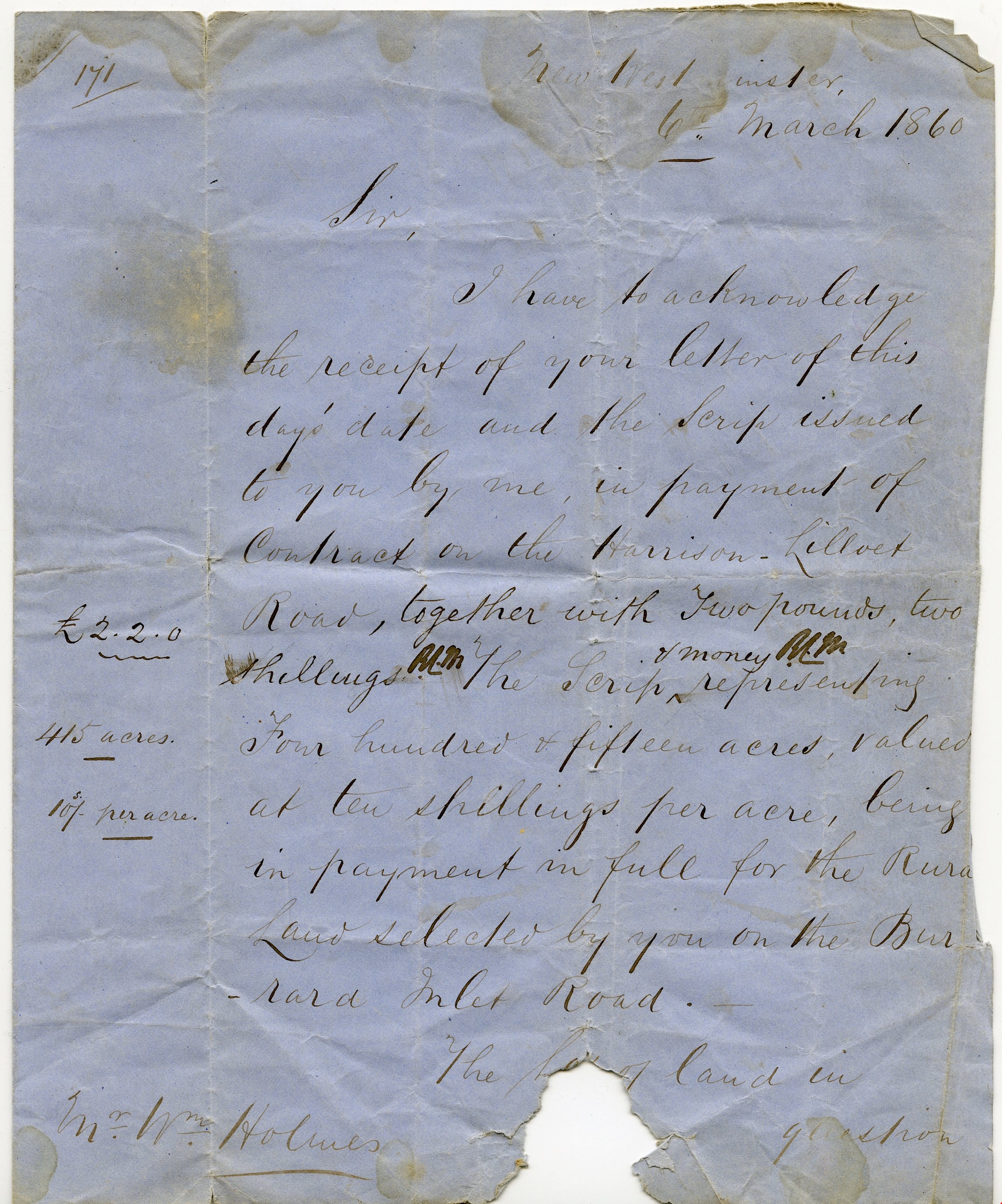
- Scope and Content
- Item consists of a handwritten letter on blue paper dated "6th March 1860". The letter is addressed to Mr. Wm. Holmes from Colonel Moody regarding payment of a contract on Harrison Lilloet Road and two pounds two shillings scrip payment for land on Burrard Inlet Road..."Lot No. 1, Group 1, Rural La…
- Repository
- Burnaby Village Museum
- Collection/Fonds
- William Holmes fonds
- Description Level
- Item
- Physical Description
- 1 p. textual record ; folded
- Scope and Content
- Item consists of a handwritten letter on blue paper dated "6th March 1860". The letter is addressed to Mr. Wm. Holmes from Colonel Moody regarding payment of a contract on Harrison Lilloet Road and two pounds two shillings scrip payment for land on Burrard Inlet Road..."Lot No. 1, Group 1, Rural Land, New Westminster District..."
- Accession Code
- BV997.50.3
- Access Restriction
- No restrictions
- Reproduction Restriction
- No known restrictions
- Date
- 6 Mar. 1860
- Media Type
- Textual Record
- Scan Resolution
- 300
- Scan Date
- 06-May-2019
- Notes
- Title based on contents of item
Images

Certificate of Title
https://search.heritageburnaby.ca/link/museumdescription10407
- Repository
- Burnaby Village Museum
- Date
- 20 Feb. 1861
- Collection/Fonds
- William Holmes fonds
- Description Level
- Item
- Physical Description
- 1 certificate
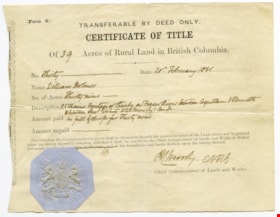
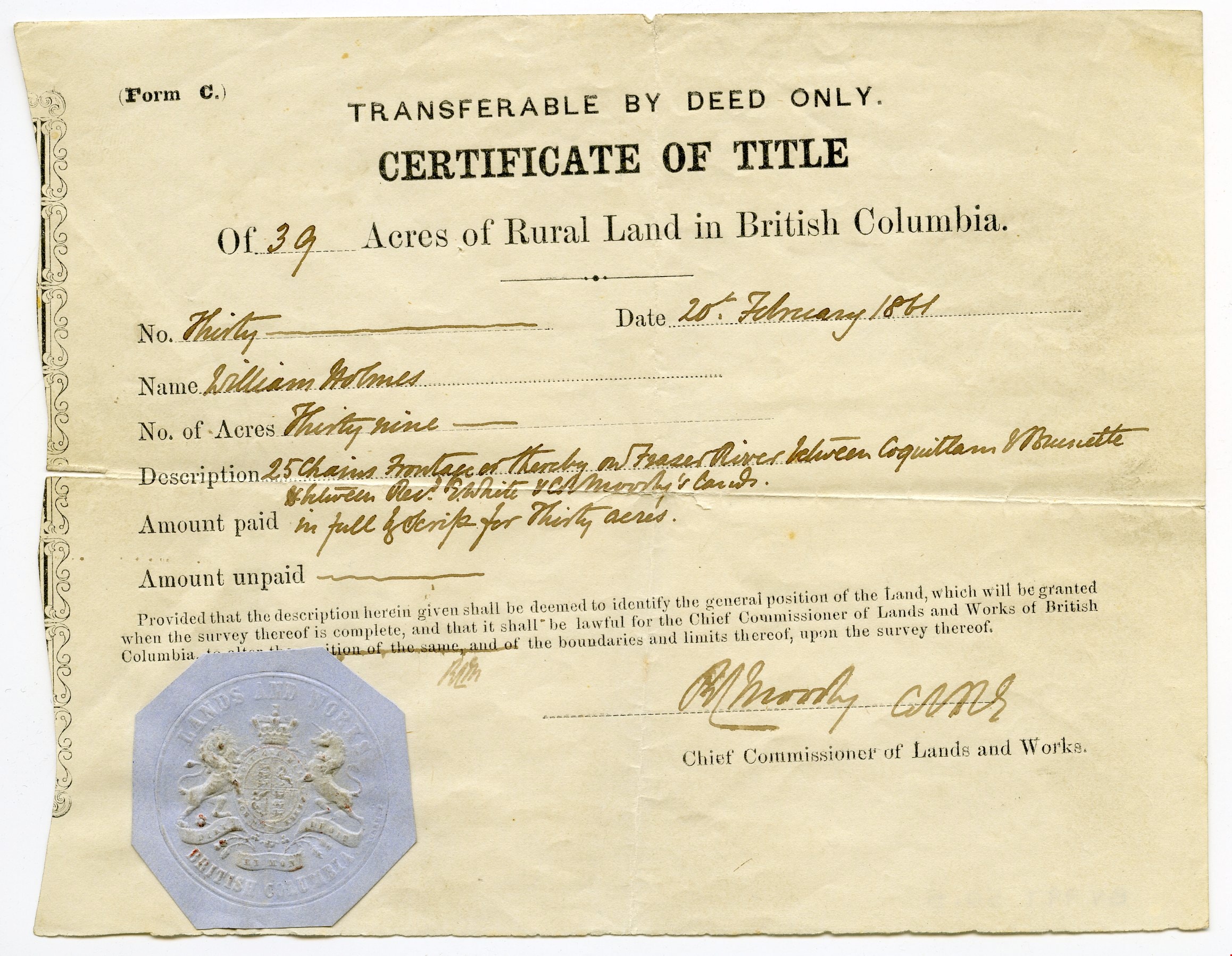
- Scope and Content
- Item consists of "Certificate of Title" to Mr. William Holmes for land in Burnaby/NE Westminster; "39 Acres", "20th February 1861". "Description" reads: "25 Chains Frontage on thereby on Fraser River between Coquitlam & Brunette / between Rev. E. White & Col. Moody's [?]". The blue Provincial seal…
- Repository
- Burnaby Village Museum
- Collection/Fonds
- William Holmes fonds
- Description Level
- Item
- Physical Description
- 1 certificate
- Scope and Content
- Item consists of "Certificate of Title" to Mr. William Holmes for land in Burnaby/NE Westminster; "39 Acres", "20th February 1861". "Description" reads: "25 Chains Frontage on thereby on Fraser River between Coquitlam & Brunette / between Rev. E. White & Col. Moody's [?]". The blue Provincial seal is affixed to the certificate and it is signed by R.C. Moody, "Chief Commissioner of Lands and Works".
- Accession Code
- BV997.50.5
- Access Restriction
- No restrictions
- Reproduction Restriction
- No known restrictions
- Date
- 20 Feb. 1861
- Media Type
- Textual Record
- Scan Resolution
- 300
- Scan Date
- 06-May-2019
- Notes
- Title based on contents of item
Images
Certificate of Title
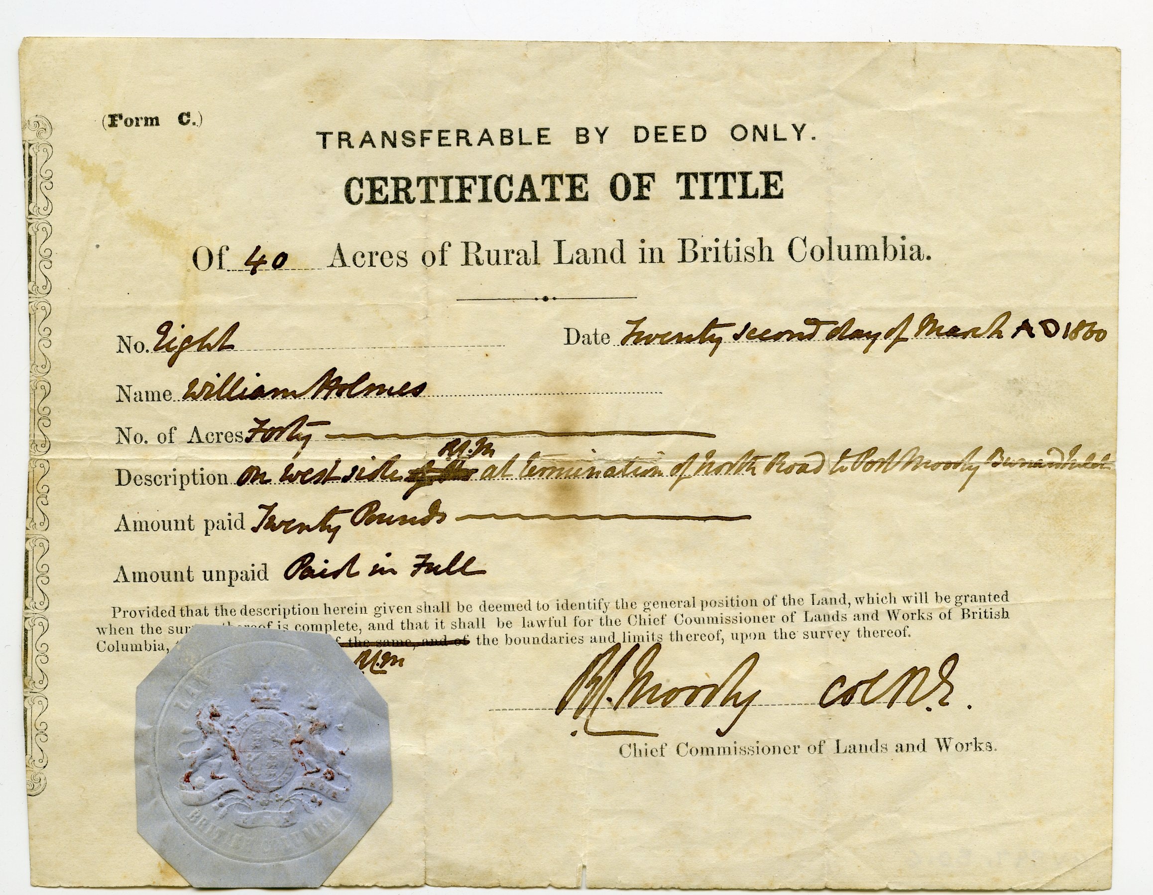
https://search.heritageburnaby.ca/link/museumdescription10408
- Repository
- Burnaby Village Museum
- Date
- 22 Mar. 1860
- Collection/Fonds
- William Holmes fonds
- Description Level
- Item
- Physical Description
- 1 certificate
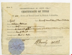
- Scope and Content
- Item consists of "Certificate of Title" to Mr. William Holmes for land in Burnaby/NE Westminster; "40 Acres", "Twenty Second Day of March AD 1860". Description reads: "On West Side at termination of North Road to Port Moody Burrard Inlet". The blue Provincial seal is affixed to the certificate and…
- Repository
- Burnaby Village Museum
- Collection/Fonds
- William Holmes fonds
- Description Level
- Item
- Physical Description
- 1 certificate
- Scope and Content
- Item consists of "Certificate of Title" to Mr. William Holmes for land in Burnaby/NE Westminster; "40 Acres", "Twenty Second Day of March AD 1860". Description reads: "On West Side at termination of North Road to Port Moody Burrard Inlet". The blue Provincial seal is affixed to the certificate and it is signed by R.C. Moody, "Chief Commissioner of Lands and Works".
- Accession Code
- BV997.50.6
- Access Restriction
- No restrictions
- Reproduction Restriction
- No known restrictions
- Date
- 22 Mar. 1860
- Media Type
- Textual Record
- Scan Resolution
- 300
- Scan Date
- 06-May-2019
- Notes
- Title based on contents of item
Images