Narrow Results By
Decade
- 2020s 182
- 2010s
- 2000s
- 1990s 1029
- 1980s 844
- 1970s 2044
- 1960s 740
- 1950s 938
- 1940s 1286
- 1930s 1381
- 1920s 1644
- 1910s
- 1900s 969
- 1890s 350
- 1880s 141
- 1870s 51
- 1860s 52
- 1850s 26
- 1840s 17
- 1830s 8
- 1820s 5
- 1810s 5
- 1800s
- 1790s 4
- 1780s 3
- 1770s 3
- 1760s 3
- 1750s 3
- 1740s 3
- 1730s 3
- 1720s 3
- 1710s 5
- 1700s 4
- 1690s 3
- 1680s 4
- 1670s 3
- 1660s 3
- 1650s 3
- 1640s 3
- 1630s 3
- 1620s 3
- 1610s 3
- 1600s 3
- 1520s 1
Creator
- A. A. Marks (firm) 1
- Abbott, George Knapp, 1880-1959 1
- Addingley, Amy 1
- Adee, J. N. 1
- Alcott, Louisa May, 1832-1888 2
- Alexander, Charles M. (Charles McCallon), 1867-1920 1
- Alexander, William John, 1855-1944 1
- Allan, Tony, 1946- 1
- Allardyce, Mrs. 1
- Allen, James Lane, 1849-1925 1
- Allen, John Robins, 1869-1920 1
- Allen, Philip Schuyler, 1871-1937 1
![Leggett children at the Lone Star circus, [between 1900 and 1919] thumbnail](/media/hpo/_Data/_BVM_Images/2000/200400940002.jpg?width=280)
Leggett children at the Lone Star circus
https://search.heritageburnaby.ca/link/museumdescription1780
- Repository
- Burnaby Village Museum
- Date
- [between 1900 and 1919]
- Collection/Fonds
- Fred K. Leggett family fonds
- Description Level
- Item
- Physical Description
- 1 photograph : sepia ; 10 x 6.5 cm
- Scope and Content
- Photograph of (from left) Leon Leggett, Norvie Leggett, Dedie Leggett and Fred Leggett J standing in front of a mechanical ride. The man standing at the back with the black hat is the children's father, Fred Kirk Leggett from Houston, Texas (the original owner of Parker Carousel no. 119). He owned …
- Repository
- Burnaby Village Museum
- Collection/Fonds
- Fred K. Leggett family fonds
- Description Level
- Item
- Physical Description
- 1 photograph : sepia ; 10 x 6.5 cm
- Scope and Content
- Photograph of (from left) Leon Leggett, Norvie Leggett, Dedie Leggett and Fred Leggett J standing in front of a mechanical ride. The man standing at the back with the black hat is the children's father, Fred Kirk Leggett from Houston, Texas (the original owner of Parker Carousel no. 119). He owned the Lone Star circus and the airship was part of the circus attraction.
- Accession Code
- BV004.94.2
- Access Restriction
- No restrictions
- Reproduction Restriction
- No known restrictions
- Date
- [between 1900 and 1919]
- Media Type
- Photograph
- Scan Resolution
- 600
- Scan Date
- 09-Jun-09
- Scale
- 100
- Notes
- Title based on contents of photograph
- Note on verso of photograph reads: "Children standing by Airship"
Images
![Leggett children at the Lone Star circus, [between 1900 and 1919] thumbnail](/media/hpo/_Data/_BVM_Images/2000/200400940002.jpg)
![Teachers at Burnaby West School, [between 1900 and 1910] thumbnail](/media/hpo/_Data/_BVM_Images/2012/2012_0020_0007_001.jpg?width=280)
Teachers at Burnaby West School
https://search.heritageburnaby.ca/link/museumdescription2944
- Repository
- Burnaby Village Museum
- Date
- [between 1900 and 1910]
- Collection/Fonds
- Burnaby Village Museum Photograph collection
- Description Level
- Item
- Physical Description
- 1 photograph : b&w oval ; 16 x 10 cm in decorative oval paper frame
- Scope and Content
- Photograph of five female teachers at West Burnaby School (renamed Kingsway West School). The group is standing in front of a stone wall.
- Repository
- Burnaby Village Museum
- Collection/Fonds
- Burnaby Village Museum Photograph collection
- Description Level
- Item
- Physical Description
- 1 photograph : b&w oval ; 16 x 10 cm in decorative oval paper frame
- Material Details
- Oval image of the five women surrounded by a white oval frame and then a black paper frame with plant silhouettes
- Scope and Content
- Photograph of five female teachers at West Burnaby School (renamed Kingsway West School). The group is standing in front of a stone wall.
- Subjects
- Occupations - Teachers
- Names
- Kingsway West School
- Geographic Access
- Kingsway
- Street Address
- 4800 Kingsway
- Accession Code
- BV012.20.7
- Date
- [between 1900 and 1910]
- Media Type
- Photograph
- Historic Neighbourhood
- Central Park (Historic Neighbourhood)
- Planning Study Area
- Maywood Area
- Related Material
- Another copy of the same image is accessioned as BV999.2.43.
- Scan Resolution
- 600
- Scan Date
- 13-Mar-2018
- Notes
- Title based on contents of photograph.
Images
![Teachers at Burnaby West School, [between 1900 and 1910] thumbnail](/media/hpo/_Data/_BVM_Images/2012/2012_0020_0007_001.jpg)
![Royle brothers
, [191-] thumbnail](/media/hpo/_Data/_BVM_Images/2006/2006_0039_0005_001.jpg?width=280)
Royle brothers
https://search.heritageburnaby.ca/link/museumdescription2953
- Repository
- Burnaby Village Museum
- Date
- [191-]
- Collection/Fonds
- Harry Royle fonds
- Description Level
- Item
- Physical Description
- 1 photograph : sepia ; 14 x 9.5 cm mounted on matt 27 x 16 cm
- Scope and Content
- Photograph studio portrait of (left) Harry Royle with his brothers, Joe Royle, and George V. Royle. All three men are wearing suits with cap style hats.
- Repository
- Burnaby Village Museum
- Collection/Fonds
- Harry Royle fonds
- Description Level
- Item
- Physical Description
- 1 photograph : sepia ; 14 x 9.5 cm mounted on matt 27 x 16 cm
- Scope and Content
- Photograph studio portrait of (left) Harry Royle with his brothers, Joe Royle, and George V. Royle. All three men are wearing suits with cap style hats.
- Accession Code
- BV006.39.5
- Access Restriction
- No restrictions
- Reproduction Restriction
- No known restrictions
- Date
- [191-]
- Media Type
- Photograph
- Related Material
- Similar photo to BV006.39.6
- Scan Date
- 2024-01-08
- Notes
- Title based on contents of photograph
- Photograph studio insignia in gold in bottom right corner beneath photograph reads: "Welford / 303 Hastings Street W / Vancouver, B.C."
- City of Burnaby Archives holds a copy of this photograph that was published in Pioneer Tales of Burnaby- see 204-267
Images
![Royle brothers
, [191-] thumbnail](/media/hpo/_Data/_BVM_Images/2006/2006_0039_0005_001.jpg)
![Royle brothers
, [191-] thumbnail](/media/hpo/_Data/_BVM_Images/2006/2006_0039_0006_001.jpg?width=280)
Royle brothers
https://search.heritageburnaby.ca/link/museumdescription2954
- Repository
- Burnaby Village Museum
- Date
- [191-]
- Collection/Fonds
- Harry Royle fonds
- Description Level
- Item
- Physical Description
- 1 photograph : sepia ; 14 x 9.5 cm mounted on matt 27 x 16 cm
- Scope and Content
- Photograph studio portrait of (left) Harry Royle with his brothers, Joe Royle, and George V. Royle. All three men are wearing suits with cap style hats.
- Repository
- Burnaby Village Museum
- Collection/Fonds
- Harry Royle fonds
- Description Level
- Item
- Physical Description
- 1 photograph : sepia ; 14 x 9.5 cm mounted on matt 27 x 16 cm
- Scope and Content
- Photograph studio portrait of (left) Harry Royle with his brothers, Joe Royle, and George V. Royle. All three men are wearing suits with cap style hats.
- Accession Code
- BV006.39.6
- Access Restriction
- No restrictions
- Reproduction Restriction
- No known restrictions
- Date
- [191-]
- Media Type
- Photograph
- Related Material
- Similar photo to BV006.39.5
- Scan Date
- 2024-01-08
- Notes
- Title based on contents of photograph
Images
![Royle brothers
, [191-] thumbnail](/media/hpo/_Data/_BVM_Images/2006/2006_0039_0006_001.jpg)
![Interior of butcher shop, [1900?] thumbnail](/media/hpo/_Data/_BVM_Images/1971/197301100005.jpg?width=280)
Interior of butcher shop
https://search.heritageburnaby.ca/link/museumdescription3074
- Repository
- Burnaby Village Museum
- Date
- [1900?]
- Collection/Fonds
- Burnaby Village Museum Photograph collection
- Description Level
- Item
- Physical Description
- 1 photograph : b&w glass negative
- Scope and Content
- Interior view of an unidentified butcher shop shows meat hanging on racks from the ceiling, and a man standing by a counter.
- Repository
- Burnaby Village Museum
- Collection/Fonds
- Burnaby Village Museum Photograph collection
- Description Level
- Item
- Physical Description
- 1 photograph : b&w glass negative
- Scope and Content
- Interior view of an unidentified butcher shop shows meat hanging on racks from the ceiling, and a man standing by a counter.
- Accession Code
- HV973.110.5
- Access Restriction
- No restrictions
- Reproduction Restriction
- No known restrictions
- Date
- [1900?]
- Media Type
- Photograph
- Scan Resolution
- 300
- Scan Date
- 16/8/2006
- Scale
- 100
- Notes
- Title based on contents of photograph
- 1 b&w contact print accompanying negative
Images
![Interior of butcher shop, [1900?] thumbnail](/media/hpo/_Data/_BVM_Images/1971/197301100005.jpg)
![Two women with child on rocking horse, [1900] thumbnail](/media/hpo/_Data/_BVM_Images/1971/197301100008.jpg?width=280)
Two women with child on rocking horse
https://search.heritageburnaby.ca/link/museumdescription3077
- Repository
- Burnaby Village Museum
- Date
- [1900]
- Collection/Fonds
- Burnaby Village Museum Photograph collection
- Description Level
- Item
- Physical Description
- 1 photograph : b&w glass negative
- Scope and Content
- Photograph of unidentified women are standing by the door of a house, and a child is riding on a rocking horse on the porch. The image is duplicated in a double exposure.
- Repository
- Burnaby Village Museum
- Collection/Fonds
- Burnaby Village Museum Photograph collection
- Description Level
- Item
- Physical Description
- 1 photograph : b&w glass negative
- Scope and Content
- Photograph of unidentified women are standing by the door of a house, and a child is riding on a rocking horse on the porch. The image is duplicated in a double exposure.
- Subjects
- Toys
- Accession Code
- HV973.110.8
- Access Restriction
- No restrictions
- Reproduction Restriction
- No known restrictions
- Date
- [1900]
- Media Type
- Photograph
- Scan Resolution
- 300
- Scan Date
- 16/8/2006
- Scale
- 100
- Notes
- Title based on contents of photograph
- 1 b&w contact print accompanying negative
Images
![Two women with child on rocking horse, [1900] thumbnail](/media/hpo/_Data/_BVM_Images/1971/197301100008.jpg)
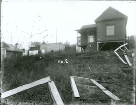
House with a broken wire fence
https://search.heritageburnaby.ca/link/museumdescription3079
- Repository
- Burnaby Village Museum
- Date
- [between 1900 and 1910
- Collection/Fonds
- Burnaby Village Museum Photograph collection
- Description Level
- Item
- Physical Description
- 1 photograph : b&w glass negative
- Scope and Content
- Photograph of an unidentified house with a broken wire fence in its front lawn. There are a couple of houses seen nearby the house and power poles running along a road behind the houses.
- Repository
- Burnaby Village Museum
- Collection/Fonds
- Burnaby Village Museum Photograph collection
- Description Level
- Item
- Physical Description
- 1 photograph : b&w glass negative
- Material Details
- inscribed in the negative, printed on the photograph, c. "no.2"
- Scope and Content
- Photograph of an unidentified house with a broken wire fence in its front lawn. There are a couple of houses seen nearby the house and power poles running along a road behind the houses.
- Accession Code
- HV973.110.10
- Access Restriction
- No restrictions
- Reproduction Restriction
- No known restrictions
- Date
- [between 1900 and 1910
- Media Type
- Photograph
- Scan Resolution
- 300
- Scan Date
- 16/8/2006
- Scale
- 100
- Notes
- Title based on contents of photograph
- 1 b&w contact print accompanying negative
Images

![Community along the bank of a creek, [between 1900 and 1915] thumbnail](/media/hpo/_Data/_BVM_Images/1971/197301100011.jpg?width=280)
Community along the bank of a creek
https://search.heritageburnaby.ca/link/museumdescription3080
- Repository
- Burnaby Village Museum
- Date
- [between 1900 and 1915]
- Collection/Fonds
- Burnaby Village Museum Photograph collection
- Description Level
- Item
- Physical Description
- 1 photograph : b&w glass negative
- Scope and Content
- Photograph of a stream with banks on both sides. There are power poles running along both sides of the stream and along the horizon. There are many houses forming a community to the left side of the stream in the photograph. On the right side of the photograph, there is a cabin with a large sign th…
- Repository
- Burnaby Village Museum
- Collection/Fonds
- Burnaby Village Museum Photograph collection
- Description Level
- Item
- Physical Description
- 1 photograph : b&w glass negative
- Scope and Content
- Photograph of a stream with banks on both sides. There are power poles running along both sides of the stream and along the horizon. There are many houses forming a community to the left side of the stream in the photograph. On the right side of the photograph, there is a cabin with a large sign that reads, "NEW ENGLAND GRANITE & MARBLE CO."
- Subjects
- Geographic Features - Creeks
- Accession Code
- HV973.110.11
- Access Restriction
- No restrictions
- Reproduction Restriction
- No known restrictions
- Date
- [between 1900 and 1915]
- Media Type
- Photograph
- Scan Resolution
- 300
- Scan Date
- 16/8/2006
- Scale
- 100
- Notes
- Title based on contents of photograph
- 1 b&w contact print accompanying negative
Images
![Community along the bank of a creek, [between 1900 and 1915] thumbnail](/media/hpo/_Data/_BVM_Images/1971/197301100011.jpg)
![Bob and Leonard Love, [between 1900 and 1918] (date of original), copied 2016 thumbnail](/media/hpo/_Data/_BVM_Images/2016/201600430054_001.jpg?width=280)
Bob and Leonard Love
https://search.heritageburnaby.ca/link/museumdescription4155
- Repository
- Burnaby Village Museum
- Date
- [between 1900 and 1918] (date of original), copied 2016
- Collection/Fonds
- Esther Love Stanley fonds
- Description Level
- Item
- Physical Description
- 1 photograph (tiff)
- Scope and Content
- Photograph of of Bob (Robert Love) and Leonard Love leaning against a railing. Bob is wearing a vest and shirtsleeves and Leonard is wearing a hat and a suit with a boutonniere. Vegetation is visible in the background.
- Repository
- Burnaby Village Museum
- Collection/Fonds
- Esther Love Stanley fonds
- Description Level
- Item
- Physical Description
- 1 photograph (tiff)
- Material Details
- Handwritten label on front of photograph reads: "Leonard / & / Bob Love".
- Scope and Content
- Photograph of of Bob (Robert Love) and Leonard Love leaning against a railing. Bob is wearing a vest and shirtsleeves and Leonard is wearing a hat and a suit with a boutonniere. Vegetation is visible in the background.
- Accession Code
- BV016.43.54
- Access Restriction
- No restrictions
- Reproduction Restriction
- May be restricted by third party rights
- Date
- [between 1900 and 1918] (date of original), copied 2016
- Media Type
- Photograph
- Related Material
- See also BV022.32.232 for similar photograph
- Notes
- Title based on contents of photograph.
- Image is from a binder of family history. Binder 2, grey cover "The Love House".
- Digital image created from orginal photograph by donor
Images
![Bob and Leonard Love, [between 1900 and 1918] (date of original), copied 2016 thumbnail](/media/hpo/_Data/_BVM_Images/2016/201600430054_001.jpg)
![Group of women standing on a boat, [between 1900 and 1918] (date of original), copied 2016 thumbnail](/media/hpo/_Data/_BVM_Images/2016/2016_0043_0060_001.jpg?width=280)
Group of women standing on a boat
https://search.heritageburnaby.ca/link/museumdescription4161
- Repository
- Burnaby Village Museum
- Date
- [between 1900 and 1918] (date of original), copied 2016
- Collection/Fonds
- Esther Love Stanley fonds
- Description Level
- Item
- Physical Description
- 1 photograph (tiff)
- Scope and Content
- Photograph of a group of unidentified women standing on a boat. There are seven women standing on the boat deck itself and one woman standing on wood pilings next to them. There is a canoe floating in the lake just behind the boat on the left side.
- Repository
- Burnaby Village Museum
- Collection/Fonds
- Esther Love Stanley fonds
- Description Level
- Item
- Physical Description
- 1 photograph (tiff)
- Scope and Content
- Photograph of a group of unidentified women standing on a boat. There are seven women standing on the boat deck itself and one woman standing on wood pilings next to them. There is a canoe floating in the lake just behind the boat on the left side.
- Accession Code
- BV016.43.60
- Access Restriction
- No restrictions
- Reproduction Restriction
- May be restricted by third party rights
- Date
- [between 1900 and 1918] (date of original), copied 2016
- Media Type
- Photograph
- Notes
- Title based on contents of photograph.
- Image is from a binder of family history. Binder 2, grey cover "The Love House".
- Digital image created from orginal photograph by donor
Images
![Group of women standing on a boat, [between 1900 and 1918] (date of original), copied 2016 thumbnail](/media/hpo/_Data/_BVM_Images/2016/2016_0043_0060_001.jpg)
![Portrait of Ed Cody, [between 1900 and 1920] thumbnail](/media/hpo/_Data/_BVM_Images/2007/2007_0020_0027_001.jpg?width=280)
Portrait of Ed Cody
https://search.heritageburnaby.ca/link/museumdescription4404
- Repository
- Burnaby Village Museum
- Date
- [between 1900 and 1920]
- Collection/Fonds
- Rhoda Jeffers fonds
- Description Level
- Item
- Physical Description
- 1 photograpy : sepia ; 9 x 5.5 cm mounted on card 10 x 6 cm
- Scope and Content
- Photograph portrait of a man named "Ed Cody".
- Repository
- Burnaby Village Museum
- Collection/Fonds
- Rhoda Jeffers fonds
- Description Level
- Item
- Physical Description
- 1 photograpy : sepia ; 9 x 5.5 cm mounted on card 10 x 6 cm
- Scope and Content
- Photograph portrait of a man named "Ed Cody".
- Accession Code
- BV007.20.27
- Access Restriction
- No restrictions
- Reproduction Restriction
- May be restricted by third party rights
- Date
- [between 1900 and 1920]
- Media Type
- Photograph
- Scan Resolution
- 600
- Scan Date
- 13/05/2018
- Notes
- Picture is mounted on a card
- Note in pencil on verso of photograph reads: "Ed Cody"
Images
![Portrait of Ed Cody, [between 1900 and 1920] thumbnail](/media/hpo/_Data/_BVM_Images/2007/2007_0020_0027_001.jpg)
![Louise Bancroft Waplington, [ca. 1920] thumbnail](/media/hpo/_Data/_BVM_Images/2016/2016_0046_0073_001.jpg?width=280)
Louise Bancroft Waplington
https://search.heritageburnaby.ca/link/museumdescription5087
- Repository
- Burnaby Village Museum
- Date
- [ca. 1920]
- Collection/Fonds
- Waplington family fonds
- Description Level
- Item
- Physical Description
- 1 photograph : b&w ; 16.5 x 10.5 cm
- Scope and Content
- Photograph of the Jack Waplington's mother, Louise Bancroft Waplington standing in a garden.
- Repository
- Burnaby Village Museum
- Collection/Fonds
- Waplington family fonds
- Description Level
- Item
- Physical Description
- 1 photograph : b&w ; 16.5 x 10.5 cm
- Scope and Content
- Photograph of the Jack Waplington's mother, Louise Bancroft Waplington standing in a garden.
- Accession Code
- BV016.46.73
- Access Restriction
- No restrictions
- Reproduction Restriction
- No known restrictions
- Date
- [ca. 1920]
- Media Type
- Photograph
- Scan Resolution
- 600
- Scan Date
- 13-Aug-2018
- Notes
- Title based on contents of photograph
- Photograph appears to be a b&w reprint of an original
- Photograph is part of Photograph album BV016.46.52
Images
![Louise Bancroft Waplington, [ca. 1920] thumbnail](/media/hpo/_Data/_BVM_Images/2016/2016_0046_0073_001.jpg)
![Reyland Corbett Fleming, [ca. 1900] thumbnail](/media/Hpo/_Data/_BVM_Images/2016/2016_0046_0084_001.jpg?width=280)
Reyland Corbett Fleming
https://search.heritageburnaby.ca/link/museumdescription5129
- Repository
- Burnaby Village Museum
- Date
- [ca. 1900]
- Collection/Fonds
- Waplington family fonds
- Description Level
- Item
- Physical Description
- 1 photograph : col. print ; 12.5 x 9 cm
- Scope and Content
- Photograph portrait of Ray Corbett Fleming (1874-1951) who is the father of Ray Fleming.
- Repository
- Burnaby Village Museum
- Collection/Fonds
- Waplington family fonds
- Description Level
- Item
- Physical Description
- 1 photograph : col. print ; 12.5 x 9 cm
- Scope and Content
- Photograph portrait of Ray Corbett Fleming (1874-1951) who is the father of Ray Fleming.
- Names
- Fleming, Reyland Corbett
- Accession Code
- BV016.46.84
- Access Restriction
- No restrictions
- Reproduction Restriction
- No known restrictions
- Date
- [ca. 1900]
- Media Type
- Photograph
- Scan Resolution
- 600
- Scan Date
- 13-Aug-2018
- Notes
- Title based on note on verso of photograph
- Note in blue ink on verso of photograph reads: "Ray Fleming's / Father / Reyland Corbett Fleming"
- Photograph is part of Photograph album BV016.46.52
Images
![Reyland Corbett Fleming, [ca. 1900] thumbnail](/media/Hpo/_Data/_BVM_Images/2016/2016_0046_0084_001.jpg)
![Edith Fleming, [ca. 1900] thumbnail](/media/Hpo/_Data/_BVM_Images/2016/2016_0046_0085_001.jpg?width=280)
Edith Fleming
https://search.heritageburnaby.ca/link/museumdescription5130
- Repository
- Burnaby Village Museum
- Date
- [ca. 1900]
- Collection/Fonds
- Waplington family fonds
- Description Level
- Item
- Physical Description
- 1 photograph : col. print ; 12.5 x 9 cm
- Scope and Content
- Photograph of Edith Fleming (nee Barlow) (1877-1929) who married Reyland Corbett Fleming and is the mother of Ray and Eric Fleming.
- Repository
- Burnaby Village Museum
- Collection/Fonds
- Waplington family fonds
- Description Level
- Item
- Physical Description
- 1 photograph : col. print ; 12.5 x 9 cm
- Scope and Content
- Photograph of Edith Fleming (nee Barlow) (1877-1929) who married Reyland Corbett Fleming and is the mother of Ray and Eric Fleming.
- Names
- Fleming, Edith Barlow
- Accession Code
- BV016.46.85
- Access Restriction
- No restrictions
- Reproduction Restriction
- No known restrictions
- Date
- [ca. 1900]
- Media Type
- Photograph
- Scan Resolution
- 600
- Scan Date
- 13-Aug-2018
- Notes
- Title based on note on verso of photograph
- Note in blue ink on verso of photograph reads: "Ray Fleming's / mother / Edith Barlow"
- Photograph is part of Photograph album BV016.46.52
Images
![Edith Fleming, [ca. 1900] thumbnail](/media/Hpo/_Data/_BVM_Images/2016/2016_0046_0085_001.jpg)
![vey and Subdivision plans in New Westminster District Group 1 – Burnaby
, [1900-1910] thumbnail](/media/hpo/_Data/_BVM_Cartographic_Material/1977/1977_0093_0007a_001.jpg?width=280)
vey and Subdivision plans in New Westminster District Group 1 – Burnaby
https://search.heritageburnaby.ca/link/museumdescription6976
- Repository
- Burnaby Village Museum
- Date
- [1900-1910]
- Collection/Fonds
- Burnaby Village Museum Map collection
- Description Level
- File
- Physical Description
- 4 plans : blueprints on paper mounted on 2 sides of cardboard 76 x 102 cm
- Scope and Content
- Item consists of a large board of two New Westminster District plans mounted on one side and two New Westminster District subdivision plans mounted on the other side. Side A: 1. Blueprint "Plan / of Subdivision / of a portion / of / Lot 96 / Group One / New Westminster District / Scale 2 chs = …
- Repository
- Burnaby Village Museum
- Collection/Fonds
- Burnaby Village Museum Map collection
- Description Level
- File
- Physical Description
- 4 plans : blueprints on paper mounted on 2 sides of cardboard 76 x 102 cm
- Material Details
- Scales [between 1:120 and 1:1584]
- Index number on edge of board reads: "7"
- Scope and Content
- Item consists of a large board of two New Westminster District plans mounted on one side and two New Westminster District subdivision plans mounted on the other side. Side A: 1. Blueprint "Plan / of Subdivision / of a portion / of / Lot 96 / Group One / New Westminster District / Scale 2 chs = 1in." (Geographic locaiton: Burnaby) 2. Blueprint "Plan / North Road / from Holmes' Corner, North / Scale 100 ' = 1"" and "Profile on North Road / from / Holmes' Corner, North". The following are identified: Ravine filled, V.W. & Y. Railway, Brunette River, Holmes' Corner, Holmes' Crib, Private Road, North Road, Old Road and New Westminster Municipal Boundary. (Geographic locaiton: Burnaby) Side B: 1. Blueprint "Subdivision / of Blocks 14, 7 and 4 / In the Subdivision / of / Lot 53, Group 1 / New Westminster District / Scale 1 ch = 1 in." Plan also includes two inset Maps showing the location of DL 53 in relation to the City of New Westminster and Vancouver. The subdivision plans identifies: First Avenue, Second Avenue, Third Avenue, Fourth Avenue bordered by Seventeenth Street and Sixteenth Street. (Geographic locaiton: Burnaby) 2. Blueprint with handwritten title "No. 631 / Plan / of / Subdivision / Lots _ see sheets 1-19, 36-53, 69-75.../ Lot 30 Group 1 / ... Scale 2 chs = 1 in." Edmonds Street and Westminster & Vancouver Tramway are identified along with Walter Street, Kemp Street, Fortune Street, Alice Street, Henry Street, Beatrice Street and Humphries Avenue. (Geographic locaiton: Burnaby)
- Accession Code
- HV977.93.7
- Access Restriction
- No restrictions
- Reproduction Restriction
- No known restrictions
- Date
- [1900-1910]
- Media Type
- Cartographic Material
- Scan Resolution
- 300
- Scale
- 72
- Notes
- Title based on contents of file Scale is measured in chains and feet (One chain equals 792 inches)
- The term "Lot" can also refer to a "District Lot"
Images
![vey and Subdivision plans in New Westminster District Group 1 – Burnaby
, [1900-1910] thumbnail](/media/hpo/_Data/_BVM_Cartographic_Material/1977/1977_0093_0007a_001.jpg)

![Subdivision plans in New Westminster District Group 1 – Burnaby
, [1900-1910] thumbnail](/media/hpo/_Data/_BVM_Cartographic_Material/1977/1977_0093_0009a_001.jpg?width=280)
Subdivision plans in New Westminster District Group 1 – Burnaby
https://search.heritageburnaby.ca/link/museumdescription6978
- Repository
- Burnaby Village Museum
- Date
- [1900-1910]
- Collection/Fonds
- Burnaby Village Museum Map collection
- Description Level
- File
- Physical Description
- 4 plans : blueprint ink on paper mounted on 2 sides of cardboard 76 x 102 cm
- Scope and Content
- Item consists of a large board with two New Westminster District Gp 1 - subdivision plans mounted on one side and two New Westminster District Gp 1 - subdivision plans mounted on the other side. Side A: 1. Blueprint "Plan/ of Subdivisions / of portions / of / Lot 91, / Group 1 / New Westminster …
- Repository
- Burnaby Village Museum
- Collection/Fonds
- Burnaby Village Museum Map collection
- Description Level
- File
- Physical Description
- 4 plans : blueprint ink on paper mounted on 2 sides of cardboard 76 x 102 cm
- Material Details
- Scales [between 1:792 and 1:2376]
- Index number on edge of board reads: "9"
- Scope and Content
- Item consists of a large board with two New Westminster District Gp 1 - subdivision plans mounted on one side and two New Westminster District Gp 1 - subdivision plans mounted on the other side. Side A: 1. Blueprint "Plan/ of Subdivisions / of portions / of / Lot 91, / Group 1 / New Westminster Dist. / Scale 3 chs = 1 in / Map Nos 535 & 506". (Geographic location: Burnaby) 2. Blueprint "Plan / of / Subdivision of a Portion / of / Lot 28 / Group One / New Westminster Dist. / Scale 1 chs = 1 in / Map No 274". Lots are identified as "I / II / III / VI / V / IV ". The plan is bordered by First Avenue, Suburban Lands and Cemetery at the bottom, 13th Street at the top, Douglas Road to the west and 4th Street to the east. The plan is signed by "W. Thibaudeau". (Geographic location: Burnaby) Side B: 1. Blueprint "Plan / of the Subdivision of a Portion / of / Lot 29 / Group One / New Westminster District / Scale 1ch = 1 in / Map No 291 _ Subdivision 'L'". (Geographic location: Burnaby) 2. Blueprint " Plan of Subdivision / of / Lot 27 / Group One / New Westminster Dist. / Scale 3 chs = 1 in. / Map No. 697". (Geographic location: Burnaby)
- Accession Code
- HV977.93.9
- Access Restriction
- No restrictions
- Reproduction Restriction
- No known restrictions
- Date
- [1900-1910]
- Media Type
- Cartographic Material
- Scan Resolution
- 300
- Scale
- 72
- Notes
- Title based on contents of file
- Scale is measured in chains. (One chain equals 792 inches)
- The term "Lot" can also refer to a "District Lot”
Images
![Subdivision plans in New Westminster District Group 1 – Burnaby
, [1900-1910] thumbnail](/media/hpo/_Data/_BVM_Cartographic_Material/1977/1977_0093_0009a_001.jpg)

![Subdivision plans in New Westminster District Group 1 – Burnaby
, [1900-1910] thumbnail](/media/hpo/_Data/_BVM_Cartographic_Material/1977/1977_0093_0010a_001.jpg?width=280)
Subdivision plans in New Westminster District Group 1 – Burnaby
https://search.heritageburnaby.ca/link/museumdescription6979
- Repository
- Burnaby Village Museum
- Date
- [1900-1910]
- Collection/Fonds
- Burnaby Village Museum Map collection
- Description Level
- File
- Physical Description
- 4 plans : blueprint ink on paper mounted on 2 sides of cardboard 76 x 102 cm
- Scope and Content
- Item consists of a large board with two New Westminster District Gp 1 - subdivision plans mounted on one side and two New Westminster District Gp 1- subdivision plans mounted on the other side. Side A: 1. Blueprint "Plan / of Subdivision / of / Lot 15 / Group One / New Westminster District/ Sca…
- Repository
- Burnaby Village Museum
- Collection/Fonds
- Burnaby Village Museum Map collection
- Description Level
- File
- Physical Description
- 4 plans : blueprint ink on paper mounted on 2 sides of cardboard 76 x 102 cm
- Material Details
- Scales [between 1:2376 and 1:3168]
- Index number on edge of board reads: "10"
- Scope and Content
- Item consists of a large board with two New Westminster District Gp 1 - subdivision plans mounted on one side and two New Westminster District Gp 1- subdivision plans mounted on the other side. Side A: 1. Blueprint "Plan / of Subdivision / of / Lot 15 / Group One / New Westminster District/ Scale 4 chs = 1 in. / Map No 209". Subdivision plan is bordered by North Road (Lot 9) Lot 8, Lot 148 and Lot 100. (Geographic location: Burnaby) 2. Blueprint "Plan / of Subdivision / of / Lot 88 / Group 1 / Scale 4 chs = 1 in. / Map No 760". Plan is bordered by Burnaby Lake, Cumberland Street, Lot 11, Lot 25 and Lot 89. (Geographic location: Burnaby) Side B: 1. Blueprint "Plan / of the Subdivision / of / Lot "G" / in the Subdivision / of / Lot 96, Gr.1 / Scale 4 chs = 1 in. / Map No 756". Plan includes inset "Map No. 699" which includes Lots D, G, E, F, C, A and B of DL 96. Plan is bordered by False Creek Road, Westminster & Vancouver Tramway. (Geographic location: Burnaby) 2. Blueprint "Plan / of Subdivision / of South Portion / of / Lot 94, Group 1 / New Westminster District / Scale 3 chs = 1 in. / Map Nos 4402 & 720". (Geographic location: Burnaby)
- Accession Code
- HV977.93.10
- Access Restriction
- No restrictions
- Reproduction Restriction
- No known restrictions
- Date
- [1900-1910]
- Media Type
- Cartographic Material
- Scan Resolution
- 300
- Scale
- 72
- Notes
- Scale is measured in chains. (One chain equals 792 inches)
- The term "Lot" can also refer to a "District Lot”
Images
![Subdivision plans in New Westminster District Group 1 – Burnaby
, [1900-1910] thumbnail](/media/hpo/_Data/_BVM_Cartographic_Material/1977/1977_0093_0010a_001.jpg)

![Subdivision plans in New Westminster District Group 1 – Burnaby
, [1900-1910] thumbnail](/media/hpo/_Data/_BVM_Cartographic_Material/1977/1977_0093_0012a_001.jpg?width=280)
Subdivision plans in New Westminster District Group 1 – Burnaby
https://search.heritageburnaby.ca/link/museumdescription6981
- Repository
- Burnaby Village Museum
- Date
- [1900-1910]
- Collection/Fonds
- Burnaby Village Museum Map collection
- Description Level
- File
- Physical Description
- 4 plans : blueprint ink on paper mounted on 2 sides of cardboard 76 x 102 cm
- Scope and Content
- Item consists of a large board of two New Westminster District Gp 1 - subdivision plans mounted on one side and two New Westminster District Gp 1 -subdivision plans mounted on the other side. Side A: 1. Blueprint "Plan / shewing [sic] / Subdivision of / Lot 162 / Group One / New Westmisnter Dis…
- Repository
- Burnaby Village Museum
- Collection/Fonds
- Burnaby Village Museum Map collection
- Description Level
- File
- Physical Description
- 4 plans : blueprint ink on paper mounted on 2 sides of cardboard 76 x 102 cm
- Material Details
- Scales [1:2376] and [1:3168]
- Index number on edge of board reads: "12"
- Scope and Content
- Item consists of a large board of two New Westminster District Gp 1 - subdivision plans mounted on one side and two New Westminster District Gp 1 -subdivision plans mounted on the other side. Side A: 1. Blueprint "Plan / shewing [sic] / Subdivision of / Lot 162 / Group One / New Westmisnter Dist. / Scale 4 chs = 1 in. / Map No 450". Plan is signed by "Sidney Williams / Provincial Land Surveyor" (Geographic location: Burnaby) 2. Blueprint "Plan of / Subdivision of / Block 166A / Grroup One, / Westminster District / Scale 4 chs = 1 in. / Map No 524". Plan is signed by "Sidney Williams / Provincial Land Surveyor" (Geographic location: Burnaby) Side B: 1. Blueprint "Plan / of / Subdivision of Lot 77, Group 1 / New Westminster Dist. / Scale = 4 chs = 1 in. / Map No 238" Plan is signed by "Gardue [sic] Hermon [sic] / District [sic] Land Surveyor" (Geographic location: Burnaby) 2. Blueprint " Plan / of Subdivision / of part / of / Lot 95 / Group One / New Westminster Dist. / Sclae 3 chs = 1 in. / Map No 556". (Geographic location: Burnaby)
- Creator
- Williams, Sidney
- Accession Code
- HV977.93.12
- Access Restriction
- No restrictions
- Reproduction Restriction
- No known restrictions
- Date
- [1900-1910]
- Media Type
- Cartographic Material
- Scan Resolution
- 300
- Scale
- 72
- Notes
- Title based on contents of file
- Scale is measured in chains. (One chain equals 792 inches)
- The term "Lot" can also refer to a "District Lot”
Images
![Subdivision plans in New Westminster District Group 1 – Burnaby
, [1900-1910] thumbnail](/media/hpo/_Data/_BVM_Cartographic_Material/1977/1977_0093_0012a_001.jpg)

![Survey and Subdivision plans in New Westminster District Group 1 – Burnaby
, [1900-1910] thumbnail](/media/hpo/_Data/_BVM_Cartographic_Material/1977/1977_0093_0018a_001.jpg?width=280)
Survey and Subdivision plans in New Westminster District Group 1 – Burnaby
https://search.heritageburnaby.ca/link/museumdescription6987
- Repository
- Burnaby Village Museum
- Date
- [1900-1910]
- Collection/Fonds
- Burnaby Village Museum Map collection
- Description Level
- File
- Physical Description
- 9 plans : 1 plan : blueprint ink on paper + 6 plans : black ink on paper + 2 plans : graphite on paper mounted on 2 sides of cardboard 76 x 102 cm
- Scope and Content
- Item consists of a large board of five New Westminster District Gp 1 - subdivision plans mounted on one side and four New Westminster District Gp 1 - subdivision plans mounted on the other side. Side A: 1. "Plan / of Subdivision of / a Portion / of / Lot 13, Gr.1 / New Westminster District / Scal…
- Repository
- Burnaby Village Museum
- Collection/Fonds
- Burnaby Village Museum Map collection
- Description Level
- File
- Physical Description
- 9 plans : 1 plan : blueprint ink on paper + 6 plans : black ink on paper + 2 plans : graphite on paper mounted on 2 sides of cardboard 76 x 102 cm
- Material Details
- Scales [between 1:1200 and 1:7920]
- Index number on edge of board reads: "18"
- Scope and Content
- Item consists of a large board of five New Westminster District Gp 1 - subdivision plans mounted on one side and four New Westminster District Gp 1 - subdivision plans mounted on the other side. Side A: 1. "Plan / of Subdivision of / a Portion / of / Lot 13, Gr.1 / New Westminster District / Scale - 2 chs = 1 in." Plan is bordered by Armstrong Street and Cariboo Street with Lillooet Street running through the centre. (Geographic location: Burnaby) 2. Plan of "Lot 98, Gr.1" (handwritten in blue pencil). Plan identifies lots running south of "Vancouver Road (later became Kingsway in 1912) and Royal Oak Road running north - south. Plan is stamped with: "Albert J. Hill, Civil Engineer". (Geographic location: Burnaby) 3. Plan of "Lot 85, Gr.1" (handwritten in blue pencil). "Scale 10 chs = 1 in. / Albert J. Hill / B.C.L.S." Plan is bordered by Deer Lake and Lot 84, Hastings Road, Haszard Road and idenfities Pole Line Road running through the centre. (Geographic location: Burnaby) 4. "Plan / of / Subdivision Lot 'G' / in the Subdivision of / Lot 96, Gr.1 / New Westminster District / Scale 100 ' = 1 in." The subdivision plan is bordered by False Creek Road and Westminster & Vancouver Tramway. 5. Plan (drawn in pencil) "Mr. Madill, Mar. 29/09" of "Lot 90 , G.1" / "Scale 200 ' = 1 " / Albert J. Hill, B.C.L.S." Plan is bordered by Lot 87 and Lot 91 and Hastings Road. (Geographic location: Burnaby) Side B: 1. Plan of "Extension / of the Gunn Rd. / Through / Lots 40, 42, 43 and 44, / Group One / Scale 300' = 1"" . Plan is stamped with: "Albert J. Hill, Civil Engineer / and / Provincial Land Surveyor, / New Westminster, / B.C." Road is identified running from Bainbridge Road and Vancouver Westminster Railway through Lot 44 to Lot 10. (Geographic location: Burnaby) 2. Blueprint Plan of "Lot 98, G.1" (handwritten in blue pencil) The plan identifies the Westminster & Vancouver Tramway Line, and is bordered by Lot 158 and Lot 99. Plan is stamped with: "Albert J. Hill, Civil Engineer / and / Provincial Land Surveyor, / New Westminster, / B.C." (Geographic location: Burnaby) 3. Plan, graphite on paper titled: "Lot 28, Gr.1," (handwritten in blue pencil) and titled "Cliff's Survey" with "Scale 2 chs = 1 in." Plan is bordered by Tramway, Sixth Street and Fourth Street. "Plan is stamped with: "Albert J. Hill, Civil Engineer / and / Provincial Land Surveyor, / New Westminster, / B.C." (Geographic location: Burnaby) 4. "Plan / of Subdivision / of / Subdivision Block XIII, / Lot 27, / Group One / New Westminster Dist." Scale 2 chs = 1 in. " Plan is bordered by Second Street to the east and Fourth Street to the west. Plan is stamped: "Albert J. Hill, Civil Engineer / and / Provincial Land Surveyor, / New Westminster, / B.C." (Geographic location: Burnaby)
- Creator
- Hill, Albert James
- Accession Code
- HV977.93.18
- Access Restriction
- No restrictions
- Reproduction Restriction
- No known restrictions
- Date
- [1900-1910]
- Media Type
- Cartographic Material
- Scan Resolution
- 300
- Scale
- 72
- Notes
- Title based on contents of file
- Scale is measured in chains and feet. (One chain equals 792 inches)
- The term "Lot" can also refer to a "District Lot”
Images
![Survey and Subdivision plans in New Westminster District Group 1 – Burnaby
, [1900-1910] thumbnail](/media/hpo/_Data/_BVM_Cartographic_Material/1977/1977_0093_0018a_001.jpg)

Photocopy of Albert Parker album
https://search.heritageburnaby.ca/link/museumdescription9951
- Repository
- Burnaby Village Museum
- Date
- [1900-1970] (date of originals), copied 1998
- Collection/Fonds
- Burnaby Village Museum fonds
- Description Level
- File
- Physical Description
- 1 file of textual records (photocopies)
- Scope and Content
- File consists of photocopies from a photograph album owned by Albert Parker with notes that were added by Lisa Langlet as she went through the content with Albert. Photos mostly pertain to the Parker and Hughes families as well as some photos of the Love family members and the Love farmhouse includ…
- Repository
- Burnaby Village Museum
- Collection/Fonds
- Burnaby Village Museum fonds
- Series
- Jesse Love farmhouse series
- Subseries
- Love family photographs subseries
- Description Level
- File
- Physical Description
- 1 file of textual records (photocopies)
- Scope and Content
- File consists of photocopies from a photograph album owned by Albert Parker with notes that were added by Lisa Langlet as she went through the content with Albert. Photos mostly pertain to the Parker and Hughes families as well as some photos of the Love family members and the Love farmhouse including: Sarah (nee Love) and her husband William Parker; children of Sarah and William Parker; sister Elsie (nee Parker) Hughes and family in Ontario; Late 1920-1930 exterior photos of the Love farmhouse in the winter; Annie (nee Love) and husband Flash Whiting; tennis on the grounds of the Love farmhouse; Dot/Dorothy (nee Love) Brandrith and Minnie (nee Love) McKenzie; Hughes children and grandfather William Parker at Love farmhouse; Bill Parker and his wife May in the Air Force and BC coast; Elsie and John Hughes wedding day (1942); Jesse Love; John Hughes and family at the farmhouse at Christmas; Love children and spouses; camping with Annie (nee Love) Whiting; Henry Love; Sarah (nee Love) Parker and her sister Annie (nee Love) Whiting with infants; Albert and his sister Elsie Parker; Parker family old home on Newcombe Street in Burnaby; Love family and friends camping; Postcards from England; William Parker's death notice; Jesse Love and dog; Love family and friends in car; William and Phoebe (nee Love) Feedham and their boat FeBe; tennis court with family and friends; Ester (nee Love) Stanley and Robert Love in WWI uniform.
- History
- Sarah Parker (nee Love) and William Parker lived in the Jesse Love farmhouse with their children: Albert, Bill and Elsie from 1925. Elsie married John Hughes in 1942 and they had three children; Brent, Anne and John. Sarah Parker sold the Love farmhouse to her daughter Elsie and husband John Hughes in 1966. Elsie and John Hughes had four children; John Jr., Ann, Brent and Merle. They lived in the Love farmhouse with their son Brent until 1971.
- Accession Code
- BV018.41.203
- Access Restriction
- No restrictions
- Reproduction Restriction
- May be restricted by third party rights
- Date
- [1900-1970] (date of originals), copied 1998
- Media Type
- Textual Record
- Notes
- Title based on content of file