Narrow Results By
Decade
- 2020s 182
- 2010s 234
- 2000s 311
- 1990s 1029
- 1980s 844
- 1970s 2045
- 1960s 741
- 1950s 938
- 1940s 1288
- 1930s 1382
- 1920s
- 1910s 1558
- 1900s 969
- 1890s 350
- 1880s 141
- 1870s 51
- 1860s
- 1850s 26
- 1840s 17
- 1830s 8
- 1820s 5
- 1810s 5
- 1800s 8
- 1790s 4
- 1780s 3
- 1770s 3
- 1760s 3
- 1750s 3
- 1740s
- 1730s 3
- 1720s 3
- 1710s 5
- 1700s 4
- 1690s 3
- 1680s 4
- 1670s 3
- 1660s 3
- 1650s 3
- 1640s 3
- 1630s 3
- 1620s 3
- 1610s 3
- 1600s 3
- 1520s 1
Creator
- Adams, Morley 1
- Adams, St. Clair, 1883- 2
- Aikens, Charlotte A. (Charlotte Albina), 1868- 1
- Albert, Charles d' 1809-1886 1
- Alcott, Louisa May, 1832-1888 1
- Alexander, William John, 1855-1944 1
- Allen, John Robins, 1869-1920 1
- American Bible Society 1
- American college of surgeons 6
- American Type Founders Company 1
- Angus, H. F. (Henry Forbes), 1891-1991 1
- Arnold, Frank H. 1
![Survey and Subdivision plans in New Westminster District Group 1 – Burnaby
, [1861]-[1910] thumbnail](/media/hpo/_Data/_BVM_Cartographic_Material/1977/1977_0093_0019a_001.jpg?width=280)
Survey and Subdivision plans in New Westminster District Group 1 – Burnaby
https://search.heritageburnaby.ca/link/museumdescription6988
- Repository
- Burnaby Village Museum
- Date
- [1861]-[1910]
- Collection/Fonds
- Burnaby Village Museum Map collection
- Description Level
- File
- Physical Description
- 14 plans : 3 plans : black ink on paper hand col. + 7 plans : black ink on paper + 4 plans : graphite on paper mounted on 2 sides of cardboard 76 x 102 cm
- Scope and Content
- Item consists of a large board of four New Westminster District Gp 1 - subdivision plans mounted on one side and ten New Westminster District Gp 1 - subdivision plans mounted on the other side. Side A: 1. "Plan /of / Lots 166A, 166 and 167 /, Gr.1, N.W.D. / Showing Misconstructed Roads in Gree…
- Repository
- Burnaby Village Museum
- Collection/Fonds
- Burnaby Village Museum Map collection
- Description Level
- File
- Physical Description
- 14 plans : 3 plans : black ink on paper hand col. + 7 plans : black ink on paper + 4 plans : graphite on paper mounted on 2 sides of cardboard 76 x 102 cm
- Material Details
- Scales [between 1:2376 and 1:7920]
- Index number on edge of board reads: "19"
- Scope and Content
- Item consists of a large board of four New Westminster District Gp 1 - subdivision plans mounted on one side and ten New Westminster District Gp 1 - subdivision plans mounted on the other side. Side A: 1. "Plan /of / Lots 166A, 166 and 167 /, Gr.1, N.W.D. / Showing Misconstructed Roads in Green / 5 chs = 1 in.". (plan is drawn in black ink and hand coloured in red, green and orange ink). A section in the centre of the plan is coloured in red ink and identified as "C.S. Richmond" running from the North Arm of Fraser River to Wiggins Road and divided by "New Wiggins Rd. (as gazetted)" (coloured in orange ink) and two"Constructed Road(s)" (coloured in green ink). Plan is initialed by: "RB" [sic] (in blue pencil crayon) 2. Plan of / Subdivision of / Lot 166 / Group One / New Westminster District / Scale 4 chs = 1 in. / Map No 524". Plan is drawn in graphite and signed by "Surrig [sic] Welhams [sic] / P.L.S." Plan is initialed by: "RB" [sic] (in blue pencil crayon) 3. Plan of "Survey / of Highway / For / Burnaby Council / in / Lots 13 _14 / Group One / Scale 4 chs = 1 in." Signed by "Albert J. Hill, P.L.S." Caribou Street and Caribou Road run through the centre of the plan. Plan is stamped: "Albert J. Hill, Civil Engineer / and / Provincial Land Surveyor, / New Westminster, / B.C.". Plan is initialed by: "RB" [sic] (in blue pencil crayon) 4. A Plan of Lots 166A, 166 and 167, Group One, New Westminster District (drawn in graphite). A section in the centre of the plan is identified as "C.S. Richmond" running from the North Arm of Fraser River and divided by "New Wiggins Rd. (as gazetted)" and two "Constructed Road(s)". Plan is initialed by: "RB" [sic] (in blue pencil crayon) Side B: 1. Small plan drawn in black ink (no title) identifying lots north of the "North Arm" of the Fraser River. Lots identified include: Lot 99, Lot 98, Lot 157, Lot 158, Lot 163, Lot 162, Lot 159, Lot 163, Lot 162, Lot 165, Lot 166A, Lot 155B, Lot 155A and Lot 159. "Scale 40 chains to one inch" . Plan is initialed by: "RB" [sic] (in blue pencil crayon) (Geographic location: Burnaby) 2. Small plan drawn in black ink (no title) identifying lots north of the North Arm of the Fraser River as "Lots 155, 155A, 155B, 155C, 162, 163, 164, 165, 166A and 167". Plan is initialed by: "RB" [sic] (in blue pencil crayon) (Geographic location: Burnaby) 3. Small plan drawn in black ink (no title) which identifies "Lot 151 / Reserve/ for / Race Course"; "Reserve / 64 A / L. 152 G.1"; and other Lots: 32, 33, 34, 35, 36, 38, 39. The plan is signed "Surveyor G.Turn [sic] July / 61 / from Vol 40 R.L. notes [sic]" Plan is stamped: "Albert J. Hill, Civil Engineer / and / Provincial Land Surveyor, / New Westminster, / B.C." Plan is initialed by: "RB" [sic] (in blue pencil crayon) (Geographic location: Burnaby) 4. Small plan drawn in black in with faded red colouring on centre lot identified as "Lot 34" running north from "Vancouver Road" . Plan is stamped: "Albert J. Hill, Civil Engineer / and / Provincial Land Surveyor, / New Westminster, / B.C." Plan is initialed by: "RB" [sic] (in blue pencil crayon) (Geographic location: Burnaby) 5. Plan drawn in graphite and identified as "Lot 98, Gr.1," along with the intials "RB" [sic] (both are handwritten in blue crayon pencil on top of plan) The B.C.E.Railway is identified running through the plan along with Jubilee Road and Royal Oak Road. The plan is signed with the name "Wm. Murray" and the Plan is stamped: "Albert J. Hill, Civil Engineer / and / Provincial Land Surveyor, / New Westminster, / B.C.". (Geographic location: Burnaby) 6. Plan drawn in graphite identified as "Port Lot 13, Gr.1" along with the intials "RB" [sic] (both are handwritten in blue crayon pencil on top of plan) Plan is stamped: "Albert J. Hill, Civil Engineer / and / Provincial Land Surveyor, / New Westminster, / B.C.". (Geographic location: Burnaby) 7.Plan drawn in black ink and identified as "Lot 98 G.1" along with the intials "RB" [sic] (both are handwritten in blue crayon pencil on top of plan). A "Road Reservation" is identified running north between "Electric Tramway" and connecting with "Royal Oak Road". Plan is stamped: "Albert J. Hill, Civil Engineer / and / Provincial Land Surveyor, / New Westminster, / B.C." (Geographic location: Burnaby) 8. Plan drawn in black ink and divided into two sections, the upper plan is identified as "Portion / Lots 100 / area / 101, Gr.1" and the lower plan is identified as "Portion L. 3 G. 1" along with the intials "RB" [sic] (these identifiers are handwritten in blue crayon pencil on top of the plan). Portions of Lot 100 and Lot 101 are each divided into 6 sections and the Portion of Lot 3 plan is divided into 24 sections. The plan includes a note in black ink that reads: " Received from Wm Fromme [sic] / from Wm. Trapp / Nov. 28, 1895 / A. J. T...[sic]". (Geographic location: Burnaby) 9. Plan drawn in black ink (no title) identifying soil, buildings and geographic features in southern Burnaby. The plan is bordered by "New Westminster City" (Tenth Avenue and DL 172) to the south east and DL 173 to the south, DL 158 to the west and the B.C.E. Tramway to the north. Plan includes District Lots: 155A, 158, 159, 171, 160, 53 and 95 and identifies soil, marshland and ravines throughout. Plan identifies the following features: a "Team Road" running through Lots 158 and 159 along with "Fair Orchard Soil / Even Surface Throughout / No Ravines", "Gravel and Shingle" (bottom of Lot 158), "North Arm Road" crossing "Byrne Road" and connecting with "Power House Road" which runs north to connect with "Highland Park Station" and the B.C.E. Tramway, "Power Ho" in the northeast corner of DL 160, a "Brook" connected with a "Deep Ravine" running between DL 53, DL 95 and DL 160 along with "Good Soil" and "Fair Orchard Soil" identified nearby in DL 95. Scale is identified as "10 chs = 1 in." Plan is stamped: "Albert J. Hill, Civil Engineer / and / Provincial Land Surveyor, / New Westminster, / B.C." Plan is initialed by: "RB" [sic] (in blue pencil crayon) (Geographic location: Burnaby) 10. Plan drawn in black ink (no title) with Burnaby Lake and Deer Lake at the centre. The plan is bordered by the following District Lots identified as: 117, 118 and 68 to the west, Lots 80, 79 and 85 to the southwest, Lots 11, 13, and 1 (City of New Westminster) to the south east, the North Road boundary to the east and Lots 8, 56, 57, 59, and 136 to the North. The lower right hand corner of the plan has a small inset which reads: "Burnaby Lake" and "Page 19 R.B. Notes". Plan is initialed by: "RB" [sic] (in blue pencil crayon) (Geographic location: Burnaby)
- Creator
- Hill, Albert James
- Accession Code
- HV977.93.19
- Access Restriction
- No restrictions
- Reproduction Restriction
- No known restrictions
- Date
- [1861]-[1910]
- Media Type
- Cartographic Material
- Scan Resolution
- 300
- Scale
- 72
- Notes
- Title based on contents of file
- Scale is measured in chains. (One chain equals 792 inches)
- The term "Lot" can also refer to a "District Lot”
- Some plans are stamped: "Albert J. Hill, Civil Engineer / and / Provincial Land Surveyor, / New Westminster, / B.C." and intialed: "RB" [sic]
Images
![Survey and Subdivision plans in New Westminster District Group 1 – Burnaby
, [1861]-[1910] thumbnail](/media/hpo/_Data/_BVM_Cartographic_Material/1977/1977_0093_0019a_001.jpg)

![Survey and Subdivision plans in New Westminster District Group 1 – Burnaby, Port Moody, [1862-1908] thumbnail](/media/hpo/_Data/_BVM_Cartographic_Material/1977/1977_0093_0026a_001.jpg?width=280)
Survey and Subdivision plans in New Westminster District Group 1 – Burnaby, Port Moody
https://search.heritageburnaby.ca/link/museumdescription6995
- Repository
- Burnaby Village Museum
- Date
- [1862-1908]
- Collection/Fonds
- Burnaby Village Museum Map collection
- Description Level
- File
- Physical Description
- 9 plans : 6 plans : black ink on paper ; 57 x 36.5 cm or smaller + 1 plan : black ink and grahite on paper ; 46.5 x 49 cm + 1 plan : blueprint on paper ; 15.5 x 19.5 cm + cm + 1 plan : graphite on paper ; 25 x 17 cm ; mounted on both sides of board 76 x 102 cm
- Scope and Content
- Item consists of a large board of four New Westminster District subdivision plans mounted on one side and five New Westminster District subdivision plans mounted on the other side. Side A: 1. "Plan / of Subdivision / of a Portion / of / Lot 87 / Group One / New Westminster District / Scale 4 chs…
- Repository
- Burnaby Village Museum
- Collection/Fonds
- Burnaby Village Museum Map collection
- Description Level
- File
- Physical Description
- 9 plans : 6 plans : black ink on paper ; 57 x 36.5 cm or smaller + 1 plan : black ink and grahite on paper ; 46.5 x 49 cm + 1 plan : blueprint on paper ; 15.5 x 19.5 cm + cm + 1 plan : graphite on paper ; 25 x 17 cm ; mounted on both sides of board 76 x 102 cm
- Material Details
- Scales [between 1:792 and 1:3600]
- Index number on edge of board reads: "26"
- Scope and Content
- Item consists of a large board of four New Westminster District subdivision plans mounted on one side and five New Westminster District subdivision plans mounted on the other side. Side A: 1. "Plan / of Subdivision / of a Portion / of / Lot 87 / Group One / New Westminster District / Scale 4 chs = 1 in". Plan is stamped: "Albert J. Hill, Civil Engineer / and / Provincial Land Surveyor, / New Westminster, / B.C." and intialed by: "RB" [sic] (in blue pencil crayon). Names two of the subdivisons of District Lot 87 are identified as, "L.E. Sprott" and "John Ledger". (Geographic location: Burnaby) 2. "Plan of Subdivision / of / Portions of / Lot 136, 131 and Lots 44 and 78 Gr.1 / New Westminster District / Scale 300 ft = 1 inch". Annotation above title reads: "No. 901 / Deposited in Land Registry Office / New Westminster / Aug. 19th 1905 / Charles S. Keith D. Reg." Annotations and signatures at bottom of plan read: "I, William Nelson Draper, / W.H.R. Collister / Charles E. Perkins / E.B. Morgan / make / Surveys / correct / representation / upon / the / Land Registry Act / (sgd) W.N. Draper, P.L.S.". Plan includes a handwritten title: "Lots 136, 131, 44 & 78" and is initialed: "RB" [sic] (in blue pencil crayon) (Geographic location: Burnaby) 3. "Survey / of / a Portion / of / Lot 95, Gr.1 / Scale 1 ch = 1in." Plan is stamped: "Albert J. Hill, Civil Engineer / and / Provincial Land Surveyor, / New Westminster, / B.C." and is initialed : "RB" [sic] (in blue pencil crayon) (Geographic location: Burnaby) 4. Blueprint plan of "Lot 396. Group One." with Scale : 3 chs = 1 in. A two acre portion of District Lot 396 is filled in with red ink." Plan is signed by "Albert J. Hill / B.C.L.S." (Geographic location: Port Moody) Side B: 1. Plan titled "District Lot 92 / Burnaby / Municipality / for sale by / Mahon / McFarland & / Mahon Ltd. / Vancouver, B.C. / Scale : 4 chains to one inch". District Lot 92 is subdivided into 161 lots and identifies roads: Norwich Road, Pole Line Road, Oakland Road, Stanley Road, Burford Road, Dalhousie Road, Brantford Road, Colborne Road, Roberts Road, Vancouver & Westminster Road, B.C. Electric Railway, Gilley Stn. and Burnaby (Power House). The bottom of the plan reads: "G.S. Dawson, P.LS. Vancouver, B.C." (Geographic location: Burnaby) 2. "Plan / of Subdivision / of a Portion / of / Lot 29 / Group 1 / New Westminster District / Scale 2 chs = 1 in". Plan is stamped: "Albert J. Hill, Civil Engineer / and / Provincial Land Surveyor, / New Westminster, / B.C." and is initialed by: "RB" [sic] (in blue pencil crayon) (Geographic location: Burnaby) 3. Small handrawn plan (no title) identifying "Lot 84 / Hydes, Claim" at the centre surrounded by lots and features identified as: "Lot 85", "Lot 93", "Lot 94", "Lot 32", "Lot 82", "Lot 83", "Lot 79", "swamp" and a "Small Lake" (Burnaby Lake). Identifying marks in the right corner of the plan read: "Page 13 / Surveyed by G. Turner / May 62". Plan also includes surveyor's bearing measurements and trails to "Small Lake" (Burnaby Lake). (Geographic location: Burnaby) 4. Untitled plan showing District Lots west of North Road and north of Burnaby Lake including: Lots 2, 4, 6, 8, 15, 10, 56, 148, 57, 58, 40. and Lots 3, 5, 7 east of North Road (Coquitlam). Lots in Burnaby are identifed for timber including: "Heavily Timbered" (Lot 57), " "Some Fir and Cedar" (Lot 40), "Splendid Fir and Cedar" (Lot 143), "Heavy Fir etc" (Lots 143 and 148), " "Fine Cedar" (Lot 15), "Rough Light Timber" (Lot 56). Other features identified at the lower portion of the plan include "Burnaby Lake" and "Brunette River". (Geographic location: Burnaby) 5. Untitled plan drawn in graphite showing sections of District Lot 85 south of Burnaby Lake and north of Hazsard Road. Plan is signed: "Albert J. Hill / B.C.L.S." and dated "12/26/08". Plan is initialed by: "RB" [sic] (in blue pencil crayon) (Geographic location: Burnaby)
- Publisher
- Mahon, McFarland & Mahon Ltd
- Accession Code
- HV977.93.26
- Access Restriction
- No restrictions
- Reproduction Restriction
- No known restrictions
- Date
- [1862-1908]
- Media Type
- Cartographic Material
- Historic Neighbourhood
- Burnaby Lake (Historic Neighbourhood)
- Burquitlam (Historic Neighbourhood)
- Planning Study Area
- Burnaby Lake Area
- Scan Resolution
- 300
- Scale
- 72
- Notes
- Title based on contents of file
- Scale is measured in chains and feet. (One chain equals 792 inches)
- The term "Lot" can also refer to a "District Lot”
Images
![Survey and Subdivision plans in New Westminster District Group 1 – Burnaby, Port Moody, [1862-1908] thumbnail](/media/hpo/_Data/_BVM_Cartographic_Material/1977/1977_0093_0026a_001.jpg)


Survey and Subdivision plans series
https://search.heritageburnaby.ca/link/museumdescription18778
- Repository
- Burnaby Village Museum
- Date
- [1890-1920]
- Collection/Fonds
- Burnaby Village Museum Map collection
- Description Level
- Series
- Physical Description
- over 1000 plans + textual records (34 notebooks)
- Scope and Content
- Series consists of Survey and Subdivision Plans of Burnaby and other geographic regions, including the Greater Vancouver area and New Westminster District, Group 1 and Group 2 along with a series of surveyor's field notebooks [1917-1940]. A significant portion of this series came from the Land Surv…
- Repository
- Burnaby Village Museum
- Collection/Fonds
- Burnaby Village Museum Map collection
- Description Level
- Series
- Physical Description
- over 1000 plans + textual records (34 notebooks)
- Scope and Content
- Series consists of Survey and Subdivision Plans of Burnaby and other geographic regions, including the Greater Vancouver area and New Westminster District, Group 1 and Group 2 along with a series of surveyor's field notebooks [1917-1940]. A significant portion of this series came from the Land Surveyor's office of Geoffrey K. Burnett, first established by Albert J. Hill in [1890].
- Accession Code
- HV976.57
- HV977.93
- BV998.11
- BV004.14
- Date
- [1890-1920]
- Media Type
- Cartographic Material
- Textual Record
- Notes
- Title based on contents of series
Surveyor field book 32
https://search.heritageburnaby.ca/link/museumdescription19633
- Repository
- Burnaby Village Museum
- Date
- 1913-1929, predominant 1913
- Collection/Fonds
- Burnaby Village Museum Map collection
- Description Level
- Item
- Physical Description
- 1 notebook
- Scope and Content
- Item consists of a field notebook with surveyor's field notes created by B.C. Land Surveyor, Walter Wilkie. Field notes include pertinent information, calculations, sketches and observations including geographic areas in Burnaby (D.L.86 and D.L. 136); Surrey (Twp 1, Twp 7); Maple Ridge (Twp 12); La…
- Repository
- Burnaby Village Museum
- Collection/Fonds
- Burnaby Village Museum Map collection
- Description Level
- Item
- Physical Description
- 1 notebook
- Material Details
- Yellow leather hardcover book with inscription on cover "FIELD BOOK";Technical Manufacturing & Supply Co., Vancouver, B.C.
- Annotation in black ink on front cover reads: "32"
- Includes reference tables at front and back of notebook for surveying computations.
- Scope and Content
- Item consists of a field notebook with surveyor's field notes created by B.C. Land Surveyor, Walter Wilkie. Field notes include pertinent information, calculations, sketches and observations including geographic areas in Burnaby (D.L.86 and D.L. 136); Surrey (Twp 1, Twp 7); Maple Ridge (Twp 12); Langley (Twp 10, Twp 11 and Lots 36, 304, 308, 309, 312); Dewdney (D.L. 484 Group 1) and Coquitlam (D.L.366 Group 1). Notebook includes a handwritten index of surveying content, on the last few pages at back of book.
- Creator
- Wilkie, "Walter" Gerald
- Subjects
- Occupations - Land Surveyors
- Accession Code
- HV977.128.1
- Access Restriction
- No restrictions
- Reproduction Restriction
- No known restrictions
- Date
- 1913-1929, predominant 1913
- Media Type
- Textual Record
- Notes
- Title based on contents of item
![Swimmers in front of George and Rhoda Love's cottage, [192-] thumbnail](/media/hpo/_Data/_BVM_Images/2022/2022_0032_0534_001.jpg?width=280)
Swimmers in front of George and Rhoda Love's cottage
https://search.heritageburnaby.ca/link/museumdescription20112
- Repository
- Burnaby Village Museum
- Date
- [192-]
- Collection/Fonds
- Esther Love Stanley fonds
- Description Level
- Item
- Physical Description
- 1 photograph : b&w ; 6.5 x 9 cm
- Scope and Content
- Photograph of three women swimming in the lake in front of George and Rhoda Love's cottage at Pitt Lake. Cottage and buildings are visible on the shore behind the swimmers.
- Repository
- Burnaby Village Museum
- Collection/Fonds
- Esther Love Stanley fonds
- Description Level
- Item
- Physical Description
- 1 photograph : b&w ; 6.5 x 9 cm
- Scope and Content
- Photograph of three women swimming in the lake in front of George and Rhoda Love's cottage at Pitt Lake. Cottage and buildings are visible on the shore behind the swimmers.
- Subjects
- Recreational Activities - Swimming
- Accession Code
- BV022.32.534
- Access Restriction
- No restrictions
- Reproduction Restriction
- No known restrictions
- Date
- [192-]
- Media Type
- Photograph
- Scan Resolution
- 600
- Scan Date
- 2023-07-25
- Notes
- Title based on contents of photograph
- Photograph is part of Esther Love Stanley photograph album 2 (BV032.22.431)
- Note in blue ink on verso of photograph reads:"George & Rhoda's cottage - Pitt Lake"
- Note in white ink on album page reads: "George & Rhoda's Cottage Pitt Lake.
Images
![Swimmers in front of George and Rhoda Love's cottage, [192-] thumbnail](/media/hpo/_Data/_BVM_Images/2022/2022_0032_0534_001.jpg)
Tales of Chinatown
https://search.heritageburnaby.ca/link/museumlibrary23
- Repository
- Burnaby Village Museum
- Author
- Rohmer, Sax, 1883-1959
- Publication Date
- 1922
- Call Number
- 823.9 ROH
- Repository
- Burnaby Village Museum
- Collection
- Special Collection
- Material Type
- Book
- Accession Code
- HV971.5.23
- Call Number
- 823.9 ROH
- Author
- Rohmer, Sax, 1883-1959
- Place of Publication
- London
- Publisher
- Cassell and Company, Ltd.
- Publication Date
- 1922
- Printer
- Cassell & Company, Limited
- Physical Description
- 322 p.
- Inscription
- "W-2u", in black ink inside front cover, crossed out in pencil
- Library Subject (LOC)
- Fiction--20th century
Tales of our ancestors from Elizabeth to James II : first series, ruffs, blades and periwigs
https://search.heritageburnaby.ca/link/museumlibrary265
- Repository
- Burnaby Village Museum
- Collection
- Special Collection
- Material Type
- Book
- Accession Code
- HV971.169.16
- Call Number
- 942.430 DRU
- Place of Publication
- London
- Publisher
- J. M. Dent & Sons, Ltd.
- Publication Date
- 1926
- Printer
- Turnbull & Spears
- Physical Description
- xvi, 205 p. : ill. ; 18 cm.
- Inscription
- "Heritage Village S3 q" [handwritten in black ink on white label pasted onto front pastedown. "S3 q" is crossed out] "Chesterfield School North Vancouver, B.C." [stamped in purple ink on front pastedown] "J.H._" [handwritten in black ink on front endpaper]
- Library Subject (LOC)
- Great Britain--History
- Juvenile literature
- Notes
- "Twelve stories ... originally told, under the ægis of the Board of Education, to the children of the secondary schools of Plymouth, during the summer of 1922." --Page vii
- "List of principal works consulted": p. ix
- Author's given name and date: Drury, W. P. (William Price), 1861-
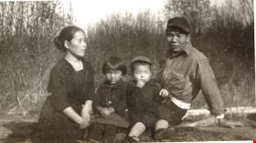
Tane, Sukegoro, Yasue and Harding Yasui
https://search.heritageburnaby.ca/link/museumdescription15212
- Repository
- Burnaby Village Museum
- Date
- 1926 (date of original), copied 2004
- Collection/Fonds
- In the Shadow by the Sea collection
- Description Level
- Item
- Physical Description
- 1 photograph (tiff) : 300 dpi
- Scope and Content
- Photograph of Tane (Hirata) Yasui and Sukegoro Yasui with their daughter, Yasue Margaret and son Harding Yasui. The family are seated on a log with a tall grass and bushes behind them.
- Repository
- Burnaby Village Museum
- Collection/Fonds
- In the Shadow by the Sea collection
- Description Level
- Item
- Physical Description
- 1 photograph (tiff) : 300 dpi
- Scope and Content
- Photograph of Tane (Hirata) Yasui and Sukegoro Yasui with their daughter, Yasue Margaret and son Harding Yasui. The family are seated on a log with a tall grass and bushes behind them.
- Geographic Access
- Burrard Inlet
- Accession Code
- BV019.32.32
- Access Restriction
- No restrictions
- Reproduction Restriction
- No known restrictions
- Date
- 1926 (date of original), copied 2004
- Media Type
- Photograph
- Historic Neighbourhood
- Barnet (Historic Neighbourhood)
- Planning Study Area
- Burnaby Mountain Area
- Notes
- Title based on contents of photograph
- See page 126 of book "In the Shadow by the Sea - Recollections of Burnaby's Barnet Village". Caption with photograph reads: "Mrs. Lane Yasui, Yasue, Harding and Mr. Sekagoro Yasui, 1926.
- In the Shadow by the Sea spells Sukegoro's wife's name as "Lane" (Harata) Yasui, obits for Sukegoro Yasui and his wife use the spelling "Tane" Hirata Yasui.
Images
Tarzan the terrible
https://search.heritageburnaby.ca/link/museumlibrary3442
- Repository
- Burnaby Village Museum
- Collection
- Special Collection
- Material Type
- Book
- Accession Code
- BV994.13.3
- Call Number
- 800 BUR
- Contributor
- St. John, J. Allen (James Allen), 1872-1957
- Place of Publication
- New York
- Publisher
- Grosset & Dunlap
- Publication Date
- 1921
- Physical Description
- 408, [1] p. : ill., map
- Library Subject (LOC)
- Fiction--20th century
- Notes
- frontispiece plus illustrations between p. 106 & p. 107 ; p. 170 & p. 171 and p. 234 & p. 235. fictional map p. 402

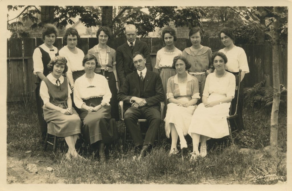
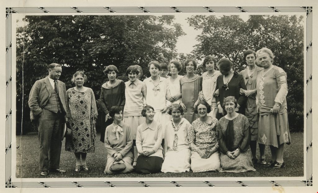
Teaching Staff at Kingsway West School
https://search.heritageburnaby.ca/link/museumdescription1322
- Repository
- Burnaby Village Museum
- Date
- June 1922
- Collection/Fonds
- Burnaby Village Museum Photograph collection
- Description Level
- Item
- Physical Description
- 1 photograph : b& w ; 10 x 15.5 cm
- Scope and Content
- Photograph of the teaching staff at Kingsway West School sitting and standing in two rows in front of a fence. Standing in the back row are (l to r); Miss Brice, Miss Morrow, Miss Brawn, Mr. Somerville, Miss Wells, Miss McGowan and Miss Wood. Seated in the front row (l to r); Miss Simpson, Miss Ann…
- Repository
- Burnaby Village Museum
- Collection/Fonds
- Burnaby Village Museum Photograph collection
- Description Level
- Item
- Physical Description
- 1 photograph : b& w ; 10 x 15.5 cm
- Scope and Content
- Photograph of the teaching staff at Kingsway West School sitting and standing in two rows in front of a fence. Standing in the back row are (l to r); Miss Brice, Miss Morrow, Miss Brawn, Mr. Somerville, Miss Wells, Miss McGowan and Miss Wood. Seated in the front row (l to r); Miss Simpson, Miss Annie Forrest, Mr. Brown, Miss Simmonds and Miss Gray.
- Subjects
- Occupations - Teachers
- Names
- Kingsway West School
- Forrest, Annie Theresa
- Brice, Miss
- Brown, Marie Cornelia Morrow
- Somerville, Chester Eugene
- Wells, Miss
- Simpson, Miss
- Brown, Mr
- Gray, Miss
- Geographic Access
- Kingsway
- Street Address
- 4800 Kingsway
- Accession Code
- BV999.2.10
- Access Restriction
- No restrictions
- Reproduction Restriction
- May be restricted by third party rights
- Date
- June 1922
- Media Type
- Photograph
- Historic Neighbourhood
- Central Park (Historic Neighbourhood)
- Planning Study Area
- Maywood Area
- Scan Resolution
- 600
- Scan Date
- 02-Jun-09
- Scale
- 100
- Photographer
- Bridgman's Studio Limited
- Notes
- Title based on contents of photograph
- Photographer's mark on verso of photograph reads: "Bridgman VANCOUVER"
- Note in black ink on verso of photograph reads: "June, 1922 / Left to right, Back row Misses Bure, Morrow, Brawn, Mr. Somerville, Misses Wells, McGowan, Wood / Front row. Misses Simpson, Forrest, Mr. Brown Misses Simmonds, Gray"
- Note in pencil on verso of photograph reads: "Teaching Staff Kingsway West"
Images
Teaching staff at Kingsway West School
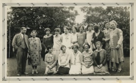
https://search.heritageburnaby.ca/link/museumdescription1360
- Repository
- Burnaby Village Museum
- Date
- 1929
- Collection/Fonds
- Burnaby Village Museum Photograph collection
- Description Level
- Item
- Physical Description
- 1 photograph : b&w ; 7.5 x 13.5 cm
- Scope and Content
- Photograph of Kingsway West School teaching staff outside on the school grounds. Standing in the back row (left to right) are; Mr. William D. Blair (principal), unidentified, Miss M. Bloomfield, Miss Edith Kay with Miss Annie Theresa Forrest partially visible behind her, Miss Daisy Bodley with Mis…
- Repository
- Burnaby Village Museum
- Collection/Fonds
- Burnaby Village Museum Photograph collection
- Description Level
- Item
- Physical Description
- 1 photograph : b&w ; 7.5 x 13.5 cm
- Material Details
- Decorative pattern printed along border of photograph
- Scope and Content
- Photograph of Kingsway West School teaching staff outside on the school grounds. Standing in the back row (left to right) are; Mr. William D. Blair (principal), unidentified, Miss M. Bloomfield, Miss Edith Kay with Miss Annie Theresa Forrest partially visible behind her, Miss Daisy Bodley with Miss Bert Thompson behind her shoulder, Miss Morgan, Miss Grimwood, Miss Doris Scott, unidentified, unidentified, unidentified. Kneeling in the front row (from left) are; Mrs. Cassie Roberts, Miss Dorothy Black, Miss Christine Goodman, unidentified, unidentified.
- Subjects
- Occupations - Teachers
- Names
- Kingsway West School
- Blair, William D
- Bloomfield, M.
- Kay, Edith
- Forrest, Annie Theresa
- Bodley, Daisy
- Thompson, Bert
- Morgan, Miss
- Grimwood, Miss
- Scott, Doris
- Roberts, Cassie
- Black, Dorothy
- Goodman, Christine
- Geographic Access
- Kingsway
- Street Address
- 4800 Kingsway
- Accession Code
- BV999.2.50
- Access Restriction
- No restrictions
- Reproduction Restriction
- May be restricted by third party rights
- Date
- 1929
- Media Type
- Photograph
- Historic Neighbourhood
- Central Park (Historic Neighbourhood)
- Planning Study Area
- Maywood Area
- Scan Resolution
- 600
- Scan Date
- 08-Jun-09
- Scale
- 100
- Notes
- Title based on contents of photograph
- Stamp on verso of photograph reads:"95 CRYSTAL/ FINISH"
Images
Tennyson's Idylls of the king
https://search.heritageburnaby.ca/link/museumlibrary1879
- Repository
- Burnaby Village Museum
- Collection
- Special Collection
- Material Type
- Book
- Accession Code
- HV982.24.15
- Call Number
- 821.8 TEN 1922
- Contributor
- French, Charles Wallace, 1858-1920
- Place of Publication
- New York
- Publisher
- Macmillan
- Publication Date
- 1922
- Series
- Macmillan's pocket classics
- Printer
- Norwood Press
- Physical Description
- xxiv, 434 p. : front ; 15 cm.
- Inscription
- Front endpaper: "Place stamp here" [written in pencil] "R.A. Pound 720 - Royal Ave New Westminster B.C. May 1 1925" [written in pencil] Back endpaper: "R.A.P. MB 60" [written in pencil] "Nixons Book Store New Westminster, B.C." [stamped in blue ink]
- Library Subject (LOC)
- English literature--Historical texts
- Poetry--historical texts
- Notes
- edited with introduction and notes by Charles W. French
- Includes index.
- Copy of book published in 1912 available.
Ten quadrilles for the pianoforte
https://search.heritageburnaby.ca/link/museumlibrary605
- Repository
- Burnaby Village Museum
- Author
- Albert, Charles d' 1809-1886
- Publication Date
- 1861
- Call Number
- 780 DAL
- Repository
- Burnaby Village Museum
- Collection
- Special Collection
- Material Type
- Book
- Accession Code
- BV985.209.1
- Call Number
- 780 DAL
- Author
- Albert, Charles d' 1809-1886
- Contributor
- Rimbault, Edward F. (Edward Francis), 1816-1876
- Place of Publication
- London
- Publisher
- Chappell & Co.
- Publication Date
- 1861
- Series
- Chappell's musical magazine
- Physical Description
- Rimbault, Edward F.
- Inscription
- "Beatrice Tate" [handwritten on page opposing front pastedown in black ink]
- Library Subject (LOC)
- Music
- Notes
- Author's full name and dates Charles Louis Napoléon d' Albert, 1809-1886.
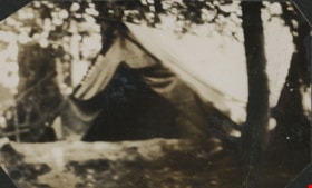
Tent at Boy Scout camp
https://search.heritageburnaby.ca/link/museumdescription20706
- Repository
- Burnaby Village Museum
- Date
- Aug. 1926
- Collection/Fonds
- David Geoffrey Llewellyn collection
- Description Level
- Item
- Physical Description
- 1 photograph : b&w ; 5.5 x 6 cm
- Scope and Content
- Photograph of tent at New Westminster District Boy Scout camp site at Granthams Landing.
- Repository
- Burnaby Village Museum
- Collection/Fonds
- David Geoffrey Llewellyn collection
- Description Level
- Item
- Physical Description
- 1 photograph : b&w ; 5.5 x 6 cm
- Scope and Content
- Photograph of tent at New Westminster District Boy Scout camp site at Granthams Landing.
- Names
- Boy Scouts of Canada
- Accession Code
- BV995.8.137
- Access Restriction
- No restrictions
- Reproduction Restriction
- No known restrictions
- Date
- Aug. 1926
- Media Type
- Photograph
- Scan Resolution
- 600
- Notes
- Title based on contents of photograph
- hotograph is part of photograph album BV995.8.1, pasted to page 40
Images

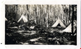
Tents at Granthams Landing camp
https://search.heritageburnaby.ca/link/museumdescription4908
- Repository
- Burnaby Village Museum
- Date
- Jul 1923
- Collection/Fonds
- Burnaby Girl Guides fonds
- Description Level
- Item
- Physical Description
- 1 photograph : b&w ; 7 x 11 cm
- Scope and Content
- Photograph of three white canvas tents in the woods at Granthams Landing.
- Repository
- Burnaby Village Museum
- Collection/Fonds
- Burnaby Girl Guides fonds
- Description Level
- Item
- Physical Description
- 1 photograph : b&w ; 7 x 11 cm
- Scope and Content
- Photograph of three white canvas tents in the woods at Granthams Landing.
- Names
- Girl Guides of Canada
- Accession Code
- BV015.35.266
- Access Restriction
- No restrictions
- Reproduction Restriction
- No known restrictions
- Date
- Jul 1923
- Media Type
- Photograph
- Scan Resolution
- 600
- Scan Date
- January 6, 2021
- Scale
- 100
- Notes
- Title based on contents of photograph
- Annotations in black ink on page of scrapbook reads: "Girl Guide Camp / Grantham's / Landing / July 1923"
- Note in pencil on verso of photograph reads: "867" (circled in pencil)
- Photograph is a part of scrapbook "Burnaby Girl Guides. -- [1914]-1969, predominant ca. 1920" (BV.015.35.164)
Images

Tents at Granthams Landing camp
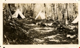
https://search.heritageburnaby.ca/link/museumdescription4910
- Repository
- Burnaby Village Museum
- Date
- Jul 1923
- Collection/Fonds
- Burnaby Girl Guides fonds
- Description Level
- Item
- Physical Description
- 1 photograph : sepia ; 7 x 11 cm
- Scope and Content
- Photograph of three white canvas tents in the woods at Granthams Landing.
- Repository
- Burnaby Village Museum
- Collection/Fonds
- Burnaby Girl Guides fonds
- Description Level
- Item
- Physical Description
- 1 photograph : sepia ; 7 x 11 cm
- Scope and Content
- Photograph of three white canvas tents in the woods at Granthams Landing.
- Names
- Girl Guides of Canada
- Accession Code
- BV015.35.268
- Access Restriction
- No restrictions
- Reproduction Restriction
- No known restrictions
- Date
- Jul 1923
- Media Type
- Photograph
- Scan Resolution
- 600
- Scan Date
- January 6, 2021
- Scale
- 100
- Notes
- Title based on contents of photograph
- Note in pencil on verso of photograph reads: "867" (circled in pencil)
- Annotations in black ink on page of scrapbook reads: "Girl Guide Camp / Grantham's / Landing / July 1923"
- Photograph is a part of scrapbook "Burnaby Girl Guides. -- [1914]-1969, predominant ca. 1920" (BV.015.35.164)
Images


Terrence Hannigan in a carriage
https://search.heritageburnaby.ca/link/museumdescription1194
- Repository
- Burnaby Village Museum
- Date
- 1923
- Collection/Fonds
- Burnaby Village Museum Photograph collection
- Description Level
- Item
- Physical Description
- 1 photograph : sepia ; 8 x 5.5 cm
- Scope and Content
- Photograph of Terrence Hannigan in a carriage on a wooden plank sidewalk beside Veteran's Grocery Store in the summer time.
- Repository
- Burnaby Village Museum
- Collection/Fonds
- Burnaby Village Museum Photograph collection
- Description Level
- Item
- Physical Description
- 1 photograph : sepia ; 8 x 5.5 cm
- Scope and Content
- Photograph of Terrence Hannigan in a carriage on a wooden plank sidewalk beside Veteran's Grocery Store in the summer time.
- Subjects
- Transportation - Carriages
- Names
- Hannigan, Terrence
- Geographic Access
- Kingsway
- Accession Code
- BV994.16.3
- Access Restriction
- No restrictions
- Reproduction Restriction
- No known restrictions
- Date
- 1923
- Media Type
- Photograph
- Historic Neighbourhood
- Central Park (Historic Neighbourhood)
- Scan Resolution
- 600
- Scan Date
- 2024-04-23
- Notes
- Title based on contents of photograph
- Note on verso of photograph reads: "Summer Kingsway 1923"
Images

![Terrence Hannigan in his pedal car, [1927] thumbnail](/media/hpo/_Data/_BVM_Images/1994/1994_0016_0001_001.jpg?width=280)
Terrence Hannigan in his pedal car
https://search.heritageburnaby.ca/link/museumdescription1192
- Repository
- Burnaby Village Museum
- Date
- [1927]
- Collection/Fonds
- Burnaby Village Museum Photograph collection
- Description Level
- Item
- Physical Description
- 1 photograph : sepia ; 6 x 10.5 cm
- Scope and Content
- Photograph of Terrence Hannigan in his pedal car in front of Central Park Theatre.
- Repository
- Burnaby Village Museum
- Collection/Fonds
- Burnaby Village Museum Photograph collection
- Description Level
- Item
- Physical Description
- 1 photograph : sepia ; 6 x 10.5 cm
- Scope and Content
- Photograph of Terrence Hannigan in his pedal car in front of Central Park Theatre.
- Subjects
- Toys
- Names
- Hannigan, Terrence
- Geographic Access
- Kingsway
- Accession Code
- BV994.16.1
- Access Restriction
- No restrictions
- Reproduction Restriction
- No known restrictions
- Date
- [1927]
- Media Type
- Photograph
- Historic Neighbourhood
- Central Park (Historic Neighbourhood)
- Scan Resolution
- 600
- Scan Date
- 2024-04-23
- Notes
- Title based on contents of photograph
Images
![Terrence Hannigan in his pedal car, [1927] thumbnail](/media/hpo/_Data/_BVM_Images/1994/1994_0016_0001_001.jpg)

Terrence Hannigan in his pedal car
https://search.heritageburnaby.ca/link/museumdescription1193
- Repository
- Burnaby Village Museum
- Date
- 1927
- Collection/Fonds
- Burnaby Village Museum Photograph collection
- Description Level
- Item
- Physical Description
- 1 photograph : sepia ; 10.5 x 6 cm
- Scope and Content
- Photograph of six year old Terrence Hannigan in his pedal car on the wooden plank sidewalk in front of Veteran's Grocery Store.
- Repository
- Burnaby Village Museum
- Collection/Fonds
- Burnaby Village Museum Photograph collection
- Description Level
- Item
- Physical Description
- 1 photograph : sepia ; 10.5 x 6 cm
- Scope and Content
- Photograph of six year old Terrence Hannigan in his pedal car on the wooden plank sidewalk in front of Veteran's Grocery Store.
- Subjects
- Toys
- Names
- Hannigan, Terrence
- Geographic Access
- Kingsway
- Accession Code
- BV994.16.2
- Access Restriction
- No restrictions
- Reproduction Restriction
- No known restrictions
- Date
- 1927
- Media Type
- Photograph
- Historic Neighbourhood
- Central Park (Historic Neighbourhood)
- Scan Resolution
- 600
- Scan Date
- 2024-04-23
- Notes
- Title based on contents of photograph
- Note on verso of photograph reads: "6 years"
- Stamp on verso of photograph reads: "IVORY FINISH 732"
Images

Test cricket: a unique record of England v. Australia matches (1877-1921)
https://search.heritageburnaby.ca/link/museumlibrary1557
- Repository
- Burnaby Village Museum
- Author
- Sparks, William P.H.
- Edition
- 2nd ed.
- Publication Date
- 1924
- Call Number
- 796.35875 SPA
- Repository
- Burnaby Village Museum
- Collection
- Special Collection
- Material Type
- Book
- Accession Code
- BV985.3856.1
- Call Number
- 796.35875 SPA
- Edition
- 2nd ed.
- Author
- Sparks, William P.H.
- Place of Publication
- London
- Publisher
- J. M. Ouseley & Son
- Publication Date
- 1924
- Printer
- Chance and Bland
- Physical Description
- ix, 198 p. ; 19 cm.
- Library Subject (LOC)
- Sports
- Notes
- Contains index.