Narrow Results By
![All Saints Church, [ca.1910] thumbnail](/media/hpo/_Data/_BVM_Cartographic_Material/2003/2003_0083_0046_001.jpg?width=280)
All Saints Church
https://search.heritageburnaby.ca/link/museumdescription11924
- Repository
- Burnaby Village Museum
- Date
- [ca.1910]
- Collection/Fonds
- Ronald G. Scobbie collection
- Description Level
- Item
- Physical Description
- 1 plan : black ink and watercol. on paper ; 30.45 x 30.5 cm
- Scope and Content
- Item consists of building insurance plan of "All Saints Church / Lot "A" BK 29 DL 98 GP1 N.W.D.". Watling Street is idenfied to the north of the church building and Royal Oak Avenue to the west.
- Repository
- Burnaby Village Museum
- Collection/Fonds
- Ronald G. Scobbie collection
- Description Level
- Item
- Physical Description
- 1 plan : black ink and watercol. on paper ; 30.45 x 30.5 cm
- Material Details
- Scale 1 inch = 20 feet
- Scope and Content
- Item consists of building insurance plan of "All Saints Church / Lot "A" BK 29 DL 98 GP1 N.W.D.". Watling Street is idenfied to the north of the church building and Royal Oak Avenue to the west.
- Subjects
- Buildings - Religious - Churches
- Accession Code
- BV003.83.46
- Access Restriction
- No restrictions
- Reproduction Restriction
- No known restrictions
- Date
- [ca.1910]
- Media Type
- Cartographic Material
- Scan Resolution
- 600
- Scan Date
- 15-Jan-2021
- Scale
- 100
- Notes
- Transcribed title
- Note in pencil on verso reads: ""All Saints Church / Lot "A" BK 29 DL 98 / Scale 1 inch = 20 feet"
- Note in balck in on verso reads: "3704"
Images
![All Saints Church, [ca.1910] thumbnail](/media/hpo/_Data/_BVM_Cartographic_Material/2003/2003_0083_0046_001.jpg)
![Anglican Church, [ca.1910] thumbnail](/media/hpo/_Data/_BVM_Cartographic_Material/2003/2003_0083_0043_001.jpg?width=280)
Anglican Church
https://search.heritageburnaby.ca/link/museumdescription11921
- Repository
- Burnaby Village Museum
- Date
- [ca.1910]
- Collection/Fonds
- Ronald G. Scobbie collection
- Description Level
- Item
- Physical Description
- 1 plan : black ink and watercol. on paper ; 30.45 x 30.5 cm
- Scope and Content
- Item consists of building insurance plan of "Anglican Church / Lot 2 BK 37 DL69, GP.1, N.W.D. (15th Ave. (Dominion) is identified to the north of Lots 1, 2 and 3).
- Repository
- Burnaby Village Museum
- Collection/Fonds
- Ronald G. Scobbie collection
- Description Level
- Item
- Physical Description
- 1 plan : black ink and watercol. on paper ; 30.45 x 30.5 cm
- Material Details
- Scale 1 inch = 20 feet
- Scope and Content
- Item consists of building insurance plan of "Anglican Church / Lot 2 BK 37 DL69, GP.1, N.W.D. (15th Ave. (Dominion) is identified to the north of Lots 1, 2 and 3).
- Subjects
- Buildings - Religious - Churches
- Accession Code
- BV003.83.43
- Access Restriction
- No restrictions
- Reproduction Restriction
- No known restrictions
- Date
- [ca.1910]
- Media Type
- Cartographic Material
- Scan Resolution
- 600
- Scan Date
- 15-Jan-2021
- Scale
- 100
- Notes
- Transcribed title
- Note in pencil on verso reads: "Anglican Church / Lot 2 Bk 37 DL69 / 1"=20' "
- Note in balck in on verso reads: "3704"
Images
![Anglican Church, [ca.1910] thumbnail](/media/hpo/_Data/_BVM_Cartographic_Material/2003/2003_0083_0043_001.jpg)
Application note re registration of plan of subdivision Block 7 of Lot 1 District Lot 25
https://search.heritageburnaby.ca/link/museumdescription18792
- Repository
- Burnaby Village Museum
- Date
- [190-]
- Collection/Fonds
- Love family fonds
- Description Level
- Item
- Physical Description
- 1 p. of textual records
- Scope and Content
- Item consists of a handwritten note on scrap of buff paper reading: "I hereby make application to register plan of subdivision of Blk 7 Lot I DL 25 NWG", signed "Jesse Love", "Registered owner".
- Repository
- Burnaby Village Museum
- Collection/Fonds
- Love family fonds
- Description Level
- Item
- Physical Description
- 1 p. of textual records
- Scope and Content
- Item consists of a handwritten note on scrap of buff paper reading: "I hereby make application to register plan of subdivision of Blk 7 Lot I DL 25 NWG", signed "Jesse Love", "Registered owner".
- Accession Code
- BV992.26.12
- Access Restriction
- No restrictions
- Reproduction Restriction
- No known restrictions
- Date
- [190-]
- Media Type
- Textual Record
- Notes
- Title based on contents of item
- Handwritten in ink on one side, paper is part of a form with pink ruled columns; verso of note reads: "Total Weekly Expenditure." at bottom right with dotted line and dollar sign, also "Previously returned.", "Total to date of this Return.", and "NOTE.-- This Form to be correctly filled in and forwarded weekly by first mail"; watermark is B.C. crest of flag and sun with "SPLENDOR SINE OCCASU" on banner
B.C. Leather Co. receipt
https://search.heritageburnaby.ca/link/museumdescription9748
- Repository
- Burnaby Village Museum
- Date
- Dec. 29 1909
- Collection/Fonds
- Hugh H. Stewart fonds
- Description Level
- Item
- Physical Description
- 1 textual record
- Scope and Content
- Item consists of one receipt from "B.C. Leather Co.", 112 Hastings Street West, Vancouver dated December 29, 1909. The receipt is made out to "H.H. Stewart" residing at 995 W. 7th Ave. Vancouver.
- Repository
- Burnaby Village Museum
- Collection/Fonds
- Hugh H. Stewart fonds
- Description Level
- Item
- Physical Description
- 1 textual record
- Scope and Content
- Item consists of one receipt from "B.C. Leather Co.", 112 Hastings Street West, Vancouver dated December 29, 1909. The receipt is made out to "H.H. Stewart" residing at 995 W. 7th Ave. Vancouver.
- Names
- Stewart, Hugh Henry
- Accession Code
- HV979.50.257
- Access Restriction
- No restrictions
- Reproduction Restriction
- No known restrictions
- Date
- Dec. 29 1909
- Media Type
- Textual Record
- Notes
- Title based on content of item
Births of Jesse and Martha Love
https://search.heritageburnaby.ca/link/museumdescription16926
- Repository
- Burnaby Village Museum
- Date
- 1879-1902
- Collection/Fonds
- Love family fonds
- Description Level
- Item
- Physical Description
- 1 p. : 24 x 30 cm
- Scope and Content
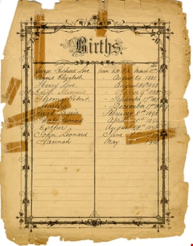
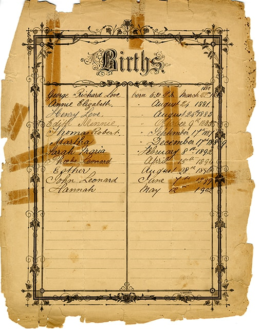
- Item consists of a births record page listing the children of Jesse and Martha Love. The page is presumed to be removed from a bible, potentially the Love family bible (BV992.26.1). The information on the obverse reads "Births / George Richard Love born 6:30 P.M March 22nd 1880 / Annie Elizabeth " …
- Repository
- Burnaby Village Museum
- Collection/Fonds
- Love family fonds
- Description Level
- Item
- Physical Description
- 1 p. : 24 x 30 cm
- Scope and Content
- Item consists of a births record page listing the children of Jesse and Martha Love. The page is presumed to be removed from a bible, potentially the Love family bible (BV992.26.1). The information on the obverse reads "Births / George Richard Love born 6:30 P.M March 22nd 1880 / Annie Elizabeth " August 24 1881 / Henry Love " August 24th 1883 / Edith Minnie " October 9th 1885 / Thomas Robert " September 17th 1887 / Martha "December 17th 1889 / Sarah Maria " February 8th 1892 / Phoebe Leonard April 15th 1894 / Esther August 28th 1896 / John Leonard June 7th 1899 / Hannah May 12th 1902". The reverse reads "Deaths" with no further notations.
- Accession Code
- BV992.26.30
- Access Restriction
- No restrictions
- Reproduction Restriction
- No known restrictions
- Date
- 1879-1902
- Media Type
- Textual Record
- Scan Resolution
- 600
- Scan Date
- 2022-06-10
- Notes
- Title based on the content of the page
Images
![Broadview Presbyterian Church, [ca.1910] thumbnail](/media/hpo/_Data/_BVM_Cartographic_Material/2003/2003_0083_0049_001.jpg?width=280)
Broadview Presbyterian Church
https://search.heritageburnaby.ca/link/museumdescription11927
- Repository
- Burnaby Village Museum
- Date
- [ca.1910]
- Collection/Fonds
- Ronald G. Scobbie collection
- Description Level
- Item
- Physical Description
- 1 plan : black ink and watercol. on paper ; 30.45 x 30.5 cm
- Scope and Content
- Item consists of building insurance plan of "Broadview Presbyterian Church / Lot 6, BK 31, DL 69 / GP1 N.W.D." . Fourteenth Avenue (Manor) is identified to the north and Douglas Ave. to the east.
- Repository
- Burnaby Village Museum
- Collection/Fonds
- Ronald G. Scobbie collection
- Description Level
- Item
- Physical Description
- 1 plan : black ink and watercol. on paper ; 30.45 x 30.5 cm
- Material Details
- Scale 1 inch = 20 feet
- Scope and Content
- Item consists of building insurance plan of "Broadview Presbyterian Church / Lot 6, BK 31, DL 69 / GP1 N.W.D." . Fourteenth Avenue (Manor) is identified to the north and Douglas Ave. to the east.
- Subjects
- Buildings - Religious - Churches
- Accession Code
- BV003.83.49
- Access Restriction
- No restrictions
- Reproduction Restriction
- No known restrictions
- Date
- [ca.1910]
- Media Type
- Cartographic Material
- Scan Resolution
- 600
- Scan Date
- 15-Jan-2021
- Scale
- 100
- Notes
- Transcribed title
- Note in pencil on verso reads: "Broadview Presbyterian Church / Lot 6, BK 31, DL 69 / 1" = 20' "
- Note in balck in on verso reads: "3704"
Images
![Broadview Presbyterian Church, [ca.1910] thumbnail](/media/hpo/_Data/_BVM_Cartographic_Material/2003/2003_0083_0049_001.jpg)
Certificate of vaccination
https://search.heritageburnaby.ca/link/museumdescription9727
- Repository
- Burnaby Village Museum
- Date
- Dec. 17 1900
- Collection/Fonds
- Hugh H. Stewart fonds
- Description Level
- Item
- Physical Description
- 1 textual record
- Scope and Content
- Item consists of one "Certificate of Vaccination" card for Hugh Stewart, child of D.H. Stewart, of the South Ward of the City of Nanaimo, B.C.
- Repository
- Burnaby Village Museum
- Collection/Fonds
- Hugh H. Stewart fonds
- Description Level
- Item
- Physical Description
- 1 textual record
- Scope and Content
- Item consists of one "Certificate of Vaccination" card for Hugh Stewart, child of D.H. Stewart, of the South Ward of the City of Nanaimo, B.C.
- Names
- Stewart, Hugh Henry
- Accession Code
- HV979.50.250
- Access Restriction
- Restricted access
- Reproduction Restriction
- Reproductions subject to FIPPA
- Date
- Dec. 17 1900
- Media Type
- Textual Record
- Notes
- Title based on content of item
Deed of Land between George A. Stevens and George Leonard re District Lot 352 South Vancouver
https://search.heritageburnaby.ca/link/museumdescription18783
- Repository
- Burnaby Village Museum
- Date
- 28 Mar. 1908
- Collection/Fonds
- Love family fonds
- Description Level
- Item
- Physical Description
- 1 p. of textual records
- Scope and Content
- Item consists of Deed of Land between George A. Stevens and George Leonard for South Vancouver Lots eleven (11) and twelve (12) of the Subdivision of Lots nine (9), ten (10), eleven (11), twelve (12) and thirteen (13) of Block sixteen (16) in District Lot 352.
- Repository
- Burnaby Village Museum
- Collection/Fonds
- Love family fonds
- Description Level
- Item
- Physical Description
- 1 p. of textual records
- Scope and Content
- Item consists of Deed of Land between George A. Stevens and George Leonard for South Vancouver Lots eleven (11) and twelve (12) of the Subdivision of Lots nine (9), ten (10), eleven (11), twelve (12) and thirteen (13) of Block sixteen (16) in District Lot 352.
- Accession Code
- BV992.26.3
- Access Restriction
- No restrictions
- Reproduction Restriction
- No known restrictions
- Date
- 28 Mar. 1908
- Media Type
- Textual Record
- Notes
- Title based on contents of item
- buff paper, legal-sized, with black print; pink borders; folds out.
- Front of folded cover reads: "Dated March 28th 1908 / George A. Stevens / TO / George Leonard / DEED OF LAND / SITUATE I / South Vancouver / AND BEING / Lots Eleven (11) & Twelve (12) SubDiv (9)(10)(11)(12)&(13) Bk. (16) & Lot (352)" "115.5 x 33 / EVANS & HASTINGS PRINTERS"
- Inside reads: "This Indenture.../ between George A. Stevens of the City of Vancouver.../ And / George Leonard.../ ...sum of eight hundred and fifty ($850) .../ ... Lots Eleven (11) & Twelve (12) of the Subdivision of Lots nine (9) Ten (10) Eleven (11) Twelve (12) and Thirteen (13) / of Block Sixteen (16) in DistLot-Three Hundred & / fifty two (352) Group one (1) New Westminster District..."
- signed by George Stevens twice, small red seals; witnessed twice by William Carter; "FOR MAKER" signed by William Carter, April 4, 1908; stamp seal "WILLIAM CARTER" "BRITISH COLUMBIA" "NOTARY PUBLIC"
Deed of land - estate of George Leonard to Martha Love
https://search.heritageburnaby.ca/link/museumdescription10085
- Repository
- Burnaby Village Museum
- Date
- 1909
- Collection/Fonds
- Love family fonds
- Description Level
- Item
- Physical Description
- 1 folder of textual records
- Scope and Content
- Item consists of a Deed of Land between the executors, "George Alfred Stevens and Edmund Evans" of the Will of George Leonard to Martha Love, dated August 5, 1909 re: Lots 11 and 12 in re-subdivision of Lots 9 to 13, Block 16, District Lot 352, Group One, Vancouver District.
- Repository
- Burnaby Village Museum
- Collection/Fonds
- Love family fonds
- Description Level
- Item
- Physical Description
- 1 folder of textual records
- Material Details
- "DATED August 1909 / GEORGE ALFRED STEVENS & / EDMUND EVANS / to / MARTHA LOVE. / DEED OF LAND / McLELLAN & SAVAGE.", printed on the outside fold of the page.
- Scope and Content
- Item consists of a Deed of Land between the executors, "George Alfred Stevens and Edmund Evans" of the Will of George Leonard to Martha Love, dated August 5, 1909 re: Lots 11 and 12 in re-subdivision of Lots 9 to 13, Block 16, District Lot 352, Group One, Vancouver District.
- History
- See extensive history of Love Family and Love farmhouse located at Burnaby Village Museum.
- Accession Code
- BV012.31.17
- Access Restriction
- No restrictions
- Reproduction Restriction
- No known restrictions
- Date
- 1909
- Media Type
- Textual Record
- Notes
- Title based on content of file
Document re payments, documents and release of mortgage
https://search.heritageburnaby.ca/link/museumdescription18805
- Repository
- Burnaby Village Museum
- Date
- 12 Dec. 1906
- Collection/Fonds
- Love family fonds
- Description Level
- Item
- Physical Description
- 1 p. of textual records
- Scope and Content
- Item consists of a handwritten document on letter head "Thomas R. Pearson / Fire Life & Accident Insurance..." signed by Jesse Love, addressed to T.R. Pearson re payment to James Armstrong or his agent F.W. Howay and delivery of documents in possession of F.W. Howay as well as pay out for release o…
- Repository
- Burnaby Village Museum
- Collection/Fonds
- Love family fonds
- Description Level
- Item
- Physical Description
- 1 p. of textual records
- Scope and Content
- Item consists of a handwritten document on letter head "Thomas R. Pearson / Fire Life & Accident Insurance..." signed by Jesse Love, addressed to T.R. Pearson re payment to James Armstrong or his agent F.W. Howay and delivery of documents in possession of F.W. Howay as well as pay out for release of mortgage.
- Accession Code
- BV992.26.25
- Access Restriction
- No restrictions
- Reproduction Restriction
- No known restrictions
- Date
- 12 Dec. 1906
- Media Type
- Textual Record
- Notes
- Title based on contents of item
- Document, very thin buff paper with black letterhead; at top in script, "Thomas R. Pearson," "Fire, Life & Accident Insurance." "Real Estate & Financial Broker."; engraving at left of four-leafed clover; "New Westminster, B.C."; handwritten in black ink, "12 Dec" "190" "6"; "To T.R. Pearson" "Please pay to Jas Armstrong or his Agent F.W. Howay the sum of $1013.00 and secure delivery of my documents in the possession of F W Howay, also pay out for release of mortgage", signed "Jesse Love"
![Dundonald United Church, [ca.1910] thumbnail](/media/hpo/_Data/_BVM_Cartographic_Material/2003/2003_0083_0052_001.jpg?width=280)
Dundonald United Church
https://search.heritageburnaby.ca/link/museumdescription11930
- Repository
- Burnaby Village Museum
- Date
- [ca.1910]
- Collection/Fonds
- Ronald G. Scobbie collection
- Description Level
- Item
- Physical Description
- 1 plan : black ink and watercol. on paper ; 30.45 x 30.5 cm
- Scope and Content
- Item consists of a building insurance plan of "Dundonald United Church / Lots 9, 10 BK 28 DL 159 GP 1 / N.W.D.". Clinton Street is identified to the north of Lots nine and ten.
- Repository
- Burnaby Village Museum
- Collection/Fonds
- Ronald G. Scobbie collection
- Description Level
- Item
- Physical Description
- 1 plan : black ink and watercol. on paper ; 30.45 x 30.5 cm
- Material Details
- Scale 1 inch = 20 feet
- Scope and Content
- Item consists of a building insurance plan of "Dundonald United Church / Lots 9, 10 BK 28 DL 159 GP 1 / N.W.D.". Clinton Street is identified to the north of Lots nine and ten.
- Subjects
- Buildings - Religious - Churches
- Names
- Dundonald United Church
- Accession Code
- BV003.83.52
- Access Restriction
- No restrictions
- Reproduction Restriction
- No known restrictions
- Date
- [ca.1910]
- Media Type
- Cartographic Material
- Scan Resolution
- 600
- Scan Date
- 15-Jan-2021
- Scale
- 100
- Notes
- Transcribed title
- Note in pencil on verso reads: "_ _Church / Lots 9 & 10 BK 28 DL 159 / 1" = 20' "
- Note in black ink on verso reads: "3704"
Images
![Dundonald United Church, [ca.1910] thumbnail](/media/hpo/_Data/_BVM_Cartographic_Material/2003/2003_0083_0052_001.jpg)
George Leonard estate list
https://search.heritageburnaby.ca/link/museumdescription10072
- Repository
- Burnaby Village Museum
- Date
- Apr. 9, 1909
- Collection/Fonds
- Love family fonds
- Description Level
- Item
- Physical Description
- 1 p. of textual records
- Scope and Content
- Item consists of a one page double sided handwritten document on a ledger page titled "George Leonard Estate (Deceased)" with a list of expenditures and receipts for the estate of George Leonard.
- Repository
- Burnaby Village Museum
- Collection/Fonds
- Love family fonds
- Description Level
- Item
- Physical Description
- 1 p. of textual records
- Material Details
- "McLellan, Savage / & White / Barristers __ / 337 Hastings St W." hand written on outside fold of document.
- Scope and Content
- Item consists of a one page double sided handwritten document on a ledger page titled "George Leonard Estate (Deceased)" with a list of expenditures and receipts for the estate of George Leonard.
- History
- See extensive history of Love Family and Love farmhouse located at Burnaby Village Museum.
- Accession Code
- BV012.31.4
- Access Restriction
- No restrictions
- Reproduction Restriction
- No known restrictions
- Date
- Apr. 9, 1909
- Media Type
- Textual Record
- Notes
- Title based on content of file
Land Registry certificate for maker of deed re G.A. Stevens and E. Evans
https://search.heritageburnaby.ca/link/museumdescription18800
- Repository
- Burnaby Village Museum
- Date
- 26 Oct. 1909
- Collection/Fonds
- Love family fonds
- Description Level
- Item
- Physical Description
- 1 p. of textual records
- Scope and Content
- Item consists of a Land Registry Act certificate for maker of a deed re G.A. Stevens & E. Evans signed by Notary Public, James Gill.
- Repository
- Burnaby Village Museum
- Collection/Fonds
- Love family fonds
- Description Level
- Item
- Physical Description
- 1 p. of textual records
- Scope and Content
- Item consists of a Land Registry Act certificate for maker of a deed re G.A. Stevens & E. Evans signed by Notary Public, James Gill.
- Accession Code
- BV992.26.20
- Access Restriction
- No restrictions
- Reproduction Restriction
- No known restrictions
- Date
- 26 Oct. 1909
- Media Type
- Textual Record
- Notes
- Title based on contents of item
- Certificate, blue paper, black print; "LAND REGISTRY ACT." "For Maker of a Deed."; dotted lines are filled in with handwriting in black ink; "I hereby certify that" "G.A. Stevens & E. Evans" "personally known to me, appeared before me and acknowledged to me that" "they are" "the persons mentioned in the annexed Instrument as the maker thereof, and whose names" "are" "subscribed thereto as part" "ies" ", that" "they" "know the contents thereof, and that" "they" "executed the same voluntarily, and" "are" "of the full age of twenty-one years." "IN TESTIMONY whereof, I have hereunto set my Hand and Seal of Office, at" "Vancouver, B.C." "this" "26th" "day of" "October" "in the year of Our Lord one thousand nine hundred and" "nine"; signed "James Gill", typed "A Notary Public in and for the Province of British Columbia."; typing is carbon; at lower left, "10,000/8/1909."; stamped round seal "JAMES GILL" "BRITISH COLUMBIA" "NOTARY PUBLIC".
![Map with subdivision of lots on Cumberland Road, [190-] thumbnail](/media/hpo/_Data/_BVM_Cartographic_Material/1992/1992_0026_0026_001.jpg?width=280)
Map with subdivision of lots on Cumberland Road
https://search.heritageburnaby.ca/link/museumdescription18806
- Repository
- Burnaby Village Museum
- Date
- [190-]
- Collection/Fonds
- Love family fonds
- Description Level
- Item
- Physical Description
- 1 map : hand drawn in graphite on paper ; 27.5 x 21 cm
- Scope and Content
- Item consists of a hand drawn map with subdivision lots labeled A,B,C,D,E,F along Cumberland Road.
- Repository
- Burnaby Village Museum
- Collection/Fonds
- Love family fonds
- Description Level
- Item
- Physical Description
- 1 map : hand drawn in graphite on paper ; 27.5 x 21 cm
- Scope and Content
- Item consists of a hand drawn map with subdivision lots labeled A,B,C,D,E,F along Cumberland Road.
- Accession Code
- BV992.26.26
- Access Restriction
- No restrictions
- Reproduction Restriction
- No known restrictions
- Date
- [190-]
- Media Type
- Cartographic Material
- Scan Resolution
- 600
- Scan Date
- 2022-06-10
- Notes
- Title based on contents of item
- Map, drawn by hand in pencil on brown paper; rectangle divided into lots A, B, C, D, E, F; all lots same size except B which is like a road or easement; "Cumberland Road" is written along one long side of block, "Parts Conveyed" written through lots; dimensions given; smaller drawing in corner of page with total dimensions of block, "1.", and note with arrow to block, "Registered sk of Mr. [sic] Loves see Map 813 Bd. 135"
Images
![Map with subdivision of lots on Cumberland Road, [190-] thumbnail](/media/hpo/_Data/_BVM_Cartographic_Material/1992/1992_0026_0026_001.jpg)
![Municipality of Burnaby, [ca. 1909] thumbnail](/media/hpo/_Data/_BVM_Cartographic_Material/1976/1976_0158_0006_002%20WEB.jpg?width=280)
Municipality of Burnaby
https://search.heritageburnaby.ca/link/museumdescription13095
- Repository
- Burnaby Village Museum
- Date
- [ca. 1909]
- Collection/Fonds
- Burnaby Village Museum Map collection
- Description Level
- Item
- Physical Description
- 1 map : b&w lithographic print on linen, b&w ; 40 x 43.5 cm
- Scope and Content
- Map of the Municipality of Burnaby issued by Mahon, McFarland and Mahon (Real Estate, Insurance and Loans, Vancouver B.C.). A handrawn red line runs south of Burnaby Lake and between North Road and Boundary Road.
- Repository
- Burnaby Village Museum
- Collection/Fonds
- Burnaby Village Museum Map collection
- Description Level
- Item
- Physical Description
- 1 map : b&w lithographic print on linen, b&w ; 40 x 43.5 cm
- Scope and Content
- Map of the Municipality of Burnaby issued by Mahon, McFarland and Mahon (Real Estate, Insurance and Loans, Vancouver B.C.). A handrawn red line runs south of Burnaby Lake and between North Road and Boundary Road.
- Creator
- Mahon, McFarland & Mahon
- Publisher
- The Angel Engraving Co.
- Accession Code
- HV976.158.6
- Access Restriction
- No restrictions
- Reproduction Restriction
- No known restrictions
- Date
- [ca. 1909]
- Media Type
- Cartographic Material
- Scan Resolution
- 420
- Scan Date
- Dec. 22, 2020
- Scale
- 100
- Notes
- Title based on content of map
- Title on map reads: "Map / of The / Municipality / of / BURNABY / ISSUED BY / Mahon, McFarland & Mahon"
- Map contains the initals "F.R.G." [sic]
- Circular insignia in left corner reads: "THE ANGEL ENGRAVING CO."
Zoomable Images
![Municipality of Burnaby, [ca. 1909] thumbnail](/media/hpo/_Data/_BVM_Cartographic_Material/1976/1976_0158_0006_001_seadragon/1976_0158_0006_001.jpg?w=280)

Sketch map of the Province of British Columbia showing mining divisions
https://search.heritageburnaby.ca/link/museumdescription18946
- Repository
- Burnaby Village Museum
- Date
- 1907
- Collection/Fonds
- Burnaby Village Museum Map collection
- Description Level
- Item
- Physical Description
- 1 map : col. lithographic print on paper ; 52 x 59 cm
- Scope and Content
- Item consists of a map titled "Sketch map of the Province of / British Columbia / Showing Mining Divisions"; "Department of Mines, / Victoria, 1907". Map includes wagon roads and trails and geographic disticts.
- Repository
- Burnaby Village Museum
- Collection/Fonds
- Burnaby Village Museum Map collection
- Description Level
- Item
- Physical Description
- 1 map : col. lithographic print on paper ; 52 x 59 cm
- Material Details
- Scale not determinable
- Scope and Content
- Item consists of a map titled "Sketch map of the Province of / British Columbia / Showing Mining Divisions"; "Department of Mines, / Victoria, 1907". Map includes wagon roads and trails and geographic disticts.
- Accession Code
- HV977.37.172
- Access Restriction
- No restrictions
- Reproduction Restriction
- No known restrictions
- Date
- 1907
- Media Type
- Cartographic Material
- Scan Resolution
- 600
- Scan Date
- 2023-08-17
- Notes
- Title based on contents of map
- Stamp on verso of map reads: "Compliments of Vancouver Tourist Bureau"
Zoomable Images

![St. Albans the Martyr, [ca.1910] thumbnail](/media/hpo/_Data/_BVM_Cartographic_Material/2003/2003_0083_0048_001.jpg?width=280)
St. Albans the Martyr
https://search.heritageburnaby.ca/link/museumdescription11926
- Repository
- Burnaby Village Museum
- Date
- [ca.1910]
- Collection/Fonds
- Ronald G. Scobbie collection
- Description Level
- Item
- Physical Description
- 1 plan : black ink and watercol. on paper ; 30.45 x 30.5 cm
- Scope and Content
- Item consists of building insurance plan of "St. Albans the Martyr / Lots 45 & 46 North Part DL 28 / GP1 N.W.D." Edmonds Street is to the north, Douglas Road to the west and 19th Avenue to the south.
- Repository
- Burnaby Village Museum
- Collection/Fonds
- Ronald G. Scobbie collection
- Description Level
- Item
- Physical Description
- 1 plan : black ink and watercol. on paper ; 30.45 x 30.5 cm
- Material Details
- Scale 1 inch = 40 feet
- Scope and Content
- Item consists of building insurance plan of "St. Albans the Martyr / Lots 45 & 46 North Part DL 28 / GP1 N.W.D." Edmonds Street is to the north, Douglas Road to the west and 19th Avenue to the south.
- Subjects
- Buildings - Religious - Churches
- Accession Code
- BV003.83.48
- Access Restriction
- No restrictions
- Reproduction Restriction
- No known restrictions
- Date
- [ca.1910]
- Media Type
- Cartographic Material
- Scan Resolution
- 600
- Scan Date
- 15-Jan-2021
- Scale
- 100
- Notes
- Transcribed title
- Note in pencil on verso reads: "St. Albans the Martyr / Lots 45 & 46 North Part DL 28 / 1" = 40' "
- Note in balck in on verso reads: "3704"
Images
![St. Albans the Martyr, [ca.1910] thumbnail](/media/hpo/_Data/_BVM_Cartographic_Material/2003/2003_0083_0048_001.jpg)
![St. Helen's Church, [ca.1910] thumbnail](/media/hpo/_Data/_BVM_Cartographic_Material/2003/2003_0083_0051_001.jpg?width=280)
St. Helen's Church
https://search.heritageburnaby.ca/link/museumdescription11929
- Repository
- Burnaby Village Museum
- Date
- [ca.1910]
- Collection/Fonds
- Ronald G. Scobbie collection
- Description Level
- Item
- Physical Description
- 1 plan : black ink and watercol. on paper ; 30.45 x 30.5 cm
- Scope and Content
- Item consists of building insurance plan of "St. Helen's Church / Lots 11 & 12 BK 7 DL 186 / GP1 N.W.D." . Ingleton Ave is identified to the east and Pandora St. to the south.
- Repository
- Burnaby Village Museum
- Collection/Fonds
- Ronald G. Scobbie collection
- Description Level
- Item
- Physical Description
- 1 plan : black ink and watercol. on paper ; 30.45 x 30.5 cm
- Material Details
- Scale 1 inch = 20 feet
- Scope and Content
- Item consists of building insurance plan of "St. Helen's Church / Lots 11 & 12 BK 7 DL 186 / GP1 N.W.D." . Ingleton Ave is identified to the east and Pandora St. to the south.
- Subjects
- Buildings - Religious - Churches
- Accession Code
- BV003.83.51
- Access Restriction
- No restrictions
- Reproduction Restriction
- No known restrictions
- Date
- [ca.1910]
- Media Type
- Cartographic Material
- Scan Resolution
- 600
- Scan Date
- 15-Jan-2021
- Scale
- 100
- Notes
- Transcribed title
- Note in pencil on verso reads: ""St. Helen's Church / Lots 11 & 12 BK 7 DL 186 / 1" = 20' "
- Note in balck in on verso reads: "3704"
Images
![St. Helen's Church, [ca.1910] thumbnail](/media/hpo/_Data/_BVM_Cartographic_Material/2003/2003_0083_0051_001.jpg)
![St. John the Divine, [ca.1910] thumbnail](/media/hpo/_Data/_BVM_Cartographic_Material/2003/2003_0083_0044_001.jpg?width=280)
St. John the Divine
https://search.heritageburnaby.ca/link/museumdescription11922
- Repository
- Burnaby Village Museum
- Date
- [ca.1910]
- Collection/Fonds
- Ronald G. Scobbie collection
- Description Level
- Item
- Physical Description
- 1 plan : black ink and watercol. on paper ; 30.45 x 30.5 cm
- Scope and Content
- Item consists of building insurance plan of "St. John the Divine / Lot "A" BK. 49 DL 35 GP1 N.W.D.". Kingsway is identified to the south of building.
- Repository
- Burnaby Village Museum
- Collection/Fonds
- Ronald G. Scobbie collection
- Description Level
- Item
- Physical Description
- 1 plan : black ink and watercol. on paper ; 30.45 x 30.5 cm
- Material Details
- Scale 1 inch = 20 feet
- Scope and Content
- Item consists of building insurance plan of "St. John the Divine / Lot "A" BK. 49 DL 35 GP1 N.W.D.". Kingsway is identified to the south of building.
- Subjects
- Buildings - Religious - Churches
- Accession Code
- BV003.83.44
- Access Restriction
- No restrictions
- Reproduction Restriction
- No known restrictions
- Date
- [ca.1910]
- Media Type
- Cartographic Material
- Scan Resolution
- 600
- Scan Date
- 15-Jan-2021
- Scale
- 100
- Notes
- Transcribed title
- Note in pencil on verso reads: "St. John the Divine / Lot "A" BK. 49 DL 35 / 1"=20' "
- Note in balck in on verso reads: "3704"
Images
![St. John the Divine, [ca.1910] thumbnail](/media/hpo/_Data/_BVM_Cartographic_Material/2003/2003_0083_0044_001.jpg)
![Survey plan of District Lot 25, [190-] thumbnail](/media/hpo/_Data/_BVM_Cartographic_Material/1992/1992_0026_0027_001.jpg?width=280)
Survey plan of District Lot 25
https://search.heritageburnaby.ca/link/museumdescription18807
- Repository
- Burnaby Village Museum
- Date
- [190-]
- Collection/Fonds
- Love family fonds
- Description Level
- Item
- Physical Description
- 1 plan : black ink on linen ; 23 x 14 cm
- Scope and Content
- Item consists of a survey plan created by Provincial Land Surveyor Albert J. Hill with lots numbered one to six of District Lot 25, Lot 6 noted as owned by "Debeck", next to lot no. owned by "Newcombe", Lots numbered 11 to 13 on the other side of Cumberland Street.
- Repository
- Burnaby Village Museum
- Collection/Fonds
- Love family fonds
- Description Level
- Item
- Physical Description
- 1 plan : black ink on linen ; 23 x 14 cm
- Scope and Content
- Item consists of a survey plan created by Provincial Land Surveyor Albert J. Hill with lots numbered one to six of District Lot 25, Lot 6 noted as owned by "Debeck", next to lot no. owned by "Newcombe", Lots numbered 11 to 13 on the other side of Cumberland Street.
- Creator
- Hill, Albert James
- Accession Code
- BV992.26.27
- Access Restriction
- No restrictions
- Reproduction Restriction
- No known restrictions
- Date
- [190-]
- Media Type
- Cartographic Material
- Notes
- Title based on contents of item
- Map: hand-drawn in black ink on small rectangle of linen; shows area of "CITY, SUBURBAN.", by Albert J. Hill, P.L.S.; Tenth Avenue, Third Avenue, Armstrong Street, Cumberland Street; lots 1-6 of L.25, dimensions given; L.6 is owned by "Debeck", next lot no number by "Newcombe"; lots 11 and 13 on other side of Cumberland St.; signature J.C. Armstrong; "4" in circle; L.1 is subdivided with pencilled lines
Images
![Survey plan of District Lot 25, [190-] thumbnail](/media/hpo/_Data/_BVM_Cartographic_Material/1992/1992_0026_0027_001.jpg)