Narrow Results By
Subject
- Aerial Photographs 1
- Animals - Dogs 5
- Buildings - Civic - Fire Halls 3
- Buildings - Civic - Libraries 2
- Buildings - Commercial - Grocery Stores 1
- Buildings - Commercial - Hardware Stores 2
- Buildings - Commercial - Service Stations 1
- Buildings - Commercial - Stores 1
- Buildings - Industrial - Mills 1
- Buildings - Religious - Churches 2
- Buildings - Residential 1
- Buildings - Residential - Houses 10

Frank Walsh Residence
https://search.heritageburnaby.ca/link/landmark581
- Repository
- Burnaby Heritage Planning
- Description
- Residential building.
- Associated Dates
- 1948
- Street View URL
- Google Maps Street View
- Repository
- Burnaby Heritage Planning
- Geographic Access
- Boundary Road
- Associated Dates
- 1948
- Description
- Residential building.
- Heritage Value
- This Streamline Moderne house is a rare example of this style in Burnaby and remains in excellent condition. Reflecting the influence of technology, industrial design and aerodynamic styling, the house has smooth rounded surfaces, rounded corners, a flat roof and prominent projecting eaves. It was built for prominent North Burnaby businessman Frank Wallace Walsh (1907-1963), who was a mechanic, and his wife Rena.
- Locality
- Vancouver Heights
- Historic Neighbourhood
- Vancouver Heights (Historic Neighbourhood)
- Planning Study Area
- Burnaby Heights Area
- Area
- 566.71
- Contributing Resource
- Building
- Ownership
- Private
- Street Address
- 270 Boundary Road
- Street View URL
- Google Maps Street View
Images


Vancouver Heights Neighbourhood
https://search.heritageburnaby.ca/link/landmark666
- Repository
- Burnaby Heritage Planning
- Associated Dates
- 1925-1954
- Heritage Value
- Vancouver Heights remained an important residential and commercial centre in Burnaby throughout the 1925-1954 period. The area had its own Board of Trade and the North Burnaby Library was created to serve the residents. In 1949, the Hastings streetcars stopped running, but the area retained its reputation as one of the best shopping districts in the city.
- Historic Neighbourhood
- Vancouver Heights (Historic Neighbourhood)
- Planning Study Area
- Burnaby Heights Area
Images


Crabtown
https://search.heritageburnaby.ca/link/landmark674
- Repository
- Burnaby Heritage Planning
- Associated Dates
- 1912-1957
- Heritage Value
- North Burnaby's waterfront was the location of a unique squatter's community known as Crabtown. Although its origins are obscure, it is believed that the first shacks were built before 1912. When the depression of 1913-1917 began, the shacks became permanent homes for impoverished workers. During the Great Depression of the 1930s, the community grew larger. Crabtown was not a slum, but a neighbourhood - the community even rallied together to build a water supply system and trails up the steep bluff with steps and banisters so children could go to school safely. In 1957, the National Harbours Board decided that Crabtown was encroaching on Federal property and evicted all 130 residents. Within a few months, residents were relocated and 114 homes were levelled.
- Historic Neighbourhood
- Vancouver Heights (Historic Neighbourhood)
- Planning Study Area
- Burnaby Heights Area
Images

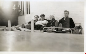
Firefighters Harry Anderson, Leo Fraser, Fred Blake and Henry Chapman
https://search.heritageburnaby.ca/link/museumdescription2625
- Repository
- Burnaby Village Museum
- Date
- 1940
- Collection/Fonds
- Burnaby Village Museum Photograph collection
- Description Level
- Item
- Physical Description
- 1 photograph : b&w ; 6 x 10.5 cm
- Scope and Content
- Photograph of Firefighters Harry Anderson, Leo Fraser, Fred Blake and Henry Chapman lying down on their beds in the dormitory at No. 1 Burnaby Fire Hall at Carleton Avenue and Eton Street. This photograph was taken by Fred Blake using a box camera with a five minute exposure (so that he was able to…
- Repository
- Burnaby Village Museum
- Collection/Fonds
- Burnaby Village Museum Photograph collection
- Description Level
- Item
- Physical Description
- 1 photograph : b&w ; 6 x 10.5 cm
- Scope and Content
- Photograph of Firefighters Harry Anderson, Leo Fraser, Fred Blake and Henry Chapman lying down on their beds in the dormitory at No. 1 Burnaby Fire Hall at Carleton Avenue and Eton Street. This photograph was taken by Fred Blake using a box camera with a five minute exposure (so that he was able to run and put himself into the shot before the shutter closed).
- Geographic Access
- Carleton Avenue
- Eton Street
- Accession Code
- BV002.75.6
- Access Restriction
- Restricted access
- Reproduction Restriction
- May be restricted by third party rights
- Date
- 1940
- Media Type
- Photograph
- Historic Neighbourhood
- Vancouver Heights (Historic Neighbourhood)
- Planning Study Area
- Burnaby Heights Area
- Scan Resolution
- 600
- Scan Date
- 1/12/2010
- Scale
- 100
- Photographer
- Blake, Frederick "Fred"
- Notes
- Title based on contents of photograph
- Quote from letter of Aug. 15, 2002 from Fred Blake (letter in accession file): "With reference to the enclosed picture where I am stretched out on the bed. All my early pictures were taken with a box camera that I still have. With the slow film and poor room lighting I knew it would have to be a five minute time exposure. There was no automatic timer on the box camera. You had to press the shutter button to open the lens and again to close it. With this length of exposure I knew that if I moved quickly I could be in the picture. I had the others propped up and opened the lens and ran across and took my place on the bed. When I fell back I realized that I had forgotten a back rest for myself. I stayed that way for five minutes as I didn't want to take a chance of spoiling the picture. When the time was up I ran across the room and closed the lens. I was pleased that the picture tuned out alright, but a little disappointed about me."
- Handwritten note on verso of photograph reads: "I had to hang on to FRASER so that I wouldn't fall off the bed. / 658X / 1940 No.1 HALL 290 N. CARLETON / HARRY ANDERSON LEO FRASER FRED BLAKE HENRY CHAPMAN / L TO R"
Images
![Municipality of Burnaby - Volume XV and Volume XVIII, 1927-[1940] thumbnail](/media/hpo/_Data/_BVM_Artifacts/1972/1972_0111_0004_003.jpg?width=280)
Municipality of Burnaby - Volume XV and Volume XVIII
https://search.heritageburnaby.ca/link/museumdescription8682
- Repository
- Burnaby Village Museum
- Date
- 1927-[1940]
- Collection/Fonds
- Burnaby Village Museum Map collection
- Description Level
- File
- Physical Description
- 4 plans on 4 sheets: col. lithographic prints ; 63.5 x 53.5 cm folded to 53 x 31.5 cm
- Scope and Content
- File consists of four pages of plans removed from a bound book containing a series of fire insurance plans of the Municipality of Burnaby. Plan "1518" and "1519" are from "GREATER VANCOUVER B.C. / VOLUME XV / Municipality of Burnaby / May, 1927". Plan "1518" covers District Lot 116 and Plan "1519"…
- Repository
- Burnaby Village Museum
- Collection/Fonds
- Burnaby Village Museum Map collection
- Description Level
- File
- Physical Description
- 4 plans on 4 sheets: col. lithographic prints ; 63.5 x 53.5 cm folded to 53 x 31.5 cm
- Material Details
- Scale [1:600]
- Scope and Content
- File consists of four pages of plans removed from a bound book containing a series of fire insurance plans of the Municipality of Burnaby. Plan "1518" and "1519" are from "GREATER VANCOUVER B.C. / VOLUME XV / Municipality of Burnaby / May, 1927". Plan "1518" covers District Lot 116 and Plan "1519" covers District Lot 121. Plan "1802" and plan "1803" are from "GREATER VANCOUVER B.C. / VOLUME XVIII / Municipality of Burnaby / May, 1927". Both plans "1802" and "1803" cover District Lot 153.
- Responsibility
- British Columbia Underwriters' Association
- Accession Code
- HV972.111.4
- Access Restriction
- No restrictions
- Reproduction Restriction
- May be restricted by third party rights
- Date
- 1927-[1940]
- Media Type
- Cartographic Material
- Historic Neighbourhood
- Vancouver Heights (Historic Neighbourhood)
- Central Park (Historic Neighbourhood)
- Planning Study Area
- Willingdon Heights Area
- Marlborough Area
- Scan Resolution
- 400
- Scan Date
- 2021-11-18
- Notes
- Title based on content of plans
- See also BV987.1.70d for revised versions of plans
- Scale is measured 1 inch = 50 feet
- Contact Burnaby Village Museum to access plans 1518 and 1519 (these plans have revisions on top - date of revisions is uncertain)
Images
![Municipality of Burnaby - Volume XV and Volume XVIII, 1927-[1940] thumbnail](/media/hpo/_Data/_BVM_Artifacts/1972/1972_0111_0004_003.jpg)

![Members of the Knight family under tree, [194-] thumbnail](/media/hpo/_Data/_BVM_Images/2020/2020_0034_0023_001.jpg?width=280)
Members of the Knight family under tree
https://search.heritageburnaby.ca/link/museumdescription15334
- Repository
- Burnaby Village Museum
- Date
- [194-]
- Collection/Fonds
- Margaret Norton fonds
- Description Level
- Item
- Physical Description
- 1 photograph : sepia ; 9 x 6.5 cm
- Scope and Content
- Photograph of members of the Knight family (left to right) Naida Hansen (nee Knight), Dolly Walker-Kirkwood (nee Knight), Fred Knight and Lila McKinley (nee Knight) and Margaret Norton (nee Knight) (cut off). The group have their arms around each other and are standing under a willow tree in the ya…
- Repository
- Burnaby Village Museum
- Collection/Fonds
- Margaret Norton fonds
- Description Level
- Item
- Physical Description
- 1 photograph : sepia ; 9 x 6.5 cm
- Scope and Content
- Photograph of members of the Knight family (left to right) Naida Hansen (nee Knight), Dolly Walker-Kirkwood (nee Knight), Fred Knight and Lila McKinley (nee Knight) and Margaret Norton (nee Knight) (cut off). The group have their arms around each other and are standing under a willow tree in the yard of the family home at 931 Gilmore Avenue.
- Names
- Norton, Margaret Knight
- Hansen, Naida Knight
- Knight, Frederick "Fred"
- Walker-Kirkwood, Dolly Knight
- McKinley, Lila Knight
- Geographic Access
- Gilmore Avenue
- Street Address
- 931 Gilmore Avenue
- Accession Code
- BV020.34.23
- Access Restriction
- No restrictions
- Reproduction Restriction
- No known restrictions
- Date
- [194-]
- Media Type
- Photograph
- Historic Neighbourhood
- Vancouver Heights (Historic Neighbourhood)
- Planning Study Area
- Willingdon Heights Area
- Scan Resolution
- 600
- Scan Date
- March 22, 2021
- Scale
- 100
- Notes
- Title based on contents of photograph
Images
![Members of the Knight family under tree, [194-] thumbnail](/media/hpo/_Data/_BVM_Images/2020/2020_0034_0023_001.jpg)
![Louise Knight and her five children, [194-] thumbnail](/media/hpo/_Data/_BVM_Images/2020/2020_0034_0025_001.jpg?width=280)
Louise Knight and her five children
https://search.heritageburnaby.ca/link/museumdescription15336
- Repository
- Burnaby Village Museum
- Date
- [194-]
- Collection/Fonds
- Margaret Norton fonds
- Description Level
- Item
- Physical Description
- 1 photograph : sepia ; 8.5 x 6 cm
- Scope and Content
- Photograph of Louise Knight (nee Ellis) together with her five grown children under a willow tree in the yard of the Knight-Roberts family home located at 931 Gilmore Avenue. From left to right (back row): Naida Hansen (nee Knight), Fred Knight, Lila McKinley (nee Knight). From left to right (front…
- Repository
- Burnaby Village Museum
- Collection/Fonds
- Margaret Norton fonds
- Description Level
- Item
- Physical Description
- 1 photograph : sepia ; 8.5 x 6 cm
- Scope and Content
- Photograph of Louise Knight (nee Ellis) together with her five grown children under a willow tree in the yard of the Knight-Roberts family home located at 931 Gilmore Avenue. From left to right (back row): Naida Hansen (nee Knight), Fred Knight, Lila McKinley (nee Knight). From left to right (front row): Dolly Dolly Walker-Kirkwood (nee Knight) , Louise Knight (nee Ellis) and Margaret Norton (nee Knight).
- Names
- Norton, Margaret Knight
- Hansen, Naida Knight
- McKinley, Lila Knight
- Walker-Kirkwood, Dolly Knight
- Knight, Frederick "Fred"
- Knight, Louise Ellis
- Geographic Access
- Gilmore Avenue
- Street Address
- 931 Gilmore Avenue
- Accession Code
- BV020.34.25
- Access Restriction
- No restrictions
- Reproduction Restriction
- No known restrictions
- Date
- [194-]
- Media Type
- Photograph
- Historic Neighbourhood
- Vancouver Heights (Historic Neighbourhood)
- Scan Resolution
- 600
- Scan Date
- March 22, 2021
- Scale
- 100
- Notes
- Title based on contents of photograph
Images
![Louise Knight and her five children, [194-] thumbnail](/media/hpo/_Data/_BVM_Images/2020/2020_0034_0025_001.jpg)
![Margaret Norton and Fred Knight, [194-] thumbnail](/media/hpo/_Data/_BVM_Images/2020/2020_0034_0033_001.jpg?width=280)
Margaret Norton and Fred Knight
https://search.heritageburnaby.ca/link/museumdescription15344
- Repository
- Burnaby Village Museum
- Date
- [194-]
- Collection/Fonds
- Margaret Norton fonds
- Description Level
- Item
- Physical Description
- 1 photograph : sepia ; 18 x 12.5 cm
- Scope and Content
- Photograph of Margaret Norton (nee Knight) standing together with her twin brother Fred Knight. They each have one arm wrapped around each other's backs and are standing in front of a willow tree.
- Repository
- Burnaby Village Museum
- Collection/Fonds
- Margaret Norton fonds
- Description Level
- Item
- Physical Description
- 1 photograph : sepia ; 18 x 12.5 cm
- Scope and Content
- Photograph of Margaret Norton (nee Knight) standing together with her twin brother Fred Knight. They each have one arm wrapped around each other's backs and are standing in front of a willow tree.
- Geographic Access
- Gilmore Avenue
- Street Address
- 931 Gilmore Avenue
- Accession Code
- BV020.34.33
- Access Restriction
- No restrictions
- Reproduction Restriction
- No known restrictions
- Date
- [194-]
- Media Type
- Photograph
- Historic Neighbourhood
- Vancouver Heights (Historic Neighbourhood)
- Scan Resolution
- 600
- Scan Date
- March 22, 2021
- Scale
- 100
- Notes
- Title based on contents of photograph
- Note in blue ink on verso of photograph reads: "Nice of You but haven't I that beartcat / look"
Images
![Margaret Norton and Fred Knight, [194-] thumbnail](/media/hpo/_Data/_BVM_Images/2020/2020_0034_0033_001.jpg)
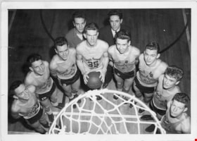
Burnaby South High School basketball team
https://search.heritageburnaby.ca/link/museumdescription15355
- Repository
- Burnaby Village Museum
- Date
- 1945 (date of original), copied 2020
- Collection/Fonds
- Burnaby Village Museum Photograph collection
- Description Level
- Item
- Physical Description
- 1 photograph (tiff) : b&w ; 1200 dpi
- Scope and Content
- Photograph of the Burnaby South Highschool basketball team. Members of the team are gathered around a basketball net in the school gymnasium. Team manager, Lavergne "Vern" Hurley is standing in the back row (left) next to coach, Terry Julian (right). Basketball players are identified as: Ken Swalwe…
- Repository
- Burnaby Village Museum
- Collection/Fonds
- Burnaby Village Museum Photograph collection
- Description Level
- Item
- Physical Description
- 1 photograph (tiff) : b&w ; 1200 dpi
- Scope and Content
- Photograph of the Burnaby South Highschool basketball team. Members of the team are gathered around a basketball net in the school gymnasium. Team manager, Lavergne "Vern" Hurley is standing in the back row (left) next to coach, Terry Julian (right). Basketball players are identified as: Ken Swalwell (#35- holding basketball); Bill Popowich (#10-third from right); David Cordis (#8-fourth from right) and Fred Forshaw (far right), other players are unidentified. The photograph has been taken from above the basketball court.
- Names
- Burnaby South High School
- Hurley, Lavergne "Vern"
- Julian, Terry
- Swalwell, Ken
- Popowich, Bill
- Cordis, Dave
- Forshaw, Fred
- Geographic Access
- Pandora Street
- Street Address
- 4375 Pandora Street
- Accession Code
- BV020.39.1
- Access Restriction
- No restrictions
- Reproduction Restriction
- May be restricted by third party rights
- Date
- 1945 (date of original), copied 2020
- Media Type
- Photograph
- Historic Neighbourhood
- Vancouver Heights (Historic Neighbourhood)
- Planning Study Area
- Burnaby Heights Area
- Scan Resolution
- 600
- Scan Date
- March 25, 2021
- Scale
- 100
- Photographer
- Henderson, Norman "Norm"
- Notes
- Title based on contents of photograph
- Stamp on verso of photograph reads: "Photograph by / Norman M. Henderson"
Images
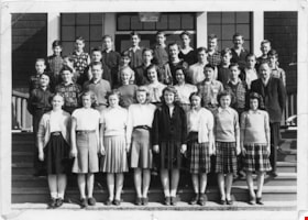
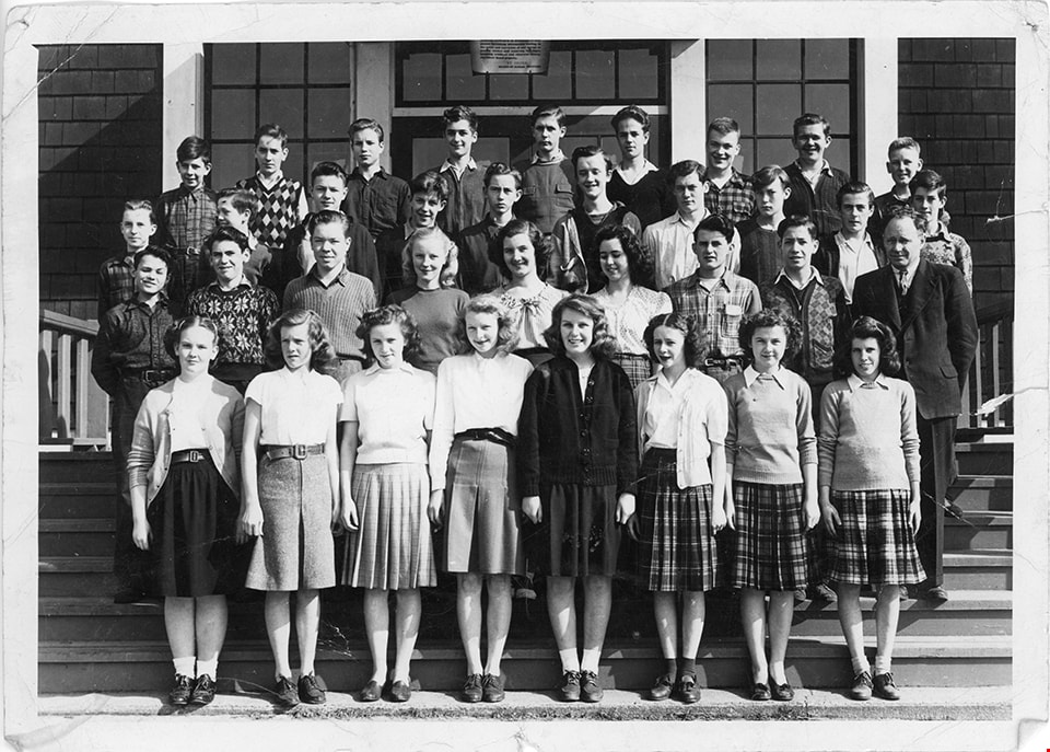
Burnaby South High School students
https://search.heritageburnaby.ca/link/museumdescription15356
- Repository
- Burnaby Village Museum
- Date
- 1945 (date of original), copied 2020
- Collection/Fonds
- Burnaby Village Museum Photograph collection
- Description Level
- Item
- Physical Description
- 1 photograph (tiff) : b&w ; 1200 dpi
- Scope and Content
- Photograph of students at Burnaby South Highschool. Students in front row include; Shirley Garett, Jean (Ranger) Penzer, Rae Milton and Margaret Farrand [sic] and Jean Wellsby (far right). Students in the second row include: Rogers and Bigham. Lavergne "Vern" Hurley is identified in back row (fourt…
- Repository
- Burnaby Village Museum
- Collection/Fonds
- Burnaby Village Museum Photograph collection
- Description Level
- Item
- Physical Description
- 1 photograph (tiff) : b&w ; 1200 dpi
- Scope and Content
- Photograph of students at Burnaby South Highschool. Students in front row include; Shirley Garett, Jean (Ranger) Penzer, Rae Milton and Margaret Farrand [sic] and Jean Wellsby (far right). Students in the second row include: Rogers and Bigham. Lavergne "Vern" Hurley is identified in back row (fourth from right).
- Subjects
- Buildings - Schools
- Persons - Students
- Geographic Access
- Pandora Street
- Street Address
- 4375 Pandora Street
- Accession Code
- BV020.39.2
- Access Restriction
- No restrictions
- Reproduction Restriction
- No known restrictions
- Date
- 1945 (date of original), copied 2020
- Media Type
- Photograph
- Historic Neighbourhood
- Vancouver Heights (Historic Neighbourhood)
- Planning Study Area
- Burnaby Heights Area
- Scan Resolution
- 600
- Scan Date
- March 25, 2021
- Scale
- 100
- Notes
- Title based on contents of photograph
- Note in black ink on verso of original photograph reads: "Front Row: Shirley Garett / Jean Ranger / Rae Milton / Margaret Farrand [sic]"
Images
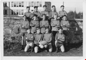
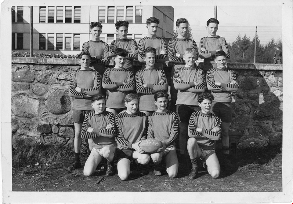
Burnaby South High School rugby team
https://search.heritageburnaby.ca/link/museumdescription15357
- Repository
- Burnaby Village Museum
- Date
- 1945 (date of original), copied 2020
- Collection/Fonds
- Burnaby Village Museum Photograph collection
- Description Level
- Item
- Physical Description
- 1 photograph (tiff) : b&w ; 1200 dpi
- Scope and Content
- Photograph of Burnaby South Highschool Junior Boys English Rugby Team. Players identified in the back row include (left to right): Alan Scott, Dave Amundsen, ?, Ernie Stevens, ?. Players identified in the middle row include: Stan Bishop (far left) and Lavergne "Vern" Hurley (center).
- Repository
- Burnaby Village Museum
- Collection/Fonds
- Burnaby Village Museum Photograph collection
- Description Level
- Item
- Physical Description
- 1 photograph (tiff) : b&w ; 1200 dpi
- Scope and Content
- Photograph of Burnaby South Highschool Junior Boys English Rugby Team. Players identified in the back row include (left to right): Alan Scott, Dave Amundsen, ?, Ernie Stevens, ?. Players identified in the middle row include: Stan Bishop (far left) and Lavergne "Vern" Hurley (center).
- Names
- Burnaby South High School
- Hurley, Lavergne "Vern"
- Amundsen, Dave
- Scott, Alan
- Stevens, Ernie
- Bishop, Stanley "Stan"
- Geographic Access
- Pandora Street
- Street Address
- 4375 Pandora Street
- Accession Code
- BV020.39.3
- Access Restriction
- No restrictions
- Reproduction Restriction
- No known restrictions
- Date
- 1945 (date of original), copied 2020
- Media Type
- Photograph
- Historic Neighbourhood
- Vancouver Heights (Historic Neighbourhood)
- Planning Study Area
- Burnaby Heights Area
- Scan Resolution
- 600
- Scan Date
- March 25, 2021
- Scale
- 100
- Notes
- Title based on contents of photograph
- Note in black ink on verso of original photograph reads: "1945-46 / From LaVergne / Juniior English Rugby 1945-46"
Images
Fire insurance plans - Greater Vancouver - Volume XV - Municipality of Burnaby
https://search.heritageburnaby.ca/link/museumdescription17795
- Repository
- Burnaby Village Museum
- Date
- 1927-1940
- Collection/Fonds
- Burnaby Village Museum Map collection
- Description Level
- Item
- Physical Description
- 11 plans on 8 sheets : col. lithographic print ; 64 x 54 cm
- Scope and Content
- Item consists of fire insurance plans titled "Greater Vancouver / Volume XV / Municipality / of Burnaby" surveyed May 1927 and revised October 1940. Volume XV includes a two page Key Plan (A and B) identifying associated plan numbers and district lots and nine numbered fire insurance plans identifi…
- Repository
- Burnaby Village Museum
- Collection/Fonds
- Burnaby Village Museum Map collection
- Description Level
- Item
- Physical Description
- 11 plans on 8 sheets : col. lithographic print ; 64 x 54 cm
- Material Details
- Scales between [1:600] and [1:6000]
- Scope and Content
- Item consists of fire insurance plans titled "Greater Vancouver / Volume XV / Municipality / of Burnaby" surveyed May 1927 and revised October 1940. Volume XV includes a two page Key Plan (A and B) identifying associated plan numbers and district lots and nine numbered fire insurance plans identified as; 1507; 1508 ; 1517; 1518; 1519; 1520;1521; 1531and 1532.
- Publisher
- Plan Department of Fire Branch of British Columbia Underwriters' Association
- Accession Code
- BV987.1.70
- Access Restriction
- No restrictions
- Reproduction Restriction
- May be restricted by third party rights
- Date
- 1927-1940
- Media Type
- Cartographic Material
- Historic Neighbourhood
- Vancouver Heights (Historic Neighbourhood)
- Planning Study Area
- Burnaby Heights Area
- Willingdon Heights Area
- Scan Resolution
- 400
- Notes
- Title based on contents of item
- These plans are contained within a bound book with labels on cover page reading: "Plan No. 90 / THIS INSURANCE PLAN / of / Vancouver VOLUME "8" / IN THE PROPERTY OF THE / British Columbia Insurance Underwriter's Association / Vancouver B.C. / AND IS LOANED / MELVILLE F. THOMSON CO. .../ Date May 26th, 1934"; / "Plan No. 74 / THIS INSURANCE PLAN / OF / VANCOUVER VOLUME "9"" / Plan No. 11 / THIS INSURANCE PLAN / OF / BURNABY VOLUMES 15-19" / "THIS PLAN IS THE PROPERTY OF / THE / BRITISH LAW INSURANCE COMPANY / LIMITED"
- Fire insurance plans cover various district lots in Burnaby including: District Lot 116,121, 186 and 187.
- Sticker adhered to Key Plan B reads: "
- Contact Burnaby Village Museum to view fire insurance plans that are part of Volume XV
![Gilmore Avenue School, 1940 (date of original) copied [between 1975 and 1985] thumbnail](/media/hpo/_Data/_Archives_Images/_Unrestricted/001/033-003.jpg?width=280)
Gilmore Avenue School
https://search.heritageburnaby.ca/link/archivedescription34515
- Repository
- City of Burnaby Archives
- Date
- 1940 (date of original) copied [between 1975 and 1985]
- Collection/Fonds
- Burnaby Historical Society fonds
- Description Level
- Item
- Physical Description
- 1 photograph : b&w ; 13.0 x 19.2 cm print
- Scope and Content
- Photograph of the exterior of Gilmore Avenue School with children standing outside.
- Repository
- City of Burnaby Archives
- Date
- 1940 (date of original) copied [between 1975 and 1985]
- Collection/Fonds
- Burnaby Historical Society fonds
- Subseries
- Jeanie Brown subseries
- Physical Description
- 1 photograph : b&w ; 13.0 x 19.2 cm print
- Description Level
- Item
- Record No.
- 033-003
- Access Restriction
- No restrictions
- Reproduction Restriction
- No known restrictions
- Accession Number
- BHS2007-04
- Scope and Content
- Photograph of the exterior of Gilmore Avenue School with children standing outside.
- Subjects
- Buildings - Schools
- Names
- Gilmore Avenue School
- Media Type
- Photograph
- Notes
- Title based on contents of photograph
- Geographic Access
- Gilmore Avenue
- Street Address
- 50 Gilmore Avenue
- Historic Neighbourhood
- Vancouver Heights (Historic Neighbourhood)
- Planning Study Area
- Burnaby Heights Area
Images
![Gilmore Avenue School, 1940 (date of original) copied [between 1975 and 1985] thumbnail](/media/hpo/_Data/_Archives_Images/_Unrestricted/001/033-003.jpg)
![North Burnaby, [1946] thumbnail](/media/hpo/_Data/_Archives_Images/_Unrestricted/001/069-001.jpg?width=280)
North Burnaby
https://search.heritageburnaby.ca/link/archivedescription34633
- Repository
- City of Burnaby Archives
- Date
- [1946]
- Collection/Fonds
- Burnaby Historical Society fonds
- Description Level
- Item
- Physical Description
- 1 photograph : b&w ; 13.2 x 24.4 cm
- Scope and Content
- Aerial photograph of North Burnaby.
- Repository
- City of Burnaby Archives
- Date
- [1946]
- Collection/Fonds
- Burnaby Historical Society fonds
- Subseries
- Photographs subseries
- Physical Description
- 1 photograph : b&w ; 13.2 x 24.4 cm
- Description Level
- Item
- Record No.
- 069-001
- Access Restriction
- No restrictions
- Reproduction Restriction
- No known restrictions
- Accession Number
- BHS2007-04
- Scope and Content
- Aerial photograph of North Burnaby.
- Media Type
- Photograph
- Notes
- Title based on contents of photograph
- Historic Neighbourhood
- Vancouver Heights (Historic Neighbourhood)
- Capitol Hill (Historic Neighbourhood)
- Broadview (Historic Neighbourhood)
- Planning Study Area
- Burnaby Heights Area
- Willingdon Heights Area
- West Central Valley Area
- Capitol Hill Area
Images
![North Burnaby, [1946] thumbnail](/media/hpo/_Data/_Archives_Images/_Unrestricted/001/069-001.jpg)
![Sawmill, [194-] thumbnail](/media/hpo/_Data/_BVM_Images/1971/197100120075.jpg?width=280)
Sawmill
https://search.heritageburnaby.ca/link/museumdescription7
- Repository
- Burnaby Village Museum
- Date
- [194-]
- Collection/Fonds
- Burnaby Village Museum Photograph collection
- Description Level
- Item
- Physical Description
- 1 photograph : b&w ; 6.8 x 11.4 cm
- Scope and Content
- Photograph of an unidentified labourer standing by stacks of lumber at a sawmill. Another man is seen working behind him. Stamped on back of the photograph reads: "657X." This may be related to the construction of the Willingdon Heights subdivision.
- Repository
- Burnaby Village Museum
- Collection/Fonds
- Burnaby Village Museum Photograph collection
- Description Level
- Item
- Physical Description
- 1 photograph : b&w ; 6.8 x 11.4 cm
- Scope and Content
- Photograph of an unidentified labourer standing by stacks of lumber at a sawmill. Another man is seen working behind him. Stamped on back of the photograph reads: "657X." This may be related to the construction of the Willingdon Heights subdivision.
- Names
- Bingham, Alfred "Alf"
- Accession Code
- HV971.12.75
- Access Restriction
- No restrictions
- Reproduction Restriction
- No known restrictions
- Date
- [194-]
- Media Type
- Photograph
- Historic Neighbourhood
- Vancouver Heights (Historic Neighbourhood)
- Planning Study Area
- Willingdon Heights Area
- Related Material
- The unidentified man from this photograph reappears in photograph HV971.12.78
- Scan Resolution
- 600
- Scan Date
- 2023-03-21
- Notes
- Title based on contents of photograph
Images
![Sawmill, [194-] thumbnail](/media/hpo/_Data/_BVM_Images/1971/197100120075.jpg)
![Two bulldozers, [194-] thumbnail](/media/hpo/_Data/_BVM_Images/1971/197100120076.jpg?width=280)
Two bulldozers
https://search.heritageburnaby.ca/link/museumdescription8
- Repository
- Burnaby Village Museum
- Date
- [194-]
- Collection/Fonds
- Burnaby Village Museum Photograph collection
- Description Level
- Item
- Physical Description
- 1 photograph : b&w ; 6.8 x 11.4 cm
- Scope and Content
- Photograph of two bulldozers, belonging to "Holmes & Wilson Trucking", clearing a lot beside a row of houses. Building materials (bricks and lumber) are piled nearby. This may be related to the construction of the Willingdon Heights subdivision. Stamp on back of photograph reads: "342x."
- Repository
- Burnaby Village Museum
- Collection/Fonds
- Burnaby Village Museum Photograph collection
- Description Level
- Item
- Physical Description
- 1 photograph : b&w ; 6.8 x 11.4 cm
- Scope and Content
- Photograph of two bulldozers, belonging to "Holmes & Wilson Trucking", clearing a lot beside a row of houses. Building materials (bricks and lumber) are piled nearby. This may be related to the construction of the Willingdon Heights subdivision. Stamp on back of photograph reads: "342x."
- Subjects
- Industries - Construction
- Buildings - Residential - Houses
- Construction Tools and Equipment
- Names
- Bingham, Alfred "Alf"
- Accession Code
- HV971.12.76
- Access Restriction
- No restrictions
- Reproduction Restriction
- No known restrictions
- Date
- [194-]
- Media Type
- Photograph
- Historic Neighbourhood
- Vancouver Heights (Historic Neighbourhood)
- Planning Study Area
- Willingdon Heights Area
- Scan Resolution
- 600
- Scan Date
- 2023-03-21
- Notes
- Title based on contents of photograph
Images
![Two bulldozers, [194-] thumbnail](/media/hpo/_Data/_BVM_Images/1971/197100120076.jpg)
![Man on a bulldozer, [194-] thumbnail](/media/hpo/_Data/_BVM_Images/1971/197100120077.jpg?width=280)
Man on a bulldozer
https://search.heritageburnaby.ca/link/museumdescription9
- Repository
- Burnaby Village Museum
- Date
- [194-]
- Collection/Fonds
- Burnaby Village Museum Photograph collection
- Description Level
- Item
- Physical Description
- 1 photograph : b&w ; 6.9 x 11.4 cm
- Scope and Content
- Photograph of an unidentified man, possibly the operator, is standing on a bulldozer belonging to "Holmes & Wilson Trucking". Lumber stacks are nearby, and the bulldozer is on a clearing for a house lot. This may be related to the construction of the Willingdon Heights subdivision. Stamped on bac…
- Repository
- Burnaby Village Museum
- Collection/Fonds
- Burnaby Village Museum Photograph collection
- Description Level
- Item
- Physical Description
- 1 photograph : b&w ; 6.9 x 11.4 cm
- Scope and Content
- Photograph of an unidentified man, possibly the operator, is standing on a bulldozer belonging to "Holmes & Wilson Trucking". Lumber stacks are nearby, and the bulldozer is on a clearing for a house lot. This may be related to the construction of the Willingdon Heights subdivision. Stamped on back of photo: "342X."
- Names
- Bingham, Alfred "Alf"
- Accession Code
- HV971.12.77
- Access Restriction
- No restrictions
- Reproduction Restriction
- No known restrictions
- Date
- [194-]
- Media Type
- Photograph
- Historic Neighbourhood
- Vancouver Heights (Historic Neighbourhood)
- Planning Study Area
- Willingdon Heights Area
- Scan Resolution
- 600
- Scan Date
- 2023-03-21
- Notes
- Title based on contents of photograph
Images
![Man on a bulldozer, [194-] thumbnail](/media/hpo/_Data/_BVM_Images/1971/197100120077.jpg)
![Man on a bulldozer, [194-] thumbnail](/media/hpo/_Data/_BVM_Images/1971/197100120078.jpg?width=280)
Man on a bulldozer
https://search.heritageburnaby.ca/link/museumdescription10
- Repository
- Burnaby Village Museum
- Date
- [194-]
- Collection/Fonds
- Burnaby Village Museum Photograph collection
- Description Level
- Item
- Physical Description
- 1 photograph : b&w ; 6.9 x 11.9 cm
- Scope and Content
- Photograph of an unidentified man standing on a bulldozer belonging to "Wm. Edstrom" as written on the machine. The bulldozer is on a clearing nearby houses. This may be related to the construction of the Willingdon Heights subdivision. Stamped on back of the photograph: "342X."
- Repository
- Burnaby Village Museum
- Collection/Fonds
- Burnaby Village Museum Photograph collection
- Description Level
- Item
- Physical Description
- 1 photograph : b&w ; 6.9 x 11.9 cm
- Scope and Content
- Photograph of an unidentified man standing on a bulldozer belonging to "Wm. Edstrom" as written on the machine. The bulldozer is on a clearing nearby houses. This may be related to the construction of the Willingdon Heights subdivision. Stamped on back of the photograph: "342X."
- Names
- Bingham, Alfred "Alf"
- Accession Code
- HV971.12.78
- Access Restriction
- No restrictions
- Reproduction Restriction
- No known restrictions
- Date
- [194-]
- Media Type
- Photograph
- Historic Neighbourhood
- Vancouver Heights (Historic Neighbourhood)
- Planning Study Area
- Willingdon Heights Area
- Scan Resolution
- 600
- Scan Date
- 2023-03-21
- Notes
- Title based on contents of photograph
Images
![Man on a bulldozer, [194-] thumbnail](/media/hpo/_Data/_BVM_Images/1971/197100120078.jpg)
![Bulldozer clearing a Forested Hill, [194-] thumbnail](/media/hpo/_Data/_BVM_Images/1971/197100120079.jpg?width=280)
Bulldozer clearing a Forested Hill
https://search.heritageburnaby.ca/link/museumdescription11
- Repository
- Burnaby Village Museum
- Date
- [194-]
- Collection/Fonds
- Burnaby Village Museum Photograph collection
- Description Level
- Item
- Physical Description
- 1 photograph : b&w ; 6.8 x 11.5 cm
- Scope and Content
- Photograph of a man operating a bulldozer clearing a forested hill. There appears to be a backhoe on the other side of the hill of fallen and upturned trees. This may be the site of the Willingdon Heights subdivision. Stamped on back of photograph: "342X."
- Repository
- Burnaby Village Museum
- Collection/Fonds
- Burnaby Village Museum Photograph collection
- Description Level
- Item
- Physical Description
- 1 photograph : b&w ; 6.8 x 11.5 cm
- Scope and Content
- Photograph of a man operating a bulldozer clearing a forested hill. There appears to be a backhoe on the other side of the hill of fallen and upturned trees. This may be the site of the Willingdon Heights subdivision. Stamped on back of photograph: "342X."
- Names
- Bingham, Alfred "Alf"
- Accession Code
- HV971.12.79
- Access Restriction
- No restrictions
- Reproduction Restriction
- No known restrictions
- Date
- [194-]
- Media Type
- Photograph
- Historic Neighbourhood
- Vancouver Heights (Historic Neighbourhood)
- Planning Study Area
- Willingdon Heights Area
- Scan Resolution
- 600
- Scan Date
- 2023-03-21
- Notes
- Title based on contents of photograph
Images
![Bulldozer clearing a Forested Hill, [194-] thumbnail](/media/hpo/_Data/_BVM_Images/1971/197100120079.jpg)
![Man on a bulldozer, [194-] thumbnail](/media/hpo/_Data/_BVM_Images/1971/197100120080.jpg?width=280)
Man on a bulldozer
https://search.heritageburnaby.ca/link/museumdescription12
- Repository
- Burnaby Village Museum
- Date
- [194-]
- Collection/Fonds
- Burnaby Village Museum Photograph collection
- Description Level
- Item
- Physical Description
- 1 photograph : b&w ; 6.8 x 11.3 cm
- Scope and Content
- Photograph of an unidentified man standing on a bulldozer. The bulldozer is on a cleared lot, behind which houses and electric posts along a road can be seen. This may be the site of the Willingdon Heights subdivision. Stamped on the back of the photograph: "345L."
- Repository
- Burnaby Village Museum
- Collection/Fonds
- Burnaby Village Museum Photograph collection
- Description Level
- Item
- Physical Description
- 1 photograph : b&w ; 6.8 x 11.3 cm
- Scope and Content
- Photograph of an unidentified man standing on a bulldozer. The bulldozer is on a cleared lot, behind which houses and electric posts along a road can be seen. This may be the site of the Willingdon Heights subdivision. Stamped on the back of the photograph: "345L."
- Names
- Bingham, Alfred "Alf"
- Accession Code
- HV971.12.80
- Access Restriction
- No restrictions
- Reproduction Restriction
- No known restrictions
- Date
- [194-]
- Media Type
- Photograph
- Historic Neighbourhood
- Vancouver Heights (Historic Neighbourhood)
- Planning Study Area
- Willingdon Heights Area
- Related Material
- the unidentified man in the photograph reappears in photograph HV971.12.81
- Scan Resolution
- 600
- Scan Date
- 2023-03-21
- Notes
- Title based on contents of photograph
Images
![Man on a bulldozer, [194-] thumbnail](/media/hpo/_Data/_BVM_Images/1971/197100120080.jpg)