Narrow Results By
Subject
- Accidents 2
- Advertising Medium - Signs and Signboards 11
- Aerial Photographs 7
- Agricultural Tools and Equipment - Cultivators 1
- Agricultural Tools and Equipment - Gardening Equipment 1
- Agriculture - Farms 3
- Agriculture - Poultry 1
- Animals - Dogs 1
- Animals - Horses 3
- Buildings - Agricultural - Barns 3
- Buildings - Commercial 3
- Buildings - Commercial - General Stores 1

Lochdale Neighbourhood
https://search.heritageburnaby.ca/link/landmark668
- Repository
- Burnaby Heritage Planning
- Associated Dates
- 1925-1954
- Heritage Value
- In the 1931 "Burnaby Year Book" the Lochdale neighbourhood is described as follows: "Lochdale…is situated at the intersection of the Hastings-Barnet road at the point where Sperling Avenue crosses…Situated at the intersection…there are an up to date service station and a general store, at which the Lochdale Post Office is situated. Immediately north of this is the seventy acres on which the Shell Oil Co. are to build an up-to-date refinery...On going south on Sperling Avenue can be found some lovely homes of the residents, all of which possess the most beautiful flower gardens, some of which are hobbies, and some being in the nature of a business. Others are engaged in chicken farming...while others find employment at the Barnet Mill about two miles east on the Hastings-Barnet Road."
- Historic Neighbourhood
- Lochdale (Historic Neighbourhood)
- Planning Study Area
- Lochdale Area
Images


Shell Oil Company
https://search.heritageburnaby.ca/link/landmark675
- Repository
- Burnaby Heritage Planning
- Geographic Access
- Kensington Avenue
- Associated Dates
- ca. 1930-1993
- Heritage Value
- After considering several sites in the Greater Vancouver area, the Shell Oil Company chose 70 acres in North Burnaby with frontage of one third of a mile on Burrard Inlet. Shell proposed to build a four-million dollar plant that would employ up to 2000 - providing some relief in the middle of Burnaby's economic crisis of the Depression years. The site became known as the Shellburn Refinery and was in operation until 1993.
- Historic Neighbourhood
- Lochdale (Historic Neighbourhood)
- Planning Study Area
- Westridge Area
Images


Westridge Neighbourhood
https://search.heritageburnaby.ca/link/landmark680
- Repository
- Burnaby Heritage Planning
- Associated Dates
- 1925-1954
- Heritage Value
- The Westridge Neighbourhood of Burnaby was created as a new subdivision during the post-World War Two housing boom in Burnaby. Developed by the C.B. Riley Company, it was laid out in a plan contoured to the shapes of the land and was situated to allow residents easy access to main transportation routes.
- Historic Neighbourhood
- Lochdale (Historic Neighbourhood)
- Planning Study Area
- Westridge Area
Images


Lochdale Neighbourhood
https://search.heritageburnaby.ca/link/landmark743
- Repository
- Burnaby Heritage Planning
- Associated Dates
- 1905-1924
- Heritage Value
- "Picturesquely situated on the south-westerly slope of the highest hill on the Burrard Peninsula is a district that in many ways resembles the early pioneer settlements…its centre is at the intersection of east Hastings Street and Sperling Avenue. Only a few years ago a dense forest covered this area and the settlers were few and some distance apart. After the war working men began to enter the Lochdale woods in quest of cheap home-sites. Today there are more than 400 residents in the district who combine to make a happy contented industrious community living on the edge of a big city yet enjoying the life offered by the country...The Community Hall is the centre of all social activities. Dances, concerts and other forms of entertainment are all there...Curtis Street runs from Sperling Avenue up to the hill, locally known as Hastings Grove. From the top on a clear day there is a view for miles around." ~ From the Sunday Province, March 8, 1925.
- Historic Neighbourhood
- Lochdale (Historic Neighbourhood)
- Planning Study Area
- Lochdale Area
Images


Hastings Grove Neighbourhood
https://search.heritageburnaby.ca/link/landmark746
- Repository
- Burnaby Heritage Planning
- Associated Dates
- 1905-1924
- Heritage Value
- During the height of the real estate boom between 1909 and 1913, Vancouver developer Frederick Munson plotted the subdivision of more than 150 acres of land on Curtis Street east of Sperling Avenue, on the newly logged slopes of remote Burnaby Mountain. Burnaby opened up Curtis Street to facilitate access to Hastings Grove and Munson agreed to pay one-third of the cost but never did. He also paid only $1000.00 down on the agreed price of the land. When he failed to make further payments, the mortgage holders foreclosed and re-sold the properties. People who had bought lots from Munson lost not only the land they though they owned, but also the money they had paid for it. Hastings Grove was a disaster. The converted automobile - which served as the bus - stopped running. The few houses and most of the lots reverted to the Municipality because of non-payment of taxes and are now part of Burnaby Mountain Park. The only remaining building is the old Hastings Grove Store which still stands as an apartment building.
- Historic Neighbourhood
- Lochdale (Historic Neighbourhood)
- Planning Study Area
- Lochdale Area
Images


Sperling-Broadway Neighbourhood
https://search.heritageburnaby.ca/link/landmark789
- Repository
- Burnaby Heritage Planning
- Associated Dates
- 1955-2008
- Heritage Value
- By the 1970s, the Sperling-Broadway Neighbourhood was characterised as one of the Municipality's fastest growing residential areas. In 1980, it was estimated that slightly less than half of the homes were single-family residences, while the remaining development was taking the form of townhouse and high-rise apartments. The emphasis shifted back to single family housing during the construction of planned subdivisions such as the Camrose subdivision in the 1980s and the area remains primarily residential in nature. The neighbourhood is well-served by park facilities and is also home to the Burnaby Mountain Golf Course.
- Historic Neighbourhood
- Lochdale (Historic Neighbourhood)
- Planning Study Area
- Sperling-Broadway Area
Images


Lochdale Neighbourhood
https://search.heritageburnaby.ca/link/landmark790
- Repository
- Burnaby Heritage Planning
- Associated Dates
- 1955-2008
- Heritage Value
- Despite the rapid growth witnessed in Burnaby in the post-war years, the Lochdale Neighbourhood was characterised as a close-knit primarily residential community. Although a commercial zone developed along Sperling and Hastings, single-family, duplex and multi-family homes were the primary buildings in the area. Basement suites and student accommodation also flourished in this neighbourhood after the creation of Simon Fraser University on Burnaby Mountain.
- Historic Neighbourhood
- Lochdale (Historic Neighbourhood)
- Planning Study Area
- Lochdale Area
Images


Westridge Neighbourhood
https://search.heritageburnaby.ca/link/landmark791
- Repository
- Burnaby Heritage Planning
- Associated Dates
- 1955-2008
- Heritage Value
- The Westridge Neighbourhood is effectively separated into two areas by Inlet Drive. To the west of the highway lies a typical 1950s subdivision of single-family homes, while to the east is a newer (1970s) subdivision featuring larger lots and some low-rise units. In the 1980 Residential Neighbourhood Environment Study, Westridge was characterised as a stable community with little need for direct Municipal involvement in growth and development.
- Historic Neighbourhood
- Lochdale (Historic Neighbourhood)
- Planning Study Area
- Westridge Area
Images

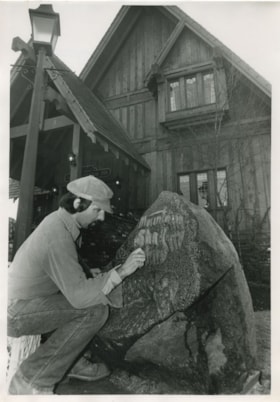
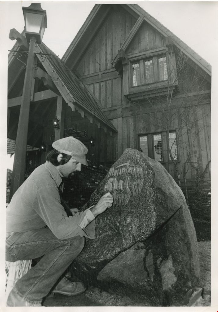
A man outside the Mountain Shadow Pub
https://search.heritageburnaby.ca/link/archivedescription58922
- Repository
- City of Burnaby Archives
- Date
- ca.1980
- Collection/Fonds
- Columbian Newspaper collection
- Description Level
- Item
- Physical Description
- 1 photograph : b&w ; 20.5 x 18 cm
- Scope and Content
- Photograph of a man outside the Mountain Shadow Pub that was located at the base of Burnaby Mountain. He appears to be rewriting the name of the pub on a rock.
- Repository
- City of Burnaby Archives
- Date
- ca.1980
- Collection/Fonds
- Columbian Newspaper collection
- Physical Description
- 1 photograph : b&w ; 20.5 x 18 cm
- Description Level
- Item
- Record No.
- 480-1373
- Access Restriction
- No restrictions
- Reproduction Restriction
- Reproduce for fair dealing purposes only
- Accession Number
- 2009-01
- Scope and Content
- Photograph of a man outside the Mountain Shadow Pub that was located at the base of Burnaby Mountain. He appears to be rewriting the name of the pub on a rock.
- Subjects
- Buildings - Commercial
- Media Type
- Photograph
- Photographer
- Hodge, Craig
- Notes
- Title based on contents of photograph
- Photographer's stamp on verso
- Note on verso reads: "page A-3 / Burnaby Today / PMT 110%"
- Geographic Access
- Burnaby Mountain Conservation Area
- Historic Neighbourhood
- Lochdale (Historic Neighbourhood)
- Planning Study Area
- Burnaby Mountain Area
Images
![Logging Camp, [1903] thumbnail](/media/hpo/_Data/_BVM_Images/1977/1977_0140_0004_001.jpg?width=280)
Logging Camp
https://search.heritageburnaby.ca/link/museumdescription639
- Repository
- Burnaby Village Museum
- Date
- [1903]
- Collection/Fonds
- Burnaby Village Museum Photograph collection
- Description Level
- Item
- Physical Description
- 1 photograph : b&w ; 11.5 x 17.5 cm mounted on card 18.5 x 23 cm
- Scope and Content
- Photograph of a crew of loggers sitting and standing in front of their cabins at a logging camp at Broadway, west of Sperling Avenue. Robert Pontifex is standing fourth from the right.
- Repository
- Burnaby Village Museum
- Collection/Fonds
- Burnaby Village Museum Photograph collection
- Description Level
- Item
- Physical Description
- 1 photograph : b&w ; 11.5 x 17.5 cm mounted on card 18.5 x 23 cm
- Scope and Content
- Photograph of a crew of loggers sitting and standing in front of their cabins at a logging camp at Broadway, west of Sperling Avenue. Robert Pontifex is standing fourth from the right.
- Subjects
- Occupations - Lumberjacks
- Names
- Pontifex, Robert
- Geographic Access
- Broadway
- Sperling Avenue
- Accession Code
- HV977.140.4
- Access Restriction
- No restrictions
- Date
- [1903]
- Media Type
- Photograph
- Historic Neighbourhood
- Lochdale (Historic Neighbourhood)
- Planning Study Area
- Sperling-Broadway Area
- Scan Resolution
- 600
- Scan Date
- 2023-07-25
- Notes
- Title based on contents of photograph
- Handwritten notes on verso of card mount read: "Broadway West of Sperling Ave / 1903" and "Mr. Doug Lorky."
Images
![Logging Camp, [1903] thumbnail](/media/hpo/_Data/_BVM_Images/1977/1977_0140_0004_001.jpg)


Barnet Wagon Road
https://search.heritageburnaby.ca/link/archivedescription38306
- Repository
- City of Burnaby Archives
- Date
- June 1903 (date of original), copied ca. 1990
- Collection/Fonds
- Burnaby Historical Society fonds
- Description Level
- Item
- Physical Description
- 1 photograph : b&w ; 10 x 15 cm print
- Scope and Content
- Photograph of the Barnet Wagon Road looking west from Sperling Avenue.
- Repository
- City of Burnaby Archives
- Date
- June 1903 (date of original), copied ca. 1990
- Collection/Fonds
- Burnaby Historical Society fonds
- Subseries
- Photographs subseries
- Physical Description
- 1 photograph : b&w ; 10 x 15 cm print
- Description Level
- Item
- Record No.
- 403-001
- Access Restriction
- No restrictions
- Reproduction Restriction
- No known restrictions
- Accession Number
- BHS2007-04
- Scope and Content
- Photograph of the Barnet Wagon Road looking west from Sperling Avenue.
- Subjects
- Land Clearing
- Geographic Features - Roads
- Media Type
- Photograph
- Notes
- Title based on contents of photograph
- Geographic Access
- Barnet Road
- Sperling Avenue
- Historic Neighbourhood
- Lochdale (Historic Neighbourhood)
- Planning Study Area
- Westridge Area
Images


Barnet Wagon Road
https://search.heritageburnaby.ca/link/archivedescription38307
- Repository
- City of Burnaby Archives
- Date
- June 1903 (date of original), copied ca. 1990
- Collection/Fonds
- Burnaby Historical Society fonds
- Description Level
- Item
- Physical Description
- 1 photograph : b&w ; 10 x 15 cm print
- Scope and Content
- Photograph of the Barnet Wagon Road looking east, near Barnet and Hastings.
- Repository
- City of Burnaby Archives
- Date
- June 1903 (date of original), copied ca. 1990
- Collection/Fonds
- Burnaby Historical Society fonds
- Subseries
- Photographs subseries
- Physical Description
- 1 photograph : b&w ; 10 x 15 cm print
- Description Level
- Item
- Record No.
- 403-002
- Access Restriction
- No restrictions
- Reproduction Restriction
- No known restrictions
- Accession Number
- BHS2007-04
- Scope and Content
- Photograph of the Barnet Wagon Road looking east, near Barnet and Hastings.
- Subjects
- Land Clearing
- Geographic Features - Roads
- Media Type
- Photograph
- Notes
- Title based on contents of photograph
- Geographic Access
- Barnet Road
- Hastings Street
- Historic Neighbourhood
- Lochdale (Historic Neighbourhood)
- Planning Study Area
- Westridge Area
Images

![Pengelly's logging shack, [1909] thumbnail](/media/hpo/_Data/_Archives_Images/_Unrestricted/205/222-005.jpg?width=280)
Pengelly's logging shack
https://search.heritageburnaby.ca/link/archivedescription36082
- Repository
- City of Burnaby Archives
- Date
- [1909]
- Collection/Fonds
- Burnaby Historical Society fonds
- Description Level
- Item
- Physical Description
- 1 photograph : b&w ; 9 x 11.5 cm
- Scope and Content
- Photograph of Pengelly's logging shack, believed to be at Union Street and Duthie Avenue. One lumberjack is standing just outside the shack with an axe in his hand, while another is wiping his face with a cloth and a third is standing with one foot bracing a felled log with a saw in his hand.
- Repository
- City of Burnaby Archives
- Date
- [1909]
- Collection/Fonds
- Burnaby Historical Society fonds
- Subseries
- Columbian Newspaper subseries
- Physical Description
- 1 photograph : b&w ; 9 x 11.5 cm
- Description Level
- Item
- Record No.
- 222-005
- Access Restriction
- No restrictions
- Reproduction Restriction
- No known restrictions
- Accession Number
- BHS1989-19
- Scope and Content
- Photograph of Pengelly's logging shack, believed to be at Union Street and Duthie Avenue. One lumberjack is standing just outside the shack with an axe in his hand, while another is wiping his face with a cloth and a third is standing with one foot bracing a felled log with a saw in his hand.
- Media Type
- Photograph
- Notes
- Title based on contents of photograph
- 2 b&w copy negatives accompanying
- Geographic Access
- Duthie Avenue
- Union Street
- Historic Neighbourhood
- Lochdale (Historic Neighbourhood)
- Planning Study Area
- Lochdale Area
Images
![Pengelly's logging shack, [1909] thumbnail](/media/hpo/_Data/_Archives_Images/_Unrestricted/205/222-005.jpg)
![Johnston Road School, [between 1911 and 1919] thumbnail](/media/hpo/_Data/_Archives_Images/_Unrestricted/316/325-030.jpg?width=280)
Johnston Road School
https://search.heritageburnaby.ca/link/archivedescription37158
- Repository
- City of Burnaby Archives
- Date
- [between 1911 and 1919]
- Collection/Fonds
- Burnaby Historical Society fonds
- Description Level
- Item
- Physical Description
- 1 photograph : b&w ; 7.5 x 12.5 cm print
- Scope and Content
- Photograph of Johnston Road School (also called Duthie School) taken from Broadway. This school existed from 1909 to 1921.
- Repository
- City of Burnaby Archives
- Date
- [between 1911 and 1919]
- Collection/Fonds
- Burnaby Historical Society fonds
- Subseries
- Disney family subseries
- Physical Description
- 1 photograph : b&w ; 7.5 x 12.5 cm print
- Description Level
- Item
- Record No.
- 325-030
- Access Restriction
- No restrictions
- Reproduction Restriction
- No known restrictions
- Accession Number
- BHS1996-04
- Scope and Content
- Photograph of Johnston Road School (also called Duthie School) taken from Broadway. This school existed from 1909 to 1921.
- Subjects
- Buildings - Schools
- Media Type
- Photograph
- Photographer
- Disney, John Harold "Jack"
- Notes
- Title based on contents of photograph
- Geographic Access
- Broadway
- Sperling Avenue
- Historic Neighbourhood
- Lochdale (Historic Neighbourhood)
- Planning Study Area
- Sperling-Broadway Area
Images
![Johnston Road School, [between 1911 and 1919] thumbnail](/media/hpo/_Data/_Archives_Images/_Unrestricted/316/325-030.jpg)
![In front of Duthie School, [between 1911 and 1919] thumbnail](/media/hpo/_Data/_Archives_Images/_Unrestricted/316/325-031.jpg?width=280)
In front of Duthie School
https://search.heritageburnaby.ca/link/archivedescription37159
- Repository
- City of Burnaby Archives
- Date
- [between 1911 and 1919]
- Collection/Fonds
- Burnaby Historical Society fonds
- Description Level
- Item
- Physical Description
- 1 photograph : b&w ; 12.5 x 8 cm print
- Scope and Content
- Photograph of a man with surveyor equipment sitting on the wooden sidewalk in front of Duthie School (also called Johnston Road School). This school existed from 1909 to 1921.
- Repository
- City of Burnaby Archives
- Date
- [between 1911 and 1919]
- Collection/Fonds
- Burnaby Historical Society fonds
- Subseries
- Disney family subseries
- Physical Description
- 1 photograph : b&w ; 12.5 x 8 cm print
- Description Level
- Item
- Record No.
- 325-031
- Access Restriction
- No restrictions
- Reproduction Restriction
- No known restrictions
- Accession Number
- BHS1996-04
- Scope and Content
- Photograph of a man with surveyor equipment sitting on the wooden sidewalk in front of Duthie School (also called Johnston Road School). This school existed from 1909 to 1921.
- Subjects
- Buildings - Schools
- Names
- Duthie School
- Media Type
- Photograph
- Photographer
- Disney, John Harold "Jack"
- Notes
- Title based on contents of photograph
- Geographic Access
- Broadway
- Sperling Avenue
- Historic Neighbourhood
- Lochdale (Historic Neighbourhood)
- Planning Study Area
- Sperling-Broadway Area
Images
![In front of Duthie School, [between 1911 and 1919] thumbnail](/media/hpo/_Data/_Archives_Images/_Unrestricted/316/325-031.jpg)
On Curtis Road, North Burnaby
https://search.heritageburnaby.ca/link/archivedescription38854
- Repository
- City of Burnaby Archives
- Date
- 1911
- Collection/Fonds
- Peers Family and Hill Family fonds
- Description Level
- Item
- Physical Description
- 1 photograph : b&w ; 6 x 10 cm on page 14 x 17.5 cm (pasted in album)
- Scope and Content
- Photograph of Claude Hill (right) and E.B. Wentenhall (left) standing on a bridge on Curtis Road in North Burnaby. Both men are holding walking sticks.
- Repository
- City of Burnaby Archives
- Date
- 1911
- Collection/Fonds
- Peers Family and Hill Family fonds
- Physical Description
- 1 photograph : b&w ; 6 x 10 cm on page 14 x 17.5 cm (pasted in album)
- Description Level
- Item
- Record No.
- 477-173
- Access Restriction
- No restrictions
- Reproduction Restriction
- No known restrictions
- Accession Number
- 2007-12
- Scope and Content
- Photograph of Claude Hill (right) and E.B. Wentenhall (left) standing on a bridge on Curtis Road in North Burnaby. Both men are holding walking sticks.
- Subjects
- Structures - Bridges
- Media Type
- Photograph
- Notes
- Title based on caption accompanying photograph
- Geographic Access
- Curtis Street
- Historic Neighbourhood
- Lochdale (Historic Neighbourhood)
- Planning Study Area
- Lochdale Area
Images

Tired Tim and Weary Willie
https://search.heritageburnaby.ca/link/archivedescription38855
- Repository
- City of Burnaby Archives
- Date
- 1911
- Collection/Fonds
- Peers Family and Hill Family fonds
- Description Level
- Item
- Physical Description
- 1 photograph : sepia ; 6 x 10 cm on page 14 x 17.5 cm (pasted in album)
- Scope and Content
- Photograph of Claude Hill (left) and E.B. Wentenhall (right) standing on fallen trees in the Curtis Road area of North Burnaby.
- Repository
- City of Burnaby Archives
- Date
- 1911
- Collection/Fonds
- Peers Family and Hill Family fonds
- Physical Description
- 1 photograph : sepia ; 6 x 10 cm on page 14 x 17.5 cm (pasted in album)
- Description Level
- Item
- Record No.
- 477-174
- Access Restriction
- No restrictions
- Reproduction Restriction
- No known restrictions
- Accession Number
- 2007-12
- Scope and Content
- Photograph of Claude Hill (left) and E.B. Wentenhall (right) standing on fallen trees in the Curtis Road area of North Burnaby.
- Subjects
- Land Clearing
- Plants - Trees
- Media Type
- Photograph
- Notes
- Title based on caption accompanying photograph
- Geographic Access
- Curtis Street
- Historic Neighbourhood
- Lochdale (Historic Neighbourhood)
- Planning Study Area
- Lochdale Area
Images

Gavin house
https://search.heritageburnaby.ca/link/archivedescription36002
- Repository
- City of Burnaby Archives
- Date
- 1912
- Collection/Fonds
- Burnaby Historical Society fonds
- Description Level
- Item
- Physical Description
- 1 photograph : b&w ; 8.5 x 12.5 cm print
- Scope and Content
- Photograph of the Gavin house located on Buckingham Road at Sperling. The house was designed by architect A.C. Hope and built for Francis John Gavin and his family.
- Repository
- City of Burnaby Archives
- Date
- 1912
- Collection/Fonds
- Burnaby Historical Society fonds
- Subseries
- Gavin family subseries
- Physical Description
- 1 photograph : b&w ; 8.5 x 12.5 cm print
- Description Level
- Item
- Record No.
- 209-001
- Access Restriction
- No restrictions
- Reproduction Restriction
- No known restrictions
- Accession Number
- BHS1988-09
- Scope and Content
- Photograph of the Gavin house located on Buckingham Road at Sperling. The house was designed by architect A.C. Hope and built for Francis John Gavin and his family.
- Subjects
- Buildings - Residential - Houses
- Media Type
- Photograph
- Notes
- Title based on contents of photograph
- Geographic Access
- Buckingham Avenue
- Sperling Avenue
- Historic Neighbourhood
- Lochdale (Historic Neighbourhood)
- Planning Study Area
- Sperling-Broadway Area
Images


Sperling Avenue School during construction
https://search.heritageburnaby.ca/link/archivedescription36027
- Repository
- City of Burnaby Archives
- Date
- 1913
- Collection/Fonds
- Burnaby Historical Society fonds
- Description Level
- Item
- Physical Description
- 1 photograph : sepia
- Scope and Content
- Photograph of the Sperling Avenue School during construction. This was the first school ever built by Bruce Patterson.
- Repository
- City of Burnaby Archives
- Date
- 1913
- Collection/Fonds
- Burnaby Historical Society fonds
- Subseries
- Patterson family subseries
- Physical Description
- 1 photograph : sepia
- Description Level
- Item
- Record No.
- 213-009
- Access Restriction
- No restrictions
- Reproduction Restriction
- No known restrictions
- Accession Number
- BHS1988-13
- Scope and Content
- Photograph of the Sperling Avenue School during construction. This was the first school ever built by Bruce Patterson.
- Media Type
- Photograph
- Notes
- Title based on contents of photograph
- Hand written note on verso of photograph reads: "1st School Bruce built"
- Geographic Access
- Sperling Avenue
- Street Address
- 2200 Sperling Avenue
- Historic Neighbourhood
- Lochdale (Historic Neighbourhood)
- Planning Study Area
- Sperling-Broadway Area
Images

Sperling Avenue School
https://search.heritageburnaby.ca/link/landmark744
- Repository
- Burnaby Heritage Planning
- Geographic Access
- Sperling Avenue
- Associated Dates
- 1914
- Heritage Value
- The Sperling Avenue School was opened in 1914 to service the growing community around the B.C. Electric Company's Pole Line Road (Sperling Avenue). This school replaced the one-room Duthie schoolhouse.
- Historic Neighbourhood
- Lochdale (Historic Neighbourhood)
- Planning Study Area
- Sperling-Broadway Area
- Street Address
- 2200 Sperling Avenue
- Street View URL
- Google Maps Street View
Images