Narrow Results By
Subject
- Accidents 2
- Advertising Medium - Signs and Signboards 2
- Aerial Photographs 2
- Agricultural Tools and Equipment - Cultivators 1
- Agricultural Tools and Equipment - Gardening Equipment 1
- Agriculture - Farms 1
- Animals - Horses 2
- Buildings - Agricultural - Barns 1
- Buildings - Commercial - Hotels and Motels 1
- Buildings - Commercial - Restaurants 2
- Buildings - Commercial - Stores 2
- Buildings - Industrial - Mills 1

Lochdale Community Hall
https://search.heritageburnaby.ca/link/landmark549
- Repository
- Burnaby Heritage Planning
- Description
- The Lochdale Community Hall is a one-storey wood-frame building located on Sperling Avenue, near its intersection with Hastings Street, in the centre of the Lochdale district in North Burnaby. Built in stages, its current configuration has an L-shaped plan, with three different roof structures.
- Associated Dates
- 1925
- Formal Recognition
- Heritage Designation, Community Heritage Register
- Street View URL
- Google Maps Street View
- Repository
- Burnaby Heritage Planning
- Geographic Access
- Sperling Avenue
- Associated Dates
- 1925
- Formal Recognition
- Heritage Designation, Community Heritage Register
- Enactment Type
- Bylaw No. 9807
- Enactment Date
- 23/11/1992
- Description
- The Lochdale Community Hall is a one-storey wood-frame building located on Sperling Avenue, near its intersection with Hastings Street, in the centre of the Lochdale district in North Burnaby. Built in stages, its current configuration has an L-shaped plan, with three different roof structures.
- Heritage Value
- The heritage value of the Lochdale Community Hall is as Burnaby’s last remaining early community hall building. It was constructed with volunteer labour and donated materials in 1925 through the efforts of the Lochdale Social Club. The Hall is a valuable reminder of the way in which early communities banded together for mutual support at a time when transportation was more difficult and local communities were more isolated than today. This residents’ association has used this building to support the community through public political meetings, theatre, dinners and dances, creating strong community ties in North Burnaby. The Hall was also used briefly for the services of St. Margaret of Scotland Anglican parish until their church was completed in 1929, demonstrating a spirit of community cooperation at a time when local institutions were being established in the area.
- Defining Elements
- Key elements that define the heritage character of the Lochdale Community Hall include its: - central location in the Lochdale community - modest vernacular architecture and massing - stepped-pitch gable roof of the main hall - shallow-pitched gable roof of the entrance porch - Craftsman style eave brackets - central front entry - interior features such as the main open hall with an elevated stage
- Locality
- Lochdale
- Historic Neighbourhood
- Lochdale (Historic Neighbourhood)
- Planning Study Area
- Lochdale Area
- Organization
- Lochdale Social Club
- Function
- Primary Current--Recreation Centre
- Primary Historic--Recreation Centre
- Community
- Burnaby
- Cadastral Identifier
- P.I.D. No. 012-091-901 Legal Description: Lot 11 Except: East five feet , Block 6, District Lot 206, Group 1, New Westminster District, Plan 1323
- Boundaries
- The Lochdale Community Hall is comprised of a single municipally-owned property located at 490 Sperling Avenue, Burnaby.
- Area
- 1,260.00
- Contributing Resource
- Building
- Ownership
- Public (local)
- Other Collection
- St. Margaret of Scotland Parish Fonds, Anglican Diocese of New Westminster Archives.
- Documentation
- Heritage Site Files: PC77000 20. City of Burnaby Planning and Building Department, 4949 Canada Way, Burnaby, B.C., V5G 1M2
- Street Address
- 490 Sperling Avenue
- Street View URL
- Google Maps Street View
Images


Lochdale Neighbourhood
https://search.heritageburnaby.ca/link/landmark668
- Repository
- Burnaby Heritage Planning
- Associated Dates
- 1925-1954
- Heritage Value
- In the 1931 "Burnaby Year Book" the Lochdale neighbourhood is described as follows: "Lochdale…is situated at the intersection of the Hastings-Barnet road at the point where Sperling Avenue crosses…Situated at the intersection…there are an up to date service station and a general store, at which the Lochdale Post Office is situated. Immediately north of this is the seventy acres on which the Shell Oil Co. are to build an up-to-date refinery...On going south on Sperling Avenue can be found some lovely homes of the residents, all of which possess the most beautiful flower gardens, some of which are hobbies, and some being in the nature of a business. Others are engaged in chicken farming...while others find employment at the Barnet Mill about two miles east on the Hastings-Barnet Road."
- Historic Neighbourhood
- Lochdale (Historic Neighbourhood)
- Planning Study Area
- Lochdale Area
Images


Lochdale School
https://search.heritageburnaby.ca/link/landmark677
- Repository
- Burnaby Heritage Planning
- Geographic Access
- Aubrey Street
- Associated Dates
- 1953
- Heritage Value
- Lochdale Community School was opened in 1953 to help alleviate the increased enrolment at Sperling Elementary School caused by the new subdivisions under construction in this section of Burnaby. Lochdale was typical of the schools built at the period with classrooms constructed in a line, as close as possible to ground level. As needed, new classrooms were extended in a line and there were additions to Lochdale in 1962, 1964, 1966, 1971 and 1976.
- Historic Neighbourhood
- Lochdale (Historic Neighbourhood)
- Planning Study Area
- Lochdale Area
- Street Address
- 6990 Aubrey Street
- Street View URL
- Google Maps Street View
Images


Lochdale Neighbourhood
https://search.heritageburnaby.ca/link/landmark743
- Repository
- Burnaby Heritage Planning
- Associated Dates
- 1905-1924
- Heritage Value
- "Picturesquely situated on the south-westerly slope of the highest hill on the Burrard Peninsula is a district that in many ways resembles the early pioneer settlements…its centre is at the intersection of east Hastings Street and Sperling Avenue. Only a few years ago a dense forest covered this area and the settlers were few and some distance apart. After the war working men began to enter the Lochdale woods in quest of cheap home-sites. Today there are more than 400 residents in the district who combine to make a happy contented industrious community living on the edge of a big city yet enjoying the life offered by the country...The Community Hall is the centre of all social activities. Dances, concerts and other forms of entertainment are all there...Curtis Street runs from Sperling Avenue up to the hill, locally known as Hastings Grove. From the top on a clear day there is a view for miles around." ~ From the Sunday Province, March 8, 1925.
- Historic Neighbourhood
- Lochdale (Historic Neighbourhood)
- Planning Study Area
- Lochdale Area
Images


Hastings Grove Neighbourhood
https://search.heritageburnaby.ca/link/landmark746
- Repository
- Burnaby Heritage Planning
- Associated Dates
- 1905-1924
- Heritage Value
- During the height of the real estate boom between 1909 and 1913, Vancouver developer Frederick Munson plotted the subdivision of more than 150 acres of land on Curtis Street east of Sperling Avenue, on the newly logged slopes of remote Burnaby Mountain. Burnaby opened up Curtis Street to facilitate access to Hastings Grove and Munson agreed to pay one-third of the cost but never did. He also paid only $1000.00 down on the agreed price of the land. When he failed to make further payments, the mortgage holders foreclosed and re-sold the properties. People who had bought lots from Munson lost not only the land they though they owned, but also the money they had paid for it. Hastings Grove was a disaster. The converted automobile - which served as the bus - stopped running. The few houses and most of the lots reverted to the Municipality because of non-payment of taxes and are now part of Burnaby Mountain Park. The only remaining building is the old Hastings Grove Store which still stands as an apartment building.
- Historic Neighbourhood
- Lochdale (Historic Neighbourhood)
- Planning Study Area
- Lochdale Area
Images


Sperling Avenue (Pole Line Road)
https://search.heritageburnaby.ca/link/landmark761
- Repository
- Burnaby Heritage Planning
- Associated Dates
- 1905
- Heritage Value
- The road currently known as Sperling Avenue was originally the "Pole Line Road" - so named because it served as the route for a power transmission line to connect the Buntzen Lake Power Plant to the Burnaby sub-station at Griffiths Avenue in 1905. It was named after Rochfort Henry Sperling, the Superintendant of the B.C.E.R. Company. The B.C. Electric Railway contracted Herbert Gilley to open the Pole Line Road from Hastings to Johnston Road, as Gilley Brothers were already actively logging the area.
- Historic Neighbourhood
- Burnaby Lake (Historic Neighbourhood)
- Planning Study Area
- Sperling-Broadway Area
- Lochdale Area
- Ardingley-Sprott Area
- Morley-Buckingham Area
Images


Lochdale Neighbourhood
https://search.heritageburnaby.ca/link/landmark790
- Repository
- Burnaby Heritage Planning
- Associated Dates
- 1955-2008
- Heritage Value
- Despite the rapid growth witnessed in Burnaby in the post-war years, the Lochdale Neighbourhood was characterised as a close-knit primarily residential community. Although a commercial zone developed along Sperling and Hastings, single-family, duplex and multi-family homes were the primary buildings in the area. Basement suites and student accommodation also flourished in this neighbourhood after the creation of Simon Fraser University on Burnaby Mountain.
- Historic Neighbourhood
- Lochdale (Historic Neighbourhood)
- Planning Study Area
- Lochdale Area
Images

![Lochdale Elementary School class, [1962 or 1963] (date of original), digitally copied 2012 thumbnail](/media/hpo/_Data/_Archives_Images/_Unrestricted/540/549-054.jpg?width=280)
Lochdale Elementary School class
https://search.heritageburnaby.ca/link/archivedescription76928
- Repository
- City of Burnaby Archives
- Date
- [1962 or 1963] (date of original), digitally copied 2012
- Collection/Fonds
- Community Heritage Commission Special Projects fonds
- Description Level
- Item
- Physical Description
- 1 photograph (jpeg) : col. ; 300ppi
- Scope and Content
- Photograph of a Grade Six, Division Two class from Lochdale Community School. The photographer's sign is being propped up by John Poole's crossed legs.
- Repository
- City of Burnaby Archives
- Date
- [1962 or 1963] (date of original), digitally copied 2012
- Collection/Fonds
- Community Heritage Commission Special Projects fonds
- Physical Description
- 1 photograph (jpeg) : col. ; 300ppi
- Description Level
- Item
- Record No.
- 549-054
- Access Restriction
- No restrictions
- Reproduction Restriction
- Reproduce for fair dealing purposes only
- Accession Number
- 2012-30
- Scope and Content
- Photograph of a Grade Six, Division Two class from Lochdale Community School. The photographer's sign is being propped up by John Poole's crossed legs.
- Media Type
- Photograph
- Notes
- Title based on contents of photograph
- Geographic Access
- Aubrey Street
- Street Address
- 6990 Aubrey Street
- Historic Neighbourhood
- Lochdale (Historic Neighbourhood)
- Planning Study Area
- Lochdale Area
Images
![Lochdale Elementary School class, [1962 or 1963] (date of original), digitally copied 2012 thumbnail](/media/hpo/_Data/_Archives_Images/_Unrestricted/540/549-054.jpg)
![Hall family house, [194-] (date of original) thumbnail](/media/hpo/_Data/_Archives_Images/_Unrestricted/550/553-001.jpg?width=280)
Hall family house
https://search.heritageburnaby.ca/link/archivedescription77364
- Repository
- City of Burnaby Archives
- Date
- [194-] (date of original)
- Collection/Fonds
- Hall family fonds
- Description Level
- Item
- Physical Description
- 1 photograph : b&w copy print ; 12 x 17 cm
- Scope and Content
- Photograph of the Hall family house. Built by Lawrence V. Hall and his son Earl S. Hall, it was the original house to bear the address of 7144 Hastings Street, Burnaby.
- Repository
- City of Burnaby Archives
- Date
- [194-] (date of original)
- Collection/Fonds
- Hall family fonds
- Physical Description
- 1 photograph : b&w copy print ; 12 x 17 cm
- Description Level
- Item
- Record No.
- 553-001
- Access Restriction
- No restrictions
- Reproduction Restriction
- No known restrictions
- Accession Number
- 2013-08
- Scope and Content
- Photograph of the Hall family house. Built by Lawrence V. Hall and his son Earl S. Hall, it was the original house to bear the address of 7144 Hastings Street, Burnaby.
- Subjects
- Buildings - Residential - Houses
- Media Type
- Photograph
- Notes
- Title based on contents of fonds
- Street Address
- 7144 Hastings Street
- Historic Neighbourhood
- Lochdale (Historic Neighbourhood)
- Planning Study Area
- Lochdale Area
Images
![Hall family house, [194-] (date of original) thumbnail](/media/hpo/_Data/_Archives_Images/_Unrestricted/550/553-001.jpg)
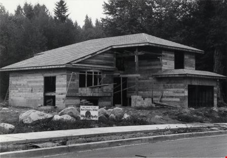
Corner of Duthie and Hewitt
https://search.heritageburnaby.ca/link/archivedescription78896
- Repository
- City of Burnaby Archives
- Date
- September 11, 1976
- Collection/Fonds
- Burnaby Public Library Contemporary Visual Archive Project
- Description Level
- Item
- Physical Description
- 1 photograph : b&w ; 11 x 16 cm mounted on cardboard
- Scope and Content
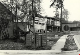
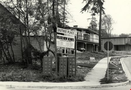
- Photograph shows a sign on the corner of Duthie Avenue and Hewitt Street advertising new homes for sale in the Duthie Place by Chivers Realty and Villa Realty, with a view of the homes in the background.
- Repository
- City of Burnaby Archives
- Date
- September 11, 1976
- Collection/Fonds
- Burnaby Public Library Contemporary Visual Archive Project
- Physical Description
- 1 photograph : b&w ; 11 x 16 cm mounted on cardboard
- Description Level
- Item
- Record No.
- 556-021
- Access Restriction
- No restrictions
- Reproduction Restriction
- Reproduce for fair dealing purposes only
- Accession Number
- 2013-13
- Scope and Content
- Photograph shows a sign on the corner of Duthie Avenue and Hewitt Street advertising new homes for sale in the Duthie Place by Chivers Realty and Villa Realty, with a view of the homes in the background.
- Media Type
- Photograph
- Notes
- Scope note taken directly from BPL photograph description.
- 5/29/2017 - Photograph Missing
- 1 b&w copy negative : 10 x 12.5 cm accompanying
- Photographers identified by surnames only: Carr and Vardeman
- Geographic Access
- Duthie Avenue
- Hewitt Street
- Historic Neighbourhood
- Lochdale (Historic Neighbourhood)
- Planning Study Area
- Lochdale Area
Images

Exterior of 1665 Sherlock Avenue
https://search.heritageburnaby.ca/link/archivedescription78949
- Repository
- City of Burnaby Archives
- Date
- October 12,1976
- Collection/Fonds
- Burnaby Public Library Contemporary Visual Archive Project
- Description Level
- Item
- Physical Description
- 1 photograph : b&w ; 11 x 16 cm mounted on cardboard
- Scope and Content
- Photograph shows the homemade sign and garden ornament at 1665 Sherlock Avenue.
- Repository
- City of Burnaby Archives
- Date
- October 12,1976
- Collection/Fonds
- Burnaby Public Library Contemporary Visual Archive Project
- Physical Description
- 1 photograph : b&w ; 11 x 16 cm mounted on cardboard
- Description Level
- Item
- Record No.
- 556-044
- Access Restriction
- No restrictions
- Reproduction Restriction
- Reproduce for fair dealing purposes only
- Accession Number
- 2013-13
- Scope and Content
- Photograph shows the homemade sign and garden ornament at 1665 Sherlock Avenue.
- Media Type
- Photograph
- Photographer
- Born, A. J.
- Notes
- Scope note taken directly from BPL photograph description.
- 1 b&w copy negative : 10 x 12.5 cm accompanying
- Geographic Access
- Sherlock Avenue
- Street Address
- 1665 Sherlock Avenue
- Historic Neighbourhood
- Lochdale (Historic Neighbourhood)
- Planning Study Area
- Lochdale Area
Images

Collapsed Shed at 6934 Kitchener Street
https://search.heritageburnaby.ca/link/archivedescription78983
- Repository
- City of Burnaby Archives
- Date
- October 4, 1976
- Collection/Fonds
- Burnaby Public Library Contemporary Visual Archive Project
- Description Level
- Item
- Physical Description
- 1 photograph : b&w ; 11 x 16 cm mounted on cardboard
- Scope and Content
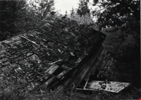
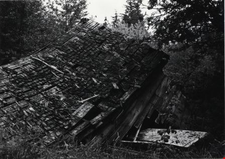
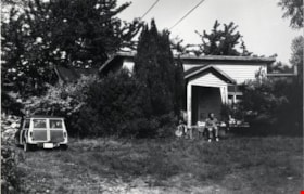
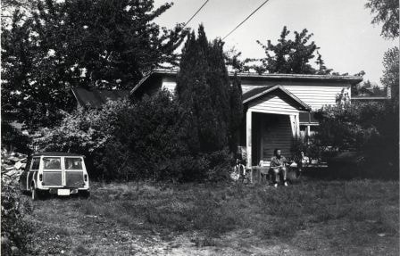
- Photograph shows an old shed which had collapsed at 6934 Kitchener Street. By December the shed was gone and a new duplex under construction on the site.
- Repository
- City of Burnaby Archives
- Date
- October 4, 1976
- Collection/Fonds
- Burnaby Public Library Contemporary Visual Archive Project
- Physical Description
- 1 photograph : b&w ; 11 x 16 cm mounted on cardboard
- Description Level
- Item
- Record No.
- 556-068
- Access Restriction
- No restrictions
- Reproduction Restriction
- Reproduce for fair dealing purposes only
- Accession Number
- 2013-13
- Scope and Content
- Photograph shows an old shed which had collapsed at 6934 Kitchener Street. By December the shed was gone and a new duplex under construction on the site.
- Media Type
- Photograph
- Photographer
- Born, A. J.
- Notes
- Scope note taken directly from BPL photograph description.
- 1 b&w copy negative : 10 x 12.5 cm accompanying
- Geographic Access
- Kitchener Street
- Street Address
- 6934 Kitchener Street
- Historic Neighbourhood
- Lochdale (Historic Neighbourhood)
- Planning Study Area
- Lochdale Area
Images
House at 7211 Curtis Street
https://search.heritageburnaby.ca/link/archivedescription78988
- Repository
- City of Burnaby Archives
- Date
- September 7, 1976
- Collection/Fonds
- Burnaby Public Library Contemporary Visual Archive Project
- Description Level
- Item
- Physical Description
- 1 photograph : b&w ; 11 x 16 cm mounted on cardboard
- Scope and Content
- Photograph shows a house at 7211 Curtis Street. The house was the headquarters for the SFU strike in 1974 as well as headquarters for PSA 7.
- Repository
- City of Burnaby Archives
- Date
- September 7, 1976
- Collection/Fonds
- Burnaby Public Library Contemporary Visual Archive Project
- Physical Description
- 1 photograph : b&w ; 11 x 16 cm mounted on cardboard
- Description Level
- Item
- Record No.
- 556-073
- Access Restriction
- No restrictions
- Reproduction Restriction
- Reproduce for fair dealing purposes only
- Accession Number
- 2013-13
- Scope and Content
- Photograph shows a house at 7211 Curtis Street. The house was the headquarters for the SFU strike in 1974 as well as headquarters for PSA 7.
- Media Type
- Photograph
- Photographer
- Born, A. J.
- Notes
- Scope note taken directly from BPL photograph description.
- 1 b&w copy negative : 10 x 12.5 cm accompanying
- Geographic Access
- Curtis Street
- Street Address
- 7211 Curtis Street
- Historic Neighbourhood
- Lochdale (Historic Neighbourhood)
- Planning Study Area
- Lochdale Area
Images
Back Lane between Blaine Avenue and Sherlock Avenue
https://search.heritageburnaby.ca/link/archivedescription78990
- Repository
- City of Burnaby Archives
- Date
- November 18, 1976
- Collection/Fonds
- Burnaby Public Library Contemporary Visual Archive Project
- Description Level
- Item
- Physical Description
- 1 photograph : b&w ; 11 x 16 cm mounted on cardboard
- Scope and Content
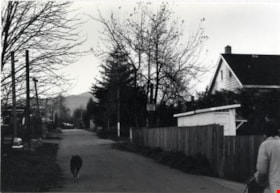
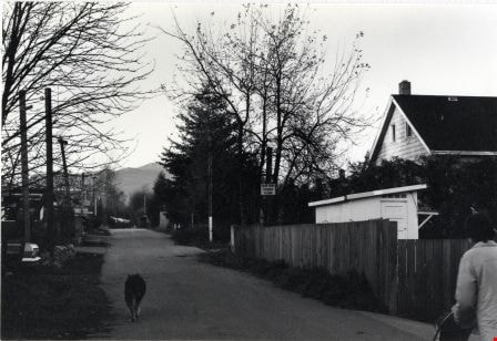
- Photograph shows a dog walking down a back lane between Blaine Avenue and Sherlock Avenue.
- Repository
- City of Burnaby Archives
- Date
- November 18, 1976
- Collection/Fonds
- Burnaby Public Library Contemporary Visual Archive Project
- Physical Description
- 1 photograph : b&w ; 11 x 16 cm mounted on cardboard
- Description Level
- Item
- Record No.
- 556-075
- Access Restriction
- No restrictions
- Reproduction Restriction
- Reproduce for fair dealing purposes only
- Accession Number
- 2013-13
- Scope and Content
- Photograph shows a dog walking down a back lane between Blaine Avenue and Sherlock Avenue.
- Media Type
- Photograph
- Photographer
- Born, A. J.
- Notes
- Scope note taken directly from BPL photograph description.
- 1 b&w copy negative : 10 x 12.5 cm accompanying
- Geographic Access
- Blaine Avenue
- Sherlock Avenue
- Historic Neighbourhood
- Lochdale (Historic Neighbourhood)
- Planning Study Area
- Lochdale Area
Images

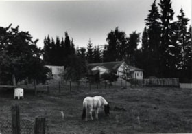
Barn at 6861 Kitchener Street
https://search.heritageburnaby.ca/link/archivedescription78995
- Repository
- City of Burnaby Archives
- Date
- October 4, 1976
- Collection/Fonds
- Burnaby Public Library Contemporary Visual Archive Project
- Description Level
- Item
- Physical Description
- 1 photograph : b&w ; 11 x 16 cm mounted on cardboard
- Scope and Content
- Photograph shows a barn and lot with a horse grazing at 6861 Kitchener Street near Cliff Avenue.
- Repository
- City of Burnaby Archives
- Date
- October 4, 1976
- Collection/Fonds
- Burnaby Public Library Contemporary Visual Archive Project
- Physical Description
- 1 photograph : b&w ; 11 x 16 cm mounted on cardboard
- Description Level
- Item
- Record No.
- 556-079
- Access Restriction
- No restrictions
- Reproduction Restriction
- Reproduce for fair dealing purposes only
- Accession Number
- 2013-13
- Scope and Content
- Photograph shows a barn and lot with a horse grazing at 6861 Kitchener Street near Cliff Avenue.
- Media Type
- Photograph
- Photographer
- Born, A. J.
- Notes
- Scope note taken directly from BPL photograph description.
- 1 b&w copy negative : 10 x 12.5 cm accompanying
- Geographic Access
- Kitchener Street
- Street Address
- 6861 Kitchener Street
- Historic Neighbourhood
- Lochdale (Historic Neighbourhood)
- Planning Study Area
- Lochdale Area
Images

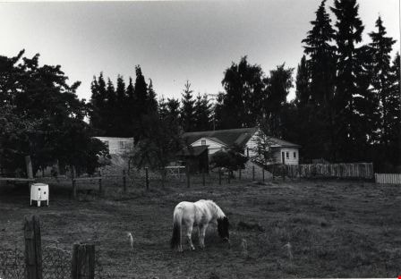
Horse Grazing at 6861 Kitchener Street
https://search.heritageburnaby.ca/link/archivedescription78996
- Repository
- City of Burnaby Archives
- Date
- October 4, 1976
- Collection/Fonds
- Burnaby Public Library Contemporary Visual Archive Project
- Description Level
- Item
- Physical Description
- 1 photograph : b&w ; 11 x 16 cm mounted on cardboard
- Scope and Content
- Photograph shows a horse grazing at 6861 Kitchener Street near Cliff Avenue.
- Repository
- City of Burnaby Archives
- Date
- October 4, 1976
- Collection/Fonds
- Burnaby Public Library Contemporary Visual Archive Project
- Physical Description
- 1 photograph : b&w ; 11 x 16 cm mounted on cardboard
- Description Level
- Item
- Record No.
- 556-080
- Access Restriction
- No restrictions
- Reproduction Restriction
- Reproduce for fair dealing purposes only
- Accession Number
- 2013-13
- Scope and Content
- Photograph shows a horse grazing at 6861 Kitchener Street near Cliff Avenue.
- Subjects
- Animals - Horses
- Media Type
- Photograph
- Photographer
- Born, A. J.
- Notes
- Scope note taken directly from BPL photograph description.
- 1 b&w copy negative : 10 x 12.5 cm accompanying
- Geographic Access
- Kitchener Street
- Street Address
- 6861 Kitchener Street
- Historic Neighbourhood
- Lochdale (Historic Neighbourhood)
- Planning Study Area
- Lochdale Area
Images
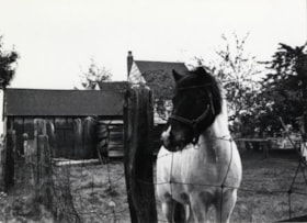
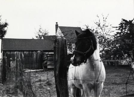
Horse at 6861 Kitchener Street
https://search.heritageburnaby.ca/link/archivedescription78997
- Repository
- City of Burnaby Archives
- Date
- October 4, 1976
- Collection/Fonds
- Burnaby Public Library Contemporary Visual Archive Project
- Description Level
- Item
- Physical Description
- 1 photograph : b&w ; 11 x 16 cm mounted on cardboard
- Scope and Content
- Photograph shows a horse, named Naylor, at 6861 Kitchener Street near Cliff Avenue. The horse was owned by an SFU student and boarded at the lot on Kitchener Street.
- Repository
- City of Burnaby Archives
- Date
- October 4, 1976
- Collection/Fonds
- Burnaby Public Library Contemporary Visual Archive Project
- Physical Description
- 1 photograph : b&w ; 11 x 16 cm mounted on cardboard
- Description Level
- Item
- Record No.
- 556-081
- Access Restriction
- No restrictions
- Reproduction Restriction
- Reproduce for fair dealing purposes only
- Accession Number
- 2013-13
- Scope and Content
- Photograph shows a horse, named Naylor, at 6861 Kitchener Street near Cliff Avenue. The horse was owned by an SFU student and boarded at the lot on Kitchener Street.
- Subjects
- Animals - Horses
- Media Type
- Photograph
- Photographer
- Born, A. J.
- Notes
- Scope note taken directly from BPL photograph description.
- 1 b&w copy negative : 10 x 12.5 cm accompanying
- Geographic Access
- Kitchener Street
- Street Address
- 6861 Kitchener Street
- Historic Neighbourhood
- Lochdale (Historic Neighbourhood)
- Planning Study Area
- Lochdale Area
Images

Home on Queenston Court
https://search.heritageburnaby.ca/link/archivedescription79002
- Repository
- City of Burnaby Archives
- Date
- September 11, 1976
- Collection/Fonds
- Burnaby Public Library Contemporary Visual Archive Project
- Description Level
- Item
- Physical Description
- 1 photograph : b&w ; 11 x 16 cm mounted on cardboard
- Scope and Content
- Photograph shows house construction in progress on a lot on Queenston Court.
- Repository
- City of Burnaby Archives
- Date
- September 11, 1976
- Collection/Fonds
- Burnaby Public Library Contemporary Visual Archive Project
- Physical Description
- 1 photograph : b&w ; 11 x 16 cm mounted on cardboard
- Description Level
- Item
- Record No.
- 556-084
- Access Restriction
- No restrictions
- Reproduction Restriction
- Reproduce for fair dealing purposes only
- Accession Number
- 2013-13
- Scope and Content
- Photograph shows house construction in progress on a lot on Queenston Court.
- Subjects
- Construction
- Media Type
- Photograph
- Notes
- Scope note taken directly from BPL photograph description.
- 1 b&w copy negative : 10 x 12.5 cm accompanying
- Photographers identified by surnames only: Carr and Vardeman
- Geographic Access
- Queenston Court
- Historic Neighbourhood
- Lochdale (Historic Neighbourhood)
- Planning Study Area
- Lochdale Area
Images

Parkcrest Bible Chapel
https://search.heritageburnaby.ca/link/archivedescription79045
- Repository
- City of Burnaby Archives
- Date
- September 7, 1976
- Collection/Fonds
- Burnaby Public Library Contemporary Visual Archive Project
- Description Level
- Item
- Physical Description
- 1 photograph : b&w ; 11 x 16 cm mounted on cardboard
- Scope and Content
- Photograph shows the Parkcrest Bible Chapel at 6641 Halifax Street. It was built in 1962.
- Repository
- City of Burnaby Archives
- Date
- September 7, 1976
- Collection/Fonds
- Burnaby Public Library Contemporary Visual Archive Project
- Physical Description
- 1 photograph : b&w ; 11 x 16 cm mounted on cardboard
- Description Level
- Item
- Record No.
- 556-112
- Access Restriction
- No restrictions
- Reproduction Restriction
- Reproduce for fair dealing purposes only
- Accession Number
- 2013-13
- Scope and Content
- Photograph shows the Parkcrest Bible Chapel at 6641 Halifax Street. It was built in 1962.
- Subjects
- Buildings - Religious - Churches
- Names
- Parkcrest Bible Chapel
- Media Type
- Photograph
- Photographer
- Born, A. J.
- Notes
- Scope note taken directly from BPL photograph description.
- 1 b&w copy negative : 10 x 12.5 cm accompanying
- Geographic Access
- Halifax Street
- Street Address
- 6641 Halifaxt Street
- Historic Neighbourhood
- Lochdale (Historic Neighbourhood)
- Planning Study Area
- Lochdale Area
Images

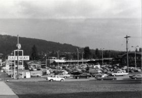
Kensington Plaza
https://search.heritageburnaby.ca/link/archivedescription79133
- Repository
- City of Burnaby Archives
- Date
- October 16, 1976
- Collection/Fonds
- Burnaby Public Library Contemporary Visual Archive Project
- Description Level
- Item
- Physical Description
- 1 photograph : b&w ; 11 x 16 cm mounted on cardboard
- Scope and Content
- Photograph shows the parking lot at the Kensington Plaza on Hastings Street at the corner of Kensington Avenue.
- Repository
- City of Burnaby Archives
- Date
- October 16, 1976
- Collection/Fonds
- Burnaby Public Library Contemporary Visual Archive Project
- Physical Description
- 1 photograph : b&w ; 11 x 16 cm mounted on cardboard
- Description Level
- Item
- Record No.
- 556-175
- Access Restriction
- No restrictions
- Reproduction Restriction
- Reproduce for fair dealing purposes only
- Accession Number
- 2013-13
- Scope and Content
- Photograph shows the parking lot at the Kensington Plaza on Hastings Street at the corner of Kensington Avenue.
- Subjects
- Buildings - Commercial - Stores
- Names
- Safeway
- Media Type
- Photograph
- Notes
- Scope note taken directly from BPL photograph description.
- 1 b&w copy negative : 10 x 12.5 cm accompanying
- Photographers identified by surnames only: Carr and Vardeman
- Geographic Access
- Hastings Street
- Street Address
- 6500 Hastings Street
- Historic Neighbourhood
- Lochdale (Historic Neighbourhood)
- Planning Study Area
- Lochdale Area
Images
