Narrow Results By
Person / Organization
- Bearn, William "Bill" 1
- Bearn, William "Bud" 1
- Bolton, Mary 1
- Bolton, Nancy 3
- British Columbia Electric Railway Company 1
- Burnaby South High School 1
- Canadian National Railway 1
- Chinese Market Gardens 1
- Christianson, Audrey Frances May Bearn 1
- Cleghorn, Edith Thrussell 1
- Clinton Elementary School 1
- Comberbach, Gladys Phillips 1
Riverside Elementary School
https://search.heritageburnaby.ca/link/archivedescription79616
- Repository
- City of Burnaby Archives
- Date
- September 23, 1976
- Collection/Fonds
- Burnaby Public Library Contemporary Visual Archive Project
- Description Level
- Item
- Physical Description
- 1 photograph : b&w ; 11 x 16 cm mounted on cardboard
- Scope and Content
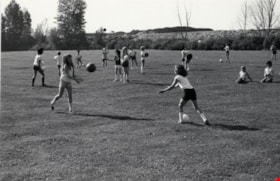
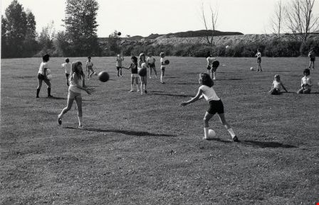
- Photograph shows children playing at Riverside Elementary School at 7855 Meadow Avenue.
- Repository
- City of Burnaby Archives
- Date
- September 23, 1976
- Collection/Fonds
- Burnaby Public Library Contemporary Visual Archive Project
- Physical Description
- 1 photograph : b&w ; 11 x 16 cm mounted on cardboard
- Description Level
- Item
- Record No.
- 556-357
- Access Restriction
- No restrictions
- Reproduction Restriction
- Reproduce for fair dealing purposes only
- Accession Number
- 2013-13
- Scope and Content
- Photograph shows children playing at Riverside Elementary School at 7855 Meadow Avenue.
- Media Type
- Photograph
- Photographer
- Campbell, Peg
- Notes
- Scope note taken directly from BPL photograph description.
- 1 b&w copy negative : 10 x 12.5 cm accompanying
- Geographic Access
- Meadow Avenue
- Street Address
- 7855 Meadow Avenue
- Historic Neighbourhood
- Fraser Arm (Historic Neighbourhood)
- Planning Study Area
- Big Bend Area
Images
Riverside Elementary School
https://search.heritageburnaby.ca/link/archivedescription79617
- Repository
- City of Burnaby Archives
- Date
- September 23, 1976
- Collection/Fonds
- Burnaby Public Library Contemporary Visual Archive Project
- Description Level
- Item
- Physical Description
- 1 photograph : b&w ; 11 x 16 cm mounted on cardboard
- Scope and Content
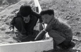
- Photograph shows children playing in a sandbox on the grounds of Riverside Elementary School at 7855 Meadow Avenue.
- Repository
- City of Burnaby Archives
- Date
- September 23, 1976
- Collection/Fonds
- Burnaby Public Library Contemporary Visual Archive Project
- Physical Description
- 1 photograph : b&w ; 11 x 16 cm mounted on cardboard
- Description Level
- Item
- Record No.
- 556-358
- Access Restriction
- No restrictions
- Reproduction Restriction
- Reproduce for fair dealing purposes only
- Accession Number
- 2013-13
- Scope and Content
- Photograph shows children playing in a sandbox on the grounds of Riverside Elementary School at 7855 Meadow Avenue.
- Media Type
- Photograph
- Photographer
- Campbell, Peg
- Notes
- Scope note taken directly from BPL photograph description.
- 1 b&w copy negative : 10 x 12.5 cm accompanying
- Geographic Access
- Meadow Avenue
- Street Address
- 7855 Meadow Avenue
- Historic Neighbourhood
- Fraser Arm (Historic Neighbourhood)
- Planning Study Area
- Big Bend Area
Images


Barn near Meadow Avenue
https://search.heritageburnaby.ca/link/archivedescription79687
- Repository
- City of Burnaby Archives
- Date
- September 23, 1976
- Collection/Fonds
- Burnaby Public Library Contemporary Visual Archive Project
- Description Level
- Item
- Physical Description
- 1 photograph : b&w ; 11 x 16 cm mounted on cardboard
- Scope and Content
- Photograph shows a boat inside an old barn near Meadow Avenue and 10th Avenue.
- Repository
- City of Burnaby Archives
- Date
- September 23, 1976
- Collection/Fonds
- Burnaby Public Library Contemporary Visual Archive Project
- Physical Description
- 1 photograph : b&w ; 11 x 16 cm mounted on cardboard
- Description Level
- Item
- Record No.
- 556-383
- Access Restriction
- No restrictions
- Reproduction Restriction
- Reproduce for fair dealing purposes only
- Accession Number
- 2013-13
- Scope and Content
- Photograph shows a boat inside an old barn near Meadow Avenue and 10th Avenue.
- Media Type
- Photograph
- Photographer
- Campbell, Peg
- Notes
- Scope note taken directly from BPL photograph description.
- 1 b&w copy negative : 10 x 12.5 cm accompanying
- Geographic Access
- Meadow Avenue
- 10th Avenue
- Historic Neighbourhood
- Fraser Arm (Historic Neighbourhood)
- Planning Study Area
- Big Bend Area
Images


Marine Way and Willard Street
https://search.heritageburnaby.ca/link/archivedescription79912
- Repository
- City of Burnaby Archives
- Date
- November, 1976
- Collection/Fonds
- Burnaby Public Library Contemporary Visual Archive Project
- Description Level
- Item
- Physical Description
- 1 photograph : b&w ; 11 x 16 cm mounted on cardboard
- Scope and Content
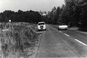
- Photograph shows a collection of signboards on the corner of Marine Way and Willard Street.
- Repository
- City of Burnaby Archives
- Date
- November, 1976
- Collection/Fonds
- Burnaby Public Library Contemporary Visual Archive Project
- Physical Description
- 1 photograph : b&w ; 11 x 16 cm mounted on cardboard
- Description Level
- Item
- Record No.
- 556-494
- Access Restriction
- No restrictions
- Reproduction Restriction
- Reproduce for fair dealing purposes only
- Accession Number
- 2013-13
- Scope and Content
- Photograph shows a collection of signboards on the corner of Marine Way and Willard Street.
- Media Type
- Photograph
- Photographer
- Campbell, Peg
- Notes
- Scope note taken directly from BPL photograph description.
- 1 b&w copy negative : 10 x 12.5 cm accompanying
- Geographic Access
- Marine Way
- Willard Street
- Historic Neighbourhood
- Fraser Arm (Historic Neighbourhood)
- Planning Study Area
- Big Bend Area
Images

Pipeline Sign
https://search.heritageburnaby.ca/link/archivedescription79925
- Repository
- City of Burnaby Archives
- Date
- October 20, 1976
- Collection/Fonds
- Burnaby Public Library Contemporary Visual Archive Project
- Description Level
- Item
- Physical Description
- 1 photograph : b&w ; 11 x 16 cm mounted on cardboard
- Scope and Content
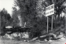
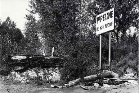
- Photograph shows a sign on the bank of the Fraser River near the end of Byrne Road, warning boaters not to anchor in the area because of a pipeline.
- Repository
- City of Burnaby Archives
- Date
- October 20, 1976
- Collection/Fonds
- Burnaby Public Library Contemporary Visual Archive Project
- Physical Description
- 1 photograph : b&w ; 11 x 16 cm mounted on cardboard
- Description Level
- Item
- Record No.
- 556-496
- Access Restriction
- No restrictions
- Reproduction Restriction
- Reproduce for fair dealing purposes only
- Accession Number
- 2013-13
- Scope and Content
- Photograph shows a sign on the bank of the Fraser River near the end of Byrne Road, warning boaters not to anchor in the area because of a pipeline.
- Media Type
- Photograph
- Photographer
- Ross, Martha
- Notes
- Scope note taken directly from BPL photograph description.
- 1 b&w copy negative : 10 x 12.5 cm accompanying
- Geographic Access
- Fraser River
- Historic Neighbourhood
- Fraser Arm (Historic Neighbourhood)
- Planning Study Area
- Big Bend Area
Images
Vacant Lot
https://search.heritageburnaby.ca/link/archivedescription79934
- Repository
- City of Burnaby Archives
- Date
- November, 1976
- Collection/Fonds
- Burnaby Public Library Contemporary Visual Archive Project
- Description Level
- Item
- Physical Description
- 1 photograph : b&w ; 11 x 16 cm mounted on cardboard
- Scope and Content
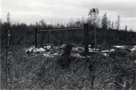
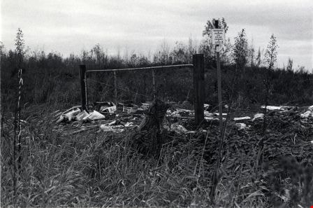
- Photograph shows a view of a fence and of garbage that has been dumped on a vacant lot near Marshland Avenue and Wiggins Street. A posted sign indicates a gas pipeline crossing.
- Repository
- City of Burnaby Archives
- Date
- November, 1976
- Collection/Fonds
- Burnaby Public Library Contemporary Visual Archive Project
- Physical Description
- 1 photograph : b&w ; 11 x 16 cm mounted on cardboard
- Description Level
- Item
- Record No.
- 556-505
- Access Restriction
- No restrictions
- Reproduction Restriction
- Reproduce for fair dealing purposes only
- Accession Number
- 2013-13
- Scope and Content
- Photograph shows a view of a fence and of garbage that has been dumped on a vacant lot near Marshland Avenue and Wiggins Street. A posted sign indicates a gas pipeline crossing.
- Media Type
- Photograph
- Photographer
- Campbell, Peg
- Notes
- Scope note taken directly from BPL photograph description.
- 1 b&w copy negative : 10 x 12.5 cm accompanying
- Geographic Access
- Wiggins Street
- Marshland Avenue
- Historic Neighbourhood
- Fraser Arm (Historic Neighbourhood)
- Planning Study Area
- Big Bend Area
Images

South Burnaby
https://search.heritageburnaby.ca/link/archivedescription79981
- Repository
- City of Burnaby Archives
- Date
- September 10, 1976
- Collection/Fonds
- Burnaby Public Library Contemporary Visual Archive Project
- Description Level
- Item
- Physical Description
- 1 photograph : b&w ; 11 x 16 cm mounted on cardboard
- Scope and Content
- Photograph shows a view of southern Burnaby looking northeast toward the railroad tracks and Marine Drive from the southern tip of Burnaby.
- Repository
- City of Burnaby Archives
- Date
- September 10, 1976
- Collection/Fonds
- Burnaby Public Library Contemporary Visual Archive Project
- Physical Description
- 1 photograph : b&w ; 11 x 16 cm mounted on cardboard
- Description Level
- Item
- Record No.
- 556-537
- Access Restriction
- No restrictions
- Reproduction Restriction
- Reproduce for fair dealing purposes only
- Accession Number
- 2013-13
- Scope and Content
- Photograph shows a view of southern Burnaby looking northeast toward the railroad tracks and Marine Drive from the southern tip of Burnaby.
- Subjects
- Aerial Photographs
- Media Type
- Photograph
- Photographer
- Ross, Martha
- Notes
- Scope note taken directly from BPL photograph description.
- 1 b&w copy negative : 10 x 12.5 cm accompanying
- Historic Neighbourhood
- Fraser Arm (Historic Neighbourhood)
- Planning Study Area
- Big Bend Area
Images

Marshland Avenue
https://search.heritageburnaby.ca/link/archivedescription79982
- Repository
- City of Burnaby Archives
- Date
- September 23, 1976
- Collection/Fonds
- Burnaby Public Library Contemporary Visual Archive Project
- Description Level
- Item
- Physical Description
- 1 photograph : b&w ; 11 x 16 cm mounted on cardboard
- Scope and Content
- Photograph shows a view looking northeast along Marshland Avenue, near Wiggins Street.
- Repository
- City of Burnaby Archives
- Date
- September 23, 1976
- Collection/Fonds
- Burnaby Public Library Contemporary Visual Archive Project
- Physical Description
- 1 photograph : b&w ; 11 x 16 cm mounted on cardboard
- Description Level
- Item
- Record No.
- 556-538
- Access Restriction
- No restrictions
- Reproduction Restriction
- Reproduce for fair dealing purposes only
- Accession Number
- 2013-13
- Scope and Content
- Photograph shows a view looking northeast along Marshland Avenue, near Wiggins Street.
- Media Type
- Photograph
- Photographer
- Campbell, Peg
- Notes
- Scope note taken directly from BPL photograph description.
- 1 b&w copy negative : 10 x 12.5 cm accompanying
- Geographic Access
- Marshland Avenue
- Historic Neighbourhood
- Fraser Arm (Historic Neighbourhood)
- Planning Study Area
- Big Bend Area
Images

Rorison family
https://search.heritageburnaby.ca/link/archivedescription87857
- Repository
- City of Burnaby Archives
- Date
- Between 1926 and 1940 (date of originals), copied [1990]
- Collection/Fonds
- Mary Forsyth fonds
- Description Level
- File
- Physical Description
- 6 photographs : b&w copy prints ; 10 x 15 cm
- Scope and Content
- Photographs of the Cropley and Rorison families near their home located at 3907 River Road (now Marine Drive) in Burnaby. The property was purchased by Matilda Cropley in 1913. Matilda married Alfred Cropley and may have lived on the property. Matilda and Alfred's daughter, Alma married William Ror…
- Repository
- City of Burnaby Archives
- Date
- Between 1926 and 1940 (date of originals), copied [1990]
- Collection/Fonds
- Mary Forsyth fonds
- Physical Description
- 6 photographs : b&w copy prints ; 10 x 15 cm
- Description Level
- File
- Record No.
- 572-001
- Access Restriction
- In Archives only
- Reproduction Restriction
- No reproduction permitted
- Accession Number
- 2014-27
- Scope and Content
- Photographs of the Cropley and Rorison families near their home located at 3907 River Road (now Marine Drive) in Burnaby. The property was purchased by Matilda Cropley in 1913. Matilda married Alfred Cropley and may have lived on the property. Matilda and Alfred's daughter, Alma married William Rorison and built their home on part of the land owned by Matilda. Alma and William had four children, Bill (William Jr.), Hugh and twin girls Kay (Kathleen) and Evelyn.
- Names
- Rorison, Marguerite
- Media Type
- Photograph
- Notes
- Title based on contents of photograph
- Date of originals noted on verso of copy print
- Captions on verso describe the photographs and identify individuals
- Historic Neighbourhood
- Fraser Arm (Historic Neighbourhood)
- Planning Study Area
- Big Bend Area
Riverway East and Riverway West Schools
https://search.heritageburnaby.ca/link/archivedescription87921
- Repository
- City of Burnaby Archives
- Date
- 1926-1967 (date of originals), copied [1990]
- Collection/Fonds
- Mary Forsyth fonds
- Description Level
- File
- Physical Description
- 24 photographs : b&w copy prints + 25 photographs : b&w negatives ; 35 mm
- Scope and Content
- Photographs of Dundonald, Riverway East, Glenwood and Riverway West schools and negatives.
- Repository
- City of Burnaby Archives
- Date
- 1926-1967 (date of originals), copied [1990]
- Collection/Fonds
- Mary Forsyth fonds
- Physical Description
- 24 photographs : b&w copy prints + 25 photographs : b&w negatives ; 35 mm
- Description Level
- File
- Record No.
- 572-002
- Access Restriction
- In Archives only
- Reproduction Restriction
- No reproduction permitted
- Accession Number
- 2014-27
- Scope and Content
- Photographs of Dundonald, Riverway East, Glenwood and Riverway West schools and negatives.
- Subjects
- Buildings - Schools
- Names
- Riverway East School
- Media Type
- Photograph
- Notes
- Title based on contents of photograph
- Most of the photographs are copy prints taken from the Riverway West PTA scrapbook MSS068-001 (Bay 64 - Shelf 6)
- Many of the photographs contain annotations on verso
- Note in pencil on verso of photograph 572-002-1 reads: "Riverway East"
- Note in pencil on verso of photograph 572-002-2 reads: "school site for/ 1) Dundonald with shed/ 2) Riverway East 1905/ 3) Glenwood"
- Note in blue pen on verso of photograph 572-002-38 reads:"back row/ Miss Kidd, Donald Kin, William Waldner, Sammy Gilbert, Lucy Checkowsky, Geraldine McIntyre, Beatrice MacGowen, Jean Banon, Dorren McClure, Sady Mann, Sonny McClure, 2 Normal Students/2nd row/Eva Eng, Florence MacGowen, Evelyn Rorison, Kay Rorison, Nelie Wilson, Jessie Gilbert, Margaret Corothers, Audrey Banon, Betty Mann, Jean MacMullin/3rd row/ Hughie Rorison, Engine Banoff, David Downs, Donald McIntyre, Fred Chambers, George Eng, Anthony Checkowsky, Jimmy Wintson, Art McClure, Leonard Geall, Jack Rorison, Peter Smith, Gum Eng."
- Historic Neighbourhood
- Fraser Arm (Historic Neighbourhood)
- Planning Study Area
- Big Bend Area

North Fraser Harbour Commission / Fraser River
https://search.heritageburnaby.ca/link/archivedescription91706
- Repository
- City of Burnaby Archives
- Date
- May 25, 1994
- Collection/Fonds
- Doreen Lawson fonds
- Description Level
- File
- Physical Description
- 40 photographs : col. slides ; 35 mm + 65 photographs : col. negatives ; 35 mm
- Scope and Content
- File consists of photographs of the Fraser River. Sawmills and industrial buildings line the banks of the river which is populated with tugboats, drifting timber rafts, and sawdust barges. Photographs were taken from a boat travelling down the river and the bow of the boat is visible in one of th…
- Repository
- City of Burnaby Archives
- Date
- May 25, 1994
- Collection/Fonds
- Doreen Lawson fonds
- Physical Description
- 40 photographs : col. slides ; 35 mm + 65 photographs : col. negatives ; 35 mm
- Description Level
- File
- Record No.
- 618-024
- Access Restriction
- No restrictions
- Reproduction Restriction
- Reproduce for fair dealing purposes only
- Accession Number
- 2015-15
- Scope and Content
- File consists of photographs of the Fraser River. Sawmills and industrial buildings line the banks of the river which is populated with tugboats, drifting timber rafts, and sawdust barges. Photographs were taken from a boat travelling down the river and the bow of the boat is visible in one of the photographs.
- Media Type
- Photograph
- Notes
- Transcribed title
- Title transcribed from label on slide sheets
- Note in blue ink on recto of slide sheets photographs 618-024-001 : 618-024-15 and 618-024-27 : 618-024-38 were originally housed in read: "May 25 94 / North Fraser Harbour Commission / Fraser River"
- Note in blue ink on recto of slide sheet photographs 618-024-16 : 618-024-26 were originally housed in reads: "May 25 94 / North Fraser Harbour Commission / Fraser River / Irene Frith"
- Note in blue ink on slide sheet photographs 618-039 : 618-039-40 originally housed in read: "Fraser River / May 25 94"
- Note in blue ink on negative envelopes reads: "Fraser River / May 25 94"
- Geographic Access
- Fraser River
- Historic Neighbourhood
- Fraser Arm (Historic Neighbourhood)
- Planning Study Area
- Big Bend Area
Images


New Haven Borstal (Barn)
https://search.heritageburnaby.ca/link/archivedescription93662
- Repository
- City of Burnaby Archives
- Date
- January 15, 1978
- Collection/Fonds
- Burnaby Public Library Contemporary Visual Archive Project
- Description Level
- Item
- Physical Description
- 1 photograph : b&w ; 12.5 x 17.5 cm
- Scope and Content
- Photograph of the exterior of the barn at the New Haven Borstal Institute, located at 4250 Marine Drive. The photograph is taken facing northeast. New Haven operated out of the Glen-Lyon Estate, which the provincial government purchased in 1939.
- Repository
- City of Burnaby Archives
- Date
- January 15, 1978
- Collection/Fonds
- Burnaby Public Library Contemporary Visual Archive Project
- Physical Description
- 1 photograph : b&w ; 12.5 x 17.5 cm
- Description Level
- Item
- Record No.
- 556-619
- Access Restriction
- No restrictions
- Reproduction Restriction
- Reproduce for fair dealing purposes only
- Accession Number
- 2017-57
- Scope and Content
- Photograph of the exterior of the barn at the New Haven Borstal Institute, located at 4250 Marine Drive. The photograph is taken facing northeast. New Haven operated out of the Glen-Lyon Estate, which the provincial government purchased in 1939.
- Subjects
- Buildings - Public - Detention Facilities
- Buildings - Schools
- Government - Provincial Government
- Buildings - Heritage
- Media Type
- Photograph
- Photographer
- Hauger, C.
- Notes
- Title taken from project information form
- Accompanied by a project information form and 1 photograph (b&w negative ; 9.5 x 12.5 cm)
- BPL no. 68
- Geographic Access
- Marine Drive
- Street Address
- 4250 Marine Drive
- Historic Neighbourhood
- Fraser Arm (Historic Neighbourhood)
- Planning Study Area
- Big Bend Area
Images


Administration Building New Haven Borstal
https://search.heritageburnaby.ca/link/archivedescription93663
- Repository
- City of Burnaby Archives
- Date
- January 15, 1978
- Collection/Fonds
- Burnaby Public Library Contemporary Visual Archive Project
- Description Level
- Item
- Physical Description
- 1 photograph : b&w ; 12.5 x 17.5 cm
- Scope and Content
- Photograph of the exterior of the administration building at the New Haven Borstal Institute. The photograph is taken from across the lawn, facing northwest. A man is looking into the window of the building on the left.
- Repository
- City of Burnaby Archives
- Date
- January 15, 1978
- Collection/Fonds
- Burnaby Public Library Contemporary Visual Archive Project
- Physical Description
- 1 photograph : b&w ; 12.5 x 17.5 cm
- Description Level
- Item
- Record No.
- 556-620
- Access Restriction
- No restrictions
- Reproduction Restriction
- Reproduce for fair dealing purposes only
- Accession Number
- 2017-57
- Scope and Content
- Photograph of the exterior of the administration building at the New Haven Borstal Institute. The photograph is taken from across the lawn, facing northwest. A man is looking into the window of the building on the left.
- Subjects
- Buildings - Public - Detention Facilities
- Buildings - Schools
- Buildings - Heritage
- Government - Provincial Government
- Media Type
- Photograph
- Photographer
- Surridge, Jack
- Notes
- Title taken from project information form
- Accompanied by a project information form and 1 photograph (b&w negative ; 9.5 x 12.5 cm)
- BPL no. 69
- Street Address
- 4520 Marine Drive
- Historic Neighbourhood
- Fraser Arm (Historic Neighbourhood)
- Planning Study Area
- Big Bend Area
Images


New Haven Borstal Main Building
https://search.heritageburnaby.ca/link/archivedescription93665
- Repository
- City of Burnaby Archives
- Date
- January 15, 1978
- Collection/Fonds
- Burnaby Public Library Contemporary Visual Archive Project
- Description Level
- Item
- Physical Description
- 1 photograph : b&w ; 12.5 x 17.5 cm
- Scope and Content
- Photograph of the side exterior of the main building of the New Haven Borstal Institute, located at 4250 Marine Drive. The main building is the old mansion of the Glen-Lyon estate, which the provincial government purchased in 1939. The photograph is taken from the sidewalk, facing northeast.
- Repository
- City of Burnaby Archives
- Date
- January 15, 1978
- Collection/Fonds
- Burnaby Public Library Contemporary Visual Archive Project
- Physical Description
- 1 photograph : b&w ; 12.5 x 17.5 cm
- Description Level
- Item
- Record No.
- 556-622
- Access Restriction
- No restrictions
- Reproduction Restriction
- Reproduce for fair dealing purposes only
- Accession Number
- 2017-57
- Scope and Content
- Photograph of the side exterior of the main building of the New Haven Borstal Institute, located at 4250 Marine Drive. The main building is the old mansion of the Glen-Lyon estate, which the provincial government purchased in 1939. The photograph is taken from the sidewalk, facing northeast.
- Subjects
- Buildings - Public - Detention Facilities
- Buildings - Schools
- Buildings - Heritage
- Government - Provincial Government
- Media Type
- Photograph
- Photographer
- Roberts, S.
- Notes
- Title taken from project information form
- Accompanied by a project information form and 1 photograph (b&w negative ; 9.5 x 12.5 cm)
- BPL no. 71
- Geographic Access
- Marine Drive
- Street Address
- 4250 Marine Drive
- Historic Neighbourhood
- Fraser Arm (Historic Neighbourhood)
- Planning Study Area
- Big Bend Area
Images


New Haven Borstal Workshop
https://search.heritageburnaby.ca/link/archivedescription93666
- Repository
- City of Burnaby Archives
- Date
- January 15, 1978
- Collection/Fonds
- Burnaby Public Library Contemporary Visual Archive Project
- Description Level
- Item
- Physical Description
- 1 photograph : b&w ; 12.5 x 17.5 cm
- Scope and Content
- Photograph of the exterior of the workshop at the New Haven Borstal Institute, located across the street from the main building at 4250 Marine Drive. The photograph is taken from across the lawn, facing northeast. Cars are parked outside the workshop and the front of the main building, previously t…
- Repository
- City of Burnaby Archives
- Date
- January 15, 1978
- Collection/Fonds
- Burnaby Public Library Contemporary Visual Archive Project
- Physical Description
- 1 photograph : b&w ; 12.5 x 17.5 cm
- Description Level
- Item
- Record No.
- 556-623
- Access Restriction
- No restrictions
- Reproduction Restriction
- Reproduce for fair dealing purposes only
- Accession Number
- 2017-57
- Scope and Content
- Photograph of the exterior of the workshop at the New Haven Borstal Institute, located across the street from the main building at 4250 Marine Drive. The photograph is taken from across the lawn, facing northeast. Cars are parked outside the workshop and the front of the main building, previously the Glen-Lyon estate mansion, is visible in the background.
- Subjects
- Buildings - Public - Detention Facilities
- Buildings - Schools
- Buildings - Heritage
- Government - Provincial Government
- Media Type
- Photograph
- Photographer
- Roberts, S.
- Notes
- Title taken from project information form
- Accompanied by a project information form and 1 photograph (b&w negative ; 9.5 x 12.5 cm)
- BPL no. 72
- Geographic Access
- Marine Drive
- Street Address
- 4250 Marine Drive
- Historic Neighbourhood
- Fraser Arm (Historic Neighbourhood)
- Planning Study Area
- Big Bend Area
Images


New Haven Borstal Main Building
https://search.heritageburnaby.ca/link/archivedescription93667
- Repository
- City of Burnaby Archives
- Date
- January 15, 1978
- Collection/Fonds
- Burnaby Public Library Contemporary Visual Archive Project
- Description Level
- Item
- Physical Description
- 1 photograph : b&w ; 12.5 x 17.5 cm
- Scope and Content
- Photograph of the side exterior of the main building of the New Haven Borstal Institute, located at 4250 Marine Drive. The main building is the old mansion of the Glen-Lyon estate, which the provincial government purchased in 1939. The photograph is taken from the sidewalk, facing northwest.
- Repository
- City of Burnaby Archives
- Date
- January 15, 1978
- Collection/Fonds
- Burnaby Public Library Contemporary Visual Archive Project
- Physical Description
- 1 photograph : b&w ; 12.5 x 17.5 cm
- Description Level
- Item
- Record No.
- 556-624
- Access Restriction
- No restrictions
- Reproduction Restriction
- Reproduce for fair dealing purposes only
- Accession Number
- 2017-57
- Scope and Content
- Photograph of the side exterior of the main building of the New Haven Borstal Institute, located at 4250 Marine Drive. The main building is the old mansion of the Glen-Lyon estate, which the provincial government purchased in 1939. The photograph is taken from the sidewalk, facing northwest.
- Subjects
- Buildings - Public - Detention Facilities
- Buildings - Schools
- Buildings - Heritage
- Government - Provincial Government
- Media Type
- Photograph
- Photographer
- Hauger, C.
- Notes
- Title taken from project information form
- Accompanied by a project information form and 1 photograph (b&w negative ; 9.5 x 12.5 cm)
- BPL no. 73
- Geographic Access
- Marine Drive
- Street Address
- 4250 Marine Drive
- Historic Neighbourhood
- Fraser Arm (Historic Neighbourhood)
- Planning Study Area
- Big Bend Area
Images

Marine Way
https://search.heritageburnaby.ca/link/archivedescription93716
- Repository
- City of Burnaby Archives
- Date
- 1987
- Collection/Fonds
- Grover, Elliott & Co. Ltd. fonds
- Description Level
- File
- Physical Description
- 24 photographs : col. negatives ; 35 mm
- Scope and Content
- Photographs of an undeveloped property along Marine Way. Property is located adjacent to railway tracks and a creek.
- Repository
- City of Burnaby Archives
- Date
- 1987
- Collection/Fonds
- Grover, Elliott & Co. Ltd. fonds
- Physical Description
- 24 photographs : col. negatives ; 35 mm
- Description Level
- File
- Record No.
- 622-005
- Access Restriction
- No restrictions
- Reproduction Restriction
- No restrictions
- Accession Number
- 2017-39
- Scope and Content
- Photographs of an undeveloped property along Marine Way. Property is located adjacent to railway tracks and a creek.
- Media Type
- Photograph
- Notes
- Transcribed title
- Title transcribed from original print envelope
- File no. 87-297-B
- Geographic Access
- Marine Way
- Historic Neighbourhood
- Fraser Arm (Historic Neighbourhood)
- Planning Study Area
- Big Bend Area
8855 Northbrook Court
https://search.heritageburnaby.ca/link/archivedescription93735
- Repository
- City of Burnaby Archives
- Date
- 1989
- Collection/Fonds
- Grover, Elliott & Co. Ltd. fonds
- Description Level
- File
- Physical Description
- 21 photographs : col. negatives ; 35 mm
- Scope and Content
- Photographs of an undeveloped property loacated at 8855 Northbrook Court. Construction equipment is visible in the distance.
- Repository
- City of Burnaby Archives
- Date
- 1989
- Collection/Fonds
- Grover, Elliott & Co. Ltd. fonds
- Physical Description
- 21 photographs : col. negatives ; 35 mm
- Description Level
- File
- Record No.
- 622-020
- Access Restriction
- No restrictions
- Reproduction Restriction
- No restrictions
- Accession Number
- 2017-39
- Scope and Content
- Photographs of an undeveloped property loacated at 8855 Northbrook Court. Construction equipment is visible in the distance.
- Media Type
- Photograph
- Notes
- Transcribed title
- Title transcribed from original print envelope
- File no. 89-037-B
- Geographic Access
- Northbrook Court
- Street Address
- 8855 Northbrook Court
- Historic Neighbourhood
- Fraser Arm (Historic Neighbourhood)
- Planning Study Area
- Big Bend Area
North Fraser Way / Northbrook Court
https://search.heritageburnaby.ca/link/archivedescription93736
- Repository
- City of Burnaby Archives
- Date
- 1989
- Collection/Fonds
- Grover, Elliott & Co. Ltd. fonds
- Description Level
- File
- Physical Description
- 16 photographs : col. negatives ; 35 mm
- Scope and Content
- Photographs of an undeveloped property loacated at the corner of North Fraser Way and Northbrook Court.
- Repository
- City of Burnaby Archives
- Date
- 1989
- Collection/Fonds
- Grover, Elliott & Co. Ltd. fonds
- Physical Description
- 16 photographs : col. negatives ; 35 mm
- Description Level
- File
- Record No.
- 622-021
- Access Restriction
- No restrictions
- Reproduction Restriction
- No restrictions
- Accession Number
- 2017-39
- Scope and Content
- Photographs of an undeveloped property loacated at the corner of North Fraser Way and Northbrook Court.
- Subjects
- Land Clearing
- Geographic Features - Roads
- Media Type
- Photograph
- Notes
- Transcribed title
- Title transcribed from original print envelope
- File no. 89-040-B
- Geographic Access
- Northbrook Court
- North Fraser Way
- Historic Neighbourhood
- Fraser Arm (Historic Neighbourhood)
- Planning Study Area
- Big Bend Area
5324 Thorne Ave
https://search.heritageburnaby.ca/link/archivedescription93762
- Repository
- City of Burnaby Archives
- Date
- June 12, 1992
- Collection/Fonds
- Grover, Elliott & Co. Ltd. fonds
- Description Level
- File
- Physical Description
- 120 photographs : col. negatives ; 35 mm
- Scope and Content
- Photographs of an industrial property located at 5324 Thorne Avenue - an address than no longer exists.
- Repository
- City of Burnaby Archives
- Date
- June 12, 1992
- Collection/Fonds
- Grover, Elliott & Co. Ltd. fonds
- Physical Description
- 120 photographs : col. negatives ; 35 mm
- Description Level
- File
- Record No.
- 622-047
- Access Restriction
- No restrictions
- Reproduction Restriction
- No restrictions
- Accession Number
- 2017-39
- Scope and Content
- Photographs of an industrial property located at 5324 Thorne Avenue - an address than no longer exists.
- Subjects
- Buildings - Industrial
- Media Type
- Photograph
- Notes
- Transcribed title
- Title transcribed from envelope photographs were originally housed in
- File no. 92-224-I
- Note adhered to 622-047-001 print reads: "11 / The manufacturing plant [illegible], southwest from the northweast corner of the site".
- Note adhered to 622-047-5 print reads: "17 / view south along the east side of the property from Thorne Avenue".
- Note adhered to 622-047-9 print reads: "18 / The canopy at loading area and shed addition of the [illegible] and of the building".
- Note adhered to 622-047-13 print reads: "19 / View of the interior of the building looking towards to west".
- Note adhered to 622-047-17 print reads: "23 / view east across the site immediately south of the building".
- Note adhered to 622-047-21 print reads: "22 / view looking north west twoards the south facade".
- Note adhered to 622-047-25 print reads: "8 / The freestanding office building adjacent to Thorne Avenue and Wiggins Street".
- Note adhered to 622-047-29 print reads: "9 / View of its front entr [sid] and the office building".
- Note adhered to 622-047-33 reads: "10 / View west towards the office building from the main vehicle entr [sic] at Thorne Avenue".
- Note adhered to 622-047-37 print reads: "14 / View east across the north yard area".
- Note adhered to 622-047-41 print reads: "12 / View of the north facade looking south."
- Note adhered to 622-047-45 print reads: "13 / View west across the north yard area".
- Note adhered to 622-047-49 print reads: "20 / The [illegible] building".
- Note adhered to 622-047-53 print reads: "26 / View northeast from the west property line".
- Note adhered to 622-047-57 print reads: "21 / View looking northeast at the south facade".
- Note adhered to 622-047-61 print reads: "16 / View north along the west side of the manufacturing building".
- Note adhered to 622-047-65 print reads: "15 / View of the north west corner of the manufacturing building".
- Note adhered to 622-047-69 print reads: "3 / View west along Thorne Avenue from the east side of the property".
- Note adhered to 622-047-73 print reads: "25 / View north from the southeast corner of the property".
- Note adhered to 622-047-77 print reads: "30 / View of the dock looking southeast from the property".
- Note adhered to 622-047-81 print reads: "24 / View north from the southwest corner of the property".
- Note adhered to 622-047-85 print reads: "27 / The barge dock at the southwest corner of the site".
- Note adhered to 622-047-89 print reads: "29 / View east along the river front".
- Note adhered to 622-047-93 print reads: "28 / View of the dolphins and mooring area".
- Note adhered to 622-047-97 print reads: "4 / View west along [illegible] Avenue past the entrance to the north parking lot".
- Note adhered to 622-047-101 print reads: "2 / View southwest from Thorne Avenue".
- Note adhered to 622-047-105 print reads: "5 / View west across the north parking lot".
- Note adhered to 622-047-113 print reads: "6 / View southeast from the north parking lot".
- Photographer identified as "D.E."
- Geographic Access
- Thorne Avenue
- Historic Neighbourhood
- Fraser Arm (Historic Neighbourhood)
- Planning Study Area
- Big Bend Area