Narrow Results By
Creator
- Bartel, Mario 23
- British Columbia Underwriters' Association 3
- Burnaby Village Museum 1
- Burnett, Geoffrey K. 3
- Burnett & McGugan, Engineers and Surveyors 1
- Cheung, Nakita 2
- Cooksley, William Thomas 3
- Disney, John Harold "Jack" 4
- Finley, Martha, 1828-1909 9
- Garden, Hermon and Burwell 1
- Hodge, Craig 1
- Jones, Charles Spurgeon "Chuck" 1
![Rob Recuenco in Premiere League baseball game, [2001] thumbnail](/media/hpo/_Data/_Archives_Images/_Unrestricted/535/535-2304.jpg?width=280)
Rob Recuenco in Premiere League baseball game
https://search.heritageburnaby.ca/link/archivedescription96682
- Repository
- City of Burnaby Archives
- Date
- [2001]
- Collection/Fonds
- Burnaby NewsLeader photograph collection
- Description Level
- Item
- Physical Description
- 1 photograph (tiff) : col.
- Scope and Content
- Photograph of Vancouver/Burnaby Mounties batter Rob Recuenco in action during the a Premiere League baseball game against the Cowichan Valley Canadians.
- Repository
- City of Burnaby Archives
- Date
- [2001]
- Collection/Fonds
- Burnaby NewsLeader photograph collection
- Physical Description
- 1 photograph (tiff) : col.
- Description Level
- Item
- Record No.
- 535-2304
- Access Restriction
- No restrictions
- Reproduction Restriction
- No restrictions
- Accession Number
- 2018-12
- Scope and Content
- Photograph of Vancouver/Burnaby Mounties batter Rob Recuenco in action during the a Premiere League baseball game against the Cowichan Valley Canadians.
- Subjects
- Sports - Baseball
- Media Type
- Photograph
- Photographer
- Bartel, Mario
- Notes
- Title based on caption
- Collected by editorial for use in an April 2003 issue of the Burnaby NewsLeader
- Caption from metadata: "Vancouver/Burnaby Mounties' batter Rob Recuenco fouls one back in the first game of a Premiere League doubleheader against the Cowichan Valley Canadians, at Robert Burnaby Park on Saturday."
- Geographic Access
- Robert Burnaby Park
- Wedgewood Street
- Street Address
- 8155 Wedgewood Street
- Historic Neighbourhood
- East Burnaby (Historic Neighbourhood)
- Planning Study Area
- Lakeview-Mayfield Area
Images
![Rob Recuenco in Premiere League baseball game, [2001] thumbnail](/media/hpo/_Data/_Archives_Images/_Unrestricted/535/535-2304.jpg)
![Second Street Community School garden, [2000] thumbnail](/media/hpo/_Data/_Archives_Images/_Unrestricted/535/535-2425.jpg?width=280)
Second Street Community School garden
https://search.heritageburnaby.ca/link/archivedescription96867
- Repository
- City of Burnaby Archives
- Date
- [2000]
- Collection/Fonds
- Burnaby NewsLeader photograph collection
- Description Level
- Item
- Physical Description
- 1 photograph (tiff) : col.
- Scope and Content
- Photograph of students Amanda Wilkes, Chantal Vicente, and Michael Gerow in the community garden at Second Street Community School.
- Repository
- City of Burnaby Archives
- Date
- [2000]
- Collection/Fonds
- Burnaby NewsLeader photograph collection
- Physical Description
- 1 photograph (tiff) : col.
- Description Level
- Item
- Record No.
- 535-2425
- Access Restriction
- No restrictions
- Reproduction Restriction
- No restrictions
- Accession Number
- 2018-12
- Scope and Content
- Photograph of students Amanda Wilkes, Chantal Vicente, and Michael Gerow in the community garden at Second Street Community School.
- Names
- Second Street School
- Media Type
- Photograph
- Photographer
- Bartel, Mario
- Notes
- Title based on caption
- Collected by editorial for use in a May 2000 issue of the Burnaby NewsLeader
- Caption from metadata: "Amanada Wilkes plants in the garden, while Chantal Vicente and Michael Gerow enjoy a book on a park bench, in the community garden at Second Street Community School. The school recently received a provincial grant to add the benches and other features to the garden."
- Geographic Access
- 2nd Street
- Street Address
- 7502 2nd Street
- Historic Neighbourhood
- East Burnaby (Historic Neighbourhood)
- Planning Study Area
- Second Street Area
Images
![Second Street Community School garden, [2000] thumbnail](/media/hpo/_Data/_Archives_Images/_Unrestricted/535/535-2425.jpg)
![Cariboo Hill Secondary students with time capsule, [2000] thumbnail](/media/hpo/_Data/_Archives_Images/_Unrestricted/535/535-2519.jpg?width=280)
Cariboo Hill Secondary students with time capsule
https://search.heritageburnaby.ca/link/archivedescription96964
- Repository
- City of Burnaby Archives
- Date
- [2000]
- Collection/Fonds
- Burnaby NewsLeader photograph collection
- Description Level
- Item
- Physical Description
- 1 photograph (tiff) : col.
- Scope and Content
- Photograph of Cariboo Hill Secondary School grade 12 students Ashley Graystone, Carmel Challenger, Elizabeth Bell, and Jessica Smith in a classroom viewing the contents for the school's time capsule. Graystone is reading a copy of the Time Millennium Collector's Edition.
- Repository
- City of Burnaby Archives
- Date
- [2000]
- Collection/Fonds
- Burnaby NewsLeader photograph collection
- Physical Description
- 1 photograph (tiff) : col.
- Description Level
- Item
- Record No.
- 535-2519
- Access Restriction
- No restrictions
- Reproduction Restriction
- No restrictions
- Accession Number
- 2018-12
- Scope and Content
- Photograph of Cariboo Hill Secondary School grade 12 students Ashley Graystone, Carmel Challenger, Elizabeth Bell, and Jessica Smith in a classroom viewing the contents for the school's time capsule. Graystone is reading a copy of the Time Millennium Collector's Edition.
- Subjects
- Persons - Students
- Artifacts
- Media Type
- Photograph
- Photographer
- Bartel, Mario
- Notes
- Title based on caption
- Collected by editorial for use in a June 2000 issue of the Burnaby NewsLeader
- Caption from metadata: "Ashley Graystone reviews the century, while Carmel Challenger, Elizabeth Bell, and Jessica Smith, all grade 12 students at Cariboo High School, check out some of the items that will be placed in a time capsule in the school's front hall, to be opened in 50 years."
- Geographic Access
- 16th Avenue
- Street Address
- 8580 16th Avenue
- Historic Neighbourhood
- East Burnaby (Historic Neighbourhood)
- Planning Study Area
- Cariboo-Armstrong Area
Images
![Cariboo Hill Secondary students with time capsule, [2000] thumbnail](/media/hpo/_Data/_Archives_Images/_Unrestricted/535/535-2519.jpg)
![Robin Bridge at Robert Burnaby Park pool, [2000] thumbnail](/media/hpo/_Data/_Archives_Images/_Unrestricted/535/535-2553.jpg?width=280)
Robin Bridge at Robert Burnaby Park pool
https://search.heritageburnaby.ca/link/archivedescription97021
- Repository
- City of Burnaby Archives
- Date
- [2000]
- Collection/Fonds
- Burnaby NewsLeader photograph collection
- Description Level
- Item
- Physical Description
- 1 photograph (tiff) : col.
- Scope and Content
- Photograph of Robin Bridge, a Burnaby RCMP officer, sitting on the diving board at the Robert Burnaby Park pool, to promote the Friday night "Dive-In" for youth.
- Repository
- City of Burnaby Archives
- Date
- [2000]
- Collection/Fonds
- Burnaby NewsLeader photograph collection
- Physical Description
- 1 photograph (tiff) : col.
- Description Level
- Item
- Record No.
- 535-2553
- Access Restriction
- No restrictions
- Reproduction Restriction
- No restrictions
- Accession Number
- 2018-12
- Scope and Content
- Photograph of Robin Bridge, a Burnaby RCMP officer, sitting on the diving board at the Robert Burnaby Park pool, to promote the Friday night "Dive-In" for youth.
- Media Type
- Photograph
- Photographer
- Bartel, Mario
- Notes
- Title based on caption
- Collected by editorial for use in a July 2000 issue of the Burnaby NewsLeader
- Caption from metadata: "Robin Bridge, of the Burnaby RCMP, is one of the ornganizers of the Friday night Dive-In for youth at the outdoor pool at Robert Burnaby Park. Bridge says it's hoped the program will give young people a sense of "ownership," of the pool, and cut down on vandalism and break-ins."
- Geographic Access
- Robert Burnaby Park
- Wedgewood Street
- Street Address
- 8175 Wedgewood Street
- Historic Neighbourhood
- East Burnaby (Historic Neighbourhood)
- Planning Study Area
- Lakeview-Mayfield Area
Images
![Robin Bridge at Robert Burnaby Park pool, [2000] thumbnail](/media/hpo/_Data/_Archives_Images/_Unrestricted/535/535-2553.jpg)
![Armstrong Elementary school supplies drive, [2000] thumbnail](/media/hpo/_Data/_Archives_Images/_Unrestricted/535/535-3096.jpg?width=280)
Armstrong Elementary school supplies drive
https://search.heritageburnaby.ca/link/archivedescription97992
- Repository
- City of Burnaby Archives
- Date
- [2000]
- Collection/Fonds
- Burnaby NewsLeader photograph collection
- Description Level
- Item
- Physical Description
- 1 photograph (tiff) : col.
- Scope and Content
- Photograph of Armstrong Elementary School students Eugenia Wu and Candice Bachra in a classroom sorting through school supplies that were collected by students.
- Repository
- City of Burnaby Archives
- Date
- [2000]
- Collection/Fonds
- Burnaby NewsLeader photograph collection
- Physical Description
- 1 photograph (tiff) : col.
- Description Level
- Item
- Record No.
- 535-3096
- Access Restriction
- No restrictions
- Reproduction Restriction
- No restrictions
- Accession Number
- 2018-12
- Scope and Content
- Photograph of Armstrong Elementary School students Eugenia Wu and Candice Bachra in a classroom sorting through school supplies that were collected by students.
- Names
- Armstrong Avenue School
- Media Type
- Photograph
- Photographer
- Bartel, Mario
- Notes
- Title based on caption
- Collected by editorial for use in a February 2000 issue of the Burnaby NewsLeader
- Caption from metadata: "Eugenia Wu, 9, and Candice Bachra, 10, sort through some of the school supplies collected by students at Armstrong Elementary, to be sent to refugee children in Bosnia."
- Geographic Access
- Armstrong Avenue
- Street Address
- 8757 Armstrong Avenue
- Historic Neighbourhood
- East Burnaby (Historic Neighbourhood)
- Planning Study Area
- Cariboo-Armstrong Area
Images
![Armstrong Elementary school supplies drive, [2000] thumbnail](/media/hpo/_Data/_Archives_Images/_Unrestricted/535/535-3096.jpg)
![Paul Martin at Lee Rankin campaign event, [2000] thumbnail](/media/hpo/_Data/_Archives_Images/_Unrestricted/535/535-1666.jpg?width=280)
Paul Martin at Lee Rankin campaign event
https://search.heritageburnaby.ca/link/archivedescription95866
- Repository
- City of Burnaby Archives
- Date
- [2000]
- Collection/Fonds
- Burnaby NewsLeader photograph collection
- Description Level
- Item
- Physical Description
- 1 photograph (tiff) : col.
- Scope and Content
- Photograph of Paul Martin speaking in the gymnasium of Cariboo Secondary School to an audience of high school students seated on folding chairs. Martin appeared during a campaign event for Liberal candidate Lee Rankin.
- Repository
- City of Burnaby Archives
- Date
- [2000]
- Collection/Fonds
- Burnaby NewsLeader photograph collection
- Physical Description
- 1 photograph (tiff) : col.
- Description Level
- Item
- Record No.
- 535-1666
- Access Restriction
- No restrictions
- Reproduction Restriction
- No restrictions
- Accession Number
- 2018-12
- Scope and Content
- Photograph of Paul Martin speaking in the gymnasium of Cariboo Secondary School to an audience of high school students seated on folding chairs. Martin appeared during a campaign event for Liberal candidate Lee Rankin.
- Subjects
- Elections
- Officials - Elected Officials
- Media Type
- Photograph
- Photographer
- Bartel, Mario
- Notes
- Title based on caption
- Collected by editorial for use in a November 2000 issue of the Burnaby NewsLeader
- Caption from metadata: "Federal finance minister Paul Martin, speaks with senior students at Cariboo Secondary, during a campaign appearance for Liberal candidate Lee Rankin."
- Geographic Access
- 16th Avenue
- Street Address
- 8580 16th Avenue
- Historic Neighbourhood
- East Burnaby (Historic Neighbourhood)
- Planning Study Area
- Cariboo-Armstrong Area
Images
![Paul Martin at Lee Rankin campaign event, [2000] thumbnail](/media/hpo/_Data/_Archives_Images/_Unrestricted/535/535-1666.jpg)
![Robert Burnaby Park pool, [1999] thumbnail](/media/hpo/_Data/_Archives_Images/_Unrestricted/535/535-3176.jpg?width=280)
Robert Burnaby Park pool
https://search.heritageburnaby.ca/link/archivedescription98096
- Repository
- City of Burnaby Archives
- Date
- [1999]
- Collection/Fonds
- Burnaby NewsLeader photograph collection
- Description Level
- Item
- Physical Description
- 1 photograph (tiff) : col.
- Scope and Content
- Photograph of City of Burnaby worker Bill Klingenberg painting the bottom of the Robert Burnaby Park outdoor swimming pool in preparation for its season opening.
- Repository
- City of Burnaby Archives
- Date
- [1999]
- Collection/Fonds
- Burnaby NewsLeader photograph collection
- Physical Description
- 1 photograph (tiff) : col.
- Description Level
- Item
- Record No.
- 535-3176
- Access Restriction
- No restrictions
- Reproduction Restriction
- No restrictions
- Accession Number
- 2018-12
- Scope and Content
- Photograph of City of Burnaby worker Bill Klingenberg painting the bottom of the Robert Burnaby Park outdoor swimming pool in preparation for its season opening.
- Media Type
- Photograph
- Photographer
- Bartel, Mario
- Notes
- Title based on caption
- Collected by editorial for use in a May 1999 issue of the Burnaby NewsLeader
- Caption from metadata: "Bill Klingenberg applies some of the 40 gallons of paint it will take to cover the bottom of the pool at Robert Burnaby Park. City of Burnaby workers are busy getting the city's four outdoor pools ready for their official opening on the Victoria Day weekend."
- Geographic Access
- Robert Burnaby Park
- Wedgewood Street
- Street Address
- 8175 Wedgewood Street
- Historic Neighbourhood
- East Burnaby (Historic Neighbourhood)
- Planning Study Area
- Lakeview-Mayfield Area
Images
![Robert Burnaby Park pool, [1999] thumbnail](/media/hpo/_Data/_Archives_Images/_Unrestricted/535/535-3176.jpg)
![Second Street School banners, [1999] thumbnail](/media/hpo/_Data/_Archives_Images/_Unrestricted/535/535-3247.jpg?width=280)
Second Street School banners
https://search.heritageburnaby.ca/link/archivedescription98169
- Repository
- City of Burnaby Archives
- Date
- [1999]
- Collection/Fonds
- Burnaby NewsLeader photograph collection
- Description Level
- Item
- Physical Description
- 1 photograph (tiff) : col.
- Scope and Content
- Photograph of an Brian Sarginson, of the City of Burnaby Engineering Department, installing banners depicting birds and a growing garden on a streetlight by Second Street School. The banners were painted by students and local artist Joanne Folks.
- Repository
- City of Burnaby Archives
- Date
- [1999]
- Collection/Fonds
- Burnaby NewsLeader photograph collection
- Physical Description
- 1 photograph (tiff) : col.
- Description Level
- Item
- Record No.
- 535-3247
- Access Restriction
- No restrictions
- Reproduction Restriction
- No restrictions
- Accession Number
- 2018-12
- Scope and Content
- Photograph of an Brian Sarginson, of the City of Burnaby Engineering Department, installing banners depicting birds and a growing garden on a streetlight by Second Street School. The banners were painted by students and local artist Joanne Folks.
- Names
- Second Street School
- Media Type
- Photograph
- Photographer
- Bartel, Mario
- Notes
- Title based on caption
- Collected by editorial for use in a July 1999 issue of the Burnaby NewsLeader
- Caption from metadata: "Brian Sarginson, of Burnaby's Engineering Department, hangs some of the eight banners designed and painted by students at Second Ave. Community School, with a little guidance from local artist, Joanne Folks."
- Geographic Access
- 2nd Street
- Street Address
- 7502 2nd Street
- Historic Neighbourhood
- East Burnaby (Historic Neighbourhood)
- Planning Study Area
- Second Street Area
Images
![Second Street School banners, [1999] thumbnail](/media/hpo/_Data/_Archives_Images/_Unrestricted/535/535-3247.jpg)
7465 Mulberry Place
https://search.heritageburnaby.ca/link/archivedescription94305
- Repository
- City of Burnaby Archives
- Date
- February 1994
- Collection/Fonds
- Grover, Elliott & Co. Ltd. fonds
- Description Level
- File
- Physical Description
- 22 photographs : col. negatives ; 35 mm
- Scope and Content
- Photographs of an undeveloped, forested property located at 7465 Mulberry Place.
- Repository
- City of Burnaby Archives
- Date
- February 1994
- Collection/Fonds
- Grover, Elliott & Co. Ltd. fonds
- Physical Description
- 22 photographs : col. negatives ; 35 mm
- Description Level
- File
- Record No.
- 622-090
- Access Restriction
- No restrictions
- Reproduction Restriction
- No restrictions
- Accession Number
- 2017-39
- Scope and Content
- Photographs of an undeveloped, forested property located at 7465 Mulberry Place.
- Subjects
- Geographic Features - Forests
- Media Type
- Photograph
- Notes
- Transcribed title
- Title transcribed from envelope photographs were originally housed in
- File no. 94-051-B
- Photographer identified as "J.C."
- Geographic Access
- Mulberry Place
- Street Address
- 7465 Mulberry Place
- Historic Neighbourhood
- East Burnaby (Historic Neighbourhood)
- Planning Study Area
- Cariboo-Armstrong Area

6742 Walker Avenue
https://search.heritageburnaby.ca/link/archivedescription37864
- Repository
- City of Burnaby Archives
- Date
- 1990 (date of original), copied 1991
- Collection/Fonds
- Burnaby Historical Society fonds
- Description Level
- Item
- Physical Description
- 1 photograph : b&w ; 3.2 x 4.8 cm print on contact sheet 20.4 x 26.7 cm
- Scope and Content
- Photograph of 6742 Walker Avenue, taken in the summer of 1990.
- Repository
- City of Burnaby Archives
- Date
- 1990 (date of original), copied 1991
- Collection/Fonds
- Burnaby Historical Society fonds
- Subseries
- Burnaby Image Bank subseries
- Physical Description
- 1 photograph : b&w ; 3.2 x 4.8 cm print on contact sheet 20.4 x 26.7 cm
- Description Level
- Item
- Record No.
- 370-452
- Access Restriction
- No restrictions
- Reproduction Restriction
- No restrictions
- Accession Number
- BHS1999-03
- Scope and Content
- Photograph of 6742 Walker Avenue, taken in the summer of 1990.
- Subjects
- Buildings - Residential - Houses
- Media Type
- Photograph
- Notes
- Title based on contents of photograph
- 1 b&w copy negative accompanying
- Negative has a pink cast
- Copied from col. photograph
- Geographic Access
- Walker Avenue
- Street Address
- 6742 Walker Avenue
- Historic Neighbourhood
- East Burnaby (Historic Neighbourhood)
- Planning Study Area
- Richmond Park Area
Images

8357 Tenth Avenue, 8350 and 8353 Eleventh Avenue
https://search.heritageburnaby.ca/link/archivedescription93724
- Repository
- City of Burnaby Archives
- Date
- 1989
- Collection/Fonds
- Grover, Elliott & Co. Ltd. fonds
- Description Level
- File
- Physical Description
- 24 photographs : col. negatives ; 35 mm
- Scope and Content
- Photographs of the exterior of the low-rise apartment complex located at 8357 10th Avenue and 8350 and 8353 11th Avenue and the laneway running between the buildings.
- Repository
- City of Burnaby Archives
- Date
- 1989
- Collection/Fonds
- Grover, Elliott & Co. Ltd. fonds
- Physical Description
- 24 photographs : col. negatives ; 35 mm
- Description Level
- File
- Record No.
- 622-013
- Access Restriction
- No restrictions
- Reproduction Restriction
- No restrictions
- Accession Number
- 2017-39
- Scope and Content
- Photographs of the exterior of the low-rise apartment complex located at 8357 10th Avenue and 8350 and 8353 11th Avenue and the laneway running between the buildings.
- Media Type
- Photograph
- Notes
- Transcribed title
- Title transcribed from original print envelope
- Geographic Access
- 10th Avenue
- 11th Avenue
- Street Address
- 8357 10th Avenue
- 8350 11th Avenue
- 8353 11th Avenue
- Historic Neighbourhood
- East Burnaby (Historic Neighbourhood)
- Planning Study Area
- Cariboo-Armstrong Area
7818 6th Street
https://search.heritageburnaby.ca/link/archivedescription93731
- Repository
- City of Burnaby Archives
- Date
- 1989
- Collection/Fonds
- Grover, Elliott & Co. Ltd. fonds
- Description Level
- File
- Physical Description
- 26 photographs : col. negatives ; 35 mm
- Scope and Content
- Photographs of the exterior of a Benjamin Moore Paints store and surrounding area. The store is located on a corner opposite Microtel and outside the store, a sign for the Skytrain Operations and Maintenance Centre is visible.
- Repository
- City of Burnaby Archives
- Date
- 1989
- Collection/Fonds
- Grover, Elliott & Co. Ltd. fonds
- Physical Description
- 26 photographs : col. negatives ; 35 mm
- Description Level
- File
- Record No.
- 622-019
- Access Restriction
- No restrictions
- Reproduction Restriction
- No restrictions
- Accession Number
- 2017-39
- Scope and Content
- Photographs of the exterior of a Benjamin Moore Paints store and surrounding area. The store is located on a corner opposite Microtel and outside the store, a sign for the Skytrain Operations and Maintenance Centre is visible.
- Media Type
- Photograph
- Notes
- Transcribed title
- Title transcribed from original print envelope
- File no. 89v-004-O
- Property address could not be confirmed at time of description.
- Geographic Access
- 6th Street
- 12th Avenue
- Street Address
- 7818 6th Street
- Historic Neighbourhood
- East Burnaby (Historic Neighbourhood)
- Planning Study Area
- Second Street Area
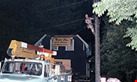
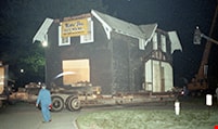
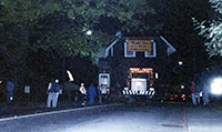
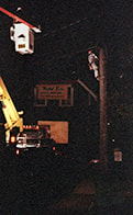
Love farmhouse move
https://search.heritageburnaby.ca/link/museumdescription10246
- Repository
- Burnaby Village Museum
- Date
- May 24, 1988
- Collection/Fonds
- Burnaby Village Museum fonds
- Description Level
- Item
- Physical Description
- 1 photograph : col. negative ; 35 mm
- Scope and Content
- Photograph of the main part of the Love farmhouse being moved at night, on the back of a flatbed truck from 7651 Cumberland Street to the site of the Burnaby Village Museum.
- Repository
- Burnaby Village Museum
- Collection/Fonds
- Burnaby Village Museum fonds
- Series
- Jesse Love farmhouse series
- Description Level
- Item
- Physical Description
- 1 photograph : col. negative ; 35 mm
- Scope and Content
- Photograph of the main part of the Love farmhouse being moved at night, on the back of a flatbed truck from 7651 Cumberland Street to the site of the Burnaby Village Museum.
- Subjects
- Buildings - Heritage
- Geographic Access
- Cumberland Street
- Street Address
- 7651 Cumberland Street
- Accession Code
- BV018.41.134
- Access Restriction
- No restrictions
- Reproduction Restriction
- No known restrictions
- Date
- May 24, 1988
- Media Type
- Photograph
- Historic Neighbourhood
- East Burnaby (Historic Neighbourhood)
- Planning Study Area
- Cariboo-Armstrong Area
- Scan Resolution
- 600
- Scan Date
- 24-Feb-19
- Scale
- 96
- Notes
- Title based on contents of photograph
- 1 col. print accompanying
Images

Love farmhouse move
https://search.heritageburnaby.ca/link/museumdescription10242
- Repository
- Burnaby Village Museum
- Date
- May 20, 1988
- Collection/Fonds
- Burnaby Village Museum fonds
- Description Level
- Item
- Physical Description
- 1 photograph : col. negative ; 35 mm
- Scope and Content
- Photograph of the roof of the Love farmhouse being moved on a flatbed truck from 7651 Cumberland Street to the site of the Burnaby Village Museum. Photo is taken at night.
- Repository
- Burnaby Village Museum
- Collection/Fonds
- Burnaby Village Museum fonds
- Series
- Jesse Love farmhouse series
- Description Level
- Item
- Physical Description
- 1 photograph : col. negative ; 35 mm
- Scope and Content
- Photograph of the roof of the Love farmhouse being moved on a flatbed truck from 7651 Cumberland Street to the site of the Burnaby Village Museum. Photo is taken at night.
- Subjects
- Buildings - Heritage
- Geographic Access
- Cumberland Street
- Street Address
- 7651 Cumberland Street
- Accession Code
- BV018.41.130
- Access Restriction
- No restrictions
- Reproduction Restriction
- No known restrictions
- Date
- May 20, 1988
- Media Type
- Photograph
- Historic Neighbourhood
- East Burnaby (Historic Neighbourhood)
- Planning Study Area
- Cariboo-Armstrong Area
- Scan Resolution
- 600
- Scan Date
- 24-Feb-19
- Scale
- 96
- Notes
- Title based on contents of photograph
- 1 col. print accompanying
Images

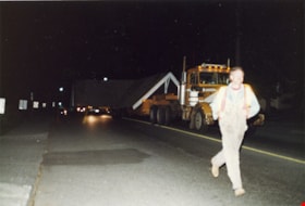
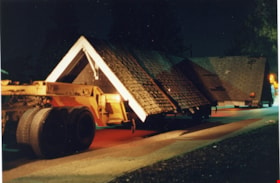
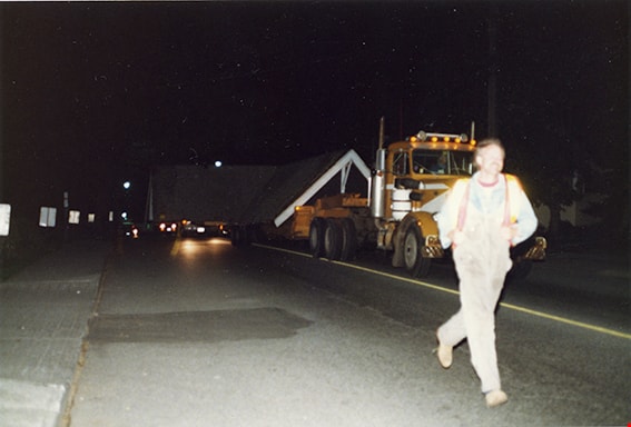
Love farmhouse move
https://search.heritageburnaby.ca/link/museumdescription10244
- Repository
- Burnaby Village Museum
- Date
- May 20, 1988
- Collection/Fonds
- Burnaby Village Museum fonds
- Description Level
- Item
- Physical Description
- 1 photograph : col. negative ; 35 mm
- Scope and Content
- Photograph of a man running in front of a flatbed truck which is transporting the rooftop of the Love farmhouse from 7651 Cumberland Street to the site of the Burnaby Village Museum. Photo is taken at night.
- Repository
- Burnaby Village Museum
- Collection/Fonds
- Burnaby Village Museum fonds
- Series
- Jesse Love farmhouse series
- Description Level
- Item
- Physical Description
- 1 photograph : col. negative ; 35 mm
- Scope and Content
- Photograph of a man running in front of a flatbed truck which is transporting the rooftop of the Love farmhouse from 7651 Cumberland Street to the site of the Burnaby Village Museum. Photo is taken at night.
- Subjects
- Buildings - Heritage
- Geographic Access
- Cumberland Street
- Street Address
- 7651 Cumberland Street
- Accession Code
- BV018.41.132
- Access Restriction
- No restrictions
- Reproduction Restriction
- No known restrictions
- Date
- May 20, 1988
- Media Type
- Photograph
- Historic Neighbourhood
- East Burnaby (Historic Neighbourhood)
- Planning Study Area
- Cariboo-Armstrong Area
- Scan Resolution
- 600
- Scan Date
- 24-Feb-19
- Scale
- 96
- Notes
- Title based on contents of photograph
- 1 col. print accompanying
Images
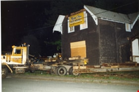
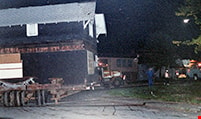
Love House moving east
https://search.heritageburnaby.ca/link/museumdescription10898
- Repository
- Burnaby Village Museum
- Date
- 20-May-88
- Collection/Fonds
- Burnaby Village Museum fonds
- Description Level
- Item
- Physical Description
- 1 photograph : col. negative ; 35 mm
- Scope and Content
- Photograph of the Love farmhouse being trucked east from it's original site at 7651 Cumberland Street across 14th Avenue. The house is on it's way to the site of the Burnaby Village Museum.
- Repository
- Burnaby Village Museum
- Collection/Fonds
- Burnaby Village Museum fonds
- Series
- Jesse Love farmhouse series
- Description Level
- Item
- Physical Description
- 1 photograph : col. negative ; 35 mm
- Material Details
- Photograph is part of Film roll "3829" - 20 colour negatives and 18 colour photographs that are a part of a collection described as BV018.41.82
- Scope and Content
- Photograph of the Love farmhouse being trucked east from it's original site at 7651 Cumberland Street across 14th Avenue. The house is on it's way to the site of the Burnaby Village Museum.
- Subjects
- Buildings - Heritage
- Geographic Access
- Cumberland Street
- Street Address
- 7651 Cumberland Street
- Accession Code
- BV018.41.420
- Access Restriction
- No restrictions
- Reproduction Restriction
- No known restrictions
- Date
- 20-May-88
- Media Type
- Photograph
- Historic Neighbourhood
- East Burnaby (Historic Neighbourhood)
- Planning Study Area
- Cariboo-Armstrong Area
- Related Material
- See BV018.41.82 for File Level Description
- Scan Resolution
- 2400
- Scan Date
- 27-May-19
- Scale
- 100
- Photographer
- Stevens, Colin
- Notes
- Title based on contents of photograph
- Photograph is a part of file level description "Photographic documentation of changes and move" BV018.41.82
Images

Love House turning south
https://search.heritageburnaby.ca/link/museumdescription10899
- Repository
- Burnaby Village Museum
- Date
- 20-May-88
- Collection/Fonds
- Burnaby Village Museum fonds
- Description Level
- Item
- Physical Description
- 1 photograph : col. negative ; 35 mm
- Scope and Content
- Photograph of the Love farmhouse turning south off 14th Avenue onto Cumberland Street, from it's original site at 7651 Cumberland Street across 14th Avenue. The house is on it's way to the site of the Burnaby Village Museum.
- Repository
- Burnaby Village Museum
- Collection/Fonds
- Burnaby Village Museum fonds
- Series
- Jesse Love farmhouse series
- Description Level
- Item
- Physical Description
- 1 photograph : col. negative ; 35 mm
- Material Details
- Photograph is part of Film roll "3829" - 20 colour negatives and 18 colour photographs that are a part of a collection described as BV018.41.82
- Scope and Content
- Photograph of the Love farmhouse turning south off 14th Avenue onto Cumberland Street, from it's original site at 7651 Cumberland Street across 14th Avenue. The house is on it's way to the site of the Burnaby Village Museum.
- Subjects
- Buildings - Heritage
- Geographic Access
- Cumberland Street
- Street Address
- 7651 Cumberland Street
- Accession Code
- BV018.41.421
- Access Restriction
- No restrictions
- Reproduction Restriction
- No known restrictions
- Date
- 20-May-88
- Media Type
- Photograph
- Historic Neighbourhood
- East Burnaby (Historic Neighbourhood)
- Planning Study Area
- Cariboo-Armstrong Area
- Related Material
- See BV018.41.82 for File Level Description
- Scan Resolution
- 2400
- Scan Date
- 27-May-19
- Scale
- 100
- Photographer
- Stevens, Colin
- Notes
- Title based on contents of photograph
- Photograph is a part of file level description "Photographic documentation of changes and move" BV018.41.82
Images
Love House move
https://search.heritageburnaby.ca/link/museumdescription10900
- Repository
- Burnaby Village Museum
- Date
- 20-May-88
- Collection/Fonds
- Burnaby Village Museum fonds
- Description Level
- Item
- Physical Description
- 1 photograph : col. negative ; 35 mm
- Scope and Content
- Photograph of the Love farmhouse going south on Cumberland from it's original site at 7651 Cumberland Street across 14th Avenue.
- Repository
- Burnaby Village Museum
- Collection/Fonds
- Burnaby Village Museum fonds
- Series
- Jesse Love farmhouse series
- Description Level
- Item
- Physical Description
- 1 photograph : col. negative ; 35 mm
- Material Details
- Photograph is part of Film roll "3829" - 20 colour negatives and 18 colour photographs that are a part of a collection described as BV018.41.82
- Scope and Content
- Photograph of the Love farmhouse going south on Cumberland from it's original site at 7651 Cumberland Street across 14th Avenue.
- Subjects
- Buildings - Heritage
- Geographic Access
- Cumberland Street
- Street Address
- 7651 Cumberland Street
- Accession Code
- BV018.41.422
- Access Restriction
- No restrictions
- Reproduction Restriction
- No known restrictions
- Date
- 20-May-88
- Media Type
- Photograph
- Historic Neighbourhood
- East Burnaby (Historic Neighbourhood)
- Planning Study Area
- Cariboo-Armstrong Area
- Related Material
- See BV018.41.82 for File Level Description
- Scan Resolution
- 2400
- Scan Date
- 27-May-19
- Scale
- 100
- Photographer
- Stevens, Colin
- Notes
- Title based on contents of photograph
- Photograph is a part of file level description "Photographic documentation of changes and move" BV018.41.82
Images

Love House going South on Cumberland Street
https://search.heritageburnaby.ca/link/museumdescription10901
- Repository
- Burnaby Village Museum
- Date
- 20-May-88
- Collection/Fonds
- Burnaby Village Museum fonds
- Description Level
- Item
- Physical Description
- 1 photograph : col. negative ; 35 mm
- Scope and Content
- Photograph of the Love farmhouse going south on Cumberland Street as it is moved from 7651 Cumberland Street to the site of the Burnaby Village Museum.
- Repository
- Burnaby Village Museum
- Collection/Fonds
- Burnaby Village Museum fonds
- Series
- Jesse Love farmhouse series
- Description Level
- Item
- Physical Description
- 1 photograph : col. negative ; 35 mm
- Material Details
- Photograph is part of Film roll "3829" - 20 colour negatives and 18 colour photographs that are a part of a collection described as BV018.41.82
- Scope and Content
- Photograph of the Love farmhouse going south on Cumberland Street as it is moved from 7651 Cumberland Street to the site of the Burnaby Village Museum.
- Subjects
- Buildings - Heritage
- Geographic Access
- Cumberland Street
- Street Address
- 7651 Cumberland Street
- Accession Code
- BV018.41.423
- Access Restriction
- No restrictions
- Reproduction Restriction
- No known restrictions
- Date
- 20-May-88
- Media Type
- Photograph
- Historic Neighbourhood
- East Burnaby (Historic Neighbourhood)
- Planning Study Area
- Cariboo-Armstrong Area
- Related Material
- See BV018.41.82 for File Level Description
- Scan Resolution
- 2400
- Scan Date
- 27-May-19
- Scale
- 100
- Photographer
- Stevens, Colin
- Notes
- Title based on contents of photograph
- Photograph is a part of file level description "Photographic documentation of changes and move" BV018.41.82
Images


Love House going South on Cumberland Street
https://search.heritageburnaby.ca/link/museumdescription10902
- Repository
- Burnaby Village Museum
- Date
- 20-May-88
- Collection/Fonds
- Burnaby Village Museum fonds
- Description Level
- Item
- Physical Description
- 1 photograph : col. negative ; 35 mm
- Scope and Content
- Photograph of the Love farmhouse going south on Cumberland Street as it is moved from 7651 Cumberland Street to the site of the Burnaby Village Museum.
- Repository
- Burnaby Village Museum
- Collection/Fonds
- Burnaby Village Museum fonds
- Series
- Jesse Love farmhouse series
- Description Level
- Item
- Physical Description
- 1 photograph : col. negative ; 35 mm
- Material Details
- Photograph is part of Film roll "3829" - 20 colour negatives and 18 colour photographs that are a part of a collection described as BV018.41.82
- Scope and Content
- Photograph of the Love farmhouse going south on Cumberland Street as it is moved from 7651 Cumberland Street to the site of the Burnaby Village Museum.
- Subjects
- Buildings - Heritage
- Geographic Access
- Cumberland Street
- Street Address
- 7651 Cumberland Street
- Accession Code
- BV018.41.424
- Access Restriction
- No restrictions
- Reproduction Restriction
- No known restrictions
- Date
- 20-May-88
- Media Type
- Photograph
- Historic Neighbourhood
- East Burnaby (Historic Neighbourhood)
- Planning Study Area
- Cariboo-Armstrong Area
- Related Material
- See BV018.41.82 for File Level Description
- Scan Resolution
- 2400
- Scan Date
- 27-May-19
- Scale
- 100
- Photographer
- Stevens, Colin
- Notes
- Title based on contents of photograph
- Photograph is a part of file level description "Photographic documentation of changes and move" BV018.41.82
Images