Narrow Results By
Subject
- Advertising Medium - Signs and Signboards 4
- Aerial Photographs 11
- Agricultural Tools and Equipment 2
- Agriculture - Farms 6
- Animals - Dogs 1
- Arts 2
- Buildings - Commercial - Grocery Stores 1
- Buildings - Commercial - Malls 9
- Buildings - Commercial - Restaurants 1
- Buildings - Commercial - Stores 2
- Buildings - Commercial - Train Stations 1
- Buildings - Recreational - Gymnasiums 1
North Road
https://search.heritageburnaby.ca/link/archivedescription79983
- Repository
- City of Burnaby Archives
- Date
- September 22, 1976
- Collection/Fonds
- Burnaby Public Library Contemporary Visual Archive Project
- Description Level
- Item
- Physical Description
- 1 photograph : b&w ; 11 x 16 cm mounted on cardboard
- Scope and Content
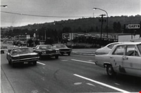
- Photograph shows a view of North Road looking southwest toward Burnaby from Austin Road.
- Repository
- City of Burnaby Archives
- Date
- September 22, 1976
- Collection/Fonds
- Burnaby Public Library Contemporary Visual Archive Project
- Physical Description
- 1 photograph : b&w ; 11 x 16 cm mounted on cardboard
- Description Level
- Item
- Record No.
- 556-539
- Access Restriction
- No restrictions
- Reproduction Restriction
- Reproduce for fair dealing purposes only
- Accession Number
- 2013-13
- Scope and Content
- Photograph shows a view of North Road looking southwest toward Burnaby from Austin Road.
- Media Type
- Photograph
- Photographer
- Campbell, Peg
- Notes
- Scope note taken directly from BPL photograph description.
- 1 b&w copy negative : 10 x 12.5 cm accompanying
- Geographic Access
- North Road
- Historic Neighbourhood
- Burquitlam (Historic Neighbourhood)
- Planning Study Area
- Cameron Area
Images

![North Road near Lougheed Highway, [1914] thumbnail](/media/hpo/_Data/_BVM_Images/1971/197200110014.jpg?width=280)
North Road near Lougheed Highway
https://search.heritageburnaby.ca/link/museumdescription3100
- Repository
- Burnaby Village Museum
- Date
- [1914]
- Collection/Fonds
- Burnaby Village Museum Photograph collection
- Description Level
- Item
- Physical Description
- 1 photograph : b&w glass negative ; 15.7 x 19.8 cm
- Scope and Content
- Photograph of a paved road lined with electric poles on both sides and a wood plank sidewalk on one side of the road. There are two men in suits on the left, in the distance. Also visible are houses to the right. An earlier catalogue record from 1988 conjectures that the photograph is a view of No…
- Repository
- Burnaby Village Museum
- Collection/Fonds
- Burnaby Village Museum Photograph collection
- Description Level
- Item
- Physical Description
- 1 photograph : b&w glass negative ; 15.7 x 19.8 cm
- Scope and Content
- Photograph of a paved road lined with electric poles on both sides and a wood plank sidewalk on one side of the road. There are two men in suits on the left, in the distance. Also visible are houses to the right. An earlier catalogue record from 1988 conjectures that the photograph is a view of North Road near the modern day intersection of Lougheed Highway, looking south to New Westminster. The record also dates the negative, ca. 1914.
- Subjects
- Geographic Features - Roads
- Geographic Access
- North Road
- Lougheed Highway
- Accession Code
- HV972.11.14
- Access Restriction
- No restrictions
- Reproduction Restriction
- No known restrictions
- Date
- [1914]
- Media Type
- Photograph
- Historic Neighbourhood
- Burquitlam (Historic Neighbourhood)
- Planning Study Area
- Cameron Area
- Related Material
- 600 dpi .TIF scan of master copy contact sheet image available at Q:\51305 BVM Collections\BVM Photographs\1970
- Scan Resolution
- 300
- Scan Date
- 14/8/2006
- Scale
- 100
- Notes
- Title based on contents of photograph
- 1 b&w contact print accompanying negative
Images
![North Road near Lougheed Highway, [1914] thumbnail](/media/hpo/_Data/_BVM_Images/1971/197200110014.jpg)

Opening of Lougheed Mall
https://search.heritageburnaby.ca/link/archivedescription37401
- Repository
- City of Burnaby Archives
- Date
- September 1969
- Collection/Fonds
- Burnaby Historical Society fonds
- Description Level
- Item
- Physical Description
- 1 photograph : b&w ; 17.9 x 23 cm
- Scope and Content
- Photograph of Burnaby Mayor Robert Prittie, with Miss PNE, Patsy McPhee, cutting the ribbon at the opening of Lougheed Mall (now Lougheed Town Centre).
- Repository
- City of Burnaby Archives
- Date
- September 1969
- Collection/Fonds
- Burnaby Historical Society fonds
- Subseries
- Robert Prittie subseries
- Physical Description
- 1 photograph : b&w ; 17.9 x 23 cm
- Description Level
- Item
- Record No.
- 368-002
- Access Restriction
- No restrictions
- Reproduction Restriction
- Reproduce for fair dealing purposes only
- Accession Number
- BHS1999-01
- Scope and Content
- Photograph of Burnaby Mayor Robert Prittie, with Miss PNE, Patsy McPhee, cutting the ribbon at the opening of Lougheed Mall (now Lougheed Town Centre).
- Media Type
- Photograph
- Photographer
- LeBlanc, Don
- Notes
- Title based on contents of photograph
- Geographic Access
- Austin Road
- Street Address
- 9855 Austin Avenue
- Historic Neighbourhood
- Burquitlam (Historic Neighbourhood)
- Planning Study Area
- Cameron Area
Images

Protestors
https://search.heritageburnaby.ca/link/archivedescription45370
- Repository
- City of Burnaby Archives
- Date
- June 1982
- Collection/Fonds
- Columbian Newspaper collection
- Description Level
- Item
- Physical Description
- 1 photograph : b&w ; 18.5 x 18.5 cm
- Scope and Content
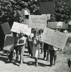
- Photograph of protesters from the Save Love's Park Committee carrying homemade signs, some of which read; "No more concrete needed here", "Make Love a Park, not a warehouse" and "People first, fish second, buildings never." This area east of Gaglardi Way and north of the Brunette River, had Love's …
- Repository
- City of Burnaby Archives
- Date
- June 1982
- Collection/Fonds
- Columbian Newspaper collection
- Physical Description
- 1 photograph : b&w ; 18.5 x 18.5 cm
- Description Level
- Item
- Record No.
- 480-265
- Access Restriction
- No restrictions
- Reproduction Restriction
- No restrictions
- Accession Number
- 2003-02
- Scope and Content
- Photograph of protesters from the Save Love's Park Committee carrying homemade signs, some of which read; "No more concrete needed here", "Make Love a Park, not a warehouse" and "People first, fish second, buildings never." This area east of Gaglardi Way and north of the Brunette River, had Love's kennel on it, and had been idenified by Burnaby as a potential park site in 1966 but Imperial Ventures wanted to develop it at as a warehouse complex.
- Subjects
- Protests and Demonstrations
- Media Type
- Photograph
- Photographer
- Hodge, Craig
- Notes
- Title based on contents of photograph
- Geographic Access
- Brunette River
- Gaglardi Way
- Historic Neighbourhood
- Burquitlam (Historic Neighbourhood)
- Planning Study Area
- Cameron Area
Images


Stormont Overpass
https://search.heritageburnaby.ca/link/archivedescription45376
- Repository
- City of Burnaby Archives
- Date
- August 1978
- Collection/Fonds
- Columbian Newspaper collection
- Description Level
- Item
- Physical Description
- 1 photograph : b&w ; 12.5 x 24 cm
- Scope and Content
- Aerial photograph of Stormont Overpass which would provide a direct link from the Trans Canada Highway (previously named the 401 Freeway) to the Lougheed Highway and Simon Fraser University. This was taken when the excavation work was completed, and grading and paving still need to be done.
- Repository
- City of Burnaby Archives
- Date
- August 1978
- Collection/Fonds
- Columbian Newspaper collection
- Physical Description
- 1 photograph : b&w ; 12.5 x 24 cm
- Description Level
- Item
- Record No.
- 480-271
- Access Restriction
- No restrictions
- Reproduction Restriction
- No restrictions
- Accession Number
- 2003-02
- Scope and Content
- Aerial photograph of Stormont Overpass which would provide a direct link from the Trans Canada Highway (previously named the 401 Freeway) to the Lougheed Highway and Simon Fraser University. This was taken when the excavation work was completed, and grading and paving still need to be done.
- Media Type
- Photograph
- Photographer
- Hodge, Craig
- Notes
- Title based on contents of photograph
- Note in pencil on verso of photograph reads: "Altair Aviation / photo by / Craig Hodge"
- Geographic Access
- Cariboo Road
- Gaglardi Way
- Trans Canada Highway
- Historic Neighbourhood
- Burquitlam (Historic Neighbourhood)
- Planning Study Area
- Burnaby Lake Area
- Cameron Area
Images


Stormont Overpass
https://search.heritageburnaby.ca/link/archivedescription45377
- Repository
- City of Burnaby Archives
- Date
- August 1978
- Collection/Fonds
- Columbian Newspaper collection
- Description Level
- Item
- Physical Description
- 1 photograph : b&w ; 16.5 x 24 cm
- Scope and Content
- Aerial photograph of Stormont Overpass which would provide a direct link from the 401 Freeway to the Lougheed Highway and Simon Fraser University. This was taken when the excavation work was completed, and grading and paving still need to be done.
- Repository
- City of Burnaby Archives
- Date
- August 1978
- Collection/Fonds
- Columbian Newspaper collection
- Physical Description
- 1 photograph : b&w ; 16.5 x 24 cm
- Description Level
- Item
- Record No.
- 480-272
- Access Restriction
- No restrictions
- Reproduction Restriction
- No restrictions
- Accession Number
- 2003-02
- Scope and Content
- Aerial photograph of Stormont Overpass which would provide a direct link from the 401 Freeway to the Lougheed Highway and Simon Fraser University. This was taken when the excavation work was completed, and grading and paving still need to be done.
- Media Type
- Photograph
- Photographer
- Hodge, Craig
- Notes
- Title based on contents of photograph
- Newspaper clipping attached to verso of photograph reads: "After six years, work on the Stormont interchange in Burnaby is only a few weeks from completion. The huge clover-leaf junction of Gaglardi Way and the Freeway is on the top left-hand corner, with Gaglardi Way approaching from the bottom right where a bridge has been completed over the Burlington Northern tracks. An embankment linking that bridge with one over the Brunette River awaits only a layer of tarmac, and a path has been cleared through the woods to link up with the clover-leaf. The present access to the Freeway is along the road running from the left to right across the middle of the picture. The interchange will open next month."
- Note in pencil on verso of photograph reads: "Altair Aviation / photo by / Craig Hodge"
- Geographic Access
- Cariboo Road
- Gaglardi Way
- Trans Canada Highway
- Historic Neighbourhood
- Burquitlam (Historic Neighbourhood)
- Planning Study Area
- Burnaby Lake Area
- Cameron Area
Images

![Cariboo Cloverleaf, Government Road and Gaglardi Way, [1978] thumbnail](/media/hpo/_Data/_Archives_Images/_Unrestricted/480/480-274.jpg?width=280)
Cariboo Cloverleaf, Government Road and Gaglardi Way
https://search.heritageburnaby.ca/link/archivedescription45379
- Repository
- City of Burnaby Archives
- Date
- [1978]
- Collection/Fonds
- Columbian Newspaper collection
- Description Level
- Item
- Physical Description
- 1 photograph : b&w ; 22.5 x 19 cm
- Scope and Content
- Aerial photograph of the Cariboo Cloverleaf, and the Government Road overpass construction that would join it with Gaglardi Way.
- Repository
- City of Burnaby Archives
- Date
- [1978]
- Collection/Fonds
- Columbian Newspaper collection
- Physical Description
- 1 photograph : b&w ; 22.5 x 19 cm
- Description Level
- Item
- Record No.
- 480-274
- Access Restriction
- No restrictions
- Reproduction Restriction
- No restrictions
- Accession Number
- 2003-02
- Scope and Content
- Aerial photograph of the Cariboo Cloverleaf, and the Government Road overpass construction that would join it with Gaglardi Way.
- Media Type
- Photograph
- Photographer
- King, Basil
- Notes
- Title based on contents of photograph
- Note on recto of photograph reads: "Cariboo cloverleaf in foreground and Government Road overpass construction (centre) will join with Gaglardi Way (top of pic)."
- Geographic Access
- Government Road
- Cariboo Road
- Gaglardi Way
- Historic Neighbourhood
- Burquitlam (Historic Neighbourhood)
- Planning Study Area
- Burnaby Lake Area
- Cariboo-Armstrong Area
- Cameron Area
Images
![Cariboo Cloverleaf, Government Road and Gaglardi Way, [1978] thumbnail](/media/hpo/_Data/_Archives_Images/_Unrestricted/480/480-274.jpg)
![Stormont Overpass, [1978] thumbnail](/media/hpo/_Data/_Archives_Images/_Unrestricted/480/480-275.jpg?width=280)
Stormont Overpass
https://search.heritageburnaby.ca/link/archivedescription45380
- Repository
- City of Burnaby Archives
- Date
- [1978]
- Collection/Fonds
- Columbian Newspaper collection
- Description Level
- Item
- Physical Description
- 1 photograph : b&w ; 16 x 24 cm
- Scope and Content
- Aerial photograph of Stormont Overpass which would provide a direct link from the Trans Canada Highway (previously named the 401 Freeway) to the Lougheed Highway and Simon Fraser University. This was taken when the excavation work was completed, and paving still need to be done.
- Repository
- City of Burnaby Archives
- Date
- [1978]
- Collection/Fonds
- Columbian Newspaper collection
- Physical Description
- 1 photograph : b&w ; 16 x 24 cm
- Description Level
- Item
- Record No.
- 480-275
- Access Restriction
- No restrictions
- Reproduction Restriction
- No restrictions
- Accession Number
- 2003-02
- Scope and Content
- Aerial photograph of Stormont Overpass which would provide a direct link from the Trans Canada Highway (previously named the 401 Freeway) to the Lougheed Highway and Simon Fraser University. This was taken when the excavation work was completed, and paving still need to be done.
- Media Type
- Photograph
- Photographer
- King, Basil
- Notes
- Title based on contents of photograph
- Note on verso of photograph reads: "One of the biggest Highways"
- Geographic Access
- Cariboo Road
- Gaglardi Way
- Trans Canada Highway
- Historic Neighbourhood
- Burquitlam (Historic Neighbourhood)
- Planning Study Area
- Burnaby Lake Area
- Cameron Area
Images
![Stormont Overpass, [1978] thumbnail](/media/hpo/_Data/_Archives_Images/_Unrestricted/480/480-275.jpg)
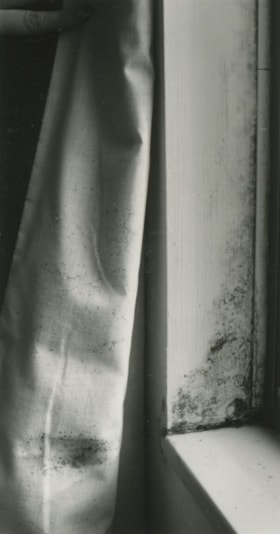
Mold along a window ledge
https://search.heritageburnaby.ca/link/archivedescription45397
- Repository
- City of Burnaby Archives
- Date
- 1977
- Collection/Fonds
- Columbian Newspaper collection
- Description Level
- Item
- Physical Description
- 1 photograph : b&w ; 14.5 x 5 cm
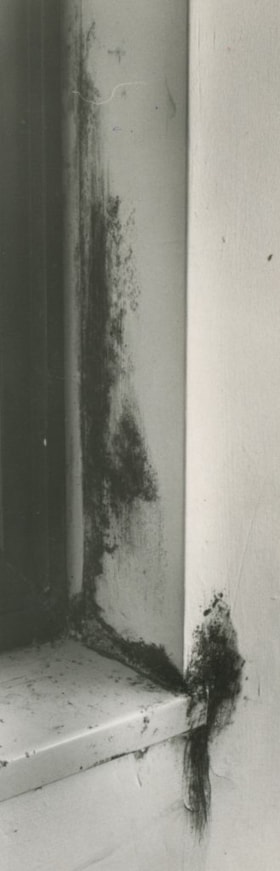
- Scope and Content
- Photograph of mold along a window ledge in a suite in MacInnis Place. After discovering the exessive build up of moisture, home owners protested against the Housing Cooperation of British Columbia (HSBC) and won; HSBC offered to buy back units from owners who were unhappy with their suites.
- Repository
- City of Burnaby Archives
- Date
- 1977
- Collection/Fonds
- Columbian Newspaper collection
- Physical Description
- 1 photograph : b&w ; 14.5 x 5 cm
- Description Level
- Item
- Record No.
- 480-292
- Access Restriction
- No restrictions
- Reproduction Restriction
- No restrictions
- Accession Number
- 2003-02
- Scope and Content
- Photograph of mold along a window ledge in a suite in MacInnis Place. After discovering the exessive build up of moisture, home owners protested against the Housing Cooperation of British Columbia (HSBC) and won; HSBC offered to buy back units from owners who were unhappy with their suites.
- Names
- MacInnis Place
- Media Type
- Photograph
- Photographer
- Battistoni, Peter
- Notes
- Title based on contents of photograph
- Geographic Access
- Keswick Avenue
- Historic Neighbourhood
- Burquitlam (Historic Neighbourhood)
- Planning Study Area
- Cameron Area
Images
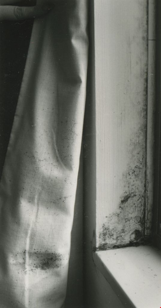
Mold along a window ledge
https://search.heritageburnaby.ca/link/archivedescription45398
- Repository
- City of Burnaby Archives
- Date
- 1977
- Collection/Fonds
- Columbian Newspaper collection
- Description Level
- Item
- Physical Description
- 1 photograph : b&w ; 9 x 5 cm
- Scope and Content
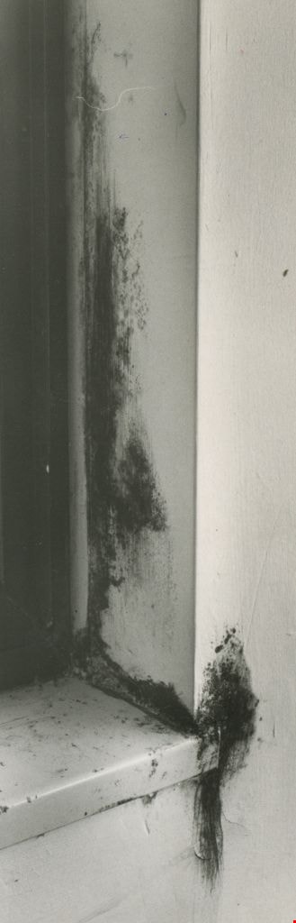
- Photograph of mold along a window ledge and curtain in a suite in MacInnis Place. After discovering the exessive build up of moisture, home owners protested against the Housing Cooperation of British Columbia (HSBC) and won; HSBC offered to buy back units from owners who were unhappy with their sui…
- Repository
- City of Burnaby Archives
- Date
- 1977
- Collection/Fonds
- Columbian Newspaper collection
- Physical Description
- 1 photograph : b&w ; 9 x 5 cm
- Description Level
- Item
- Record No.
- 480-293
- Access Restriction
- No restrictions
- Reproduction Restriction
- No restrictions
- Accession Number
- 2003-02
- Scope and Content
- Photograph of mold along a window ledge and curtain in a suite in MacInnis Place. After discovering the exessive build up of moisture, home owners protested against the Housing Cooperation of British Columbia (HSBC) and won; HSBC offered to buy back units from owners who were unhappy with their suites.
- Names
- MacInnis Place
- Media Type
- Photograph
- Photographer
- Battistoni, Peter
- Notes
- Title based on contents of photograph
- Geographic Access
- Keswick Avenue
- Historic Neighbourhood
- Burquitlam (Historic Neighbourhood)
- Planning Study Area
- Cameron Area
Images

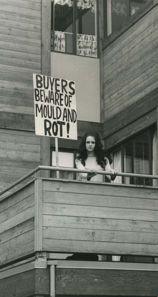
Buyers beware of mold and rot!
https://search.heritageburnaby.ca/link/archivedescription45399
- Repository
- City of Burnaby Archives
- Date
- 1977
- Collection/Fonds
- Columbian Newspaper collection
- Description Level
- Item
- Physical Description
- 1 photograph : b&w ; 18 x 9.5 cm
- Scope and Content
- Photograph of Pamela Williams standing on the balcony of her apartment beside a large protest sign which reads: "BUYERS BEWARE OF MOLD AND ROT!". She and her husband bought a suite in MacInnis Place, and after discovering the exessive build up of moisture, protested against the Housing Cooperation…
- Repository
- City of Burnaby Archives
- Date
- 1977
- Collection/Fonds
- Columbian Newspaper collection
- Physical Description
- 1 photograph : b&w ; 18 x 9.5 cm
- Description Level
- Item
- Record No.
- 480-294
- Access Restriction
- No restrictions
- Reproduction Restriction
- No restrictions
- Accession Number
- 2003-02
- Scope and Content
- Photograph of Pamela Williams standing on the balcony of her apartment beside a large protest sign which reads: "BUYERS BEWARE OF MOLD AND ROT!". She and her husband bought a suite in MacInnis Place, and after discovering the exessive build up of moisture, protested against the Housing Cooperation of British Columbia (HSBC) and won; HSBC offered to buy back units from owners who were unhappy with their suites.
- Subjects
- Protests and Demonstrations
- Media Type
- Photograph
- Photographer
- Battistoni, Peter
- Notes
- Title based on contents of photograph
- Newspaper clipping attached to verso of photograph reads: " Pamela Williams ... sign says it all."
- Geographic Access
- Keswick Avenue
- Historic Neighbourhood
- Burquitlam (Historic Neighbourhood)
- Planning Study Area
- Cameron Area
Images
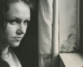
Moldy window ledge
https://search.heritageburnaby.ca/link/archivedescription45400
- Repository
- City of Burnaby Archives
- Date
- 1977
- Collection/Fonds
- Columbian Newspaper collection
- Description Level
- Item
- Physical Description
- 1 photograph : b&w ; 8 x 9.5 cm
- Scope and Content
- Photograph of Pamela Williams standing inside her apartment beside a mouldy window ledge. She and her husband bought a suite in MacInnis Place, and after discovering the exessive build up of moisture, protested against the Housing Cooperation of British Columbia (HSBC) and won; HSBC offered to buy …
- Repository
- City of Burnaby Archives
- Date
- 1977
- Collection/Fonds
- Columbian Newspaper collection
- Physical Description
- 1 photograph : b&w ; 8 x 9.5 cm
- Description Level
- Item
- Record No.
- 480-295
- Access Restriction
- No restrictions
- Reproduction Restriction
- No restrictions
- Accession Number
- 2003-02
- Scope and Content
- Photograph of Pamela Williams standing inside her apartment beside a mouldy window ledge. She and her husband bought a suite in MacInnis Place, and after discovering the exessive build up of moisture, protested against the Housing Cooperation of British Columbia (HSBC) and won; HSBC offered to buy back units from owners who were unhappy with their suites.
- Media Type
- Photograph
- Photographer
- Battistoni, Peter
- Notes
- Title based on contents of photograph
- Geographic Access
- Keswick Avenue
- Historic Neighbourhood
- Burquitlam (Historic Neighbourhood)
- Planning Study Area
- Cameron Area
Images

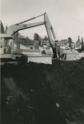
Construction of MacInnis Place
https://search.heritageburnaby.ca/link/archivedescription45401
- Repository
- City of Burnaby Archives
- Date
- 1975
- Collection/Fonds
- Columbian Newspaper collection
- Description Level
- Item
- Physical Description
- 1 photograph : b&w ; 21 x 14.5 cm
- Scope and Content
- Photograph of caterpiliar operator Casey Logan moving a large pile of earth to build a sound barrier for the British Columbia government housing project at MacInnis Place.
- Repository
- City of Burnaby Archives
- Date
- 1975
- Collection/Fonds
- Columbian Newspaper collection
- Physical Description
- 1 photograph : b&w ; 21 x 14.5 cm
- Description Level
- Item
- Record No.
- 480-296
- Access Restriction
- No restrictions
- Reproduction Restriction
- Reproduce for fair dealing purposes only
- Accession Number
- 2003-02
- Scope and Content
- Photograph of caterpiliar operator Casey Logan moving a large pile of earth to build a sound barrier for the British Columbia government housing project at MacInnis Place.
- Names
- MacInnis Place
- Media Type
- Photograph
- Notes
- Title based on contents of photograph
- Newspaper clipping attached to verso of photograph reads: "BIG BARRIER Mountain of earth is moved by 'cat' operator Casey Logan to build a sound barrier for the new B.C. government housing project at MacInnis Place in Burnaby."
- Geographic Access
- Keswick Avenue
- Historic Neighbourhood
- Burquitlam (Historic Neighbourhood)
- Planning Study Area
- Cameron Area
Images
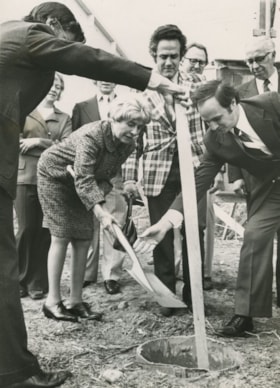
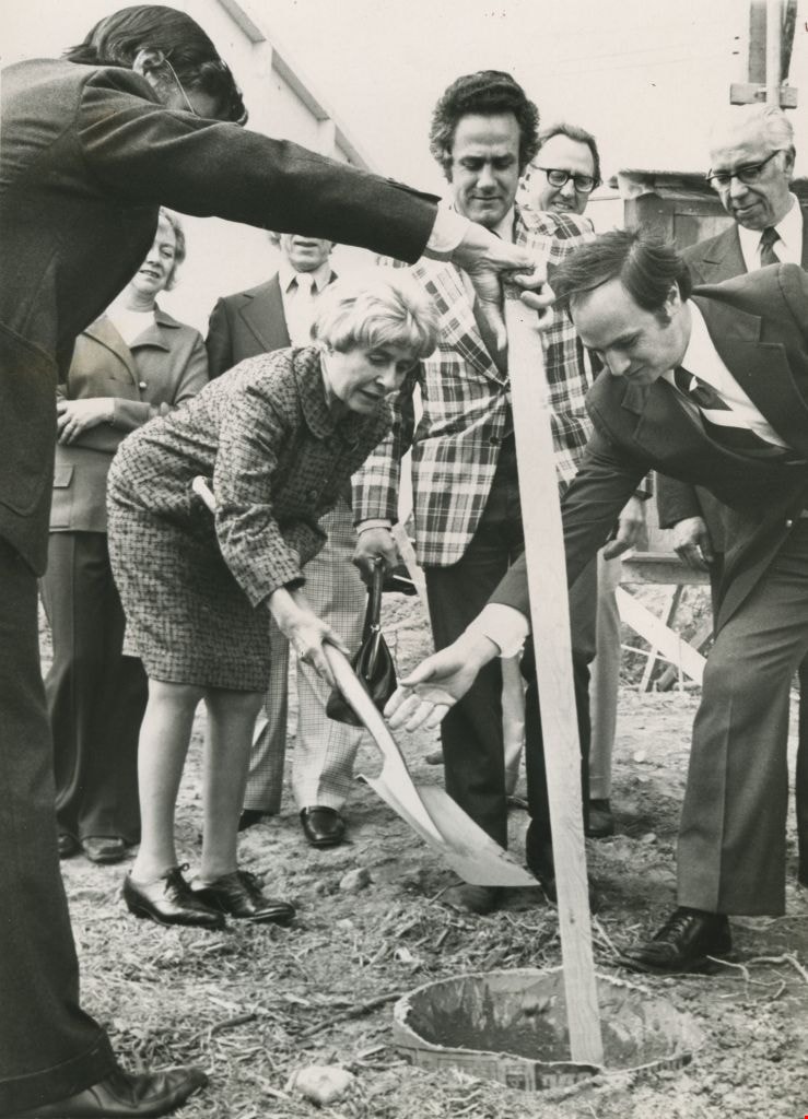
Grace MacInnis
https://search.heritageburnaby.ca/link/archivedescription45402
- Repository
- City of Burnaby Archives
- Date
- May 1975
- Collection/Fonds
- Columbian Newspaper collection
- Description Level
- Item
- Physical Description
- 1 photograph : b&w ;19.5 x 14 cm
- Scope and Content
- Photograph of former Member of Parliament Grace MacInnis burying the time capsule at the official sod turning Friday for the government -owned MacInnis housing complex. Housing Minister Lorne Nicolson and Member of the Legislative Assembly Gordon Dowding were also in attendance.
- Repository
- City of Burnaby Archives
- Date
- May 1975
- Collection/Fonds
- Columbian Newspaper collection
- Physical Description
- 1 photograph : b&w ;19.5 x 14 cm
- Description Level
- Item
- Record No.
- 480-297
- Access Restriction
- No restrictions
- Reproduction Restriction
- No restrictions
- Accession Number
- 2003-02
- Scope and Content
- Photograph of former Member of Parliament Grace MacInnis burying the time capsule at the official sod turning Friday for the government -owned MacInnis housing complex. Housing Minister Lorne Nicolson and Member of the Legislative Assembly Gordon Dowding were also in attendance.
- Subjects
- Officials - Elected Officials
- Media Type
- Photograph
- Photographer
- King, Basil
- Notes
- Title based on contents of photograph
- Newspaper clipping attached to verso of photograph reads: "Former MP Grace MacInnis buries the time capsule at the official sod turning Friday for the government -owned MacInnis housing complex on Government Road [sic] in Burnaby. Keeping a close eye on the ceremony are Housing Minister Lorne Nicolson and MLA Gordon Dowding, speaker of the House. The complex is to be called MacInnes Place and is a B.C. government comprehensive housing project."
- Geographic Access
- Keswick Avenue
- Historic Neighbourhood
- Burquitlam (Historic Neighbourhood)
- Planning Study Area
- Cameron Area
Images

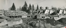
MacInnis Place and Lougheed Village
https://search.heritageburnaby.ca/link/archivedescription45407
- Repository
- City of Burnaby Archives
- Date
- March 1976
- Collection/Fonds
- Columbian Newspaper collection
- Description Level
- Item
- Physical Description
- 1 photograph : b&w ; 14 x 19.5 cm
- Scope and Content
- Aerial photograph of MacInnis Place with Lougheed Village in behind. MacInnis Place housing development was constructed with the intent of having 25% of its suites rented at a reduced cost to low income earners.
- Repository
- City of Burnaby Archives
- Date
- March 1976
- Collection/Fonds
- Columbian Newspaper collection
- Physical Description
- 1 photograph : b&w ; 14 x 19.5 cm
- Description Level
- Item
- Record No.
- 480-302
- Access Restriction
- No restrictions
- Reproduction Restriction
- No restrictions
- Accession Number
- 2003-02
- Scope and Content
- Aerial photograph of MacInnis Place with Lougheed Village in behind. MacInnis Place housing development was constructed with the intent of having 25% of its suites rented at a reduced cost to low income earners.
- Subjects
- Aerial Photographs
- Media Type
- Photograph
- Photographer
- King, Basil
- Notes
- Title based on contents of photograph
- Historic Neighbourhood
- Burquitlam (Historic Neighbourhood)
- Planning Study Area
- Cameron Area
Images

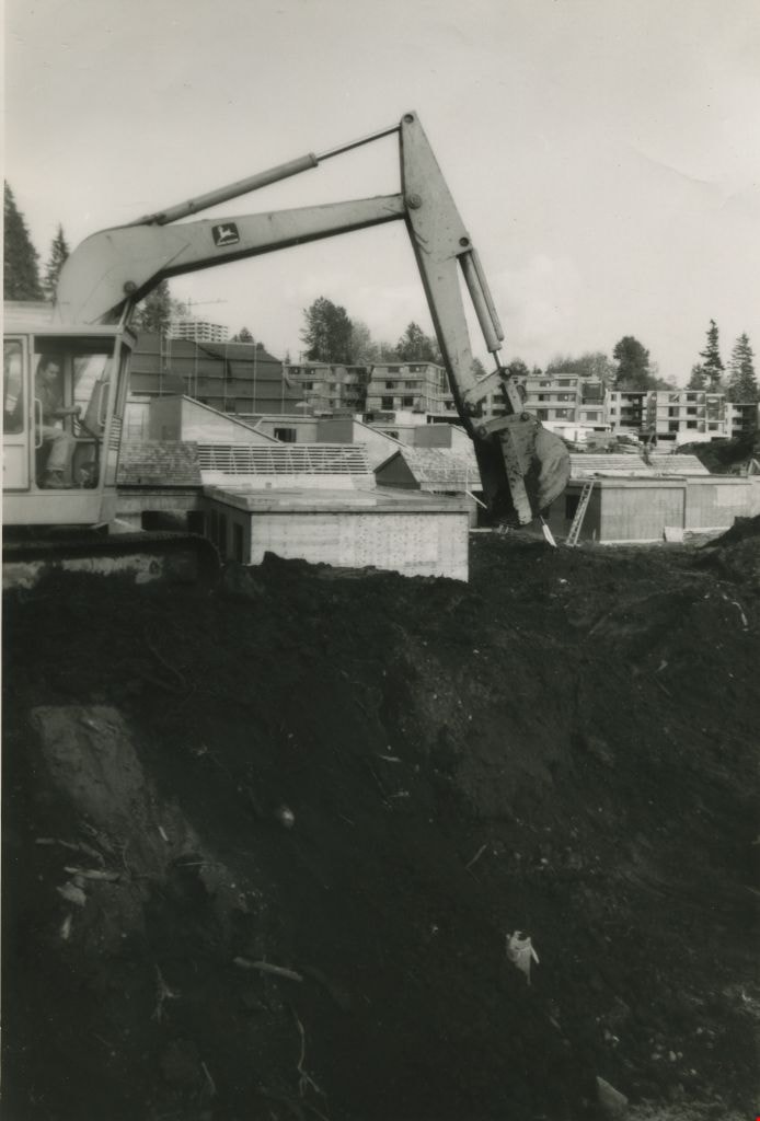
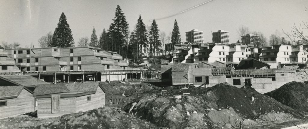
Construction of MacInnis Place
https://search.heritageburnaby.ca/link/archivedescription45408
- Repository
- City of Burnaby Archives
- Date
- March 1976
- Collection/Fonds
- Columbian Newspaper collection
- Description Level
- Item
- Physical Description
- 1 photograph : b&w ; 10 x 24.5 cm
- Scope and Content
- Photograph of the construction of MacInnis Place in Burnaby. This housing development was constructed with the intent of having 25% of its suites rented at a reduced cost to low income earners.
- Repository
- City of Burnaby Archives
- Date
- March 1976
- Collection/Fonds
- Columbian Newspaper collection
- Physical Description
- 1 photograph : b&w ; 10 x 24.5 cm
- Description Level
- Item
- Record No.
- 480-303
- Access Restriction
- No restrictions
- Reproduction Restriction
- No restrictions
- Accession Number
- 2003-02
- Scope and Content
- Photograph of the construction of MacInnis Place in Burnaby. This housing development was constructed with the intent of having 25% of its suites rented at a reduced cost to low income earners.
- Names
- MacInnis Place
- Media Type
- Photograph
- Photographer
- King, Basil
- Notes
- Title based on contents of photograph
- Geographic Access
- Keswick Avenue
- Historic Neighbourhood
- Burquitlam (Historic Neighbourhood)
- Planning Study Area
- Cameron Area
Images

Construction of MacInnis Place
https://search.heritageburnaby.ca/link/archivedescription45409
- Repository
- City of Burnaby Archives
- Date
- March 1976
- Collection/Fonds
- Columbian Newspaper collection
- Description Level
- Item
- Physical Description
- 1 photograph : b&w ; 11.5 x 24.5 cm
- Scope and Content
- Photograph of the construction of MacInnis Place in Burnaby. This housing development was constructed with the intent of having 25% of its suites rented at a reduced cost to low income earners.
- Repository
- City of Burnaby Archives
- Date
- March 1976
- Collection/Fonds
- Columbian Newspaper collection
- Physical Description
- 1 photograph : b&w ; 11.5 x 24.5 cm
- Description Level
- Item
- Record No.
- 480-304
- Access Restriction
- No restrictions
- Reproduction Restriction
- No restrictions
- Accession Number
- 2003-02
- Scope and Content
- Photograph of the construction of MacInnis Place in Burnaby. This housing development was constructed with the intent of having 25% of its suites rented at a reduced cost to low income earners.
- Names
- MacInnis Place
- Media Type
- Photograph
- Photographer
- King, Basil
- Notes
- Title based on contents of photograph
- Geographic Access
- Keswick Avenue
- Historic Neighbourhood
- Burquitlam (Historic Neighbourhood)
- Planning Study Area
- Cameron Area
Images


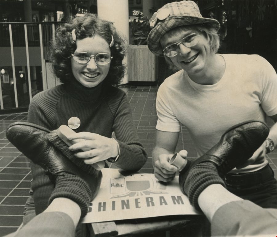
Cystic Fibrosis fundraiser
https://search.heritageburnaby.ca/link/archivedescription45447
- Repository
- City of Burnaby Archives
- Date
- September 1973
- Collection/Fonds
- Columbian Newspaper collection
- Description Level
- Item
- Physical Description
- 1 photograph : b&w ; 16.5 x 19.5 cm
- Scope and Content
- Photograph of Columbian photographer Basil King getting his shoes shined by British Columbia Institute of Technology students Kathy McLeod and Russ Carmichael at Lougheed mall (now Lougheed Town Centre). This was part of the Cystic Fibrosis fundraiser known as Shinerama.
- Repository
- City of Burnaby Archives
- Date
- September 1973
- Collection/Fonds
- Columbian Newspaper collection
- Physical Description
- 1 photograph : b&w ; 16.5 x 19.5 cm
- Description Level
- Item
- Record No.
- 480-342
- Access Restriction
- No restrictions
- Reproduction Restriction
- No restrictions
- Accession Number
- 2003-02
- Scope and Content
- Photograph of Columbian photographer Basil King getting his shoes shined by British Columbia Institute of Technology students Kathy McLeod and Russ Carmichael at Lougheed mall (now Lougheed Town Centre). This was part of the Cystic Fibrosis fundraiser known as Shinerama.
- Names
- British Columbia Institute of Technology
- Lougheed Town Centre
- King, Basil
- McLeod, Kathy
- Carmichael, Russ
- Media Type
- Photograph
- Photographer
- King, Basil
- Notes
- Title based on contents of photograph
- Newspaper clipping attached to verso of photograph reads: "The shoes in need of a shine are Columbian photographer Basil King's. The cheerful shiners at Lougheed mall today are Kathy McLeod and Russ Carmichael. The occasion: Shinerama '73. Hundreds of B.C. Institute of Technology students are on the job at Lower Mainland shopping centres, raising funds for cystic fibrosis research."
- Geographic Access
- North Road
- Austin Road
- Historic Neighbourhood
- Burquitlam (Historic Neighbourhood)
- Planning Study Area
- Cameron Area
Images
Aerial photograph of Burnaby and Coquitlam
https://search.heritageburnaby.ca/link/archivedescription84912
- Repository
- City of Burnaby Archives
- Date
- 1963
- Collection/Fonds
- Allan Amundsen collection
- Description Level
- Item
- Physical Description
- 1 photograph : b&w ; 22.5 x 22.5 cm
- Scope and Content
- Aerial photograph of Burnaby and Coquitlam with North Road running through the centre.
- Repository
- City of Burnaby Archives
- Date
- 1963
- Collection/Fonds
- Allan Amundsen collection
- Physical Description
- 1 photograph : b&w ; 22.5 x 22.5 cm
- Description Level
- Item
- Record No.
- 561-030
- Access Restriction
- In Archives only
- Reproduction Restriction
- No reproduction permitted
- Accession Number
- 2014-08
- Scope and Content
- Aerial photograph of Burnaby and Coquitlam with North Road running through the centre.
- Subjects
- Aerial Photographs
- Media Type
- Photograph
- Photographer
- Province of British Columbia
- Notes
- Title based on contents of photograph
- This photo is indentified as BC5062:21 and connects with B.C. air photograph BC5062:22 to the west and BC5062:70 to the east
- Historic Neighbourhood
- Burquitlam (Historic Neighbourhood)
- Planning Study Area
- Cameron Area
- Lyndhurst Area
- Cariboo-Armstrong Area
Aerial photograph of Burnaby
https://search.heritageburnaby.ca/link/archivedescription84913
- Repository
- City of Burnaby Archives
- Date
- 1963
- Collection/Fonds
- Allan Amundsen collection
- Description Level
- Item
- Physical Description
- 1 photograph : b&w ; 22.5 x 22.5 cm
- Scope and Content
- Aerial photograph of East Burnaby up to North Road and south of the Trans Canada Highway.
- Repository
- City of Burnaby Archives
- Date
- 1963
- Collection/Fonds
- Allan Amundsen collection
- Physical Description
- 1 photograph : b&w ; 22.5 x 22.5 cm
- Description Level
- Item
- Record No.
- 561-031
- Access Restriction
- In Archives only
- Reproduction Restriction
- No reproduction permitted
- Accession Number
- 2014-08
- Scope and Content
- Aerial photograph of East Burnaby up to North Road and south of the Trans Canada Highway.
- Subjects
- Aerial Photographs
- Media Type
- Photograph
- Photographer
- Province of British Columbia
- Notes
- Title based on contents of photograph
- This photo is indentified as BC5062:70 and connects with B.C. air photograph BC5062:21 to the west and BC5062:71 to the east
- Historic Neighbourhood
- East Burnaby (Historic Neighbourhood)
- Planning Study Area
- Cameron Area
- Cariboo-Armstrong Area