Narrow Results By
Subject
- Accidents 10
- Accidents - Automobile Accidents 26
- Accidents - Train Accidents 8
- Adornment - Jewelry 3
- Adornment - Lapel Pins 1
- Advertising Medium 10
- Advertising Medium - Signs and Signboards
- Aerial Photographs 88
- Agricultural Tools and Equipment 16
- Agricultural Tools and Equipment - Cultivators 1
- Agricultural Tools and Equipment - Gardening Equipment
- Agricultural Tools and Equipment - Plows 9
Person / Organization
- A & Aero Trading Salvage 1
- Admiral Hotel 2
- A. MacKenzie and Company Jubilee Store 3
- Anthony, Bill 1
- Astor Hotel 3
- Blue Mountain Flower and Garden Shop 1
- Bonsor Recreation Complex 1
- Bowker, A.D. 1
- British Columbia Hydro and Power Authority 2
- Burnaby Art Gallery 1
- Burnaby Chamber of Commerce 1
- Burnaby Christian Supply 1
![Blythe Eagles in the garden, [1930] (date of original), copied 1996 thumbnail](/media/hpo/_Data/_Archives_Images/_Unrestricted/316/331-001.jpg?width=280)
Blythe Eagles in the garden
https://search.heritageburnaby.ca/link/archivedescription37183
- Repository
- City of Burnaby Archives
- Date
- [1930] (date of original), copied 1996
- Collection/Fonds
- Burnaby Historical Society fonds
- Description Level
- Item
- Physical Description
- 1 photograph : b&w ; 16.5 x 10 cm print
- Scope and Content
- Photograph of Blythe Eagles with his shirt off, working in the garden.
- Repository
- City of Burnaby Archives
- Date
- [1930] (date of original), copied 1996
- Collection/Fonds
- Burnaby Historical Society fonds
- Subseries
- Eagles family subseries
- Physical Description
- 1 photograph : b&w ; 16.5 x 10 cm print
- Description Level
- Item
- Record No.
- 331-001
- Access Restriction
- No restrictions
- Reproduction Restriction
- No known restrictions
- Accession Number
- BHS1996-21
- Scope and Content
- Photograph of Blythe Eagles with his shirt off, working in the garden.
- Names
- Eagles, Dr. Blythe
- Media Type
- Photograph
- Notes
- Title based on contents of photograph
- Geographic Access
- Sperling Avenue
- Street Address
- 5655 Sperling Avenue
- Historic Neighbourhood
- Burnaby Lake (Historic Neighbourhood)
- Planning Study Area
- Morley-Buckingham Area
Images
![Blythe Eagles in the garden, [1930] (date of original), copied 1996 thumbnail](/media/hpo/_Data/_Archives_Images/_Unrestricted/316/331-001.jpg)
![Patterson family, 1912 (date of original), copied [1997] thumbnail](/media/hpo/_Data/_Archives_Images/_Unrestricted/316/350-010.jpg?width=280)
Patterson family
https://search.heritageburnaby.ca/link/archivedescription37316
- Repository
- City of Burnaby Archives
- Date
- 1912 (date of original), copied [1997]
- Collection/Fonds
- Burnaby Historical Society fonds
- Description Level
- Item
- Physical Description
- 1 photograph : b&w ; 9 x 12 cm print
- Scope and Content
- Photograph of eight members of the D.C. Patterson, standing in the garden outside the family home in the Edmonds district. The house was originally located at 7260 Edmonds Street (near Kingsway). It was relocated in 1955 to 7106 18th Avenue and is a city heritage site.
- Repository
- City of Burnaby Archives
- Date
- 1912 (date of original), copied [1997]
- Collection/Fonds
- Burnaby Historical Society fonds
- Subseries
- Jim Wolf subseries
- Physical Description
- 1 photograph : b&w ; 9 x 12 cm print
- Description Level
- Item
- Record No.
- 350-010
- Access Restriction
- No restrictions
- Reproduction Restriction
- No known restrictions
- Accession Number
- BHS1997-09
- Scope and Content
- Photograph of eight members of the D.C. Patterson, standing in the garden outside the family home in the Edmonds district. The house was originally located at 7260 Edmonds Street (near Kingsway). It was relocated in 1955 to 7106 18th Avenue and is a city heritage site.
- Media Type
- Photograph
- Notes
- Title based on contents of photograph.
- Geographic Access
- Edmonds Street
- 18th Avenue
- Street Address
- 7260 Edmonds Street
- 7106 18th Avenue
- Historic Neighbourhood
- Edmonds (Historic Neighbourhood)
- Planning Study Area
- Stride Avenue Area
Images
![Patterson family, 1912 (date of original), copied [1997] thumbnail](/media/hpo/_Data/_Archives_Images/_Unrestricted/316/350-010.jpg)
![3951 and 3953 Hastings Street, [1965] thumbnail](/media/hpo/_Data/_Archives_Images/_Unrestricted/316/366-014.jpg?width=280)
3951 and 3953 Hastings Street
https://search.heritageburnaby.ca/link/archivedescription37385
- Repository
- City of Burnaby Archives
- Date
- [1965]
- Collection/Fonds
- Burnaby Historical Society fonds
- Description Level
- Item
- Physical Description
- 1 photograph : b&w negative
- Scope and Content
- Photograph of the buildings at 3951 and 3953 Hastings Street. A number of business signs are visible including "Paulettes Beauty Salon" and "Norburn Secondhand Store."
- Repository
- City of Burnaby Archives
- Date
- [1965]
- Collection/Fonds
- Burnaby Historical Society fonds
- Subseries
- Municipal record subseries
- Physical Description
- 1 photograph : b&w negative
- Description Level
- Item
- Record No.
- 366-014
- Access Restriction
- No restrictions
- Reproduction Restriction
- Reproduce for fair dealing purposes only
- Accession Number
- BHS1998-12
- Scope and Content
- Photograph of the buildings at 3951 and 3953 Hastings Street. A number of business signs are visible including "Paulettes Beauty Salon" and "Norburn Secondhand Store."
- Media Type
- Photograph
- Notes
- Title based on contents of photograph
- Geographic Access
- Hastings Street
- Street Address
- 3953 Hastings Street
- 3951 Hastings Street
- Historic Neighbourhood
- Vancouver Heights (Historic Neighbourhood)
- Planning Study Area
- Burnaby Heights Area
Images
![3951 and 3953 Hastings Street, [1965] thumbnail](/media/hpo/_Data/_Archives_Images/_Unrestricted/316/366-014.jpg)

Burnaby Mountain Park and Centennial Pavilion
https://search.heritageburnaby.ca/link/archivedescription37408
- Repository
- City of Burnaby Archives
- Date
- 1970
- Collection/Fonds
- Burnaby Historical Society fonds
- Description Level
- Item
- Physical Description
- 1 photograph : col. postcard ; 9 x 14 cm
- Scope and Content
- Photographic postcard of the Burnaby Mountain Park sign a Centennial Pavilion. The caption on the back of the postcard reads: "The Centennial Pavilion was built in 1958 during British Columbia's Centenary. It is situated on Burnaby Mountain at an elevation of 1000 feet. Numerous footpaths througho…
- Repository
- City of Burnaby Archives
- Date
- 1970
- Collection/Fonds
- Burnaby Historical Society fonds
- Subseries
- Robert Prittie subseries
- Physical Description
- 1 photograph : col. postcard ; 9 x 14 cm
- Description Level
- Item
- Record No.
- 369-007
- Access Restriction
- No restrictions
- Reproduction Restriction
- Reproduce for fair dealing purposes only
- Accession Number
- BHS1999-01
- Scope and Content
- Photographic postcard of the Burnaby Mountain Park sign a Centennial Pavilion. The caption on the back of the postcard reads: "The Centennial Pavilion was built in 1958 during British Columbia's Centenary. It is situated on Burnaby Mountain at an elevation of 1000 feet. Numerous footpaths throughout the beautifully landscaped grounds lead to interesting view points which provide magnificent scenery of Burrard Inlet, Coast Range Mountains, City of Vancouver, and other surrounding Municipalities."
- Subjects
- Symbols - Flags
- Documentary Artifacts - Postcards
- Buildings - Recreational
- Advertising Medium - Signs and Signboards
- Media Type
- Photograph
- Photographer
- George Allen Aerial Photos Limited
- Notes
- Title based on caption
- Geographic Access
- Burnaby Mountain Conservation Area
- Centennial Way
- Street Address
- 100 Centennial Way
- Planning Study Area
- Burnaby Mountain Area
Images


Deer Lake
https://search.heritageburnaby.ca/link/archivedescription91707
- Repository
- City of Burnaby Archives
- Date
- 1994-1996
- Collection/Fonds
- Doreen Lawson fonds
- Description Level
- File
- Physical Description
- 55 photographs : col. slides ; 35 mm
- Scope and Content
- File consists of scenic photographs of Deer Lake and Deer Lake Park, including closeup photographs of the lake and landscape photographs with the lake in the foreground and mountains and skyline visible in the distance. The photographs capture Deer Lake in the fall, winter, and spring. Also inclu…
- Repository
- City of Burnaby Archives
- Date
- 1994-1996
- Collection/Fonds
- Doreen Lawson fonds
- Physical Description
- 55 photographs : col. slides ; 35 mm
- Description Level
- File
- Record No.
- 618-025
- Access Restriction
- No restrictions
- Reproduction Restriction
- No restrictions
- Accession Number
- 2015-15
- Scope and Content
- File consists of scenic photographs of Deer Lake and Deer Lake Park, including closeup photographs of the lake and landscape photographs with the lake in the foreground and mountains and skyline visible in the distance. The photographs capture Deer Lake in the fall, winter, and spring. Also included in the file are four photographs of Deer Lake Park signs.
- Subjects
- Natural Phenomena - Snow
- Geographic Features - Lakes and Ponds
- Plants - Trees
- Geographic Features - Mountains
- Advertising Medium - Signs and Signboards
- Names
- Burnaby Art Gallery
- Media Type
- Photograph
- Photographer
- Lawson, Doreen A.
- Notes
- Title based on contents of photographs
- Geographic Access
- Deer Lake
- Historic Neighbourhood
- Burnaby Lake (Historic Neighbourhood)
- Planning Study Area
- Oakalla Area
Images

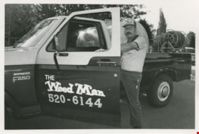
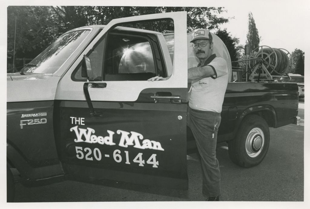
"The Weed Man"
https://search.heritageburnaby.ca/link/archivedescription58936
- Repository
- City of Burnaby Archives
- Date
- ca.1983
- Collection/Fonds
- Columbian Newspaper collection
- Description Level
- Item
- Physical Description
- 1 photograph : b&w ; 14 x 20.5 cm
- Scope and Content
- Photograph of a man posing with his pick-up truck containing lawn and landscaping equipment. His truck, hat, and shirt all read "The Weed Man."
- Repository
- City of Burnaby Archives
- Date
- ca.1983
- Collection/Fonds
- Columbian Newspaper collection
- Physical Description
- 1 photograph : b&w ; 14 x 20.5 cm
- Description Level
- Item
- Record No.
- 480-1385
- Access Restriction
- No restrictions
- Reproduction Restriction
- Reproduce for fair dealing purposes only
- Accession Number
- 2009-01
- Scope and Content
- Photograph of a man posing with his pick-up truck containing lawn and landscaping equipment. His truck, hat, and shirt all read "The Weed Man."
- Subjects
- Agricultural Tools and Equipment - Gardening Equipment
- Maintenance Tools and Equipment
- Occupations
- Transportation - Trucks
- Media Type
- Photograph
- Photographer
- Hodge, Craig
- Notes
- Title based on contents of photograph
- Photographer's stamp on verso
- Note on verso reads: "Burnaby Today / A-8 / 47% PMT"
Images
![Opening of the Knight and Day Restaurant at Boundary and Lougheed Highway, [1982] thumbnail](/media/Hpo/_Data/_Archives_Images/_Unrestricted/480/480-1530.jpg?width=280)
Opening of the Knight and Day Restaurant at Boundary and Lougheed Highway
https://search.heritageburnaby.ca/link/archivedescription59215
- Repository
- City of Burnaby Archives
- Date
- [1982]
- Collection/Fonds
- Columbian Newspaper collection
- Description Level
- Item
- Physical Description
- 1 photograph : b&w ; 8.5 x 18.5 cm
- Scope and Content
- Photograph of a sign advertising the new location of Knight & Day Restaurant opening in December. There is a long line of people lining up next to the restaurant in the background.
- Repository
- City of Burnaby Archives
- Date
- [1982]
- Collection/Fonds
- Columbian Newspaper collection
- Physical Description
- 1 photograph : b&w ; 8.5 x 18.5 cm
- Description Level
- Item
- Record No.
- 480-1530
- Access Restriction
- No restrictions
- Reproduction Restriction
- No restrictions
- Accession Number
- 2009-01
- Scope and Content
- Photograph of a sign advertising the new location of Knight & Day Restaurant opening in December. There is a long line of people lining up next to the restaurant in the background.
- Media Type
- Photograph
- Photographer
- King, Basil
- Notes
- Title based on contents of photograph
- Photographer's stamp on verso
- Note on verso reads: "PMT 100% / page 1 / Burnaby Today"
- Geographic Access
- Lougheed Highway
- Boundary Road
Images
![Opening of the Knight and Day Restaurant at Boundary and Lougheed Highway, [1982] thumbnail](/media/Hpo/_Data/_Archives_Images/_Unrestricted/480/480-1530.jpg)

Exterior of 1665 Sherlock Avenue
https://search.heritageburnaby.ca/link/archivedescription78949
- Repository
- City of Burnaby Archives
- Date
- October 12,1976
- Collection/Fonds
- Burnaby Public Library Contemporary Visual Archive Project
- Description Level
- Item
- Physical Description
- 1 photograph : b&w ; 11 x 16 cm mounted on cardboard
- Scope and Content
- Photograph shows the homemade sign and garden ornament at 1665 Sherlock Avenue.
- Repository
- City of Burnaby Archives
- Date
- October 12,1976
- Collection/Fonds
- Burnaby Public Library Contemporary Visual Archive Project
- Physical Description
- 1 photograph : b&w ; 11 x 16 cm mounted on cardboard
- Description Level
- Item
- Record No.
- 556-044
- Access Restriction
- No restrictions
- Reproduction Restriction
- Reproduce for fair dealing purposes only
- Accession Number
- 2013-13
- Scope and Content
- Photograph shows the homemade sign and garden ornament at 1665 Sherlock Avenue.
- Media Type
- Photograph
- Photographer
- Born, A. J.
- Notes
- Scope note taken directly from BPL photograph description.
- 1 b&w copy negative : 10 x 12.5 cm accompanying
- Geographic Access
- Sherlock Avenue
- Street Address
- 1665 Sherlock Avenue
- Historic Neighbourhood
- Lochdale (Historic Neighbourhood)
- Planning Study Area
- Lochdale Area
Images


Quesnel Greene Construction
https://search.heritageburnaby.ca/link/archivedescription79014
- Repository
- City of Burnaby Archives
- Date
- October 23, 1976
- Collection/Fonds
- Burnaby Public Library Contemporary Visual Archive Project
- Description Level
- Item
- Physical Description
- 1 photograph : b&w ; 11 x 16 cm mounted on cardboard
- Scope and Content
- Photograph shows Quesnel Greene construction sign located at the corner of Aquarius Drive and Centaurus Circle. The Quesnel Green Co-operative Housing project was designed by Neinhaker/Irwin Associates and was built by Dunhill Development Corporation Ltd. It was owned by the Government of British…
- Repository
- City of Burnaby Archives
- Date
- October 23, 1976
- Collection/Fonds
- Burnaby Public Library Contemporary Visual Archive Project
- Physical Description
- 1 photograph : b&w ; 11 x 16 cm mounted on cardboard
- Description Level
- Item
- Record No.
- 556-091
- Access Restriction
- No restrictions
- Reproduction Restriction
- Reproduce for fair dealing purposes only
- Accession Number
- 2013-13
- Scope and Content
- Photograph shows Quesnel Greene construction sign located at the corner of Aquarius Drive and Centaurus Circle. The Quesnel Green Co-operative Housing project was designed by Neinhaker/Irwin Associates and was built by Dunhill Development Corporation Ltd. It was owned by the Government of British Columbia.
- Media Type
- Photograph
- Photographer
- Campbell, Peg
- Notes
- Scope note taken directly from BPL photograph description.
- 1 b&w copy negative : 10 x 12.5 cm accompanying
- Geographic Access
- Centaurus Circle
- Aquarius Drive
- Historic Neighbourhood
- Burquitlam (Historic Neighbourhood)
- Planning Study Area
- Lyndhurst Area
Images


Apartment at Albert and Ingleton
https://search.heritageburnaby.ca/link/archivedescription79031
- Repository
- City of Burnaby Archives
- Date
- September 12, 1976
- Collection/Fonds
- Burnaby Public Library Contemporary Visual Archive Project
- Description Level
- Item
- Physical Description
- 1 photograph : b&w ; 11 x 16 cm mounted on cardboard
- Scope and Content
- Photograph shows a sign on an apartment building on Albert Street near Ingleton Avenue.
- Repository
- City of Burnaby Archives
- Date
- September 12, 1976
- Collection/Fonds
- Burnaby Public Library Contemporary Visual Archive Project
- Physical Description
- 1 photograph : b&w ; 11 x 16 cm mounted on cardboard
- Description Level
- Item
- Record No.
- 556-102
- Access Restriction
- No restrictions
- Reproduction Restriction
- Reproduce for fair dealing purposes only
- Accession Number
- 2013-13
- Scope and Content
- Photograph shows a sign on an apartment building on Albert Street near Ingleton Avenue.
- Media Type
- Photograph
- Notes
- Scope note taken directly from BPL photograph description.
- 1 b&w copy negative : 10 x 12.5 cm accompanying
- Photographers identified by surnames only: Carr and Vardeman
- Geographic Access
- Albert Street
- Ingleton Avenue
- Historic Neighbourhood
- Vancouver Heights (Historic Neighbourhood)
- Planning Study Area
- Burnaby Heights Area
Images


Signs at the Willingdon Heights Community Church
https://search.heritageburnaby.ca/link/archivedescription79050
- Repository
- City of Burnaby Archives
- Date
- October, 1976
- Collection/Fonds
- Burnaby Public Library Contemporary Visual Archive Project
- Description Level
- Item
- Physical Description
- 1 photograph : b&w ; 11 x 16 cm mounted on cardboard
- Scope and Content
- Photograph shows signs at the Willingdon Heights Community Church, advertising activities at the Church.
- Repository
- City of Burnaby Archives
- Date
- October, 1976
- Collection/Fonds
- Burnaby Public Library Contemporary Visual Archive Project
- Physical Description
- 1 photograph : b&w ; 11 x 16 cm mounted on cardboard
- Description Level
- Item
- Record No.
- 556-117
- Access Restriction
- No restrictions
- Reproduction Restriction
- Reproduce for fair dealing purposes only
- Accession Number
- 2013-13
- Scope and Content
- Photograph shows signs at the Willingdon Heights Community Church, advertising activities at the Church.
- Media Type
- Photograph
- Photographer
- Cook, Alan
- Notes
- Scope note taken directly from BPL photograph description.
- 1 b&w copy negative : 10 x 12.5 cm accompanying
- Geographic Access
- Parker Street
- Street Address
- 4304 Parker Street
- Historic Neighbourhood
- Vancouver Heights (Historic Neighbourhood)
- Planning Study Area
- Willingdon Heights Area
Images


Advertising adjacent Jan's Grocery Store
https://search.heritageburnaby.ca/link/archivedescription79082
- Repository
- City of Burnaby Archives
- Date
- October, 1976
- Collection/Fonds
- Burnaby Public Library Contemporary Visual Archive Project
- Description Level
- Item
- Physical Description
- 1 photograph : b&w ; 11 x 16 cm mounted on cardboard
- Scope and Content
- Photograph shows large billboard advertising the PNE, beside Jan's Grocery store located at 4759 Hastings Street.
- Repository
- City of Burnaby Archives
- Date
- October, 1976
- Collection/Fonds
- Burnaby Public Library Contemporary Visual Archive Project
- Physical Description
- 1 photograph : b&w ; 11 x 16 cm mounted on cardboard
- Description Level
- Item
- Record No.
- 556-141
- Access Restriction
- No restrictions
- Reproduction Restriction
- Reproduce for fair dealing purposes only
- Accession Number
- 2013-13
- Scope and Content
- Photograph shows large billboard advertising the PNE, beside Jan's Grocery store located at 4759 Hastings Street.
- Media Type
- Photograph
- Photographer
- Cook, Alan
- Notes
- Scope note taken directly from BPL photograph description.
- 1 b&w copy negative : 10 x 12.5 cm accompanying
- Geographic Access
- Hastings Street
- Street Address
- 4759 Hastings Street
- Historic Neighbourhood
- Capitol Hill (Historic Neighbourhood)
- Planning Study Area
- Capitol Hill Area
Images


Royal Oak Grocery
https://search.heritageburnaby.ca/link/archivedescription79092
- Repository
- City of Burnaby Archives
- Date
- September 13, 1976
- Collection/Fonds
- Burnaby Public Library Contemporary Visual Archive Project
- Description Level
- Item
- Physical Description
- 1 photograph : b&w ; 11 x 16 cm mounted on cardboard
- Scope and Content
- Photograph shows Royal Oak Grocery located at 6537 Royal Oak Avenue. The store was built in approximately 1946 and has living quarters above.
- Repository
- City of Burnaby Archives
- Date
- September 13, 1976
- Collection/Fonds
- Burnaby Public Library Contemporary Visual Archive Project
- Physical Description
- 1 photograph : b&w ; 11 x 16 cm mounted on cardboard
- Description Level
- Item
- Record No.
- 556-146
- Access Restriction
- No restrictions
- Reproduction Restriction
- Reproduce for fair dealing purposes only
- Accession Number
- 2013-13
- Scope and Content
- Photograph shows Royal Oak Grocery located at 6537 Royal Oak Avenue. The store was built in approximately 1946 and has living quarters above.
- Names
- Royal Oak Grocery
- Media Type
- Photograph
- Photographer
- McCarron, John
- Notes
- Scope note taken directly from BPL photograph description.
- 1 b&w copy negative : 10 x 12.5 cm accompanying
- Geographic Access
- Royal Oak Avenue
- Street Address
- 6537 Royal Oak Avenue
- Historic Neighbourhood
- Central Park (Historic Neighbourhood)
- Planning Study Area
- Marlborough Area
Images


G & L Store
https://search.heritageburnaby.ca/link/archivedescription79113
- Repository
- City of Burnaby Archives
- Date
- September 20, 1976
- Collection/Fonds
- Burnaby Public Library Contemporary Visual Archive Project
- Description Level
- Item
- Physical Description
- 1 photograph : b&w ; 11 x 16 cm mounted on cardboard
- Scope and Content
- Photograph shows numerous signs on the wall of the G & L Store built around 1945 on MacPherson Avenue near Beresford Street.
- Repository
- City of Burnaby Archives
- Date
- September 20, 1976
- Collection/Fonds
- Burnaby Public Library Contemporary Visual Archive Project
- Physical Description
- 1 photograph : b&w ; 11 x 16 cm mounted on cardboard
- Description Level
- Item
- Record No.
- 556-161
- Access Restriction
- No restrictions
- Reproduction Restriction
- Reproduce for fair dealing purposes only
- Accession Number
- 2013-13
- Scope and Content
- Photograph shows numerous signs on the wall of the G & L Store built around 1945 on MacPherson Avenue near Beresford Street.
- Media Type
- Photograph
- Photographer
- McCarron, John
- Notes
- Scope note taken directly from BPL photograph description.
- 1 b&w copy negative : 10 x 12.5 cm accompanying
- Geographic Access
- MacPherson Avenue
- Beresford Street
- Planning Study Area
- Windsor Area
Images


Advertising Signs
https://search.heritageburnaby.ca/link/archivedescription79154
- Repository
- City of Burnaby Archives
- Date
- November 1, 1976
- Collection/Fonds
- Burnaby Public Library Contemporary Visual Archive Project
- Description Level
- Item
- Physical Description
- 1 photograph : b&w ; 11 x 16 cm mounted on cardboard
- Scope and Content
- Photograph shows signs advertising Musgrove Ford Ltd. and Burnaby Cleaners on top of the building which housed Burnaby Cleaners at 4429 Hastings Street.
- Repository
- City of Burnaby Archives
- Date
- November 1, 1976
- Collection/Fonds
- Burnaby Public Library Contemporary Visual Archive Project
- Physical Description
- 1 photograph : b&w ; 11 x 16 cm mounted on cardboard
- Description Level
- Item
- Record No.
- 556-178
- Access Restriction
- No restrictions
- Reproduction Restriction
- Reproduce for fair dealing purposes only
- Accession Number
- 2013-13
- Scope and Content
- Photograph shows signs advertising Musgrove Ford Ltd. and Burnaby Cleaners on top of the building which housed Burnaby Cleaners at 4429 Hastings Street.
- Names
- Burnaby Cleaners
- Media Type
- Photograph
- Notes
- Scope note taken directly from BPL photograph description.
- 1 b&w copy negative : 10 x 12.5 cm accompanying
- Photographers identified by surnames only: Carr and Vardeman
- Geographic Access
- Hastings Street
- Street Address
- 4429 Hastings Street
- Historic Neighbourhood
- Vancouver Heights (Historic Neighbourhood)
- Planning Study Area
- Burnaby Heights Area
Images


Billboards at Hastings and Boundary
https://search.heritageburnaby.ca/link/archivedescription79163
- Repository
- City of Burnaby Archives
- Date
- November 1, 1976
- Collection/Fonds
- Burnaby Public Library Contemporary Visual Archive Project
- Description Level
- Item
- Physical Description
- 1 photograph : b&w ; 11 x 16 cm mounted on cardboard
- Scope and Content
- Photograph shows men working on billboards above Moffat's Furniture at the corner of Hastings Street and Boundary Road.
- Repository
- City of Burnaby Archives
- Date
- November 1, 1976
- Collection/Fonds
- Burnaby Public Library Contemporary Visual Archive Project
- Physical Description
- 1 photograph : b&w ; 11 x 16 cm mounted on cardboard
- Description Level
- Item
- Record No.
- 556-182
- Access Restriction
- No restrictions
- Reproduction Restriction
- Reproduce for fair dealing purposes only
- Accession Number
- 2013-13
- Scope and Content
- Photograph shows men working on billboards above Moffat's Furniture at the corner of Hastings Street and Boundary Road.
- Names
- Moffat's Furniture
- Media Type
- Photograph
- Notes
- Scope note taken directly from BPL photograph description.
- 1 b&w copy negative : 10 x 12.5 cm accompanying
- Photographers identified by surnames only: Carr and Vardeman
- Geographic Access
- Hastings Street
- Boundary Road
- Historic Neighbourhood
- Vancouver Heights (Historic Neighbourhood)
- Planning Study Area
- Willingdon Heights Area
Images


A & Aero Trading Salvage
https://search.heritageburnaby.ca/link/archivedescription79166
- Repository
- City of Burnaby Archives
- Date
- October 16, 1976
- Collection/Fonds
- Burnaby Public Library Contemporary Visual Archive Project
- Description Level
- Item
- Physical Description
- 1 photograph : b&w ; 11 x 16 cm mounted on cardboard
- Scope and Content
- Photograph shows a large sign advertising lawn mower sharpening over A & Aero Trading Salvage at 6147 Hastings Street.
- Repository
- City of Burnaby Archives
- Date
- October 16, 1976
- Collection/Fonds
- Burnaby Public Library Contemporary Visual Archive Project
- Physical Description
- 1 photograph : b&w ; 11 x 16 cm mounted on cardboard
- Description Level
- Item
- Record No.
- 556-184
- Access Restriction
- No restrictions
- Reproduction Restriction
- Reproduce for fair dealing purposes only
- Accession Number
- 2013-13
- Scope and Content
- Photograph shows a large sign advertising lawn mower sharpening over A & Aero Trading Salvage at 6147 Hastings Street.
- Names
- A & Aero Trading Salvage
- Media Type
- Photograph
- Notes
- Scope note taken directly from BPL photograph description.
- 1 b&w copy negative : 10 x 12.5 cm accompanying
- Photographers identified by surnames only: Carr and Vardeman
- Geographic Access
- Hastings Street
- Street Address
- 6147 Hastings Street
- Historic Neighbourhood
- Lochdale (Historic Neighbourhood)
- Planning Study Area
- Westridge Area
Images


Kiddies' World
https://search.heritageburnaby.ca/link/archivedescription79170
- Repository
- City of Burnaby Archives
- Date
- September 20, 1976
- Collection/Fonds
- Burnaby Public Library Contemporary Visual Archive Project
- Description Level
- Item
- Physical Description
- 1 photograph : b&w ; 11 x 16 cm mounted on cardboard
- Scope and Content
- Photograph shows Kiddies' World Store at 9607 Lougheed Highway.
- Repository
- City of Burnaby Archives
- Date
- September 20, 1976
- Collection/Fonds
- Burnaby Public Library Contemporary Visual Archive Project
- Physical Description
- 1 photograph : b&w ; 11 x 16 cm mounted on cardboard
- Description Level
- Item
- Record No.
- 556-187
- Access Restriction
- No restrictions
- Reproduction Restriction
- Reproduce for fair dealing purposes only
- Accession Number
- 2013-13
- Scope and Content
- Photograph shows Kiddies' World Store at 9607 Lougheed Highway.
- Names
- Kiddies' World
- Media Type
- Photograph
- Photographer
- Campbell, Peg
- Notes
- Scope note taken directly from BPL photograph description.
- 1 b&w copy negative : 10 x 12.5 cm accompanying
- Geographic Access
- Lougheed Highway
- Street Address
- 9607 Lougheed Highway
- Historic Neighbourhood
- Burquitlam (Historic Neighbourhood)
- Planning Study Area
- Cameron Area
Images


McKay Barbers
https://search.heritageburnaby.ca/link/archivedescription79177
- Repository
- City of Burnaby Archives
- Date
- September 15, 1976
- Collection/Fonds
- Burnaby Public Library Contemporary Visual Archive Project
- Description Level
- Item
- Physical Description
- 1 photograph : b&w ; 11 x 16 cm mounted on cardboard
- Scope and Content
- Photograph shows signs in the window of McKay Barbers advertising prices for haircuts. The shop, on Kingsway near McKay, was built in the 1920s originally as part of the grocery store next door and was a bakery for a time. At the time of the photograph, it had been a barber shop for 42 years.
- Repository
- City of Burnaby Archives
- Date
- September 15, 1976
- Collection/Fonds
- Burnaby Public Library Contemporary Visual Archive Project
- Physical Description
- 1 photograph : b&w ; 11 x 16 cm mounted on cardboard
- Description Level
- Item
- Record No.
- 556-191
- Access Restriction
- No restrictions
- Reproduction Restriction
- Reproduce for fair dealing purposes only
- Accession Number
- 2013-13
- Scope and Content
- Photograph shows signs in the window of McKay Barbers advertising prices for haircuts. The shop, on Kingsway near McKay, was built in the 1920s originally as part of the grocery store next door and was a bakery for a time. At the time of the photograph, it had been a barber shop for 42 years.
- Names
- McKay Barber Shop
- Media Type
- Photograph
- Photographer
- McCarron, John
- Notes
- Scope note taken directly from BPL photograph description.
- 1 b&w copy negative : 10 x 12.5 cm accompanying
- Geographic Access
- McKay Avenue
- Historic Neighbourhood
- Central Park (Historic Neighbourhood)
- Planning Study Area
- Maywood Area
Images


Maywood Barber Shop
https://search.heritageburnaby.ca/link/archivedescription79179
- Repository
- City of Burnaby Archives
- Date
- October, 1976
- Collection/Fonds
- Burnaby Public Library Contemporary Visual Archive Project
- Description Level
- Item
- Physical Description
- 1 photograph : b&w ; 11 x 16 cm mounted on cardboard
- Scope and Content
- Photograph shows the Maywood Barber Shop at 4386 Imperial Street. The building was built in the 1930s and the baber shop opened in 1963.
- Repository
- City of Burnaby Archives
- Date
- October, 1976
- Collection/Fonds
- Burnaby Public Library Contemporary Visual Archive Project
- Physical Description
- 1 photograph : b&w ; 11 x 16 cm mounted on cardboard
- Description Level
- Item
- Record No.
- 556-192
- Access Restriction
- No restrictions
- Reproduction Restriction
- Reproduce for fair dealing purposes only
- Accession Number
- 2013-13
- Scope and Content
- Photograph shows the Maywood Barber Shop at 4386 Imperial Street. The building was built in the 1930s and the baber shop opened in 1963.
- Names
- Maywood Barber Shop
- Media Type
- Photograph
- Photographer
- Cook, Alan
- Notes
- Scope note taken directly from BPL photograph description.
- 1 b&w copy negative : 10 x 12.5 cm accompanying
- Geographic Access
- Imperial Street
- Street Address
- 4368 Imperial Street
- Historic Neighbourhood
- Alta-Vista (Historic Neighbourhood)
- Planning Study Area
- Sussex-Nelson Area
Images
