Narrow Results By
Decade
- 2020s 244
- 2010s 265
- 2000s 1975
- 1990s 3068
- 1980s 1540
- 1970s
- 1960s 1505
- 1950s 1801
- 1940s 2109
- 1930s 2176
- 1920s 2399
- 1910s 1877
- 1900s 867
- 1890s 258
- 1880s 167
- 1870s 74
- 1860s 125
- 1850s 15
- 1840s 6
- 1830s 4
- 1820s 3
- 1810s 4
- 1800s 4
- 1790s 3
- 1780s 3
- 1770s 3
- 1760s 3
- 1750s 3
- 1740s 3
- 1730s 3
- 1720s 3
- 1710s 3
- 1700s 3
- 1690s 3
- 1680s 3
- 1670s 2
- 1660s 2
- 1650s 2
- 1640s 2
- 1630s 2
- 1620s 2
- 1610s 2
- 1600s 2
- 1590s 1
- 1580s 1
- 1570s 1
- 1560s 1
- 1550s 1
- 1540s 1
- 1530s 1
- 1520s 2
- 1510s 1
- 1500s 1
- 1490s 1
- 1480s 1
Subject
- Academic Disciplines 1
- Accidents 1
- Accidents - Train Accidents 6
- Adminstrative Groups - Committees 4
- Adornment - Jewelry 1
- Advertising Medium 1
- Advertising Medium - Flyer 4
- Advertising Medium - Poster 15
- Advertising Medium - Signs and Signboards 73
- Aerial Photographs 46
- Agriculture 2
- Agriculture - Farms 59

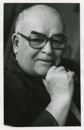
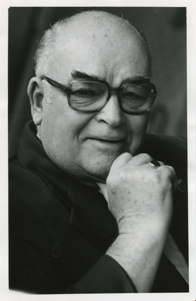
Bacon, Bryan - Burnaby Librarian
https://search.heritageburnaby.ca/link/archivedescription58811
- Repository
- City of Burnaby Archives
- Date
- ca.1975
- Collection/Fonds
- Columbian Newspaper collection
- Description Level
- Item
- Physical Description
- 1 Photograph : b&w ; 8 x 5 cm
- Scope and Content
- Photograph of Bryan Bacon, a Burnaby librarian.
- Repository
- City of Burnaby Archives
- Date
- ca.1975
- Collection/Fonds
- Columbian Newspaper collection
- Physical Description
- 1 Photograph : b&w ; 8 x 5 cm
- Description Level
- Item
- Record No.
- 480-1272
- Access Restriction
- No restrictions
- Reproduction Restriction
- May be restricted by third party rights
- Accession Number
- 2009-01
- Scope and Content
- Photograph of Bryan Bacon, a Burnaby librarian.
- Names
- Burnaby Public Library
- Media Type
- Photograph
- Notes
- Title based on contents of photograph
Images
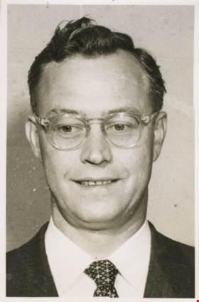
Arminson, George - Burnaby Sanitation
https://search.heritageburnaby.ca/link/archivedescription58829
- Repository
- City of Burnaby Archives
- Date
- ca.1970
- Collection/Fonds
- Columbian Newspaper collection
- Description Level
- Item
- Physical Description
- 1 photograph : b&w ; 8 x 5.5 cm
- Scope and Content
- Photograph of George Arminson from Burnaby Sanitation.
- Repository
- City of Burnaby Archives
- Date
- ca.1970
- Collection/Fonds
- Columbian Newspaper collection
- Physical Description
- 1 photograph : b&w ; 8 x 5.5 cm
- Description Level
- Item
- Record No.
- 480-1290
- Access Restriction
- No restrictions
- Reproduction Restriction
- May be restricted by third party rights
- Accession Number
- 2009-01
- Scope and Content
- Photograph of George Arminson from Burnaby Sanitation.
- Names
- Armison, George
- Media Type
- Photograph
- Notes
- Title based on contents of photograph
Images

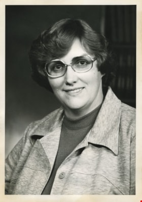
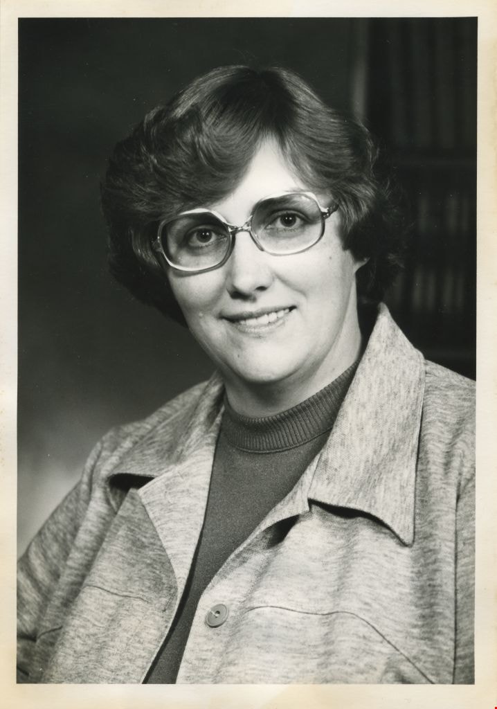
Beamish, Joanne - Lawyer
https://search.heritageburnaby.ca/link/archivedescription58839
- Repository
- City of Burnaby Archives
- Date
- ca.1975
- Collection/Fonds
- Columbian Newspaper collection
- Description Level
- Item
- Physical Description
- 1 photograph : b&w ; 18 x 12.5 cm
- Scope and Content
- Photographic portrait of Joanne Beamish, a lawyer.
- Repository
- City of Burnaby Archives
- Date
- ca.1975
- Collection/Fonds
- Columbian Newspaper collection
- Physical Description
- 1 photograph : b&w ; 18 x 12.5 cm
- Description Level
- Item
- Record No.
- 480-1300
- Access Restriction
- No restrictions
- Reproduction Restriction
- May be restricted by third party rights
- Accession Number
- 2009-01
- Scope and Content
- Photographic portrait of Joanne Beamish, a lawyer.
- Names
- Beamish, Joanne
- Media Type
- Photograph
- Photographer
- Doner, Allan
- Notes
- Title based on contents of photograph
Images
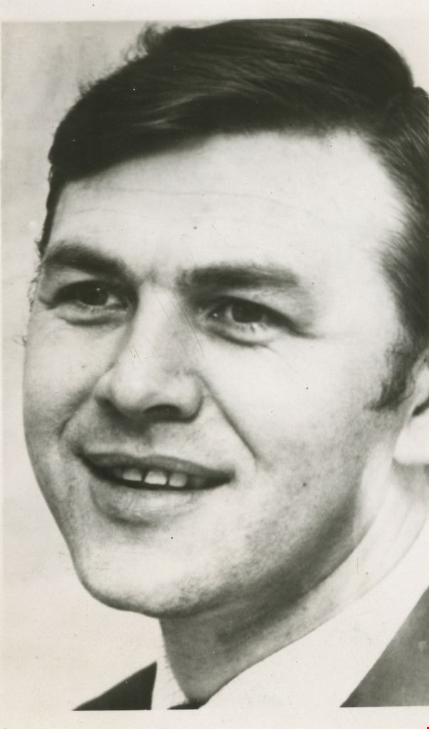
Barrington, Jim - Burnaby Politics
https://search.heritageburnaby.ca/link/archivedescription58844
- Repository
- City of Burnaby Archives
- Date
- ca.1970
- Collection/Fonds
- Columbian Newspaper collection
- Description Level
- Item
- Physical Description
- 1 photograph : b&w ; 17.5 x 10 cm
- Scope and Content
- Photograph of former Parks Commissioner, and the 1983 Freeman of Burnaby James Alfred "Jim" Barrington.
- Repository
- City of Burnaby Archives
- Date
- ca.1970
- Collection/Fonds
- Columbian Newspaper collection
- Physical Description
- 1 photograph : b&w ; 17.5 x 10 cm
- Description Level
- Item
- Record No.
- 480-1305
- Access Restriction
- No restrictions
- Reproduction Restriction
- May be restricted by third party rights
- Accession Number
- 2009-01
- Scope and Content
- Photograph of former Parks Commissioner, and the 1983 Freeman of Burnaby James Alfred "Jim" Barrington.
- Subjects
- Officials - Commissioners
- Media Type
- Photograph
- Photographer
- King, Basil
- Notes
- Title based on contents of photograph
- Note on recto reads "This one I like - AND I know the guy Basil"
- Note on verso of photograph reads: "James Barrington"
- Photographer's stamp on verso of photograph
Images
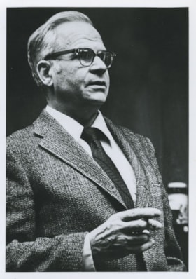
Goldmark, Dr. Peter - SFU
https://search.heritageburnaby.ca/link/archivedescription58869
- Repository
- City of Burnaby Archives
- Date
- ca.1974
- Collection/Fonds
- Columbian Newspaper collection
- Description Level
- Item
- Physical Description
- 1 photograph : b&w ; 18 x 12.5 cm
- Scope and Content
- Photograph of Dr. Peter Goldmark speaking in the Simon Fraser University Theatre.
- Repository
- City of Burnaby Archives
- Date
- ca.1974
- Collection/Fonds
- Columbian Newspaper collection
- Physical Description
- 1 photograph : b&w ; 18 x 12.5 cm
- Description Level
- Item
- Record No.
- 480-1329
- Access Restriction
- No restrictions
- Reproduction Restriction
- May be restricted by third party rights
- Accession Number
- 2009-01
- Scope and Content
- Photograph of Dr. Peter Goldmark speaking in the Simon Fraser University Theatre.
- Names
- Simon Fraser University
- Media Type
- Photograph
- Notes
- Title based on contents of photograph
- Note attached to verso of photograph reads: "SFU Theatre / Simon Fraser University / Dr. Peter GOldmark / Appearing at SFU Theatre / Friday, March 8, 1974, 12:30 pm / "A CONVERSATION WITH DR. PETER GOLDMARK"
Images


Shell Oil Company
https://search.heritageburnaby.ca/link/landmark675
- Repository
- Burnaby Heritage Planning
- Geographic Access
- Kensington Avenue
- Associated Dates
- ca. 1930-1993
- Heritage Value
- After considering several sites in the Greater Vancouver area, the Shell Oil Company chose 70 acres in North Burnaby with frontage of one third of a mile on Burrard Inlet. Shell proposed to build a four-million dollar plant that would employ up to 2000 - providing some relief in the middle of Burnaby's economic crisis of the Depression years. The site became known as the Shellburn Refinery and was in operation until 1993.
- Historic Neighbourhood
- Lochdale (Historic Neighbourhood)
- Planning Study Area
- Westridge Area
Images


Riverside School
https://search.heritageburnaby.ca/link/landmark711
- Repository
- Burnaby Heritage Planning
- Geographic Access
- Marine Drive
- Associated Dates
- 1953-1983
- Heritage Value
- The south-east corner of Burnaby featured homes that were scattered in a rural setting. Previously, Riverway East and then Clinton Elementary School had served this neighbourhood, but a more central location was preferable to the School Board to limit bussing of students, so Riverside School was opened in 1953. There were 84 students registered in its first year, but by the late 1970s, enrolments across the City had declined and a number of schools, including Riverside, were closed.
- Historic Neighbourhood
- Fraser Arm (Historic Neighbourhood)
- Planning Study Area
- Big Bend Area
Images


Burnaby North High School
https://search.heritageburnaby.ca/link/landmark745
- Repository
- Burnaby Heritage Planning
- Associated Dates
- 1923-1982
- Street View URL
- Google Maps Street View
- Repository
- Burnaby Heritage Planning
- Geographic Access
- Willingdon Avenue
- Associated Dates
- 1923-1982
- Heritage Value
- Burnaby North and Burnaby South were the first high schools built in the City. Before the high school opened, Burnaby students had to travel to Vancouver if they wished to pursue education beyond an elementary level. In 1921, arrangements were made to use the basement of the Presbyterian Church for instruction of local students. By 1922 the Burnaby North High School opened at its first permanent location (4375 Pandora Street - which is now Rosser Elementary). In 1945, the Willingdon Avenue site was built and was used until a new building was constructed in 1961 on Hammarskjold Drive. From 1962, the school was used as Burnaby Heights Junior High school, but it closed in 1982 and the junior high students went to the new Burnaby North on Hammarskjold.
- Historic Neighbourhood
- Capitol Hill (Historic Neighbourhood)
- Planning Study Area
- Capitol Hill Area
- Street Address
- 250 Willingdon Avenue
- Street View URL
- Google Maps Street View
Images


Burnaby South High School
https://search.heritageburnaby.ca/link/landmark770
- Repository
- Burnaby Heritage Planning
- Associated Dates
- 1922-1988
- Street View URL
- Google Maps Street View
- Repository
- Burnaby Heritage Planning
- Geographic Access
- Southoaks Crescent
- Associated Dates
- 1922-1988
- Heritage Value
- Burnaby South and Burnaby North were Burnaby's first high schools. The first rooms of the school were built in 1922 on the same grounds as the Kingsway East Elementary School. In 1940, a two-storey building was erected and additions were made in 1963, 1967 and 1972. Kingsway East closed in 1925 and its buildings were used by the high school for Industrial Arts and Home Economics. In the early 1990s, a new "urban education centre" (Burnaby South/B.C. School for the Deaf) was opened, replacing the old Burnaby South High School.
- Historic Neighbourhood
- Edmonds (Historic Neighbourhood)
- Planning Study Area
- Kingsway-Beresford Area
- Street Address
- 6650 Southoaks Crescent
- Street View URL
- Google Maps Street View
Images


Burnaby Heights Neighbourhood
https://search.heritageburnaby.ca/link/landmark776
- Repository
- Burnaby Heritage Planning
- Associated Dates
- 1955-2008
- Heritage Value
- Up until the 1970s, this neighbourhood was known as Vancouver Heights. When a new park was created during that decade and named "Burnaby Heights Park," the name was gradually adopted by newcomers to the area. Today, you will hear residents refer to their neighbourhood as Burnaby Heights, Vancouver Heights, or just "The Heights." Throughout the 1960s and 1970s, the commercial district in this neighbourhood continued to grow and a Retail Merchants Association was formed which later became known as the Heights Merchants Association. The neighbourhood still retains a residential neighbourhood characteristic with an increasing number of apartment buildings and multi-family units being built over the past 20 years.
- Historic Neighbourhood
- Vancouver Heights (Historic Neighbourhood)
- Planning Study Area
- Burnaby Heights Area
Images


Willingdon Heights Neighbourhood
https://search.heritageburnaby.ca/link/landmark777
- Repository
- Burnaby Heritage Planning
- Associated Dates
- 1955-2008
- Heritage Value
- The convenient location of Willingdon Heights to the Trans Canada Highway, Lougheed Highway and Hastings Street has fostered its development as a primarily residential commuter neighbourhood. Characterised in the post-World War Two period by predominantly single-family developments, the neighbourhood has retained this identity despite some higher density apartment buildings now found there.
- Planning Study Area
- Willingdon Heights Area
Images


West Central Valley Neighbourhood
https://search.heritageburnaby.ca/link/landmark778
- Repository
- Burnaby Heritage Planning
- Associated Dates
- 1955-2008
- Heritage Value
- The West Central Valley Neighbourhood is home to the Bridge Business Park and is a primarily industrial neighbourhood. Similar to the adjacent Dawson-Delta Neighbourhood, West Central Valley offers businesses convenient access to major roads and highways.
- Historic Neighbourhood
- Broadview (Historic Neighbourhood)
- Planning Study Area
- West Central Valley Area
Images


Dawson-Delta Neighbourhood
https://search.heritageburnaby.ca/link/landmark779
- Repository
- Burnaby Heritage Planning
- Associated Dates
- 1955-2008
- Heritage Value
- The Dawson-Delta neighbourhood in Burnaby developed into one of Burnaby's numerous industrial areas after 1955. The Eastbrook Executive Business Park opened in the 1970s and the Willingdon Green Business Centre includes buildings from the 1980s to the 2000s. Convenient access to major roads and highways fostered these developments which remain zoned for industrial uses to this day.
- Planning Study Area
- Dawson-Delta Area
Images


Brentwood Neighbourhood
https://search.heritageburnaby.ca/link/landmark780
- Repository
- Burnaby Heritage Planning
- Associated Dates
- 1955-2008
- Heritage Value
- Between 1955 and 2001, the Brentwood Neighbourhood developed into one of Burnaby's four official Town Centres. The Brentwood Town Centre serves the north-west sector of the Municipality, providing facilities such as commercial developments - of which the Brentwood Mall is the most significant. Under Burnaby's Residential Development Framework adopted by Council in 1981, the Town Centre also incorporated a full range of multi-housing types and forms in close relationship with their commercial facilities. In 1996, the City adopted the Brentwood Town Centre Development Plant to solidify the area as a focus of higher-density and higher-intensity residential and commercial opportunities, public transit and supporting leisure facilities.
- Planning Study Area
- Brentwood Area
Images


Capitol Hill Neighbourhood
https://search.heritageburnaby.ca/link/landmark781
- Repository
- Burnaby Heritage Planning
- Associated Dates
- 1955-2008
- Heritage Value
- The Capitol Hill Neighbourhood remained a primarily residential neighbourhood after the population boom of the 1950s and 1960s. The commercial focus remained the Hastings Street corridor, while the City of Burnaby moved to protect a conservation area on the north side of Capitol Hill and dedicated parkland throughout the 1970s and 1980s.
- Historic Neighbourhood
- Capitol Hill (Historic Neighbourhood)
- Planning Study Area
- Capitol Hill Area
Images


Parkcrest-Aubrey Neighbourhood
https://search.heritageburnaby.ca/link/landmark782
- Repository
- Burnaby Heritage Planning
- Associated Dates
- 1955-2008
- Heritage Value
- After its initial subdivision and development in the early 1950s, the Parkcrest-Audrey Neighbourhood continued to be a primarily residential area. In the 1980 Residential Neighbourhood Environment Study, the area was characterised as a stable residential neighbourhood that was served by the major collector streets Holdom, Broadway, Parker and Kensington.
- Planning Study Area
- Parkcrest-Aubrey Area
Images


Sperling-Broadway Neighbourhood
https://search.heritageburnaby.ca/link/landmark789
- Repository
- Burnaby Heritage Planning
- Associated Dates
- 1955-2008
- Heritage Value
- By the 1970s, the Sperling-Broadway Neighbourhood was characterised as one of the Municipality's fastest growing residential areas. In 1980, it was estimated that slightly less than half of the homes were single-family residences, while the remaining development was taking the form of townhouse and high-rise apartments. The emphasis shifted back to single family housing during the construction of planned subdivisions such as the Camrose subdivision in the 1980s and the area remains primarily residential in nature. The neighbourhood is well-served by park facilities and is also home to the Burnaby Mountain Golf Course.
- Historic Neighbourhood
- Lochdale (Historic Neighbourhood)
- Planning Study Area
- Sperling-Broadway Area
Images


Lochdale Neighbourhood
https://search.heritageburnaby.ca/link/landmark790
- Repository
- Burnaby Heritage Planning
- Associated Dates
- 1955-2008
- Heritage Value
- Despite the rapid growth witnessed in Burnaby in the post-war years, the Lochdale Neighbourhood was characterised as a close-knit primarily residential community. Although a commercial zone developed along Sperling and Hastings, single-family, duplex and multi-family homes were the primary buildings in the area. Basement suites and student accommodation also flourished in this neighbourhood after the creation of Simon Fraser University on Burnaby Mountain.
- Historic Neighbourhood
- Lochdale (Historic Neighbourhood)
- Planning Study Area
- Lochdale Area
Images


Westridge Neighbourhood
https://search.heritageburnaby.ca/link/landmark791
- Repository
- Burnaby Heritage Planning
- Associated Dates
- 1955-2008
- Heritage Value
- The Westridge Neighbourhood is effectively separated into two areas by Inlet Drive. To the west of the highway lies a typical 1950s subdivision of single-family homes, while to the east is a newer (1970s) subdivision featuring larger lots and some low-rise units. In the 1980 Residential Neighbourhood Environment Study, Westridge was characterised as a stable community with little need for direct Municipal involvement in growth and development.
- Historic Neighbourhood
- Lochdale (Historic Neighbourhood)
- Planning Study Area
- Westridge Area
Images


Burnaby Mountain Neighbourhood
https://search.heritageburnaby.ca/link/landmark792
- Repository
- Burnaby Heritage Planning
- Associated Dates
- 1955-2008
- Heritage Value
- Burnaby Mountain had been dedicated as park in 1942, however the original park boundaries were reconsidered in 1952 with the development of the Trans Mountain Pipeline. Although the boundaries were adjusted to accommodate this project, significant conservation and park lands were left untouched. When, in 1962, the government of British Columbia determined the need for additional post-secondary facilities, Burnaby Mountain was chosen as the site for the new Simon Fraser University which opened in 1965. As early as 1964, the idea of establishing a townsite around the university had been discussed by Burnaby, but it was not until the mid-1990s that the idea came to fruition and by the early 2000s, a new housing development know as the UniverCity took shape on the mountain adjacent to the university.
- Historic Neighbourhood
- Barnet (Historic Neighbourhood)
- Planning Study Area
- Burnaby Mountain Area
Images
