Narrow Results By
Decade
- 2020s 224
- 2010s 156
- 2000s
- 1990s 2874
- 1980s 1365
- 1970s
- 1960s 1356
- 1950s 1714
- 1940s 2182
- 1930s 2169
- 1920s 2529
- 1910s 2123
- 1900s 877
- 1890s 249
- 1880s 165
- 1870s 72
- 1860s 123
- 1850s 14
- 1840s 5
- 1830s 3
- 1820s 2
- 1810s 3
- 1800s 3
- 1790s 2
- 1780s 2
- 1770s 2
- 1760s 2
- 1750s 2
- 1740s 2
- 1730s 2
- 1720s 2
- 1710s 2
- 1700s 2
- 1690s 2
- 1680s 2
- 1670s 1
- 1660s 1
- 1650s 1
- 1640s 1
- 1630s 1
- 1620s 1
- 1610s 1
- 1600s
- 1590s 1
- 1580s 1
- 1570s 1
- 1560s 1
- 1550s 1
- 1540s 1
- 1530s 1
- 1520s 2
- 1510s 1
- 1500s 1
- 1490s 1
- 1480s 1
Subject
- Accidents 4
- Accidents - Automobile Accidents 7
- Accidents - Train Accidents 6
- Adminstrative Groups - Committees 4
- Adornment - Jewelry 1
- Adornment - Lapel Pins 1
- Advertising Medium 3
- Advertising Medium - Flyer 4
- Advertising Medium - Poster 15
- Advertising Medium - Signs and Signboards 83
- Aerial Photographs 46
- Agricultural Tools and Equipment - Gardening Equipment 1

Stride Avenue Neighbourhood
https://search.heritageburnaby.ca/link/landmark845
- Repository
- Burnaby Heritage Planning
- Associated Dates
- 1955-2008
- Heritage Value
- The interurban link between New Westminster and Vancouver stimulated the early settlement of Stride Avenue. Infilling of the area took place in the early 1950s and the pace of development had slowed considerably by 1970. Duplexes became a popular feature in the decade between 1970 and 1980 and in the late 1980s, the neighbourhood was incorporated into the Edmonds Town Centre South plan.
- Historic Neighbourhood
- Edmonds (Historic Neighbourhood)
- Planning Study Area
- Stride Avenue Area
Images


Stride Hill Neighbourhood
https://search.heritageburnaby.ca/link/landmark846
- Repository
- Burnaby Heritage Planning
- Associated Dates
- 1955-2008
- Heritage Value
- The residential areas that are located within the Stride Hill Neighbourhood were primarily developed in the 1950s during Burnaby's post-war building boom. The area lying to the south of Byrne Creek Ravine Park was used as a municipal garbage dump until the 1960s and as a landfill site for yard waste disposal until the early 1990s at which point the area was incorporated into the Edmonds Town Centre Plan and the land was made into park and open space.
- Historic Neighbourhood
- Edmonds (Historic Neighbourhood)
- Planning Study Area
- Stride Hill Area
Images


Suncrest Neighbourhood
https://search.heritageburnaby.ca/link/landmark839
- Repository
- Burnaby Heritage Planning
- Associated Dates
- 1955-2008
- Heritage Value
- The Suncrest Neighbourhood is a small residential area south of Burnaby's Central Park. The Ocean View Burial Park takes up a large area of land in the north-east corner of this neighbourhood and the majority of the housing was built during the 1930-1960 period.
- Historic Neighbourhood
- Alta Vista (Historic Neighbourhood)
- Planning Study Area
- Suncrest Area
Images


Sussex Avenue School
https://search.heritageburnaby.ca/link/landmark815
- Repository
- Burnaby Heritage Planning
- Geographic Access
- Irmin Street
- Associated Dates
- 1955-1982
- Heritage Value
- Sussex Avenue school was another school built during the peak expansion years of the 1950s and early 1960s. Burnaby's population was growing at such a fast pace during that decade that 10 new schools were built, and existing schools were expanded. Sussex Avenue School opened with 304 pupils. By the 1970s, student enrolment had slowed considerably from its peak and as a result, a number of schools - including Sussex - were closed.
- Historic Neighbourhood
- Alta Vista (Historic Neighbourhood)
- Planning Study Area
- Sussex-Nelson Area
- Street Address
- 4443 Irmin Street
Images

Sussex-Nelson Neighbourhood
https://search.heritageburnaby.ca/link/landmark838
- Repository
- Burnaby Heritage Planning
- Associated Dates
- 1955-2008
- Heritage Value
- The Sussex-Nelson Neighbourhood is located just south of Metrotown and in 1980 was characterised as the most populated of all of Burnaby's Planning Study areas. The area immediately south of Metrotown was initially developed as post-war 1950s housing stock, while the sector south of Rumble was developed after the 1960s and 1970s as single-family housing.
- Historic Neighbourhood
- Alta Vista (Historic Neighbourhood)
- Planning Study Area
- Sussex-Nelson Area
Images


Taylor Park Elementary School
https://search.heritageburnaby.ca/link/landmark847
- Repository
- Burnaby Heritage Planning
- Geographic Access
- Mission Avenue
- Associated Dates
- 2004
- Heritage Value
- Taylor Park Elementary School was opened in 2004 with 240 students from kindergarten to grade three (with older students attending Stride Avenue Community School). By 2006, Taylor Park had been designated as its own school and extended its classes from kindergarten through grade six.
- Historic Neighbourhood
- Edmonds (Historic Neighbourhood)
- Planning Study Area
- Stride Hill Area
- Street Address
- 7590 Mission Avenue
- Street View URL
- Google Maps Street View
Images


West Central Valley Neighbourhood
https://search.heritageburnaby.ca/link/landmark778
- Repository
- Burnaby Heritage Planning
- Associated Dates
- 1955-2008
- Heritage Value
- The West Central Valley Neighbourhood is home to the Bridge Business Park and is a primarily industrial neighbourhood. Similar to the adjacent Dawson-Delta Neighbourhood, West Central Valley offers businesses convenient access to major roads and highways.
- Historic Neighbourhood
- Broadview (Historic Neighbourhood)
- Planning Study Area
- West Central Valley Area
Images


Westridge Neighbourhood
https://search.heritageburnaby.ca/link/landmark791
- Repository
- Burnaby Heritage Planning
- Associated Dates
- 1955-2008
- Heritage Value
- The Westridge Neighbourhood is effectively separated into two areas by Inlet Drive. To the west of the highway lies a typical 1950s subdivision of single-family homes, while to the east is a newer (1970s) subdivision featuring larger lots and some low-rise units. In the 1980 Residential Neighbourhood Environment Study, Westridge was characterised as a stable community with little need for direct Municipal involvement in growth and development.
- Historic Neighbourhood
- Lochdale (Historic Neighbourhood)
- Planning Study Area
- Westridge Area
Images


Willingdon Heights Neighbourhood
https://search.heritageburnaby.ca/link/landmark777
- Repository
- Burnaby Heritage Planning
- Associated Dates
- 1955-2008
- Heritage Value
- The convenient location of Willingdon Heights to the Trans Canada Highway, Lougheed Highway and Hastings Street has fostered its development as a primarily residential commuter neighbourhood. Characterised in the post-World War Two period by predominantly single-family developments, the neighbourhood has retained this identity despite some higher density apartment buildings now found there.
- Planning Study Area
- Willingdon Heights Area
Images


Windsor Neighbourhood
https://search.heritageburnaby.ca/link/landmark803
- Repository
- Burnaby Heritage Planning
- Associated Dates
- 1955-2008
- Heritage Value
- The Windsor Neighbourhood comprises a number of different districts with different characteristics. To the north, stretching to the border of the Deer Lake Park, is the primarily residential area that was developed after the building boom of the 1950s and now consists of a mix of single-family and multi-family housing. To the south, from Kingsway to the Skytrain line, an industrial area was maintained along with a significant commercial corridor along Kingsway. In recent years, the growth and development of this area has been guided by the Royal Oak Community Plan adopted by Council in 1999.
- Planning Study Area
- Windsor Area
Images

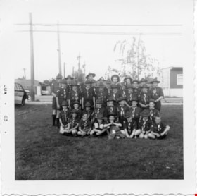
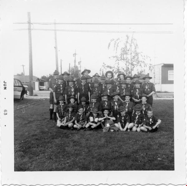
1st Burnaby West
https://search.heritageburnaby.ca/link/archivedescription55142
- Repository
- City of Burnaby Archives
- Date
- 1962-1973
- Collection/Fonds
- Burnaby Historical Society fonds
- Description Level
- File
- Physical Description
- 1 scrapbook
- Scope and Content
- Scrapbook containing photographs and newspaper clippings pertaining to the 1st Burnaby West Scout troop. Special events and fundraisers depicted in the photographs include: Father and Son banquets, family nights, Going Up ceremonies, colours presentations, bowling and skating events, Model Kub Car…
- Repository
- City of Burnaby Archives
- Date
- 1962-1973
- Collection/Fonds
- Burnaby Historical Society fonds
- Subseries
- Burnaby Scouts subseries
- Physical Description
- 1 scrapbook
- Material Details
- 418 photographs : b&w & col. ; 15 cm x 20 cm and smaller ; newspaper clippings
- Description Level
- File
- Record No.
- 631-043
- Access Restriction
- No restrictions
- Reproduction Restriction
- Reproduce for fair dealing purposes only
- Accession Number
- BHS1994-05
- Scope and Content
- Scrapbook containing photographs and newspaper clippings pertaining to the 1st Burnaby West Scout troop. Special events and fundraisers depicted in the photographs include: Father and Son banquets, family nights, Going Up ceremonies, colours presentations, bowling and skating events, Model Kub Car, Grand Howl, ladies auxiliary among others.
- Names
- Boy Scouts of Canada
- Media Type
- Photograph
- Notes
- Transcribed title
- Title transcribe from first album page
Images
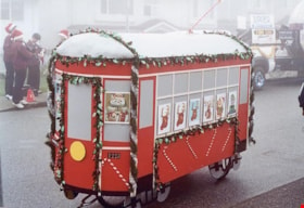
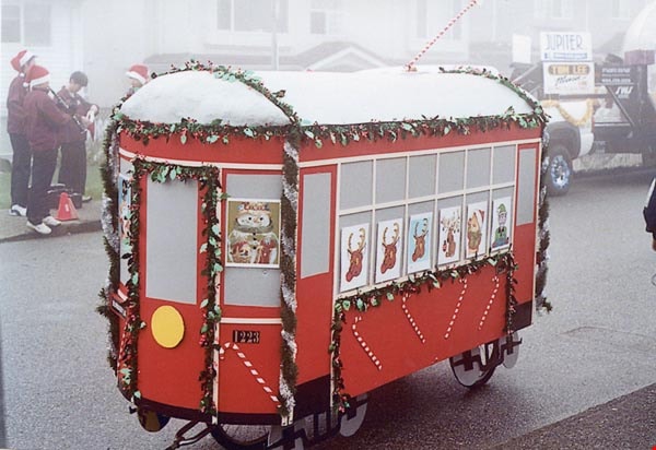
2nd Annual Burnaby Edmonds Lions Santa Claus Parade
https://search.heritageburnaby.ca/link/archivedescription98452
- Repository
- City of Burnaby Archives
- Date
- November 27, 2004
- Collection/Fonds
- Burnaby Historical Society fonds
- Description Level
- File
- Physical Description
- 51 photographs : col. ; 10 cm x 15 cm
- Scope and Content
- File contains photographs from the Edmonds Lions Santa Claus Parade on November 27, 2004, including the Burnaby Historical Society's float.
- Repository
- City of Burnaby Archives
- Date
- November 27, 2004
- Collection/Fonds
- Burnaby Historical Society fonds
- Series
- Administration series
- Physical Description
- 51 photographs : col. ; 10 cm x 15 cm
- Description Level
- File
- Record No.
- 633-007
- Access Restriction
- No restrictions
- Reproduction Restriction
- No restrictions
- Accession Number
- 2020-06
- Scope and Content
- File contains photographs from the Edmonds Lions Santa Claus Parade on November 27, 2004, including the Burnaby Historical Society's float.
- Subjects
- Events - Parades
- Holidays - Christmas
- Media Type
- Photograph
- Notes
- Transcribed title
- Title transcribed from photo album cover
- Photographs were originally contained in a photograph album and removed by Archives staff for preservation purposes. Original order of photographs within the album is maintained.
- Most photographs in file have note on verso identifying individuals depicted
- Note in blue ink on inside front cover of album read: "Our float was designed by Brian Elder / Photo work by Sid Combers / Construction by Brian, Sid and assisted by Dennis Brown / "Goofer" and "Nag" Cice Brown
- Caption for 633-007-1 is: "Base of float"
- Caption for 633-007-2 is: "One of our few pictures of Brian"
- Caption for 633-007-3 is: "Side, float and 1223"
- Caption for 633-007-4 is: "Pixie and float"
- Caption for 633-004-5 is: "Sid working"
- Caption for 633-007-6 is: "Try-out around the parking lot"
- Caption for 633-007-8 is: "Dennis and float ready to load David's truck"
- Caption for 633-007-9 is: "7.30 am at warehouse float on Dave's truck cold and foggy"
- Caption for 633-007-10 is: "Taken by Brian following David's truck"
- Caption for 633-007-11 is: "Waiting for the parade to start"
- Caption for 633-007-12 is: "Ready to go"
- Caption for 633-007-13 is: "Ready to move"
- Caption for 633-007-14 is: "Tall and short of it"
- Caption for 633-007-24 is: "David Brown Dennis Dian [sic] Holt Diane Herberts Carol Rush"
- Caption for 633-007-26 is: "John Whiting helping from the rear"
- Caption for 633-007-30 is: "Still pushing"
- Caption for 633-007-32 is: "Carol Rush President of B.H.S."
- Caption for 633-007-51 is: "Cice and Bob in BVM depot-hack"
Images

#6 Firehall
https://search.heritageburnaby.ca/link/archivedescription93703
- Repository
- City of Burnaby Archives
- Date
- February 15, 1978
- Collection/Fonds
- Burnaby Public Library Contemporary Visual Archive Project
- Description Level
- Item
- Physical Description
- 1 photograph : b&w ; 12.5 x 17.5 cm
- Scope and Content
- Photograph of the front exterior of Burnaby Fire Hall No. 6, located at 3620 Brighton Avenue, at the corner of Brighton Avenue and Government Street. The photograph is taken from across Brighton Avenue, facing east. One of the fire hall's garage doors is open and a person and car are inside. The Fu…
- Repository
- City of Burnaby Archives
- Date
- February 15, 1978
- Collection/Fonds
- Burnaby Public Library Contemporary Visual Archive Project
- Physical Description
- 1 photograph : b&w ; 12.5 x 17.5 cm
- Description Level
- Item
- Record No.
- 556-660
- Access Restriction
- No restrictions
- Reproduction Restriction
- Reproduce for fair dealing purposes only
- Accession Number
- 2017-57
- Scope and Content
- Photograph of the front exterior of Burnaby Fire Hall No. 6, located at 3620 Brighton Avenue, at the corner of Brighton Avenue and Government Street. The photograph is taken from across Brighton Avenue, facing east. One of the fire hall's garage doors is open and a person and car are inside. The Furniture Fair warehouse is visible behind the fire hall.
- Names
- Burnaby Fire Department
- Media Type
- Photograph
- Photographer
- Surridge, Jack
- Notes
- Title taken from project information form
- Accompanied by a project information form and 1 photograph (b&w negative ; 9.5 x 12.5 cm)
- BPL no. 108
- Geographic Access
- Government Street
- Brighton Avenue
- Street Address
- 3620 Brighton Avenue
- Historic Neighbourhood
- Lozells (Historic Neighbourhood)
- Planning Study Area
- Government Road Area
Images

![10th Avenue connector construction, [2002] thumbnail](/media/hpo/_Data/_Archives_Images/_Unrestricted/535/535-1984.jpg?width=280)
10th Avenue connector construction
https://search.heritageburnaby.ca/link/archivedescription96301
- Repository
- City of Burnaby Archives
- Date
- [2002]
- Collection/Fonds
- Burnaby NewsLeader photograph collection
- Description Level
- Item
- Physical Description
- 1 photograph (tiff) : col.
- Scope and Content
- Photograph of the view of the new 10th Avenue connector from Gord Thorneycroft's garage. Thorneycroft holds a mug and is silhouetted by the light coming from outside, where the Bombardier SkyTrain plant is visible in the distance.
- Repository
- City of Burnaby Archives
- Date
- [2002]
- Collection/Fonds
- Burnaby NewsLeader photograph collection
- Physical Description
- 1 photograph (tiff) : col.
- Description Level
- Item
- Record No.
- 535-1984
- Access Restriction
- No restrictions
- Reproduction Restriction
- No restrictions
- Accession Number
- 2018-12
- Scope and Content
- Photograph of the view of the new 10th Avenue connector from Gord Thorneycroft's garage. Thorneycroft holds a mug and is silhouetted by the light coming from outside, where the Bombardier SkyTrain plant is visible in the distance.
- Media Type
- Photograph
- Photographer
- Bartel, Mario
- Notes
- Title based on caption
- Collected by editorial for use in a February 2002 issue of the Burnaby NewsLeader
- Caption from metadata: "Gord Thorneycroft says he used to be able to enjoy his morning coffee looking out onto a quiet, tree-lined lane while working in his garage behind his home on 9th Ave. But workers building the new 10th Ave. connector tore out the trees last September, the City of Burnaby isn't making any promises to erect noise barriers, and his lane has become a thoroughfare to the Bombardier Skytrain plant."
- Geographic Access
- 10th Avenue
- Historic Neighbourhood
- Edmonds (Historic Neighbourhood)
- Planning Study Area
- Stride Avenue Area
Images
![10th Avenue connector construction, [2002] thumbnail](/media/hpo/_Data/_Archives_Images/_Unrestricted/535/535-1984.jpg)
![24 Hour Relay for Kids, [2001] thumbnail](/media/hpo/_Data/_Archives_Images/_Unrestricted/535/535-2507.jpg?width=280)
24 Hour Relay for Kids
https://search.heritageburnaby.ca/link/archivedescription96952
- Repository
- City of Burnaby Archives
- Date
- [2001]
- Collection/Fonds
- Burnaby NewsLeader photograph collection
- Description Level
- Item
- Physical Description
- 1 photograph (tiff) : col.
- Scope and Content
- Photograph of two unidentified runners handing a baton to each other at the start/finish line during the 24 Hour Relay for Kids fundraising event for Easter Seals Camps at Swangard Stadium. Other relay runners wait in the background and the stadium's stands are filled with spectators.
- Repository
- City of Burnaby Archives
- Date
- [2001]
- Collection/Fonds
- Burnaby NewsLeader photograph collection
- Physical Description
- 1 photograph (tiff) : col.
- Description Level
- Item
- Record No.
- 535-2507
- Access Restriction
- No restrictions
- Reproduction Restriction
- No restrictions
- Accession Number
- 2018-12
- Scope and Content
- Photograph of two unidentified runners handing a baton to each other at the start/finish line during the 24 Hour Relay for Kids fundraising event for Easter Seals Camps at Swangard Stadium. Other relay runners wait in the background and the stadium's stands are filled with spectators.
- Names
- Swangard Stadium
- Media Type
- Photograph
- Photographer
- Bartel, Mario
- Notes
- Title based on caption
- Collected by editorial for use in a June 2001 issue of the Burnaby NewsLeader
- Caption from metadata: "Runners hand off to each other at the hectic Start/Finish area in the early-going of The 24 Hour Relay for the Kids, held all weekend at Swangard Stadium. The annual event attracted more than 2400 runners on 120 teams, who covered almost 18,000 miles to raise money to send kids to Easter Seal Camps around BC."
- Geographic Access
- Central Park
- Imperial Street
- Street Address
- 3883 Imperial Street
- Historic Neighbourhood
- Central Park (Historic Neighbourhood)
- Planning Study Area
- Maywood Area
Images
![24 Hour Relay for Kids, [2001] thumbnail](/media/hpo/_Data/_Archives_Images/_Unrestricted/535/535-2507.jpg)
![24 Hour Relay for the Kids, [2000] thumbnail](/media/hpo/_Data/_Archives_Images/_Unrestricted/535/535-2449.jpg?width=280)
24 Hour Relay for the Kids
https://search.heritageburnaby.ca/link/archivedescription96891
- Repository
- City of Burnaby Archives
- Date
- [2000]
- Collection/Fonds
- Burnaby NewsLeader photograph collection
- Description Level
- Item
- Physical Description
- 1 photograph (tiff) : col.
- Scope and Content
- Photograph of crowd of runners at the starting line for the 21st annual 24 Hour Relay for the Kids at Swangard Stadium. The runners are starting from beneath a banner advertising the event and the stands in the background are filled with people.
- Repository
- City of Burnaby Archives
- Date
- [2000]
- Collection/Fonds
- Burnaby NewsLeader photograph collection
- Physical Description
- 1 photograph (tiff) : col.
- Description Level
- Item
- Record No.
- 535-2449
- Access Restriction
- No restrictions
- Reproduction Restriction
- No restrictions
- Accession Number
- 2018-12
- Scope and Content
- Photograph of crowd of runners at the starting line for the 21st annual 24 Hour Relay for the Kids at Swangard Stadium. The runners are starting from beneath a banner advertising the event and the stands in the background are filled with people.
- Names
- Swangard Stadium
- Media Type
- Photograph
- Photographer
- Bartel, Mario
- Notes
- Title based on caption
- Collected by editorial for use in a June 2000 issue of the Burnaby NewsLeader
- Caption from metadata: "Runners from 145 teams start the 21st annual 24 Hour Relay for the Kids at Swangard Stadium. Money raised by the relay goes towards funding one-week camping trips for children with disabilities."
- Geographic Access
- Imperial Street
- Central Park
- Street Address
- 3883 Imperial Street
- Historic Neighbourhood
- Central Park (Historic Neighbourhood)
- Planning Study Area
- Maywood Area
Images
![24 Hour Relay for the Kids, [2000] thumbnail](/media/hpo/_Data/_Archives_Images/_Unrestricted/535/535-2449.jpg)
50th Anniversary 4th Guide Company
https://search.heritageburnaby.ca/link/museumdescription4949
- Repository
- Burnaby Village Museum
- Date
- Nov 3, 1976
- Collection/Fonds
- Burnaby Girl Guides fonds
- Description Level
- Item
- Physical Description
- 1 photograph : col. 9 x 12.5 cm
- Scope and Content
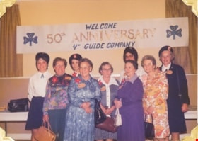
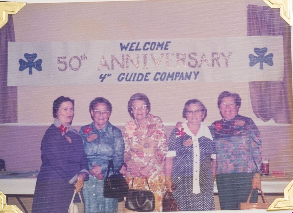
- Photograph of members of 4th Guide Company standing in front of a sign which reads "Welcome / 50th Anniversary / 4th Guide Company". Guiders in back row are identified from L to R as: Mrs. Dumka (Lt.), Mrs. Florence Underhill (Div. Comm.), Mrs. Kent (Dist. Comm), Mrs. Vivian E.S. Henderson (Area Co…
- Repository
- Burnaby Village Museum
- Collection/Fonds
- Burnaby Girl Guides fonds
- Description Level
- Item
- Physical Description
- 1 photograph : col. 9 x 12.5 cm
- Scope and Content
- Photograph of members of 4th Guide Company standing in front of a sign which reads "Welcome / 50th Anniversary / 4th Guide Company". Guiders in back row are identified from L to R as: Mrs. Dumka (Lt.), Mrs. Florence Underhill (Div. Comm.), Mrs. Kent (Dist. Comm), Mrs. Vivian E.S. Henderson (Area Comm.); Front row L to R: Mrs. Alice Thomas (Ellett), Mrs. Meta-Fay Miskell (Peden), Miss May Kelly, Miss Bessie Kelly, Mrs. Bristow (original guide captain).
- Other Title Information
- Title based on contents of photograph.
- Names
- Bristow, Dorothy
- Kent, Dorothy
- Kelly, May
- Kelly, Bessie
- Underhill, Florence
- Thomas, Alice Ellett
- Miskell, Meta Fay Peden
- Henderson, Vivian
- Girl Guides of Canada
- Accession Code
- BV015.35.285
- Access Restriction
- No restrictions
- Reproduction Restriction
- May be restricted by third party rights
- Date
- Nov 3, 1976
- Media Type
- Photograph
- Scan Resolution
- 600
- Scan Date
- 05/11/2018
- Notes
- Photograph is part of scrapbook BV015.35.166
Images

50th Anniversary 4th Guide Company
https://search.heritageburnaby.ca/link/museumdescription4950
- Repository
- Burnaby Village Museum
- Date
- Nov 3, 1976
- Collection/Fonds
- Burnaby Girl Guides fonds
- Description Level
- Item
- Physical Description
- 1 photograph : col. 9 x 12.5 cm
- Scope and Content
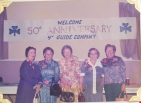
- Photograph of members of 4th Guide Company standing in front of a sign which reads "Welcome / 50th Anniversary / 4th Guide Company". Guiders are identified as: Center--Mrs. Bristow (original guide captain). L to R: Miss Bessie Kelly, Mrs. Meta-Fay Miskell (Peden), Miss May Kelly, Mrs. Alice Thomas…
- Repository
- Burnaby Village Museum
- Collection/Fonds
- Burnaby Girl Guides fonds
- Description Level
- Item
- Physical Description
- 1 photograph : col. 9 x 12.5 cm
- Scope and Content
- Photograph of members of 4th Guide Company standing in front of a sign which reads "Welcome / 50th Anniversary / 4th Guide Company". Guiders are identified as: Center--Mrs. Bristow (original guide captain). L to R: Miss Bessie Kelly, Mrs. Meta-Fay Miskell (Peden), Miss May Kelly, Mrs. Alice Thomas (Ellett). "These Ladies were guides with the original company".
- Other Title Information
- Title based on contents of photograph
- Names
- Bristow, Dorothy
- Kent, Dorothy
- Kelly, May
- Kelly, Bessie
- Underhill, Florence
- Thomas, Alice Ellett
- Miskell, Meta Fay Peden
- Henderson, Vivian
- Girl Guides of Canada
- Accession Code
- BV015.35.286
- Access Restriction
- No restrictions
- Reproduction Restriction
- May be restricted by third party rights
- Date
- Nov 3, 1976
- Media Type
- Photograph
- Scan Resolution
- 600
- Scan Date
- 05/11/2018
- Notes
- Photograph is part of scrapbook BV015.35.166
Images

50th Anniversary 4th Guide Company cake
https://search.heritageburnaby.ca/link/museumdescription4951
- Repository
- Burnaby Village Museum
- Date
- Nov 3, 1976
- Collection/Fonds
- Burnaby Girl Guides fonds
- Description Level
- Item
- Physical Description
- 1 photograph : col. 9 x 12.5 cm
- Scope and Content
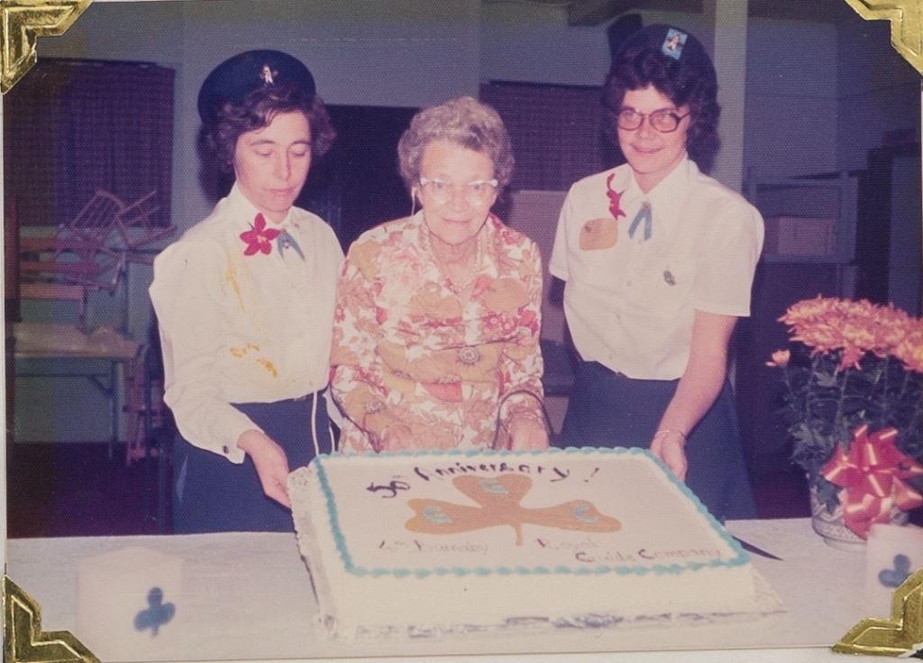
- Photograph of members of 4th Guide Company standing with a cake which reads "50th Anniversary / 4th Burnaby Royal Guide Company". Guiders are identified L to R Miss Jean Simmons, Mrs. Dorothy Bristow (original guide leader), Mrs. Ann Kent.
- Repository
- Burnaby Village Museum
- Collection/Fonds
- Burnaby Girl Guides fonds
- Description Level
- Item
- Physical Description
- 1 photograph : col. 9 x 12.5 cm
- Scope and Content
- Photograph of members of 4th Guide Company standing with a cake which reads "50th Anniversary / 4th Burnaby Royal Guide Company". Guiders are identified L to R Miss Jean Simmons, Mrs. Dorothy Bristow (original guide leader), Mrs. Ann Kent.
- Other Title Information
- Title based on contents of photograph
- Accession Code
- BV015.35.287
- Access Restriction
- No restrictions
- Reproduction Restriction
- May be restricted by third party rights
- Date
- Nov 3, 1976
- Media Type
- Photograph
- Scan Resolution
- 600
- Scan Date
- 05/11/2018
- Notes
- Photograph is part of scrapbook BV015.35.166
Images
![50th Anniversary G.G.C., [1926-1979] thumbnail](/media/hpo/_Data/_BVM_Images/2015/2015_0035_0166_folded_redacted.jpg?width=280)
50th Anniversary G.G.C.
https://search.heritageburnaby.ca/link/museumdescription4594
- Repository
- Burnaby Village Museum
- Date
- [1926-1979]
- Collection/Fonds
- Burnaby Girl Guides fonds
- Description Level
- File
- Physical Description
- 1 scrapbook (51 photographs + 1 postcard + textual records)
- Scope and Content
- File consists of a scrapbook with a handpainted wood cover titled "50th Anniversary / G.G.C". The scrapbook documents events and ceremonies of the 4th Guide Company with the first half of the scrapbook containing photographs and documents regarding the 50th Anniversary of Girl Guides which was cele…
- Repository
- Burnaby Village Museum
- Collection/Fonds
- Burnaby Girl Guides fonds
- Description Level
- File
- Physical Description
- 1 scrapbook (51 photographs + 1 postcard + textual records)
- Scope and Content
- File consists of a scrapbook with a handpainted wood cover titled "50th Anniversary / G.G.C". The scrapbook documents events and ceremonies of the 4th Guide Company with the first half of the scrapbook containing photographs and documents regarding the 50th Anniversary of Girl Guides which was celebrated at St. Nicholas Church in 1960 while the second half documents earlier events from 1926, as well as other events in the 1960s such as; "Year of the Golden Jubilee", a parade in North Burnaby as well as Thinking Day 1976-1978, banquets, a disco contest, camping on Hollyburn mountain and a visit to Victoria in 1979. On November 3rd, 1926 the company was registered as the 5th Burnaby Guide company, in 1951 the number was changed to the 4th Vancouver Guide Company and in 1956 the number was changed to the 4th Burnaby Company.
- Accession Code
- BV015.35.166
- Access Restriction
- No restrictions
- Reproduction Restriction
- May be restricted by third party rights
- Date
- [1926-1979]
- Media Type
- Textual Record
- Photograph
- Notes
- Transcribed title
- Items within scrapbook have been redacted in compliance with Section 22 of FIPPA
- A selection of photographs are described at item level (BV015.35.285 to BV.015.35.300).
Images
![50th Anniversary G.G.C., [1926-1979] thumbnail](/media/hpo/_Data/_BVM_Images/2015/2015_0035_0166_folded_redacted.jpg)