Narrow Results By
Decade
- 2020s 224
- 2010s 155
- 2000s 1822
- 1990s 2872
- 1980s 1365
- 1970s
- 1960s 1354
- 1950s 1707
- 1940s 2171
- 1930s 2157
- 1920s 2494
- 1910s 2123
- 1900s
- 1890s 248
- 1880s 165
- 1870s 72
- 1860s 123
- 1850s 14
- 1840s 5
- 1830s 3
- 1820s 2
- 1810s 3
- 1800s 3
- 1790s 2
- 1780s 2
- 1770s 2
- 1760s 2
- 1750s 2
- 1740s 2
- 1730s 2
- 1720s 2
- 1710s 2
- 1700s 2
- 1690s 2
- 1680s 2
- 1670s 1
- 1660s 1
- 1650s 1
- 1640s 1
- 1630s 1
- 1620s 1
- 1610s 1
- 1600s
- 1590s 1
- 1580s 1
- 1570s 1
- 1560s 1
- 1550s 1
- 1540s 1
- 1530s 1
- 1520s 2
- 1510s 1
- 1500s 1
- 1490s 1
- 1480s 1
Subject
- Accidents 1
- Accidents - Train Accidents 6
- Adminstrative Groups - Committees 4
- Adornment - Jewelry 1
- Advertising Medium 4
- Advertising Medium - Flyer 4
- Advertising Medium - Poster 15
- Advertising Medium - Signs and Signboards 75
- Aerial Photographs 46
- Agricultural Tools and Equipment 10
- Agriculture - Beekeeping 3
- Agriculture - Crops 16

West Central Valley Neighbourhood
https://search.heritageburnaby.ca/link/landmark778
- Repository
- Burnaby Heritage Planning
- Associated Dates
- 1955-2008
- Heritage Value
- The West Central Valley Neighbourhood is home to the Bridge Business Park and is a primarily industrial neighbourhood. Similar to the adjacent Dawson-Delta Neighbourhood, West Central Valley offers businesses convenient access to major roads and highways.
- Historic Neighbourhood
- Broadview (Historic Neighbourhood)
- Planning Study Area
- West Central Valley Area
Images


Westridge Neighbourhood
https://search.heritageburnaby.ca/link/landmark791
- Repository
- Burnaby Heritage Planning
- Associated Dates
- 1955-2008
- Heritage Value
- The Westridge Neighbourhood is effectively separated into two areas by Inlet Drive. To the west of the highway lies a typical 1950s subdivision of single-family homes, while to the east is a newer (1970s) subdivision featuring larger lots and some low-rise units. In the 1980 Residential Neighbourhood Environment Study, Westridge was characterised as a stable community with little need for direct Municipal involvement in growth and development.
- Historic Neighbourhood
- Lochdale (Historic Neighbourhood)
- Planning Study Area
- Westridge Area
Images


Willingdon Heights Neighbourhood
https://search.heritageburnaby.ca/link/landmark777
- Repository
- Burnaby Heritage Planning
- Associated Dates
- 1955-2008
- Heritage Value
- The convenient location of Willingdon Heights to the Trans Canada Highway, Lougheed Highway and Hastings Street has fostered its development as a primarily residential commuter neighbourhood. Characterised in the post-World War Two period by predominantly single-family developments, the neighbourhood has retained this identity despite some higher density apartment buildings now found there.
- Planning Study Area
- Willingdon Heights Area
Images


Windsor Neighbourhood
https://search.heritageburnaby.ca/link/landmark803
- Repository
- Burnaby Heritage Planning
- Associated Dates
- 1955-2008
- Heritage Value
- The Windsor Neighbourhood comprises a number of different districts with different characteristics. To the north, stretching to the border of the Deer Lake Park, is the primarily residential area that was developed after the building boom of the 1950s and now consists of a mix of single-family and multi-family housing. To the south, from Kingsway to the Skytrain line, an industrial area was maintained along with a significant commercial corridor along Kingsway. In recent years, the growth and development of this area has been guided by the Royal Oak Community Plan adopted by Council in 1999.
- Planning Study Area
- Windsor Area
Images


W.J. Walker House
https://search.heritageburnaby.ca/link/landmark548
- Repository
- Burnaby Heritage Planning
- Description
- The W.J. Walker House is a rustic cottage at the eastern end of Deer Lake and is now located within Deer Lake Park. It is a one-and-a-half-storey wood-frame shingle-clad vernacular structure.
- Associated Dates
- 1907
- Formal Recognition
- Heritage Designation, Community Heritage Register
- Other Names
- William & Olive Walker Residence
- Street View URL
- Google Maps Street View
- Repository
- Burnaby Heritage Planning
- Other Names
- William & Olive Walker Residence
- Geographic Access
- Sperling Avenue
- Associated Dates
- 1907
- Formal Recognition
- Heritage Designation, Community Heritage Register
- Enactment Type
- Bylaw No. 11593
- Enactment Date
- 15/09/2003
- Description
- The W.J. Walker House is a rustic cottage at the eastern end of Deer Lake and is now located within Deer Lake Park. It is a one-and-a-half-storey wood-frame shingle-clad vernacular structure.
- Heritage Value
- The W.J. Walker House is important as it references the economic activities in the Deer Lake area prior to the development of grand mansions in Deer Lake Park. It is typical of the cottages built by workers in the market gardening and lumber-milling industries that operated around the lake primarily from 1904-1925. This is the only cottage on the shores of Deer Lake remaining from the era when these industries were the focus of the area's development. The house demonstrates the aesthetic values of Olive Walker and her husband William J. Walker, a ‘rancher’ (market gardener, poultry farmer) who built the house as a retirement home, in the quality of its construction and interior finishing. The Craftsman styling of the house was a popular design vocabulary of the time and reflected the modern taste and values of the owner. The construction of the house also illustrates the use of locally milled lumber. The extant cold safe at the side of house is indicative of food storage methods in the early twentieth century and provides insight to the everyday domestic lives of people at this time.
- Defining Elements
- Key elements that define the heritage character of the W.J. Walker House include its: - location close to the lake and the site of the Deer Lake Lumber Company where the wood for construction of the house was milled - Craftsman style characteristics such as the house's orientation (front gable facing the street) and the combination of gable and double-pitched shed roofs - front entrance with its gabled porch supported by distinctive oversized diagonal brackets, and substantial front door of Douglas fir decorated with hand forged iron plates - cedar shingle siding - multiple-assembly wooden-sash casement windows with transoms - projecting cold safe - interior finishing that dates to the original construction of the house, such as the diagonally laid tongue-and-groove Douglas fir ceilings, wood panelled walls, and Clayburn brick fireplace
- Historic Neighbourhood
- Burnaby Lake (Historic Neighbourhood)
- Planning Study Area
- Morley-Buckingham Area
- Function
- Primary Current--Single Dwelling
- Primary Historic--Single Dwelling
- Community
- Burnaby
- Cadastral Identifier
- P.I.D. No. 017-105-773 Legal Description: Parcel 'A' (Reference Plan 3703), District Lot 85, Group 1, Except: Firstly: Parcel 'One' (Explanatory Plan 11350) Secondly: Parcel 2 (Reference Plan 35549) Group 1, New Westminster District.
- Boundaries
- The W.J. Walker House is comprised of a single municipally-owned property located at 5255 Sperling Avenue, Burnaby.
- Area
- 2,005.02
- Contributing Resource
- Building
- Landscape Feature
- Ownership
- Public (local)
- Documentation
- Heritage Site Files: PC77000 20. City of Burnaby Planning and Building Department, 4949 Canada Way, Burnaby, B.C., V5G 1M2
- Street Address
- 5255 Sperling Avenue
- Street View URL
- Google Maps Street View
Images


Woodward Cottage
https://search.heritageburnaby.ca/link/landmark496
- Repository
- Burnaby Heritage Planning
- Description
- Set far back from Sperling Avenue, Woodward Cottage is a one-storey, wood-frame house with a raised foundation and gabled roofline. It is located within a picturesque lakefront neighbourhood and is part of the Deer Lake Park Heritage Precinct.
- Associated Dates
- 1904
- Formal Recognition
- Community Heritage Register
- Other Names
- Maud & Harriet Woodward Cottage
- Street View URL
- Google Maps Street View
- Repository
- Burnaby Heritage Planning
- Other Names
- Maud & Harriet Woodward Cottage
- Geographic Access
- Sperling Avenue
- Associated Dates
- 1904
- Formal Recognition
- Community Heritage Register
- Enactment Type
- Council Resolution
- Enactment Date
- 26/05/2003
- Description
- Set far back from Sperling Avenue, Woodward Cottage is a one-storey, wood-frame house with a raised foundation and gabled roofline. It is located within a picturesque lakefront neighbourhood and is part of the Deer Lake Park Heritage Precinct.
- Heritage Value
- Woodward Cottage, built in 1904, is valued as the oldest house within the Deer Lake neighbourhood, whose construction marked the beginning of Deer Lake's transition from a rural farming community to a residential suburb. At the turn of the nineteenth century, Deer Lake was recognized for its tranquility and beautiful scenery, which, in turn, attracted New Westminster and Vancouver residents to relocate to the area and build family homes. The first owner, Maud Sarah Woodward (1865-1958), originally from England, was a pioneer nurse of Vancouver. In 1903, she purchased this property from her two close friends, Louis and Annie Hill, who were among Deer Lake's first residents. Maud and her sister, Harriet Julia Woodward (1879-1969), were prominent figures in the Deer Lake community and together they established the first post office in Burnaby, which operated out of this house. Due to the lack of any local facilities, in September 1904 Harriet Woodward established a private primary school here for the local children, which continued after 1908 as a kindergarten. The cottage was enlarged several times to accommodate the expanding post office until 1912, when the Woodwards began construction of a new, larger house. Woodward Cottage is also valued for its origins as an innovative prefabricated structure. In 1904, the B.C. Mills Timber and Trading Company patented a modular system in response to unprecedented population growth in the western provinces. This system could be adapted to provide everything from modest one-room cottages to schools, churches and banks. Short mill ends of lumber and siding, which had previously been discarded, were assembled into three or four-foot wide wall panels that could be bolted together. The vertical joints between the panels were covered by narrow battens, which gave these buildings their distinct appearance. The wall panels for the house were assembled at the mill, prepainted and packaged with various other components and the necessary instructions to assemble the building, and shipped via railway to its waiting customer. Woodward Cottage is one of the earliest surviving examples of this ingenious prefabricated system. In the 1930s, the cottage was raised and turned to allow for a new foundation to be built. Despite later additions and alterations, the original cottage form is still recognizable. Woodward Cottage is currently owned by the City of Burnaby and is part of the Deer Lake Park Heritage Precinct, Burnaby's most significant collection of historic sites.
- Defining Elements
- Key elements that define the heritage character of Woodward Cottage include its: - secluded lakefront site, set far back from Sperling Avenue, within the Deer Lake Park Heritage Precinct - residential form, scale and massing as expressed by its one-storey height and gabled roofline - original wood-frame construction and modular wall panels, extant under later stucco cladding - internal red-brick chimney - associated landscape features, including mature deciduous trees
- Historic Neighbourhood
- Burnaby Lake (Historic Neighbourhood)
- Planning Study Area
- Morley-Buckingham Area
- Organization
- Canadian Institute of Mining and Metallurgy
- Function
- Primary Historic--Single Dwelling
- Primary Current--Single Dwelling
- Community
- Deer Lake
- Cadastral Identifier
- P.I.D. 011-454-440
- Boundaries
- Woodward Cottage is comprised of a single residential lot located at 5141 Sperling Avenue, Burnaby.
- Area
- 6596
- Contributing Resource
- Building
- Ownership
- Public (local)
- Documentation
- City of Burnaby Planning and Building Department, Heritage Site Files
- Street Address
- 5141 Sperling Avenue
- Street View URL
- Google Maps Street View
Images


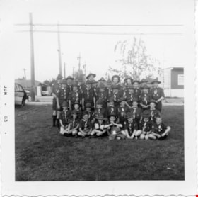
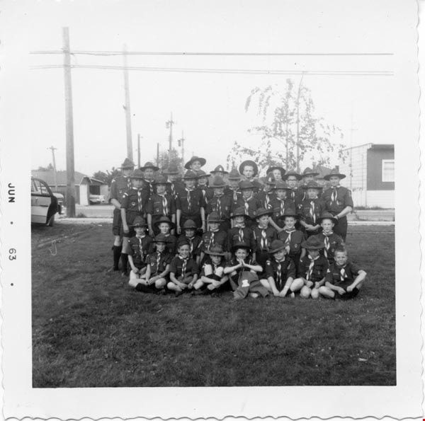
1st Burnaby West
https://search.heritageburnaby.ca/link/archivedescription55142
- Repository
- City of Burnaby Archives
- Date
- 1962-1973
- Collection/Fonds
- Burnaby Historical Society fonds
- Description Level
- File
- Physical Description
- 1 scrapbook
- Scope and Content
- Scrapbook containing photographs and newspaper clippings pertaining to the 1st Burnaby West Scout troop. Special events and fundraisers depicted in the photographs include: Father and Son banquets, family nights, Going Up ceremonies, colours presentations, bowling and skating events, Model Kub Car…
- Repository
- City of Burnaby Archives
- Date
- 1962-1973
- Collection/Fonds
- Burnaby Historical Society fonds
- Subseries
- Burnaby Scouts subseries
- Physical Description
- 1 scrapbook
- Material Details
- 418 photographs : b&w & col. ; 15 cm x 20 cm and smaller ; newspaper clippings
- Description Level
- File
- Record No.
- 631-043
- Access Restriction
- No restrictions
- Reproduction Restriction
- Reproduce for fair dealing purposes only
- Accession Number
- BHS1994-05
- Scope and Content
- Scrapbook containing photographs and newspaper clippings pertaining to the 1st Burnaby West Scout troop. Special events and fundraisers depicted in the photographs include: Father and Son banquets, family nights, Going Up ceremonies, colours presentations, bowling and skating events, Model Kub Car, Grand Howl, ladies auxiliary among others.
- Names
- Boy Scouts of Canada
- Media Type
- Photograph
- Notes
- Transcribed title
- Title transcribe from first album page
Images
![1st Div 1907 West Burnaby School, [1907] thumbnail](/media/hpo/_Data/_BVM_Images/2012/2012_0020_0002_001.jpg?width=280)
1st Div 1907 West Burnaby School
https://search.heritageburnaby.ca/link/museumdescription2939
- Repository
- Burnaby Village Museum
- Date
- [1907]
- Collection/Fonds
- Burnaby Village Museum Photograph collection
- Description Level
- Item
- Physical Description
- 1 photograph : b&w ; 13 x 8.2 cm
- Scope and Content
- Photograph of the First Division class for 1907 at West Burnaby School (later renamed Kingsway West School). There are two rows of students standing and one row of seated students. there is a male teacher standing on the left side of the group just beside a bicycle that is leaning against the build…
- Repository
- Burnaby Village Museum
- Collection/Fonds
- Burnaby Village Museum Photograph collection
- Description Level
- Item
- Physical Description
- 1 photograph : b&w ; 13 x 8.2 cm
- Material Details
- Handwritten in the photograph is "1st Div 1907 / West Burnaby School". The reverse side of the photograph is printed in a postcard format.
- Scope and Content
- Photograph of the First Division class for 1907 at West Burnaby School (later renamed Kingsway West School). There are two rows of students standing and one row of seated students. there is a male teacher standing on the left side of the group just beside a bicycle that is leaning against the building.
- Subjects
- Occupations - Teachers
- Persons - Students
- Names
- Kingsway West School
- Geographic Access
- Kingsway
- Street Address
- 4800 Kingsway
- Accession Code
- BV012.20.2
- Access Restriction
- No restrictions
- Reproduction Restriction
- No known restrictions
- Date
- [1907]
- Media Type
- Photograph
- Historic Neighbourhood
- Central Park (Historic Neighbourhood)
- Planning Study Area
- Maywood Area
- Scan Resolution
- 600
- Scan Date
- 13-Mar-2018
- Notes
- Title based on contents of photograph
Images
![1st Div 1907 West Burnaby School, [1907] thumbnail](/media/hpo/_Data/_BVM_Images/2012/2012_0020_0002_001.jpg)

#6 Firehall
https://search.heritageburnaby.ca/link/archivedescription93703
- Repository
- City of Burnaby Archives
- Date
- February 15, 1978
- Collection/Fonds
- Burnaby Public Library Contemporary Visual Archive Project
- Description Level
- Item
- Physical Description
- 1 photograph : b&w ; 12.5 x 17.5 cm
- Scope and Content
- Photograph of the front exterior of Burnaby Fire Hall No. 6, located at 3620 Brighton Avenue, at the corner of Brighton Avenue and Government Street. The photograph is taken from across Brighton Avenue, facing east. One of the fire hall's garage doors is open and a person and car are inside. The Fu…
- Repository
- City of Burnaby Archives
- Date
- February 15, 1978
- Collection/Fonds
- Burnaby Public Library Contemporary Visual Archive Project
- Physical Description
- 1 photograph : b&w ; 12.5 x 17.5 cm
- Description Level
- Item
- Record No.
- 556-660
- Access Restriction
- No restrictions
- Reproduction Restriction
- Reproduce for fair dealing purposes only
- Accession Number
- 2017-57
- Scope and Content
- Photograph of the front exterior of Burnaby Fire Hall No. 6, located at 3620 Brighton Avenue, at the corner of Brighton Avenue and Government Street. The photograph is taken from across Brighton Avenue, facing east. One of the fire hall's garage doors is open and a person and car are inside. The Furniture Fair warehouse is visible behind the fire hall.
- Names
- Burnaby Fire Department
- Media Type
- Photograph
- Photographer
- Surridge, Jack
- Notes
- Title taken from project information form
- Accompanied by a project information form and 1 photograph (b&w negative ; 9.5 x 12.5 cm)
- BPL no. 108
- Geographic Access
- Government Street
- Brighton Avenue
- Street Address
- 3620 Brighton Avenue
- Historic Neighbourhood
- Lozells (Historic Neighbourhood)
- Planning Study Area
- Government Road Area
Images

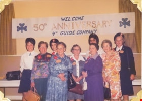
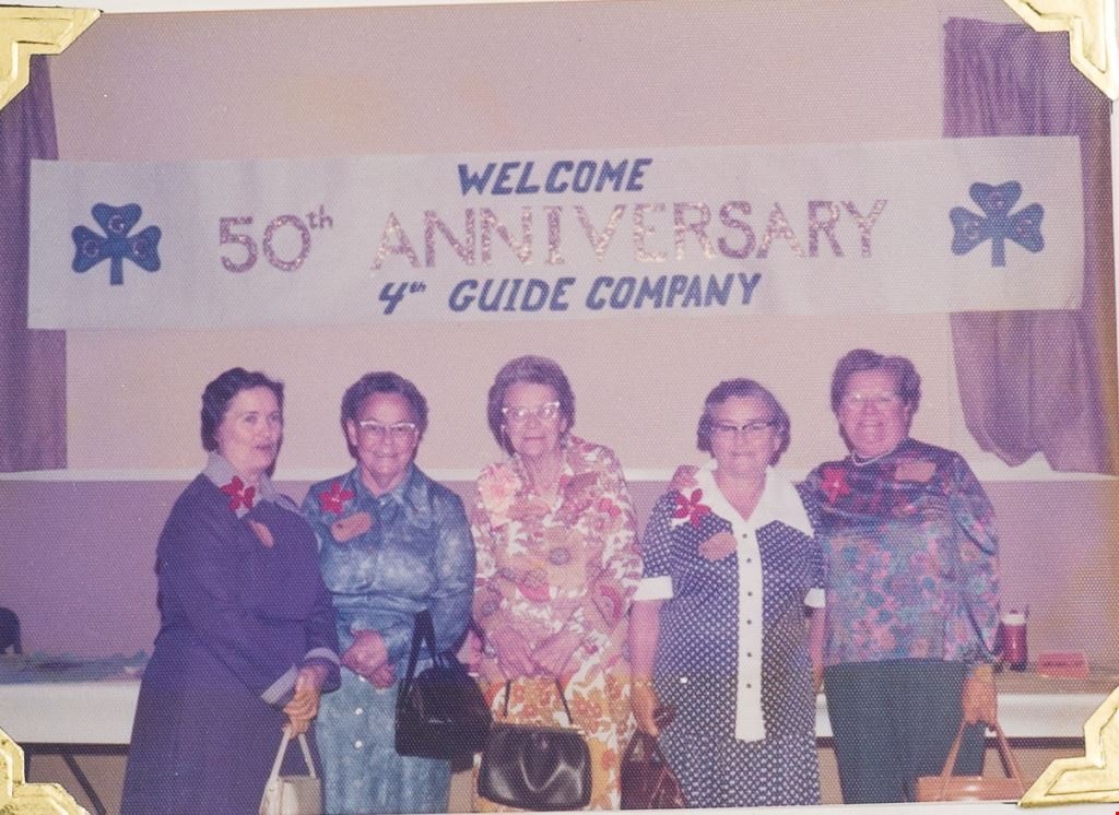
50th Anniversary 4th Guide Company
https://search.heritageburnaby.ca/link/museumdescription4949
- Repository
- Burnaby Village Museum
- Date
- Nov 3, 1976
- Collection/Fonds
- Burnaby Girl Guides fonds
- Description Level
- Item
- Physical Description
- 1 photograph : col. 9 x 12.5 cm
- Scope and Content
- Photograph of members of 4th Guide Company standing in front of a sign which reads "Welcome / 50th Anniversary / 4th Guide Company". Guiders in back row are identified from L to R as: Mrs. Dumka (Lt.), Mrs. Florence Underhill (Div. Comm.), Mrs. Kent (Dist. Comm), Mrs. Vivian E.S. Henderson (Area Co…
- Repository
- Burnaby Village Museum
- Collection/Fonds
- Burnaby Girl Guides fonds
- Description Level
- Item
- Physical Description
- 1 photograph : col. 9 x 12.5 cm
- Scope and Content
- Photograph of members of 4th Guide Company standing in front of a sign which reads "Welcome / 50th Anniversary / 4th Guide Company". Guiders in back row are identified from L to R as: Mrs. Dumka (Lt.), Mrs. Florence Underhill (Div. Comm.), Mrs. Kent (Dist. Comm), Mrs. Vivian E.S. Henderson (Area Comm.); Front row L to R: Mrs. Alice Thomas (Ellett), Mrs. Meta-Fay Miskell (Peden), Miss May Kelly, Miss Bessie Kelly, Mrs. Bristow (original guide captain).
- Other Title Information
- Title based on contents of photograph.
- Names
- Bristow, Dorothy
- Kent, Dorothy
- Kelly, May
- Kelly, Bessie
- Underhill, Florence
- Thomas, Alice Ellett
- Miskell, Meta Fay Peden
- Henderson, Vivian
- Girl Guides of Canada
- Accession Code
- BV015.35.285
- Access Restriction
- No restrictions
- Reproduction Restriction
- May be restricted by third party rights
- Date
- Nov 3, 1976
- Media Type
- Photograph
- Scan Resolution
- 600
- Scan Date
- 05/11/2018
- Notes
- Photograph is part of scrapbook BV015.35.166
Images

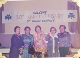
50th Anniversary 4th Guide Company
https://search.heritageburnaby.ca/link/museumdescription4950
- Repository
- Burnaby Village Museum
- Date
- Nov 3, 1976
- Collection/Fonds
- Burnaby Girl Guides fonds
- Description Level
- Item
- Physical Description
- 1 photograph : col. 9 x 12.5 cm
- Scope and Content
- Photograph of members of 4th Guide Company standing in front of a sign which reads "Welcome / 50th Anniversary / 4th Guide Company". Guiders are identified as: Center--Mrs. Bristow (original guide captain). L to R: Miss Bessie Kelly, Mrs. Meta-Fay Miskell (Peden), Miss May Kelly, Mrs. Alice Thomas…
- Repository
- Burnaby Village Museum
- Collection/Fonds
- Burnaby Girl Guides fonds
- Description Level
- Item
- Physical Description
- 1 photograph : col. 9 x 12.5 cm
- Scope and Content
- Photograph of members of 4th Guide Company standing in front of a sign which reads "Welcome / 50th Anniversary / 4th Guide Company". Guiders are identified as: Center--Mrs. Bristow (original guide captain). L to R: Miss Bessie Kelly, Mrs. Meta-Fay Miskell (Peden), Miss May Kelly, Mrs. Alice Thomas (Ellett). "These Ladies were guides with the original company".
- Other Title Information
- Title based on contents of photograph
- Names
- Bristow, Dorothy
- Kent, Dorothy
- Kelly, May
- Kelly, Bessie
- Underhill, Florence
- Thomas, Alice Ellett
- Miskell, Meta Fay Peden
- Henderson, Vivian
- Girl Guides of Canada
- Accession Code
- BV015.35.286
- Access Restriction
- No restrictions
- Reproduction Restriction
- May be restricted by third party rights
- Date
- Nov 3, 1976
- Media Type
- Photograph
- Scan Resolution
- 600
- Scan Date
- 05/11/2018
- Notes
- Photograph is part of scrapbook BV015.35.166
Images

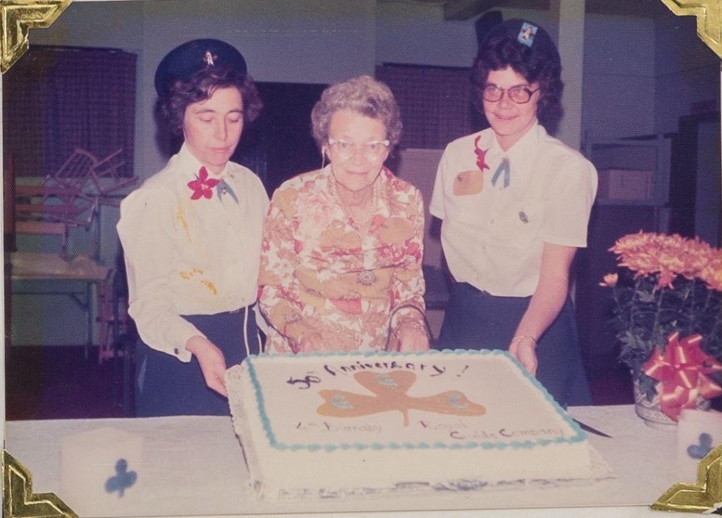
50th Anniversary 4th Guide Company cake
https://search.heritageburnaby.ca/link/museumdescription4951
- Repository
- Burnaby Village Museum
- Date
- Nov 3, 1976
- Collection/Fonds
- Burnaby Girl Guides fonds
- Description Level
- Item
- Physical Description
- 1 photograph : col. 9 x 12.5 cm
- Scope and Content
- Photograph of members of 4th Guide Company standing with a cake which reads "50th Anniversary / 4th Burnaby Royal Guide Company". Guiders are identified L to R Miss Jean Simmons, Mrs. Dorothy Bristow (original guide leader), Mrs. Ann Kent.
- Repository
- Burnaby Village Museum
- Collection/Fonds
- Burnaby Girl Guides fonds
- Description Level
- Item
- Physical Description
- 1 photograph : col. 9 x 12.5 cm
- Scope and Content
- Photograph of members of 4th Guide Company standing with a cake which reads "50th Anniversary / 4th Burnaby Royal Guide Company". Guiders are identified L to R Miss Jean Simmons, Mrs. Dorothy Bristow (original guide leader), Mrs. Ann Kent.
- Other Title Information
- Title based on contents of photograph
- Accession Code
- BV015.35.287
- Access Restriction
- No restrictions
- Reproduction Restriction
- May be restricted by third party rights
- Date
- Nov 3, 1976
- Media Type
- Photograph
- Scan Resolution
- 600
- Scan Date
- 05/11/2018
- Notes
- Photograph is part of scrapbook BV015.35.166
Images
![50th Anniversary G.G.C., [1926-1979] thumbnail](/media/hpo/_Data/_BVM_Images/2015/2015_0035_0166_folded_redacted.jpg?width=280)
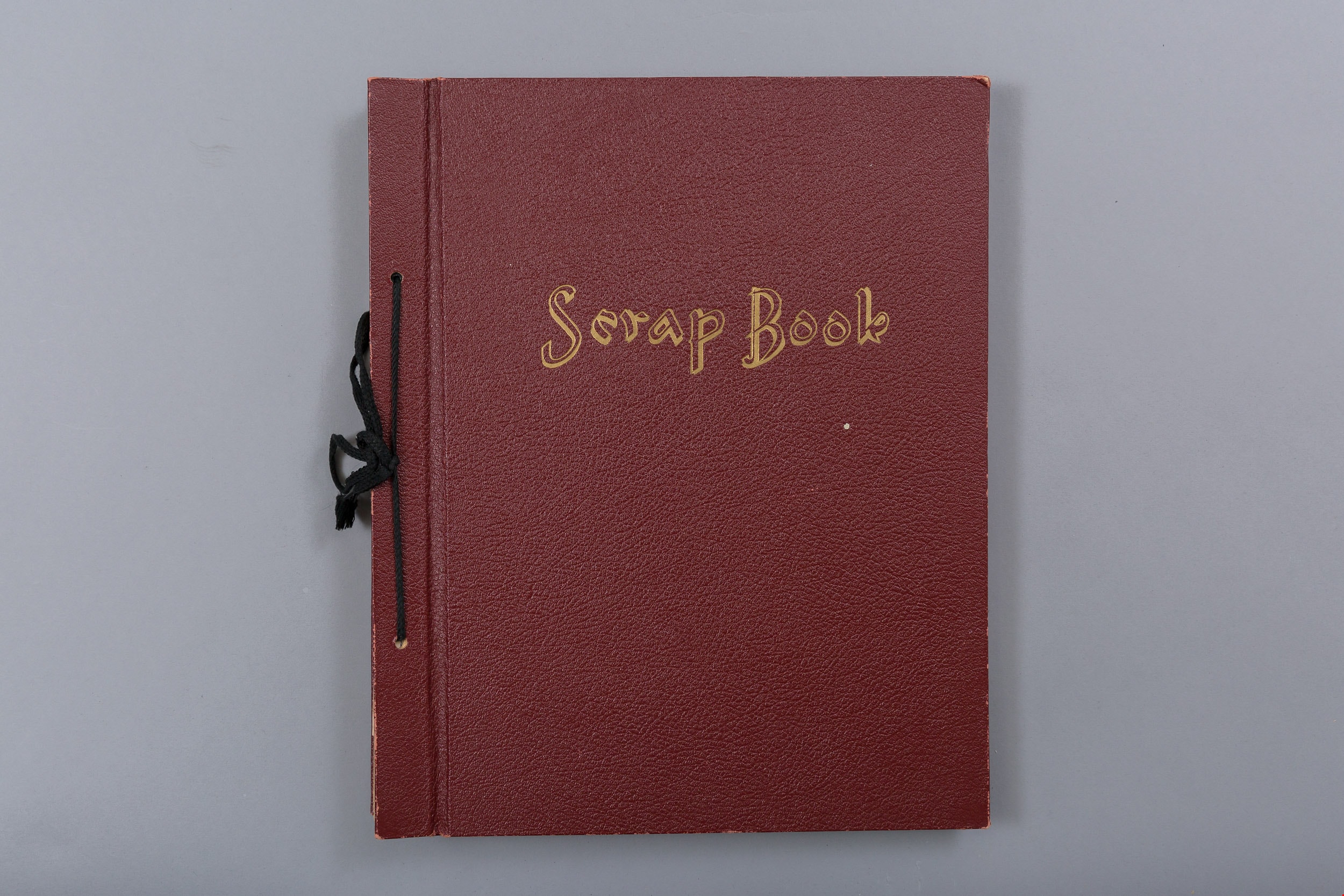
50th Anniversary G.G.C.
https://search.heritageburnaby.ca/link/museumdescription4594
- Repository
- Burnaby Village Museum
- Date
- [1926-1979]
- Collection/Fonds
- Burnaby Girl Guides fonds
- Description Level
- File
- Physical Description
- 1 scrapbook (51 photographs + 1 postcard + textual records)
- Scope and Content
- File consists of a scrapbook with a handpainted wood cover titled "50th Anniversary / G.G.C". The scrapbook documents events and ceremonies of the 4th Guide Company with the first half of the scrapbook containing photographs and documents regarding the 50th Anniversary of Girl Guides which was cele…
- Repository
- Burnaby Village Museum
- Collection/Fonds
- Burnaby Girl Guides fonds
- Description Level
- File
- Physical Description
- 1 scrapbook (51 photographs + 1 postcard + textual records)
- Scope and Content
- File consists of a scrapbook with a handpainted wood cover titled "50th Anniversary / G.G.C". The scrapbook documents events and ceremonies of the 4th Guide Company with the first half of the scrapbook containing photographs and documents regarding the 50th Anniversary of Girl Guides which was celebrated at St. Nicholas Church in 1960 while the second half documents earlier events from 1926, as well as other events in the 1960s such as; "Year of the Golden Jubilee", a parade in North Burnaby as well as Thinking Day 1976-1978, banquets, a disco contest, camping on Hollyburn mountain and a visit to Victoria in 1979. On November 3rd, 1926 the company was registered as the 5th Burnaby Guide company, in 1951 the number was changed to the 4th Vancouver Guide Company and in 1956 the number was changed to the 4th Burnaby Company.
- Accession Code
- BV015.35.166
- Access Restriction
- No restrictions
- Reproduction Restriction
- May be restricted by third party rights
- Date
- [1926-1979]
- Media Type
- Textual Record
- Photograph
- Notes
- Transcribed title
- Items within scrapbook have been redacted in compliance with Section 22 of FIPPA
- A selection of photographs are described at item level (BV015.35.285 to BV.015.35.300).
Images
![50th Anniversary G.G.C., [1926-1979] thumbnail](/media/hpo/_Data/_BVM_Images/2015/2015_0035_0166_folded_redacted.jpg)
Documents
51st Burnaby Pack C.W.L.
https://search.heritageburnaby.ca/link/museumdescription4582
- Repository
- Burnaby Village Museum
- Date
- 1967-1975
- Collection/Fonds
- Burnaby Girl Guides fonds
- Description Level
- File
- Physical Description
- 1 scrapbook (77 photographs + textual records + ephemera)
- Scope and Content
- File consists of a ninety-three page scrapbook containing photographs, original artwork, newspaper clippings and memorabilia for the 51st Burnaby Brownie Pack, C.W.L.; 1967 - 1975. The title page "51st Burnaby Pack / C.W.L. / 1967 - 1975" of the scrapbook includes a pen and coloured pencil illustra…
- Repository
- Burnaby Village Museum
- Collection/Fonds
- Burnaby Girl Guides fonds
- Description Level
- File
- Physical Description
- 1 scrapbook (77 photographs + textual records + ephemera)
- Scope and Content
- File consists of a ninety-three page scrapbook containing photographs, original artwork, newspaper clippings and memorabilia for the 51st Burnaby Brownie Pack, C.W.L.; 1967 - 1975. The title page "51st Burnaby Pack / C.W.L. / 1967 - 1975" of the scrapbook includes a pen and coloured pencil illustration with an owl on a toadstool surrounded by sprites, elves and fairies. Special events are documented with photographs, newspaper clippings, newsletters, collages, illustrations and a variety of ephemera pertaining to: Enrolment Ceremonies; various donations of handicrafts; service projects; Dedication Ceremonies of the International Peace Arch; camping; Brownie and Guide Revels at James Cowan Centre, Burnaby and Queen's Park, New Westminster; Jubilee Poetry Contest for Eastburn District; Ceremony for Mrs. Clysdale; Baden Powell Day; and winning Cookie sale posters. The 51st Brownie Pack was opened on September 23, 1967 with one Brownie and 18 tweenies. Mrs. Jeanne Schneider was acting Tawny Owl and Mrs. Terry Parkin acting Brown Owl. The 51st Brownie Pack was part of the Eastburn District, Imperial Division and regular meetings were held at Our Lady of Mercy School auditorium.
- Creator
- Parker, Terry
- Accession Code
- BV016.49.81
- Access Restriction
- No restrictions
- Reproduction Restriction
- May be restricted by third party rights
- Date
- 1967-1975
- Media Type
- Textual Record
- Photograph
- Notes
- Transcribed title
- Items online within scrapbook have been redacted in compliance with Section 22 of FIPPA
- Selected photographs from scrapbook are described at item level: BV016.49.100 to BV016.49.106
Images
Documents

123 Cinema sign
https://search.heritageburnaby.ca/link/archivedescription46283
- Repository
- City of Burnaby Archives
- Date
- November 15, 1979
- Collection/Fonds
- Columbian Newspaper collection
- Description Level
- Item
- Physical Description
- 1 photograph : b&w ; 24 x 9.5 cm
- Scope and Content
- Photograph of the 123 Cinema sign at Lougheed Mall which reads; "VOTE NOV 17 / DAVE MERCIER BVA / MAYOR".
- Repository
- City of Burnaby Archives
- Date
- November 15, 1979
- Collection/Fonds
- Columbian Newspaper collection
- Physical Description
- 1 photograph : b&w ; 24 x 9.5 cm
- Description Level
- Item
- Record No.
- 480-1171
- Access Restriction
- No restrictions
- Reproduction Restriction
- Reproduce for fair dealing purposes only
- Accession Number
- 2003-02
- Scope and Content
- Photograph of the 123 Cinema sign at Lougheed Mall which reads; "VOTE NOV 17 / DAVE MERCIER BVA / MAYOR".
- Names
- Lougheed Town Centre
- Media Type
- Photograph
- Photographer
- Hodge, Craig
- Notes
- Title based on contents of photograph
- Newspaper clipping attached to verso of photograph reads: "Now showing: Strong support for Mercier."
- Geographic Access
- Austin Road
- Historic Neighbourhood
- Burquitlam (Historic Neighbourhood)
- Planning Study Area
- Cameron Area
Images

![300 block of Esmonds, [between 1965 and 1970] thumbnail](/media/hpo/_Data/_Archives_Images/_Unrestricted/316/366-017.jpg?width=280)
300 block of Esmonds
https://search.heritageburnaby.ca/link/archivedescription37388
- Repository
- City of Burnaby Archives
- Date
- [between 1965 and 1970]
- Collection/Fonds
- Burnaby Historical Society fonds
- Description Level
- Item
- Physical Description
- 1 photograph : b&w negative
- Scope and Content
- Photograph taken looking south along the 300 block of Esmonds Avenue.
- Repository
- City of Burnaby Archives
- Date
- [between 1965 and 1970]
- Collection/Fonds
- Burnaby Historical Society fonds
- Subseries
- Municipal record subseries
- Physical Description
- 1 photograph : b&w negative
- Description Level
- Item
- Record No.
- 366-017
- Access Restriction
- No restrictions
- Reproduction Restriction
- Reproduce for fair dealing purposes only
- Accession Number
- BHS1998-12
- Scope and Content
- Photograph taken looking south along the 300 block of Esmonds Avenue.
- Subjects
- Geographic Features - Roads
- Media Type
- Photograph
- Notes
- Title based on contents of photograph
- Geographic Access
- Esmond Avenue
- Historic Neighbourhood
- Vancouver Heights (Historic Neighbourhood)
- Planning Study Area
- Burnaby Heights Area
Images
![300 block of Esmonds, [between 1965 and 1970] thumbnail](/media/hpo/_Data/_Archives_Images/_Unrestricted/316/366-017.jpg)

1930 Ford
https://search.heritageburnaby.ca/link/archivedescription79492
- Repository
- City of Burnaby Archives
- Date
- September 24, 1976
- Collection/Fonds
- Burnaby Public Library Contemporary Visual Archive Project
- Description Level
- Item
- Physical Description
- 1 photograph : b&w ; 11 x 16 cm mounted on cardboard
- Scope and Content
- Photograph shows a 1930 Ford car parked in the driveway of 6675 Eagles Drive.
- Repository
- City of Burnaby Archives
- Date
- September 24, 1976
- Collection/Fonds
- Burnaby Public Library Contemporary Visual Archive Project
- Physical Description
- 1 photograph : b&w ; 11 x 16 cm mounted on cardboard
- Description Level
- Item
- Record No.
- 556-323
- Access Restriction
- No restrictions
- Reproduction Restriction
- Reproduce for fair dealing purposes only
- Accession Number
- 2013-13
- Scope and Content
- Photograph shows a 1930 Ford car parked in the driveway of 6675 Eagles Drive.
- Subjects
- Transportation - Automobiles
- Media Type
- Photograph
- Photographer
- Norton, Paul
- Notes
- Scope note taken directly from BPL photograph description.
- 1 b&w copy negative : 10 x 12.5 cm accompanying
- Geographic Access
- Eagles Drive
- Street Address
- 6675 Eagles Drive
- Historic Neighbourhood
- Burnaby Lake (Historic Neighbourhood)
- Planning Study Area
- Morley-Buckingham Area
Images


1947 Chrysler
https://search.heritageburnaby.ca/link/archivedescription79488
- Repository
- City of Burnaby Archives
- Date
- November 4, 1976
- Collection/Fonds
- Burnaby Public Library Contemporary Visual Archive Project
- Description Level
- Item
- Physical Description
- 1 photograph : b&w ; 11 x 16 cm mounted on cardboard
- Scope and Content
- Photograph shows a 1947 Chrysler parked next to driveway at 3708 Cardiff Street.
- Repository
- City of Burnaby Archives
- Date
- November 4, 1976
- Collection/Fonds
- Burnaby Public Library Contemporary Visual Archive Project
- Physical Description
- 1 photograph : b&w ; 11 x 16 cm mounted on cardboard
- Description Level
- Item
- Record No.
- 556-320
- Access Restriction
- No restrictions
- Reproduction Restriction
- Reproduce for fair dealing purposes only
- Accession Number
- 2013-13
- Scope and Content
- Photograph shows a 1947 Chrysler parked next to driveway at 3708 Cardiff Street.
- Subjects
- Transportation - Automobiles
- Media Type
- Photograph
- Photographer
- Norton, Paul
- Notes
- Scope note taken directly from BPL photograph description.
- 1 b&w copy negative : 10 x 12.5 cm accompanying
- Geographic Access
- Cardiff Street
- Street Address
- 3708 Cardiff Street
- Historic Neighbourhood
- Central Park (Historic Neighbourhood)
- Planning Study Area
- Garden Village Area
Images

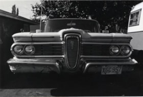
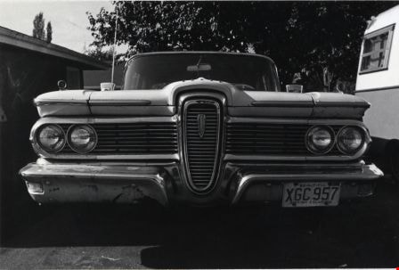
1959 Ford Edsel
https://search.heritageburnaby.ca/link/archivedescription79490
- Repository
- City of Burnaby Archives
- Date
- October 14, 1976
- Collection/Fonds
- Burnaby Public Library Contemporary Visual Archive Project
- Description Level
- Item
- Physical Description
- 1 photograph : b&w ; 11 x 16 cm mounted on cardboard
- Scope and Content
- Photograph shows a 1959 Ford Edsel parked in the 4300 block Fir Street.
- Repository
- City of Burnaby Archives
- Date
- October 14, 1976
- Collection/Fonds
- Burnaby Public Library Contemporary Visual Archive Project
- Physical Description
- 1 photograph : b&w ; 11 x 16 cm mounted on cardboard
- Description Level
- Item
- Record No.
- 556-321
- Access Restriction
- No restrictions
- Reproduction Restriction
- Reproduce for fair dealing purposes only
- Accession Number
- 2013-13
- Scope and Content
- Photograph shows a 1959 Ford Edsel parked in the 4300 block Fir Street.
- Subjects
- Transportation - Automobiles
- Media Type
- Photograph
- Photographer
- Norton, Paul
- Notes
- Scope note taken directly from BPL photograph description.
- 1 b&w copy negative : 10 x 12.5 cm accompanying
- Geographic Access
- Fir Street
- Street Address
- 4300 Fir Street
- Planning Study Area
- Cascade-Schou Area
Images

1964 Ford Meteor
https://search.heritageburnaby.ca/link/archivedescription79493
- Repository
- City of Burnaby Archives
- Date
- September 16, 1976
- Collection/Fonds
- Burnaby Public Library Contemporary Visual Archive Project
- Description Level
- Item
- Physical Description
- 1 photograph : b&w ; 11 x 16 cm mounted on cardboard
- Scope and Content
- Photograph shows a 1964 Ford Meteor convertible parked outside the house at 943 Sperling Avenue.
- Repository
- City of Burnaby Archives
- Date
- September 16, 1976
- Collection/Fonds
- Burnaby Public Library Contemporary Visual Archive Project
- Physical Description
- 1 photograph : b&w ; 11 x 16 cm mounted on cardboard
- Description Level
- Item
- Record No.
- 556-324
- Access Restriction
- No restrictions
- Reproduction Restriction
- Reproduce for fair dealing purposes only
- Accession Number
- 2013-13
- Scope and Content
- Photograph shows a 1964 Ford Meteor convertible parked outside the house at 943 Sperling Avenue.
- Subjects
- Transportation - Automobiles
- Media Type
- Photograph
- Photographer
- Born, A. J.
- Notes
- Scope note taken directly from BPL photograph description.
- 1 b&w copy negative : 10 x 12.5 cm accompanying
- Geographic Access
- Sperling Avenue
- Street Address
- 943 Sperling Avenue
- Historic Neighbourhood
- Lochdale (Historic Neighbourhood)
- Planning Study Area
- Lochdale Area
Images
