Narrow Results By
Format
- Architectural Drawing 157
- Book 393
- Bylaws - Adopted 2087
- Bylaws - Other 1
- Bylaws - Repealed 198
- Cartographic Material 51
- Council - Committee Report 2035
- Council - Manager's Report 9339
- Council - Mayor/Councillor/Staff Report 2958
- Council - Public Hearing Minutes 120
- Council - Regular Council Minutes 1060
- Graphic Material 17
Subject
- Accidents 7
- Accidents - Automobile Accidents 6
- Accidents - Train Accidents 14
- Adminstrative Groups - Committees 4
- Adornment - Jewelry 1
- Advertising Medium 1
- Advertising Medium - Flyer 3
- Advertising Medium - Poster 15
- Advertising Medium - Signs and Signboards 91
- Aerial Photographs 48
- Agricultural Tools and Equipment 2
- Agricultural Tools and Equipment - Gardening Equipment 3
![William Arthur Crute, [1971] thumbnail](/media/hpo/_Data/_BVM_Images/2020/2020_0005_1662_001.jpg?width=280)
William Arthur Crute
https://search.heritageburnaby.ca/link/museumdescription15313
- Repository
- Burnaby Village Museum
- Date
- [1971]
- Collection/Fonds
- Century Park Museum Association fonds
- Description Level
- Item
- Physical Description
- 1 photograph : b&w ; 9 x 12.5 cm
- Scope and Content
- Photograph of William Arthur Crute dressed in a black hat, tie and overcoat. Arthur Crute is seated in a wheelchair on the site the Heritage Village during the opening ceremonies in November 1971.
- Repository
- Burnaby Village Museum
- Collection/Fonds
- Century Park Museum Association fonds
- Description Level
- Item
- Physical Description
- 1 photograph : b&w ; 9 x 12.5 cm
- Scope and Content
- Photograph of William Arthur Crute dressed in a black hat, tie and overcoat. Arthur Crute is seated in a wheelchair on the site the Heritage Village during the opening ceremonies in November 1971.
- History
- William Arthur Crute (1889-1977) was trained as a carpenter and worked alongside William Dodson on the interior carpentry construction of the Bateman family house "Elworth". The heritage house now forms part of the Burnaby Village Museum. Arthur Crute was present for the opening of Heritage Village (now Burnaby Village Museum) in November 1971.
- Names
- Crute, William "Arthur"
- Accession Code
- BV020.5.1662
- Access Restriction
- No restrictions
- Reproduction Restriction
- May be restricted by third party rights
- Date
- [1971]
- Media Type
- Photograph
- Scan Resolution
- 600
- Scan Date
- March 17, 2021
- Scale
- 100
- Notes
- Title based on contents of photograph
- Note in black ink on verso of photograph reads: "Mr. Arthur (Art) Crute Carpenter "Elworth".
- Information gathered from Century Park / Heritage Village Newsletter article "Heritage Village's Restored Country Home"
Images
![William Arthur Crute, [1971] thumbnail](/media/hpo/_Data/_BVM_Images/2020/2020_0005_1662_001.jpg)
William Harold Carr fonds
https://search.heritageburnaby.ca/link/museumdescription10136
- Repository
- Burnaby Village Museum
- Date
- 1977
- Collection/Fonds
- William Harold Carr fonds
- Description Level
- Fonds
- Physical Description
- 1 album (ca. 28 photographs)
- Scope and Content
- Fonds consists of a thirty three page photograph album documenting the building of an outhouse by Century Park Museum Association volunteer, Harold Carr on the site of Heritage Village in Century Park (Burnaby Village Museum). The album is titled: "THE EPIC OF THE / OUTHOUSE / The Only (Privy) Bif…
- Repository
- Burnaby Village Museum
- Collection/Fonds
- William Harold Carr fonds
- Description Level
- Fonds
- Physical Description
- 1 album (ca. 28 photographs)
- Material Details
- Pages include typewritten text pasted below each photograph
- Scope and Content
- Fonds consists of a thirty three page photograph album documenting the building of an outhouse by Century Park Museum Association volunteer, Harold Carr on the site of Heritage Village in Century Park (Burnaby Village Museum). The album is titled: "THE EPIC OF THE / OUTHOUSE / The Only (Privy) Biffy in Heritage Village with the Good Housekeeping / Seal of disApproval, 1977" / "Built by Mr. W. H. Carr / Privy Councillor / and Builder Emeritus". Photography by R. S. Banford & M. Smith, Marbo Photographics, North Vancouver."
- History
- William Harold Carr was the son of Mr. and Mrs. Joseph Carr of Vancouver. He and his twin brother, James Allen Carr, were born in Edmonton on June 18, 1917. Harold moved to Burnaby with his family (including his sisters, Muriel and Maisie) in 1924. His parents bought a lot in District Lot 94 and built a house at 3119 Royal Oak, (after 1958: 6270 Royal Oak Ave.). After World War II, Harold married Daphne Adel Withers on April 13, 1946 at Christ Church Cathedral in Vancouver. In 1946, the couple built a house at 2836 Pearl Avenue (Address after 1958: 6269 Pearl Ave.). The house was built on a portion of District Lot 94 that faced Pearl Street and was owned by Harold’s parents, Mr. and Mrs. Joseph Carr. Harold and Daphne had one child named Warren. Harold worked as an engineer for the CPR and prior to this he worked at Mohawk Lumber. Harold and his wife Daphne became involved with the Century Park Museum Association in the mid-1970s. Daphne volunteered to run the gift shop while Harold volunteered as an engineer on the model railway. Besides working on the model railway in Heritage Village, Harold also built a chicken coup and the outhouse located near Tom Irvine’s house. Harold died in 1981 at the age of 64 years, just one year prior to his retirement at CPR.
- Creator
- Carr, William Harold
- Accession Code
- BV011.59
- Access Restriction
- No restrictions
- Reproduction Restriction
- May be restricted by third party rights
- Date
- 1977
- Media Type
- Textual Record
- Photograph
- Arrangement
- Photograph album and photographs within are described at item level
- Notes
- Tilte based on contents of fonds
William H. Burke
https://search.heritageburnaby.ca/link/archivedescription45134
- Repository
- City of Burnaby Archives
- Date
- 1972
- Collection/Fonds
- Columbian Newspaper collection
- Description Level
- Item
- Physical Description
- 1 photograph : b&w ; 14.5 x 10 cm
- Scope and Content
- Photograph of William H. Burke, a BC Hydro Armoured Car Attendant. He had been a Burnaby School Trustee for six years when he used this photograph in his election campaign to become re-elected.
- Repository
- City of Burnaby Archives
- Date
- 1972
- Collection/Fonds
- Columbian Newspaper collection
- Physical Description
- 1 photograph : b&w ; 14.5 x 10 cm
- Description Level
- Item
- Record No.
- 480-030
- Access Restriction
- No restrictions
- Reproduction Restriction
- Reproduce for fair dealing purposes only
- Accession Number
- 2003-02
- Scope and Content
- Photograph of William H. Burke, a BC Hydro Armoured Car Attendant. He had been a Burnaby School Trustee for six years when he used this photograph in his election campaign to become re-elected.
- Subjects
- Officials - Elected Officials
- Names
- Burnaby School Trustees
- Media Type
- Photograph
- Photographer
- Burnaby Photographers
- Notes
- Title based on contents of photograph
William Holmes fonds
https://search.heritageburnaby.ca/link/museumdescription10416
- Repository
- Burnaby Village Museum
- Date
- [1841]-1994
- Collection/Fonds
- William Holmes fonds
- Description Level
- Fonds
- Physical Description
- 2 photographs (calotype) + 1 photograph : b&w + 6 photographs : col. + 5 p. textual records + 1 newspaper clipping
- Scope and Content
- Fonds consists of photographs pertaining to the William Holmes family, family grave markers in cemetery in Ireland along with original correspondence, land title certificates and a newspaper clipping. Fonds is arranged in series: 1) William Holmes family photographs series 2) William Holmes family…
- Repository
- Burnaby Village Museum
- Collection/Fonds
- William Holmes fonds
- Description Level
- Fonds
- Physical Description
- 2 photographs (calotype) + 1 photograph : b&w + 6 photographs : col. + 5 p. textual records + 1 newspaper clipping
- Scope and Content
- Fonds consists of photographs pertaining to the William Holmes family, family grave markers in cemetery in Ireland along with original correspondence, land title certificates and a newspaper clipping. Fonds is arranged in series: 1) William Holmes family photographs series 2) William Holmes family records series 3) Holmes family cemetery photographs series
- History
- William Holmes was the first non-Indigenous resident of Burnaby and was born in Kilkenny Ireland January 4, 1812. In 1833, at the age of 20 yrs, William Holmes immigrated to Canada from Ireland in with his parents, Joseph and Jane (McCullough) Holmes and ten other family members including two of his married brothers and their wives, two sisters with their husbands and two unmarried brothers. This was the first group of thirteen to leave Ireland and set up homesteads in Canada near the shores of Lake Huron. The family settled on land concessions in Huron County, Ontario about 14 km southeast of Goderich. The area in Huron County was first founded in 1832 by John and Samuel Holmes and the community was known as Holmes Hill before becoming Holmesville [ca. 1850]. In 1837, William Holmes is noted as owning Lot 23, Concession IX, Goderich Twp. Much of the village of Holmesville grew up around the five road concession near the border of his brother’s farm so William decided to open a store. The Holmesville post office opened on March 1, 1855 and William was appointed the first post master which he operated until May 1857. William met and married Mary Richardson in 1841 and the couple had three daughters: Jane (1844-1926) (married Charles Studdert Finlaison in New Westminster in 1863); Anne Maria (Annie) (1846-192?) (married John Gunther Jennings in New Westminster in 1865 and married Robert Johnson in New Westminster in 1877) and Elizabeth (1848-1934) (married Thomas Carrington of Lakes District in 1867). William’s wife, Mary (Richardson) Holmes died in Holmesville sometime between 1848 and 1853. Following the death of his first wife, Mary, William married Charlotte McCullough (McCulloch). The couple had four daughters; Arabella Charlotte Amelia (1854-1943) (married Arthur Robert Green in 1887); Laura (1855-1867); Arabella Henrietta (1857-1929) (married Clark Wesley Gillanders in 1880) and Mary (1863-1864). During the late 1850s, William became aware of the gold rush and opportunities opening up in British Columbia so left for the west coast in 1858 at the age of 46 yrs. In preparation for his move to the west coast of Canada, William obtained a letter of introduction from top government officials of Canada. William Holmes arrived in British Columbia in 1859. Upon arriving, he first worked running pack trains from Harrison Mills to Lillooet. After earning some money, he decided to re-invest it in land. His first pre-emption of land occurred on January 21, 1860 for 160 acres situated on North Road from the Military Camp to Burrard Inlet and distancing 25 chains south of the Brunette River and 20 chains south of the river with the land extending in a westerly direction. On March 17, 1860, Holmes received a Crown Grant for this and other land in the immediate area totalling 415 acres of which was known as Lot No. 1, Group 1, Rural Land, New Westminster District. The balance of land was situated on the east side of the Brunette River – Lot 13, with 344 2/3 acres of which he made an application to purchase on June 26, 1860, and a Crown Grant dated March 16, 1861 covering 86 acres. Holmes also pre-empted land in Port Moody and Pitt Meadows in 1860 and 1861. The name of “Brunette River” is officially attributed to William Holmes who referred to the river as “Brunette” due to it’s dark colour originating from the peat lands above the lake. Following his purchase of property, he sent for his wife Charlotte, their three daughters and her three step daughters (from William’s first marriage). Charlotte and the six children made the long trip to B.C. by ship and rail, crossing the Isthmus of Darien at Panama. They arrived in B.C. in October 1861 and moved into a one room log cabin built by William. The cabin stood on the North Road at the foot of Sapperton, on a bluff overlooking the Brunette River. Eventually the family moved to a larger dwelling but the original cabin remained on the site until the 1890s when it was burned after being used as a sick house. Mr. Holmes was instrumental in organizing the first Orange Lodge in British Columbia. He was a prominent Orangeman who joined the order in 1840 and was the first master in the order of the City of New Westminster when the Lodge No. 1150 was established there. Charlotte Holmes died in New Westminster in 1893 at the age of 70 years and William Holmes died in New Westminster September 11, 1907 at the age of 95 years.
- Responsibility
- Holmes, William
- Accession Code
- HV971.46
- BV997.50
- Date
- [1841]-1994
- Media Type
- Photograph
- Textual Record
- Related Material
- See also: Reference file: Persons - Holmes, William
- Notes
- Title based on contents of fonds
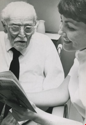
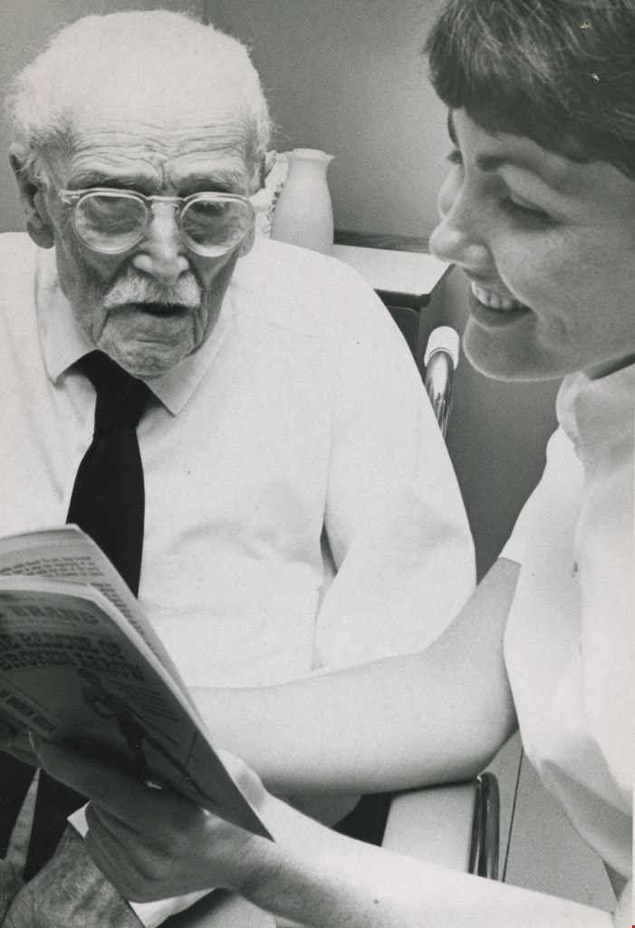
William Lindsay and Marion Wood
https://search.heritageburnaby.ca/link/archivedescription45937
- Repository
- City of Burnaby Archives
- Date
- 1970
- Collection/Fonds
- Columbian Newspaper collection
- Description Level
- Item
- Physical Description
- 1 photograph : b&w ; 20 x 14 cm
- Scope and Content
- Photograph of William Lindsay celebrating his 104th birthday with nursing aide Marion Wood, at the Felburn private hospital in Burnaby.
- Repository
- City of Burnaby Archives
- Date
- 1970
- Collection/Fonds
- Columbian Newspaper collection
- Physical Description
- 1 photograph : b&w ; 20 x 14 cm
- Description Level
- Item
- Record No.
- 480-831
- Access Restriction
- No restrictions
- Reproduction Restriction
- Reproduce for fair dealing purposes only
- Accession Number
- 2003-02
- Scope and Content
- Photograph of William Lindsay celebrating his 104th birthday with nursing aide Marion Wood, at the Felburn private hospital in Burnaby.
- Subjects
- Occupations - Nurses
- Celebrations
- Names
- Lindsay, William
- Wood, Marion
- Media Type
- Photograph
- Photographer
- Symonds, John
- Notes
- Title based on contents of photograph
- Geographic Access
- Hastings Street
- Street Address
- 6050 Hastings Street
- Planning Study Area
- Parkcrest-Aubrey Area
Images
William Martin family fonds
https://search.heritageburnaby.ca/link/archivedescription66694
- Repository
- City of Burnaby Archives
- Date
- 1927-1940 (date of originals)
- Collection/Fonds
- William Martin family fonds
- Description Level
- Fonds
- Physical Description
- 26 photographs : 1 original photograph + 19 jpegs + 6 copy prints
- Scope and Content
- Fonds consists of photographs of the William and Ellen Martin family, pioneers of Burnaby.
- Repository
- City of Burnaby Archives
- Date
- 1927-1940 (date of originals)
- Collection/Fonds
- William Martin family fonds
- Physical Description
- 26 photographs : 1 original photograph + 19 jpegs + 6 copy prints
- Material Details
- 2 copy prints + 1 jpeg are duplicates to the original; 3 copy prints are duplicates to a larger copy print
- Description Level
- Fonds
- Accession Number
- 2011-11
- 2006-03
- 2012-03
- Scope and Content
- Fonds consists of photographs of the William and Ellen Martin family, pioneers of Burnaby.
- History
- William Martin and Ellen Ward met while attending school in Glasgow, Scotland. They married in 1916 while William was on leave from the Canadian Over-Seas Expeditionary Force. After the war, they immigrated to Canada with their two-year-old daughter, Margaret. They spent a few years in Vancouver where three more daughters were born: Barbara (later Punnett); Juanita (later Safarik); and Sally (later Forbes). With their four small daughters, they moved to Los Angeles where William worked as a craftsman for Samuel Goldwyn Studios. In 1926, they returned to B.C., where William purchased five acres of land on Spruce Street in Burnaby. Much of the land had been logged but not cleared. Dynamite was used to remove the large, burnt stumps. While William prepared the land for a new house, the family lived in a temporary building that was later used for a garage. The seven-room house that William built was one of the first houses on Spruce Street. During this time, William and Ellen’s two sons, Bill and Jackie, were born. The Martins made good use of their property. They kept chickens, ducks, and a goat, planted fruit trees, and had a large raspberry patch. The children enjoyed their large playground, much of it still heavily forested. In the winter they walked to Deer Lake to ice skate. They hiked Burnaby Mountain and sometimes walked to Capitol Hill where there was a recreation centre. All six children attended Douglas Road School and South Burnaby Secondary School. Margaret became a schoolteacher; Juanita and Barbara did office work after attending Sprott Shaw Business School; Sally became a public health nurse; and Bill and Jackie became doctors. Margaret taught in Burnaby schools for 27 years. Before her marriage, Sally served as a public health nurse in Burnaby for three years. Bill had an ophthalmology practice in Burnaby until his retirement. Margaret married Jack Greenall, the eldest son of another Burnaby family who lived on Nursery Street on a large property with a garden, greenhouse, and chicken house. Margaret and Jack had three children: Dr. Martin Greenall, Sharon (later Ingalls), and Diane (later Macnair). Margaret later married Peter Andrusiak and had two sons: Gordon and Peter. All of her children were raised in New Westminster. Margaret was active in her community and was awarded the New Westminster Citizen of the Year award in 1992. She died July 26, 2006, at the age of 89.
- Formats
- Records from accession 2011-11 exist only in electronic format - copied 2011
- Media Type
- Photograph
- Creator
- Martin family
- Notes
- Title based on contents of fonds
- Photo catalogue 525
![William Parker with shovel, [between 1930 and 1940] (date of original), copied 1998 thumbnail](/media/hpo/_Data/_BVM_Images/2018/2018_0041_0169_001.jpg?width=280)
William Parker with shovel
https://search.heritageburnaby.ca/link/museumdescription9983
- Repository
- Burnaby Village Museum
- Date
- [between 1930 and 1940] (date of original), copied 1998
- Collection/Fonds
- Burnaby Village Museum fonds
- Description Level
- Item
- Physical Description
- 1 photograph : sepia print ; 13 x 9.5 cm
- Scope and Content
- Photograph of William Parker digging with a shovel on the grounds of the Love farmhouse. There is a barn and tree behind him. In 1928 after Sarah Parker's father, Jesse Love died, William and Sarah (nee Love) Parker purchased the Love farmhouse located at 1390 Cumberland Road. They lived there unt…
- Repository
- Burnaby Village Museum
- Collection/Fonds
- Burnaby Village Museum fonds
- Series
- Jesse Love farmhouse series
- Subseries
- Love family photographs subseries
- Description Level
- Item
- Physical Description
- 1 photograph : sepia print ; 13 x 9.5 cm
- Scope and Content
- Photograph of William Parker digging with a shovel on the grounds of the Love farmhouse. There is a barn and tree behind him. In 1928 after Sarah Parker's father, Jesse Love died, William and Sarah (nee Love) Parker purchased the Love farmhouse located at 1390 Cumberland Road. They lived there until 1961, with their three children; Albert, Bill and Elsie.
- Subjects
- Buildings - Heritage
- Geographic Access
- Cumberland Street
- Street Address
- 7651 Cumberland Street
- Accession Code
- BV018.41.169
- Access Restriction
- No restrictions
- Reproduction Restriction
- May be restricted by third party rights
- Date
- [between 1930 and 1940] (date of original), copied 1998
- Media Type
- Photograph
- Historic Neighbourhood
- East Burnaby (Historic Neighbourhood)
- Planning Study Area
- Cariboo-Armstrong Area
- Scan Resolution
- 600
- Scan Date
- 25-Feb-2019
- Scale
- 100
- Notes
- Title based on contents of photograph
- Photograph was copied from the Albert Parker photograph album in 1998
Images
![William Parker with shovel, [between 1930 and 1940] (date of original), copied 1998 thumbnail](/media/hpo/_Data/_BVM_Images/2018/2018_0041_0169_001.jpg)
William Randolph Beamish scrapbook
https://search.heritageburnaby.ca/link/archivedescription100654
- Repository
- City of Burnaby Archives
- Date
- 1861-2009
- Collection/Fonds
- William Randolph Beamish fonds
- Description Level
- Series
- Physical Description
- 3.5 cm. of textual records; 17 small b&w prints; 10 med. prints; and 6 large b&w prints.
- Scope and Content
- Series consists of records that were compiled into a binder as a scrapbook by Ilma Beamish Dunn, the adopted sister of William Randolph Beamish. Scope and content notes at the file- and item-level have been drawn from the thorough recordkeeping Dunn employed in creating the scrapbook.
- Repository
- City of Burnaby Archives
- Date
- 1861-2009
- Collection/Fonds
- William Randolph Beamish fonds
- Physical Description
- 3.5 cm. of textual records; 17 small b&w prints; 10 med. prints; and 6 large b&w prints.
- Description Level
- Series
- Record No.
- 66672
- Access Restriction
- No restrictions
- Accession Number
- 2023-03
- Scope and Content
- Series consists of records that were compiled into a binder as a scrapbook by Ilma Beamish Dunn, the adopted sister of William Randolph Beamish. Scope and content notes at the file- and item-level have been drawn from the thorough recordkeeping Dunn employed in creating the scrapbook.
- Media Type
- Textual Record
- Photograph

Williamson family home
https://search.heritageburnaby.ca/link/archivedescription35404
- Repository
- City of Burnaby Archives
- Date
- 1930 (date of original), copied 1986
- Collection/Fonds
- Burnaby Historical Society fonds
- Description Level
- Item
- Physical Description
- 1 photograph : b&w ; 12.7 x 17.8 cm print
- Scope and Content
- Photograph of the completed Williamson family home at 6965 Antrim Avenue. Pictured (left to right) Marjorie Williamson and Elsie Williamson, daughters of Mr. Williamson and Mrs. Minnie Williamson, who built the home.
- Repository
- City of Burnaby Archives
- Date
- 1930 (date of original), copied 1986
- Collection/Fonds
- Burnaby Historical Society fonds
- Subseries
- Pioneer Tales subseries
- Physical Description
- 1 photograph : b&w ; 12.7 x 17.8 cm print
- Description Level
- Item
- Record No.
- 204-261
- Access Restriction
- No restrictions
- Reproduction Restriction
- No known restrictions
- Accession Number
- BHS1988-03
- Scope and Content
- Photograph of the completed Williamson family home at 6965 Antrim Avenue. Pictured (left to right) Marjorie Williamson and Elsie Williamson, daughters of Mr. Williamson and Mrs. Minnie Williamson, who built the home.
- Subjects
- Toys - Dolls
- Media Type
- Photograph
- Notes
- Title based on contents of photograph
- Geographic Access
- Antrim Avenue
- Street Address
- 6965 Antrim Avenue
- Historic Neighbourhood
- Central Park (Historic Neighbourhood)
- Planning Study Area
- Windsor Area
Images

![William Toy with grandaughters, [197-] thumbnail](/media/hpo/_Data/_BVM_Images/2023/2023_0025_0011_001.jpg?width=280)
William Toy with grandaughters
https://search.heritageburnaby.ca/link/museumdescription20348
- Repository
- Burnaby Village Museum
- Date
- [197-]
- Collection/Fonds
- Harry Toy fonds
- Description Level
- Item
- Physical Description
- 1 photograph : col. ; 12.5 x 9 cm
- Scope and Content
- Photograph of William "Bill" Toy standing together with his grandaughters, Melinda, Beverley and Christina Toy in front of the Canada Way Food Market located at 4694 Canada Way, Burnaby.
- Repository
- Burnaby Village Museum
- Collection/Fonds
- Harry Toy fonds
- Series
- Harry Toy photographs series
- Description Level
- Item
- Physical Description
- 1 photograph : col. ; 12.5 x 9 cm
- Scope and Content
- Photograph of William "Bill" Toy standing together with his grandaughters, Melinda, Beverley and Christina Toy in front of the Canada Way Food Market located at 4694 Canada Way, Burnaby.
- Geographic Access
- Canada Way
- Street Address
- 4694 Canada Way
- Accession Code
- BV023.25.11
- Access Restriction
- No restrictions
- Reproduction Restriction
- No known restrictions
- Date
- [197-]
- Media Type
- Photograph
- Related Material
- See also BV023.16.19 - Interview with Harry Toy, Beverley Babey and Christina Toy
- For associated artifacts from Canada Way Food Market see Accession BV023.17
- Scan Resolution
- 600
- Scan Date
- 2023-12-01
- Notes
- Title based on contents of photograph
Images
![William Toy with grandaughters, [197-] thumbnail](/media/hpo/_Data/_BVM_Images/2023/2023_0025_0011_001.jpg)

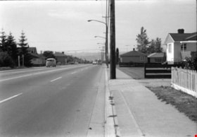
Willingdon Avenue
https://search.heritageburnaby.ca/link/archivedescription51632
- Repository
- City of Burnaby Archives
- Date
- 1970
- Collection/Fonds
- Harold H. Johnston fonds
- Description Level
- Item
- Physical Description
- 1 photograph (jpeg) : b&w
- Scope and Content
- Photograph taken looking north along Willingdon Avenue.
- Repository
- City of Burnaby Archives
- Date
- 1970
- Collection/Fonds
- Harold H. Johnston fonds
- Physical Description
- 1 photograph (jpeg) : b&w
- Description Level
- Item
- Record No.
- 483-079
- Access Restriction
- No restrictions
- Reproduction Restriction
- No reproduction permitted
- Accession Number
- 2008-08
- Scope and Content
- Photograph taken looking north along Willingdon Avenue.
- Subjects
- Geographic Features - Roads
- Media Type
- Photograph
- Photographer
- Johnston, Harold H.
- Notes
- Title based on contents of photograph
- Geographic Access
- Willingdon Avenue
- Historic Neighbourhood
- Vancouver Heights (Historic Neighbourhood)
- Planning Study Area
- Willingdon Heights Area
Images

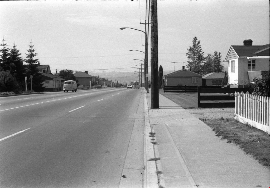
Willingdon Avenue
https://search.heritageburnaby.ca/link/archivedescription51636
- Repository
- City of Burnaby Archives
- Date
- 1970
- Collection/Fonds
- Harold H. Johnston fonds
- Description Level
- Item
- Physical Description
- 1 photograph (jpeg) : b&w
- Scope and Content
- Photograph taken looking south along Willingdon Avenue.
- Repository
- City of Burnaby Archives
- Date
- 1970
- Collection/Fonds
- Harold H. Johnston fonds
- Physical Description
- 1 photograph (jpeg) : b&w
- Description Level
- Item
- Record No.
- 483-080
- Access Restriction
- No restrictions
- Reproduction Restriction
- No reproduction permitted
- Accession Number
- 2008-08
- Scope and Content
- Photograph taken looking south along Willingdon Avenue.
- Subjects
- Geographic Features - Roads
- Media Type
- Photograph
- Photographer
- Johnston, Harold H.
- Notes
- Title based on contents of photograph
- Geographic Access
- Willingdon Avenue
- Historic Neighbourhood
- Vancouver Heights (Historic Neighbourhood)
- Planning Study Area
- Willingdon Heights Area
Images
Willingdon Heights Community Church
https://search.heritageburnaby.ca/link/archivedescription79046
- Repository
- City of Burnaby Archives
- Date
- October, 1976
- Collection/Fonds
- Burnaby Public Library Contemporary Visual Archive Project
- Description Level
- Item
- Physical Description
- 1 photograph : b&w ; 11 x 16 cm mounted on cardboard
- Scope and Content
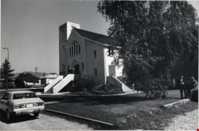
- Photograph shows the Willingdon Heights Community Church, built in 1952, at 4304 Parker Street, on the corner of Parker Street and Madison Avenue. The Rev. Ward and a few members of the congregation are pictured.
- Repository
- City of Burnaby Archives
- Date
- October, 1976
- Collection/Fonds
- Burnaby Public Library Contemporary Visual Archive Project
- Physical Description
- 1 photograph : b&w ; 11 x 16 cm mounted on cardboard
- Description Level
- Item
- Record No.
- 556-113
- Access Restriction
- No restrictions
- Reproduction Restriction
- Reproduce for fair dealing purposes only
- Accession Number
- 2013-13
- Scope and Content
- Photograph shows the Willingdon Heights Community Church, built in 1952, at 4304 Parker Street, on the corner of Parker Street and Madison Avenue. The Rev. Ward and a few members of the congregation are pictured.
- Subjects
- Buildings - Religious - Churches
- Media Type
- Photograph
- Photographer
- Cook, Alan
- Notes
- Scope note taken directly from BPL photograph description.
- 1 b&w copy negative : 10 x 12.5 cm accompanying
- Geographic Access
- Parker Street
- Street Address
- 4304 Parker Street
- Historic Neighbourhood
- Vancouver Heights (Historic Neighbourhood)
- Planning Study Area
- Willingdon Heights Area
Images

Willingdon Heights Community Church
https://search.heritageburnaby.ca/link/archivedescription79047
- Repository
- City of Burnaby Archives
- Date
- October, 1976
- Collection/Fonds
- Burnaby Public Library Contemporary Visual Archive Project
- Description Level
- Item
- Physical Description
- 1 photograph : b&w ; 11 x 16 cm mounted on cardboard
- Scope and Content
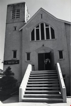
- Photograph shows the Willingdon Heights Community Church, built in 1952, at 4304 Parker Street, on the corner of Parker Street and Madison Avenue.
- Repository
- City of Burnaby Archives
- Date
- October, 1976
- Collection/Fonds
- Burnaby Public Library Contemporary Visual Archive Project
- Physical Description
- 1 photograph : b&w ; 11 x 16 cm mounted on cardboard
- Description Level
- Item
- Record No.
- 556-114
- Access Restriction
- No restrictions
- Reproduction Restriction
- Reproduce for fair dealing purposes only
- Accession Number
- 2013-13
- Scope and Content
- Photograph shows the Willingdon Heights Community Church, built in 1952, at 4304 Parker Street, on the corner of Parker Street and Madison Avenue.
- Subjects
- Buildings - Religious - Churches
- Media Type
- Photograph
- Photographer
- Cook, Alan
- Notes
- Scope note taken directly from BPL photograph description.
- 1 b&w copy negative : 10 x 12.5 cm accompanying
- Geographic Access
- Parker Street
- Street Address
- 4304 Parker Street
- Historic Neighbourhood
- Vancouver Heights (Historic Neighbourhood)
- Planning Study Area
- Willingdon Heights Area
Images
Willingdon Heights Community Church
https://search.heritageburnaby.ca/link/archivedescription79049
- Repository
- City of Burnaby Archives
- Date
- October, 1976
- Collection/Fonds
- Burnaby Public Library Contemporary Visual Archive Project
- Description Level
- Item
- Physical Description
- 1 photograph : b&w ; 11 x 16 cm mounted on cardboard
- Scope and Content
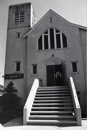
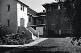
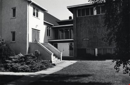
- Photograph shows the Church Hall, library and lounge attached to the Willingdon Heights Community Church, built in 1952, at 4304 Parker Street.
- Repository
- City of Burnaby Archives
- Date
- October, 1976
- Collection/Fonds
- Burnaby Public Library Contemporary Visual Archive Project
- Physical Description
- 1 photograph : b&w ; 11 x 16 cm mounted on cardboard
- Description Level
- Item
- Record No.
- 556-116
- Access Restriction
- No restrictions
- Reproduction Restriction
- Reproduce for fair dealing purposes only
- Accession Number
- 2013-13
- Scope and Content
- Photograph shows the Church Hall, library and lounge attached to the Willingdon Heights Community Church, built in 1952, at 4304 Parker Street.
- Subjects
- Buildings - Religious - Churches
- Media Type
- Photograph
- Photographer
- Cook, Alan
- Notes
- Scope note taken directly from BPL photograph description.
- 1 b&w copy negative : 10 x 12.5 cm accompanying
- Geographic Access
- Parker Street
- Street Address
- 4304 Parker Street
- Historic Neighbourhood
- Vancouver Heights (Historic Neighbourhood)
- Planning Study Area
- Willingdon Heights Area
Images
Willingdon Mennonite Brethren Church
https://search.heritageburnaby.ca/link/archivedescription79069
- Repository
- City of Burnaby Archives
- Date
- November 1, 1976
- Collection/Fonds
- Burnaby Public Library Contemporary Visual Archive Project
- Description Level
- Item
- Physical Description
- 1 photograph : b&w ; 11 x 16 cm mounted on cardboard
- Scope and Content
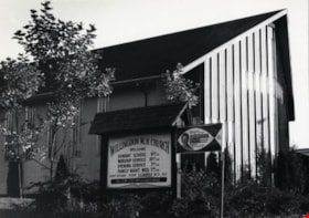
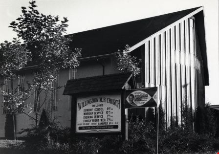
- Photograph shows the Willingdon Mennonite Brethren Church locate at 4812 Willingdon Avenue at the corner of Gilpin Street. Exterior sign gives details of services and advertises an upcoming appearance by Leighton Ford.
- Repository
- City of Burnaby Archives
- Date
- November 1, 1976
- Collection/Fonds
- Burnaby Public Library Contemporary Visual Archive Project
- Physical Description
- 1 photograph : b&w ; 11 x 16 cm mounted on cardboard
- Description Level
- Item
- Record No.
- 556-131
- Access Restriction
- No restrictions
- Reproduction Restriction
- Reproduce for fair dealing purposes only
- Accession Number
- 2013-13
- Scope and Content
- Photograph shows the Willingdon Mennonite Brethren Church locate at 4812 Willingdon Avenue at the corner of Gilpin Street. Exterior sign gives details of services and advertises an upcoming appearance by Leighton Ford.
- Subjects
- Buildings - Religious - Churches
- Media Type
- Photograph
- Notes
- Scope note taken directly from BPL photograph description.
- 1 b&w copy negative : 10 x 12.5 cm accompanying
- Photographers identified by surnames only: Carr and Vardeman
- Geographic Access
- Willingdon Avenue
- Street Address
- 4812 Willingdon Avenue
- Historic Neighbourhood
- Central Park (Historic Neighbourhood)
- Planning Study Area
- Marlborough Area
Images
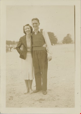
Wilma and Jack
https://search.heritageburnaby.ca/link/museumdescription19522
- Repository
- Burnaby Village Museum
- Date
- 21 Aug. 1938
- Collection/Fonds
- Hawkshaw family fonds
- Description Level
- Item
- Physical Description
- 1 photograph : sepia ; 9 x 6.5 cm
- Scope and Content
- Photograph of Jack Knechtle standing together with a woman named Wilma on beach on Newcastle Island (traditionally known as Saysutshun by the Snuneymuxw people).
- Repository
- Burnaby Village Museum
- Collection/Fonds
- Hawkshaw family fonds
- Description Level
- Item
- Physical Description
- 1 photograph : sepia ; 9 x 6.5 cm
- Scope and Content
- Photograph of Jack Knechtle standing together with a woman named Wilma on beach on Newcastle Island (traditionally known as Saysutshun by the Snuneymuxw people).
- Subjects
- Geographic Features - Beaches
- Names
- Knechtle, Jack Leslie
- Accession Code
- BV996.6.229
- Access Restriction
- No restrictions
- Reproduction Restriction
- No known restrictions
- Date
- 21 Aug. 1938
- Media Type
- Photograph
- Scan Resolution
- 600
- Scan Date
- 2023-02-16
- Notes
- Title based on contents of photograph
- Photograph caption beneath photograph reads: "William & Jack"
- Caption on album page reads "New Castle Island / Aug 21 / 38"
- Photograph is part of photograph album BV996.6.1
Images

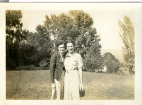
Wilma and Kay
https://search.heritageburnaby.ca/link/museumdescription2709
- Repository
- Burnaby Village Museum
- Date
- July 25, 1937
- Collection/Fonds
- Hawkshaw family fonds
- Description Level
- Item
- Physical Description
- 1 photograph : sepia ; 5.5 x 8 cm
- Scope and Content
- Photograph of Wilma and Kay standing on the lawn outside house located at 3508 Deer Lake (R.F. Anderson house - 6504 Deer Lake Avenue) in Burnaby. Mabel Hawkshaw was living in this house in 1937.
- Repository
- Burnaby Village Museum
- Collection/Fonds
- Hawkshaw family fonds
- Description Level
- Item
- Physical Description
- 1 photograph : sepia ; 5.5 x 8 cm
- Scope and Content
- Photograph of Wilma and Kay standing on the lawn outside house located at 3508 Deer Lake (R.F. Anderson house - 6504 Deer Lake Avenue) in Burnaby. Mabel Hawkshaw was living in this house in 1937.
- Geographic Access
- Deer Lake Avenue
- Accession Code
- BV996.6.150
- Access Restriction
- No restrictions
- Reproduction Restriction
- No known restrictions
- Date
- July 25, 1937
- Media Type
- Photograph
- Historic Neighbourhood
- Burnaby Lake (Historic Neighbourhood)
- Planning Study Area
- Morley-Buckingham Area
- Scan Resolution
- 600
- Scan Date
- 2/18/2010
- Scale
- 100
- Notes
- Title based on contents of photograph
- Caption for photograph reads: "Wilma + Kay"
- Photograph is part of photograph album BV996.6.1
Images

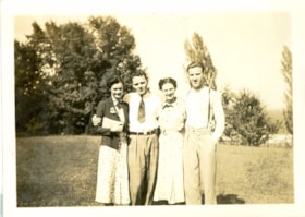
Wilma, Colin, Kay and Crichton
https://search.heritageburnaby.ca/link/museumdescription2712
- Repository
- Burnaby Village Museum
- Date
- July 25, 1937
- Collection/Fonds
- Hawkshaw family fonds
- Description Level
- Item
- Physical Description
- 1 photograph : sepia ; 5.5 x 8 cm
- Scope and Content
- Photograph of Wilma, Colin, Kay and Crichton Hawkshaw standing on the lawn of Mabel Hawkshaw's home located at 3908 Deer Lake Avenue (R.F. Anderson house - 6504 Deer Lake Avenue). Tall trees are visible in the background.
- Repository
- Burnaby Village Museum
- Collection/Fonds
- Hawkshaw family fonds
- Description Level
- Item
- Physical Description
- 1 photograph : sepia ; 5.5 x 8 cm
- Scope and Content
- Photograph of Wilma, Colin, Kay and Crichton Hawkshaw standing on the lawn of Mabel Hawkshaw's home located at 3908 Deer Lake Avenue (R.F. Anderson house - 6504 Deer Lake Avenue). Tall trees are visible in the background.
- Subjects
- Plants - Trees
- Geographic Access
- Deer Lake Avenue
- Accession Code
- BV996.6.153
- Access Restriction
- No restrictions
- Reproduction Restriction
- No known restrictions
- Date
- July 25, 1937
- Media Type
- Photograph
- Historic Neighbourhood
- Burnaby Lake (Historic Neighbourhood)
- Planning Study Area
- Morley-Buckingham Area
- Scan Resolution
- 600
- Scan Date
- 2/9/2010
- Scale
- 100
- Notes
- Title based on contents of photograph
- Caption for photograph reads: "Wilma, Colin, Kay, Me'"
- Note in pencil on verso of photograph reads: "July 25/37"
- Photograph is part of photograph album BV996.6.1
Images

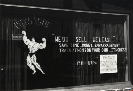
Window Sign
https://search.heritageburnaby.ca/link/archivedescription79929
- Repository
- City of Burnaby Archives
- Date
- September 24, 1976
- Collection/Fonds
- Burnaby Public Library Contemporary Visual Archive Project
- Description Level
- Item
- Physical Description
- 1 photograph : b&w ; 11 x 16 cm mounted on cardboard
- Scope and Content
- Photograph shows a sign in the window of 6953 Kingsway advertising Unique Physique.
- Repository
- City of Burnaby Archives
- Date
- September 24, 1976
- Collection/Fonds
- Burnaby Public Library Contemporary Visual Archive Project
- Physical Description
- 1 photograph : b&w ; 11 x 16 cm mounted on cardboard
- Description Level
- Item
- Record No.
- 556-500
- Access Restriction
- No restrictions
- Reproduction Restriction
- Reproduce for fair dealing purposes only
- Accession Number
- 2013-13
- Scope and Content
- Photograph shows a sign in the window of 6953 Kingsway advertising Unique Physique.
- Media Type
- Photograph
- Photographer
- Born, A. J.
- Notes
- Scope note taken directly from BPL photograph description.
- 1 b&w copy negative : 10 x 12.5 cm accompanying
- Geographic Access
- Kingsway
- Street Address
- 6953 Kingsway
- Historic Neighbourhood
- Edmonds (Historic Neighbourhood)
- Planning Study Area
- Richmond Park Area
Images