Narrow Results By
![Louis Claude Hill's Farm, Burnaby, BC, [1909] thumbnail](/media/hpo/_Data/_BVM_Images/1973/1973_0040_0004_001.jpg?width=280)
Louis Claude Hill's Farm, Burnaby, BC
https://search.heritageburnaby.ca/link/museumdescription3064
- Repository
- Burnaby Village Museum
- Date
- [1909]
- Collection/Fonds
- Burnaby Village Museum Photograph collection
- Description Level
- Item
- Physical Description
- 1 photograph : b&w ; 12.2 x 17.6 cm mounted on cardboard 22.7 x 27.4 cm
- Scope and Content
- Photograph of a farm with men, a horse and wagon, and children in a field. An annotation on the back of one of the photos reads, "The foreground farm property stood at the corner of Sperling Avenue (formerly known as the Pole Line Road) and Buckingham. The white house in the left centre was the …
- Repository
- Burnaby Village Museum
- Collection/Fonds
- Burnaby Village Museum Photograph collection
- Description Level
- Item
- Physical Description
- 1 photograph : b&w ; 12.2 x 17.6 cm mounted on cardboard 22.7 x 27.4 cm
- Scope and Content
- Photograph of a farm with men, a horse and wagon, and children in a field. An annotation on the back of one of the photos reads, "The foreground farm property stood at the corner of Sperling Avenue (formerly known as the Pole Line Road) and Buckingham. The white house in the left centre was the residence of Miss Woodward, her mother and sister. It was the first post office at 'Burnaby Lake' and the site of the kindergarten school of Miss Harriet Woodward. It later became the United Church. / The open field in the distance above the horse's head and people in the field is the field in front of the 'Manor House' which was built by Mr. Bateman in the 1920's. To the right of and beyond the white house partly hidden by the trees can be seen some of the buildings associated with the Hill farm on Deer Lake Ave. which by the date (1909) of this photo had been sold. The distant tall trees (center) stand on the site of the Municipal Buildings (DesBirsays Woods)." An annotation on the back of the other photograph reads, "Formerly belonging to Malcom Nicolson / App. 1908." Annotations at the bottom front of the photograph read, "L. Claude Hill's Farm, Burnaby, BC."
- Subjects
- Agriculture - Crops
- Agricultural Tools and Equipment
- Animals - Horses
- Occupations - Farmers
- Agriculture - Farms
- Geographic Access
- Buckingham Avenue
- Sperling Avenue
- Accession Code
- HV973.40.4
- Access Restriction
- No restrictions
- Reproduction Restriction
- No known restrictions
- Date
- [1909]
- Media Type
- Photograph
- Historic Neighbourhood
- Burnaby Lake (Historic Neighbourhood)
- Planning Study Area
- Morley-Buckingham Area
- Scan Resolution
- 600
- Scan Date
- 2023-05-09
- Scale
- 100
- Notes
- Title based on contents of photograph
- 1 b&w duplicate photograph accompanying
- Text on first image "L Claude Hill's Farm, Burnaby B C", incorporated into the image at the bottom edge of the photograph. "app 1909" pencilled in following above on the bottom edge of the image "L. Claude / Hill / Broadview", pencilled on the matt below the image. "The foreground farm property stood at the / Corner of Sperling Ave. (formerly known as Pole Line Road) / and Buckingham. The white house in the left / centre was the residence of Miss Woodward, her mother / and sister. It was the first post ofice at "Burnaby Lake" / and the site of the kindergarten school of Miss / Harriet Woodward. It later became the United / Church. / The open field in the distance above / the horses head and people in the field is / the field in front of the "Manse House" which / was built by Mr. Bateman in the 1920's. To the / right of and beyond the white house partly hidden / by the trees can be seen some of the buildings / associated with the Hill farm on Deer Lake Ave. / which by the date (1909) of this photo had been / sold. The distant tall trees (center) stand on the site of / the Municipal Buildings (DesBirsays Woods)", hand written in blue ink on the reverse side of the matt. It is not indicated who wrote the note. "OR MASTER / 973.40.4", pencilled in the lower right corner of reverse side of matt. "W. T. COOKSLEY / NEW WESTMINSTER, B.C."printed with very little contrast on the gray mattboard, below the lower right corner of the photograph Text on second image. "L Claude Hill's Farm, Burnaby B C", incorporated into the image at the bottom edge of the photograph. "Claude surveying the haying", pencilled on the reverse side of the matt. "Formerly belonging to Malcolm Nicholson / app 1908", hand writen in blue ink on the reverse side of the matt. "H.V.973.40.4. OR. MASTER", hand printed on the bottom left corner of the reverse side of the matt. "W. T. COOKSLEY / NEW WESTMINSTER, B.C."printed with very little contrast on the gray mattboard, below the lower right corner of the photograph
Images
![Louis Claude Hill's Farm, Burnaby, BC, [1909] thumbnail](/media/hpo/_Data/_BVM_Images/1973/1973_0040_0004_001.jpg)

![Hill brothers in swimsuits, [1901] (date of original), copied 1977 thumbnail](/media/hpo/_Data/_BVM_Images/1977/1977_0123_0029_001.jpg?width=280)
Hill brothers in swimsuits
https://search.heritageburnaby.ca/link/museumdescription623
- Repository
- Burnaby Village Museum
- Date
- [1901] (date of original), copied 1977
- Collection/Fonds
- Burnaby Village Museum Photograph collection
- Description Level
- Item
- Physical Description
- 1 photograph : b&w ; 20.2 x 25.2 cm print
- Scope and Content
- Photograph of five boys in swimsuits. The youngest is sitting down in the centre, two are squatting behind him, and two are standing with their arms crossed behind the squatting boys. They are on a plank board pier with a wooden boat beside them. This photograph is reproduced in Michael Sone's book…
- Repository
- Burnaby Village Museum
- Collection/Fonds
- Burnaby Village Museum Photograph collection
- Description Level
- Item
- Physical Description
- 1 photograph : b&w ; 20.2 x 25.2 cm print
- Scope and Content
- Photograph of five boys in swimsuits. The youngest is sitting down in the centre, two are squatting behind him, and two are standing with their arms crossed behind the squatting boys. They are on a plank board pier with a wooden boat beside them. This photograph is reproduced in Michael Sone's book, "Pioneer Tales of Burnaby," pg. 28. The caption reads: "Gerry Hill (foreground) [youngest son of Bernard Hill] with brothers and friends after swim in Deer Lake c. 1901."
- Geographic Access
- Deer Lake
- Deer Lake Avenue
- Accession Code
- HV977.123.29
- Access Restriction
- No restrictions
- Reproduction Restriction
- No known restrictions
- Date
- [1901] (date of original), copied 1977
- Media Type
- Photograph
- Historic Neighbourhood
- Burnaby Lake (Historic Neighbourhood)
- Planning Study Area
- Morley-Buckingham Area
- Scan Resolution
- 600
- Scan Date
- 2023-07-25
- Notes
- Title based on contents of photograph
Images
![Hill brothers in swimsuits, [1901] (date of original), copied 1977 thumbnail](/media/hpo/_Data/_BVM_Images/1977/1977_0123_0029_001.jpg)
![Deer Lake BC, [190-?] thumbnail](/media/hpo/_Data/_BVM_Images/1976//1976_0139_0001_001.jpg?width=280)
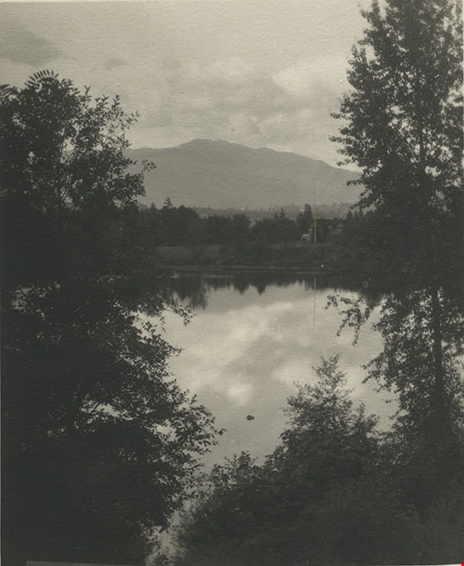
Deer Lake BC
https://search.heritageburnaby.ca/link/museumdescription750
- Repository
- Burnaby Village Museum
- Date
- [190-?]
- Collection/Fonds
- Burnaby Village Museum Photograph collection
- Description Level
- Item
- Physical Description
- 1 photograph : b&w photogravure on paper ; 10.0 x 12.7 cm
- Scope and Content
- Photograph of the north side of Deer Lake, including the Hart family's "Avalon" estate (which later became Hart House restaurant). The photograph was likely taken from a hill on Sperling Avenue. The photogravure has been made into a greeting card. Printed on the bottom front of the card: "Deer Lak…
- Repository
- Burnaby Village Museum
- Collection/Fonds
- Burnaby Village Museum Photograph collection
- Description Level
- Item
- Physical Description
- 1 photograph : b&w photogravure on paper ; 10.0 x 12.7 cm
- Scope and Content
- Photograph of the north side of Deer Lake, including the Hart family's "Avalon" estate (which later became Hart House restaurant). The photograph was likely taken from a hill on Sperling Avenue. The photogravure has been made into a greeting card. Printed on the bottom front of the card: "Deer Lake B.C. / May your Christmas be a Merry One / And the New Year full of Happiness." An annotation on the back of the back of the card reads, "Looking NNE. / probably from hill on Sperling Ave."
- Geographic Access
- Deer Lake Avenue
- Deer Lake
- Street Address
- 6664 Deer Lake Avenue
- Accession Code
- HV976.139.1
- Access Restriction
- No restrictions
- Reproduction Restriction
- No known restrictions
- Date
- [190-?]
- Media Type
- Photograph
- Historic Neighbourhood
- Burnaby Lake (Historic Neighbourhood)
- Planning Study Area
- Morley-Buckingham Area
- Scan Resolution
- 600
- Scan Date
- 2023-06-20
- Notes
- Transcribed title
Images
![Deer Lake BC, [190-?] thumbnail](/media/hpo/_Data/_BVM_Images/1976//1976_0139_0001_001.jpg)
![Brookfield, [1900] thumbnail](/media/hpo/_Data/_BVM_Images/1976/1976_0139_0005_001.jpg?width=280)
Brookfield
https://search.heritageburnaby.ca/link/museumdescription754
- Repository
- Burnaby Village Museum
- Date
- [1900]
- Collection/Fonds
- Burnaby Village Museum Photograph collection
- Description Level
- Item
- Physical Description
- 1 photograph : b&w ; 9.9 x 14.0 cm mounted on cardboard 17.8 x 23.0 cm
- Scope and Content
- Photograph of "Brookfield", the first home of Mr. and Mrs. Louis Claude Hill. The Hills, including the daughter Kitty Hill, are on the lawn on the lower right corner. The man sitting on the steps is identified by the inscription on the photograph card mount as Mr. Wetenhall. Annotations on the back…
- Repository
- Burnaby Village Museum
- Collection/Fonds
- Burnaby Village Museum Photograph collection
- Description Level
- Item
- Physical Description
- 1 photograph : b&w ; 9.9 x 14.0 cm mounted on cardboard 17.8 x 23.0 cm
- Scope and Content
- Photograph of "Brookfield", the first home of Mr. and Mrs. Louis Claude Hill. The Hills, including the daughter Kitty Hill, are on the lawn on the lower right corner. The man sitting on the steps is identified by the inscription on the photograph card mount as Mr. Wetenhall. Annotations on the back of the card read: "'Brookfield' / Burnaby Lake" and "L.C. Hill & Kitty M. Hill, Mr. Wetenhall." Another annotation reads: "App. 1900."
- Subjects
- Buildings - Residential - Houses
- Geographic Access
- Deer Lake Avenue
- Street Address
- 6501 Deer Lake Avenue
- Accession Code
- HV976.139.5
- Access Restriction
- No restrictions
- Reproduction Restriction
- No known restrictions
- Date
- [1900]
- Media Type
- Photograph
- Historic Neighbourhood
- Burnaby Lake (Historic Neighbourhood)
- Planning Study Area
- Morley-Buckingham Area
- Related Material
- For another view of Brookfield home, see HV976.139.53
- Scan Resolution
- 600
- Scan Date
- 2023-06-27
- Notes
- Title based on contents of photograph
Images
![Brookfield, [1900] thumbnail](/media/hpo/_Data/_BVM_Images/1976/1976_0139_0005_001.jpg)
