Narrow Results By
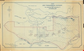
Part of the New Westminster District shewing the Proposed New Municipality of Burnaby
https://search.heritageburnaby.ca/link/museumdescription17544
- Repository
- Burnaby Village Museum
- Date
- 1891 (date of original)
- Collection/Fonds
- Burnaby Village Museum Map collection
- Description Level
- Item
- Physical Description
- 1 map : blueline print with col. ; 59 x 96 cm
- Scope and Content
- Item consists of a map titled "Part of the New Westminster District shewing the Proposed New Municipality of Burnaby". The map shows boundaries of a proposed new municipality of Burnaby including all land outside of the "old" City of Vancouver between Burrard Inlet and the Fraser River and west of …
- Repository
- Burnaby Village Museum
- Collection/Fonds
- Burnaby Village Museum Map collection
- Description Level
- Item
- Physical Description
- 1 map : blueline print with col. ; 59 x 96 cm
- Material Details
- Scale approx. [1:31,680]
- Scope and Content
- Item consists of a map titled "Part of the New Westminster District shewing the Proposed New Municipality of Burnaby". The map shows boundaries of a proposed new municipality of Burnaby including all land outside of the "old" City of Vancouver between Burrard Inlet and the Fraser River and west of North Road. Map also shows the boundaries of the District Lots. Signed by Garden, Hermon and Burwell Provincial Land Surveyors, Vancouver, June 5, 1891. Blueline print is hand-coloured highlighting Burnaby.
- Creator
- Garden, Hermon and Burwell
- Accession Code
- BV994.29.1
- Access Restriction
- No restrictions
- Reproduction Restriction
- No known restrictions
- Date
- 1891 (date of original)
- Media Type
- Cartographic Material
- Scan Resolution
- 300
- Scan Date
- 2022-05-10
- Notes
- Transcribed title
