Narrow Results By

Survey made by Albert J. Hill
https://search.heritageburnaby.ca/link/museumdescription11149
- Repository
- Burnaby Village Museum
- Date
- 1885
- Collection/Fonds
- Ronald G. Scobbie collection
- Description Level
- Item
- Physical Description
- 1 survey plan : blueprint ; 43 x 30 cm
- Scope and Content
- Item consists of a "Survey" / Made by Albert J. Hill" re the north boundary of district lots 9 and 107 on the east side of North Road.
- Repository
- Burnaby Village Museum
- Collection/Fonds
- Ronald G. Scobbie collection
- Description Level
- Item
- Physical Description
- 1 survey plan : blueprint ; 43 x 30 cm
- Scope and Content
- Item consists of a "Survey" / Made by Albert J. Hill" re the north boundary of district lots 9 and 107 on the east side of North Road.
- Creator
- Hill, Albert James
- Geographic Access
- North Road
- Accession Code
- BV003.83.28
- Access Restriction
- No restrictions
- Reproduction Restriction
- No known restrictions
- Date
- 1885
- Media Type
- Cartographic Material
- Scan Resolution
- 600
- Scan Date
- 15-Jan-2021
- Scale
- 100
- Notes
- Transcribed title
- Handwritten note pasted in upper right corner reads: "This is the blue print referred to in the letter" "dated. 13. December - 1910, sent by order of the Board to Messrs W.N. Draper & Albert J. Hill" "Re: North Boundary. Lots. 9 & 107." "New Westminster District" "Corp. B.C.L. Surveyors" "Victoria. B.C." "-- Roberts" "Sec Treas & Registrar"
- Note in pencil on verso reads: “North / Road”
- Note in red crayon on verso reads: “001607”
Images

![Survey plan of District Lot 25, [190-] thumbnail](/media/hpo/_Data/_BVM_Cartographic_Material/1992/1992_0026_0027_001.jpg?width=280)
Survey plan of District Lot 25
https://search.heritageburnaby.ca/link/museumdescription18807
- Repository
- Burnaby Village Museum
- Date
- [190-]
- Collection/Fonds
- Love family fonds
- Description Level
- Item
- Physical Description
- 1 plan : black ink on linen ; 23 x 14 cm
- Scope and Content
- Item consists of a survey plan created by Provincial Land Surveyor Albert J. Hill with lots numbered one to six of District Lot 25, Lot 6 noted as owned by "Debeck", next to lot no. owned by "Newcombe", Lots numbered 11 to 13 on the other side of Cumberland Street.
- Repository
- Burnaby Village Museum
- Collection/Fonds
- Love family fonds
- Description Level
- Item
- Physical Description
- 1 plan : black ink on linen ; 23 x 14 cm
- Scope and Content
- Item consists of a survey plan created by Provincial Land Surveyor Albert J. Hill with lots numbered one to six of District Lot 25, Lot 6 noted as owned by "Debeck", next to lot no. owned by "Newcombe", Lots numbered 11 to 13 on the other side of Cumberland Street.
- Creator
- Hill, Albert James
- Accession Code
- BV992.26.27
- Access Restriction
- No restrictions
- Reproduction Restriction
- No known restrictions
- Date
- [190-]
- Media Type
- Cartographic Material
- Notes
- Title based on contents of item
- Map: hand-drawn in black ink on small rectangle of linen; shows area of "CITY, SUBURBAN.", by Albert J. Hill, P.L.S.; Tenth Avenue, Third Avenue, Armstrong Street, Cumberland Street; lots 1-6 of L.25, dimensions given; L.6 is owned by "Debeck", next lot no number by "Newcombe"; lots 11 and 13 on other side of Cumberland St.; signature J.C. Armstrong; "4" in circle; L.1 is subdivided with pencilled lines
Images
![Survey plan of District Lot 25, [190-] thumbnail](/media/hpo/_Data/_BVM_Cartographic_Material/1992/1992_0026_0027_001.jpg)
Map of Burnaby Municipality
https://search.heritageburnaby.ca/link/museumdescription9669
- Repository
- Burnaby Village Museum
- Date
- [1922]
- Collection/Fonds
- Ronald G. Scobbie collection
- Description Level
- Item
- Physical Description
- 1 map : black ink ; 66.5 x 54 cm, on waxed linen sheet 70.5 x 48.5 cm
- Scope and Content
- Item consists of a map of the Burnaby Municipality. The map identifies various land features such as: District Lots with names of property owners and parks, wards, railways, roads and water ways.
- Repository
- Burnaby Village Museum
- Collection/Fonds
- Ronald G. Scobbie collection
- Description Level
- Item
- Physical Description
- 1 map : black ink ; 66.5 x 54 cm, on waxed linen sheet 70.5 x 48.5 cm
- Material Details
- Scale 1:31680
- Scope and Content
- Item consists of a map of the Burnaby Municipality. The map identifies various land features such as: District Lots with names of property owners and parks, wards, railways, roads and water ways.
- Creator
- Hill, Albert James
- Accession Code
- BV003.83.42
- Access Restriction
- No restrictions
- Reproduction Restriction
- No known restrictions
- Date
- [1922]
- Media Type
- Cartographic Material
- Notes
- Transcribed title
- Map is signed by "Albert J. Hill / Civil Engineer / and / Provincial Land Surveyor / New Westminster / B.C."
- Title on map reads: "Map / of / Burnaby Municipality"
- Scale: "40 chs = 1 in."
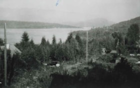
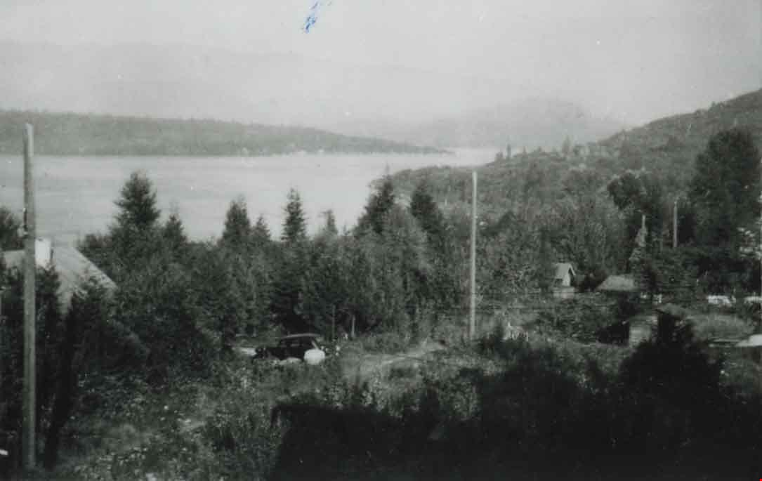
McGill Street, Vancouver Heights
https://search.heritageburnaby.ca/link/archivedescription37426
- Repository
- City of Burnaby Archives
- Date
- 1946 (date of original), copied 1991
- Collection/Fonds
- Burnaby Historical Society fonds
- Description Level
- Item
- Physical Description
- 1 photograph : b&w ; 3.0 x 4.6 cm print on contact sheet 20.2 x 25.4 cm
- Scope and Content
- Photograph of 4151 McGill Street, looking down on McGill Street from an elevation. Burrard Inlet is visible in the background.
- Repository
- City of Burnaby Archives
- Date
- 1946 (date of original), copied 1991
- Collection/Fonds
- Burnaby Historical Society fonds
- Subseries
- Burnaby Image Bank subseries
- Physical Description
- 1 photograph : b&w ; 3.0 x 4.6 cm print on contact sheet 20.2 x 25.4 cm
- Description Level
- Item
- Record No.
- 370-014
- Access Restriction
- No restrictions
- Reproduction Restriction
- No known restrictions
- Accession Number
- BHS1999-03
- Scope and Content
- Photograph of 4151 McGill Street, looking down on McGill Street from an elevation. Burrard Inlet is visible in the background.
- Subjects
- Geographic Features - Inlets
- Media Type
- Photograph
- Photographer
- Anderson, Robert "Bob"
- Notes
- Title based on contents of photograph
- 1 b&w copy negative accompanying
- Geographic Access
- McGill Street
- Street Address
- 4151 McGill Street
- Historic Neighbourhood
- Vancouver Heights (Historic Neighbourhood)
- Planning Study Area
- Burnaby Heights Area
Images
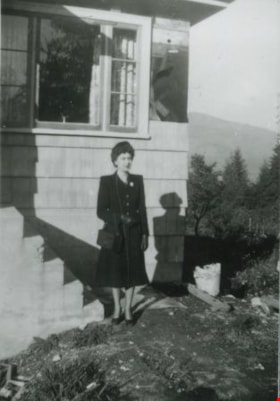
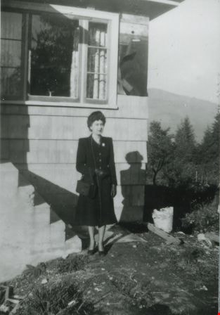
Madelaine Anderson
https://search.heritageburnaby.ca/link/archivedescription37428
- Repository
- City of Burnaby Archives
- Date
- 1947 (date of original), copied 1991
- Collection/Fonds
- Burnaby Historical Society fonds
- Description Level
- Item
- Physical Description
- 1 photograph : b&w ; 4.2 x 3.5 cm print on contact sheet 20.2 x 25.3 cm
- Scope and Content
- Photograph of Madelaine Anderson in front of the Anderson family home at 4151 McGill Street after its completed construction.
- Repository
- City of Burnaby Archives
- Date
- 1947 (date of original), copied 1991
- Collection/Fonds
- Burnaby Historical Society fonds
- Subseries
- Burnaby Image Bank subseries
- Physical Description
- 1 photograph : b&w ; 4.2 x 3.5 cm print on contact sheet 20.2 x 25.3 cm
- Description Level
- Item
- Record No.
- 370-016
- Access Restriction
- No restrictions
- Reproduction Restriction
- Reproduce for fair dealing purposes only
- Accession Number
- BHS1999-03
- Scope and Content
- Photograph of Madelaine Anderson in front of the Anderson family home at 4151 McGill Street after its completed construction.
- Media Type
- Photograph
- Photographer
- Anderson, Robert "Bob"
- Notes
- Title based on contents of photograph
- 1 b&w copy negative accompanying
- Geographic Access
- McGill Street
- Street Address
- 4151 McGill Street
- Historic Neighbourhood
- Vancouver Heights (Historic Neighbourhood)
- Planning Study Area
- Burnaby Heights Area
Images