Narrow Results By
Subject
- Aerial Photographs 16
- Buildings - Industrial - Refineries 1
- Buildings - Recreational 1
- Buildings - Schools - Universities and Colleges 3
- Geographic Features - Inlets 8
- Geographic Features - Mountains 2
- Geographic Features - Parks 1
- Natural Phenomena - Snow 10
- Organizations - Girls' Societies and Clubs 2
- Persons - Children 1
- Recreational Activities - Hiking 1
- Recreational Devices - Playgrounds 1
Aerial photograph of Burnaby
https://search.heritageburnaby.ca/link/archivedescription84893
- Repository
- City of Burnaby Archives
- Date
- 1963
- Collection/Fonds
- Allan Amundsen collection
- Description Level
- Item
- Physical Description
- 1 photograph : b&w ; 22.5 x 22.5 cm
- Scope and Content
- Aerial photograph of Burnaby north of Lougheed Highway and west of Sperling Avenue.
- Repository
- City of Burnaby Archives
- Date
- 1963
- Collection/Fonds
- Allan Amundsen collection
- Physical Description
- 1 photograph : b&w ; 22.5 x 22.5 cm
- Description Level
- Item
- Record No.
- 561-014
- Access Restriction
- In Archives only
- Reproduction Restriction
- No reproduction permitted
- Accession Number
- 2014-08
- Scope and Content
- Aerial photograph of Burnaby north of Lougheed Highway and west of Sperling Avenue.
- Subjects
- Aerial Photographs
- Media Type
- Photograph
- Photographer
- Province of British Columbia
- Notes
- Title based on contents of photograph
- This photo is indentified as BC5061:119 and connects with B.C. air photograph BC5061:118 to the west and BC5061:120 to the east
- Geographic Access
- Burnaby Mountain Conservation Area
- Historic Neighbourhood
- Lozells (Historic Neighbourhood)
- Planning Study Area
- Sperling-Broadway Area
- Lake City Area
- Government Road Area
Aerial photograph of Burnaby
https://search.heritageburnaby.ca/link/archivedescription84894
- Repository
- City of Burnaby Archives
- Date
- 1963
- Collection/Fonds
- Allan Amundsen collection
- Description Level
- Item
- Physical Description
- 1 photograph : b&w ; 22.5 x 22.5 cm
- Scope and Content
- Aerial photograph of Burnaby north of Broadway and west of Sperling Avenue.
- Repository
- City of Burnaby Archives
- Date
- 1963
- Collection/Fonds
- Allan Amundsen collection
- Physical Description
- 1 photograph : b&w ; 22.5 x 22.5 cm
- Description Level
- Item
- Record No.
- 561-015
- Access Restriction
- In Archives only
- Reproduction Restriction
- No reproduction permitted
- Accession Number
- 2014-08
- Scope and Content
- Aerial photograph of Burnaby north of Broadway and west of Sperling Avenue.
- Subjects
- Aerial Photographs
- Media Type
- Photograph
- Photographer
- Province of British Columbia
- Notes
- Title based on contents of photograph
- This photo is indentified as BC5061:120 and connects with B.C. air photograph BC5061:119 to the west and BC5061:121 to the east
- Geographic Access
- Burnaby Mountain Conservation Area
- Historic Neighbourhood
- Lozells (Historic Neighbourhood)
- Planning Study Area
- Sperling-Broadway Area
- Lake City Area
- Government Road Area
- Burnaby Mountain Area
Aerial photograph of Burnaby
https://search.heritageburnaby.ca/link/archivedescription84896
- Repository
- City of Burnaby Archives
- Date
- 1963
- Collection/Fonds
- Allan Amundsen collection
- Description Level
- Item
- Physical Description
- 1 photograph : b&w ; 22.5 x 22.5 cm
- Scope and Content
- Aerial photograph of Burnaby north of Broadway and west of Sperling Avenue.
- Repository
- City of Burnaby Archives
- Date
- 1963
- Collection/Fonds
- Allan Amundsen collection
- Physical Description
- 1 photograph : b&w ; 22.5 x 22.5 cm
- Description Level
- Item
- Record No.
- 561-016
- Access Restriction
- In Archives only
- Reproduction Restriction
- No reproduction permitted
- Accession Number
- 2014-08
- Scope and Content
- Aerial photograph of Burnaby north of Broadway and west of Sperling Avenue.
- Subjects
- Aerial Photographs
- Media Type
- Photograph
- Photographer
- Province of British Columbia
- Notes
- Title based on contents of photograph
- This photo is indentified as BC5061:121 and connects with B.C. air photograph BC5061:120 to the west and BC5061:122 to the east
- Geographic Access
- Burnaby Mountain Conservation Area
- Historic Neighbourhood
- Lozells (Historic Neighbourhood)
- Planning Study Area
- Sperling-Broadway Area
- Lake City Area
- Government Road Area
- Burnaby Mountain Area
Aerial photograph of Burnaby Mountain
https://search.heritageburnaby.ca/link/archivedescription84882
- Repository
- City of Burnaby Archives
- Date
- 1963
- Collection/Fonds
- Allan Amundsen collection
- Description Level
- Item
- Physical Description
- 1 photograph : b&w ; 22.5 x 22.5 cm
- Scope and Content
- Aerial photograph of Burnaby Mountain and surrounding area with Burrard Inlet to the north.
- Repository
- City of Burnaby Archives
- Date
- 1963
- Collection/Fonds
- Allan Amundsen collection
- Physical Description
- 1 photograph : b&w ; 22.5 x 22.5 cm
- Description Level
- Item
- Record No.
- 561-003
- Access Restriction
- In Archives only
- Reproduction Restriction
- No reproduction permitted
- Accession Number
- 2014-08
- Scope and Content
- Aerial photograph of Burnaby Mountain and surrounding area with Burrard Inlet to the north.
- Media Type
- Photograph
- Photographer
- Province of British Columbia
- Notes
- Title based on contents of photograph
- This photo is indentified as BC5061:83 and connects with B.C. air photograph BC5061:84 to the west and BC5061:82 to the east
- Geographic Access
- Burrard Inlet
- Burnaby Mountain Conservation Area
- Historic Neighbourhood
- Barnet (Historic Neighbourhood)
- Lochdale (Historic Neighbourhood)
- Planning Study Area
- Westridge Area
- Burnaby Mountain Area
- Lake City Area
Aerial photograph of Burnaby Mountain
https://search.heritageburnaby.ca/link/archivedescription84883
- Repository
- City of Burnaby Archives
- Date
- 1963
- Collection/Fonds
- Allan Amundsen collection
- Description Level
- Item
- Physical Description
- 1 photograph : b&w ; 22.5 x 22.5 cm
- Scope and Content
- Aerial photograph of Burnaby Mountain and surrounding area with Burrard Inlet to the north.
- Repository
- City of Burnaby Archives
- Date
- 1963
- Collection/Fonds
- Allan Amundsen collection
- Physical Description
- 1 photograph : b&w ; 22.5 x 22.5 cm
- Description Level
- Item
- Record No.
- 561-004
- Access Restriction
- In Archives only
- Reproduction Restriction
- No reproduction permitted
- Accession Number
- 2014-08
- Scope and Content
- Aerial photograph of Burnaby Mountain and surrounding area with Burrard Inlet to the north.
- Media Type
- Photograph
- Photographer
- Province of British Columbia
- Notes
- Title based on contents of photograph
- This photo is indentified as BC5061:82 and connects with B.C. air photograph BC5061:83 to the west and BC5061:81 to the east.
- Geographic Access
- Burrard Inlet
- Burnaby Mountain Conservation Area
- Historic Neighbourhood
- Barnet (Historic Neighbourhood)
- Planning Study Area
- Burnaby Mountain Area
- Lake City Area
Aerial photograph of Burnaby Mountain
https://search.heritageburnaby.ca/link/archivedescription84884
- Repository
- City of Burnaby Archives
- Date
- 1963
- Collection/Fonds
- Allan Amundsen collection
- Description Level
- Item
- Physical Description
- 1 photograph : b&w ; 22.5 x 22.5 cm
- Scope and Content
- Aerial photograph of Burnaby Mountain and surrounding area with Burrard Inlet to the north.
- Repository
- City of Burnaby Archives
- Date
- 1963
- Collection/Fonds
- Allan Amundsen collection
- Physical Description
- 1 photograph : b&w ; 22.5 x 22.5 cm
- Description Level
- Item
- Record No.
- 561-005
- Access Restriction
- In Archives only
- Reproduction Restriction
- No reproduction permitted
- Accession Number
- 2014-08
- Scope and Content
- Aerial photograph of Burnaby Mountain and surrounding area with Burrard Inlet to the north.
- Media Type
- Photograph
- Photographer
- Province of British Columbia
- Notes
- Title based on contents of photograph
- This photo is indentified as BC5061:81 and connects with B.C. air photograph BC5061:82 to the west and BC5061:80 to the east.
- Geographic Access
- Burrard Inlet
- Burnaby Mountain Conservation Area
- Historic Neighbourhood
- Barnet (Historic Neighbourhood)
- Planning Study Area
- Burnaby Mountain Area
Aerial photograph of Burnaby Mountain and Port Moody
https://search.heritageburnaby.ca/link/archivedescription84885
- Repository
- City of Burnaby Archives
- Date
- 1963
- Collection/Fonds
- Allan Amundsen collection
- Description Level
- Item
- Physical Description
- 1 photograph : b&w ; 22.5 x 22.5 cm
- Scope and Content
- Aerial photograph of Burnaby Mountain to the west, Burrard Inlet to the north and Port Moody to the east.
- Repository
- City of Burnaby Archives
- Date
- 1963
- Collection/Fonds
- Allan Amundsen collection
- Physical Description
- 1 photograph : b&w ; 22.5 x 22.5 cm
- Description Level
- Item
- Record No.
- 561-006
- Access Restriction
- In Archives only
- Reproduction Restriction
- No reproduction permitted
- Accession Number
- 2014-08
- Scope and Content
- Aerial photograph of Burnaby Mountain to the west, Burrard Inlet to the north and Port Moody to the east.
- Media Type
- Photograph
- Photographer
- Province of British Columbia
- Notes
- Title based on contents of photograph
- This photo is indentified as BC5061:80 and connects with B.C. air photograph BC5061:81 to the west and BC5061:79 to the east.
- Geographic Access
- Burrard Inlet
- Burnaby Mountain Conservation Area
- Historic Neighbourhood
- Barnet (Historic Neighbourhood)
- Planning Study Area
- Burnaby Mountain Area
Aerial photograph of Burnaby Mountain and Port Moody
https://search.heritageburnaby.ca/link/archivedescription84895
- Repository
- City of Burnaby Archives
- Date
- 1963
- Collection/Fonds
- Allan Amundsen collection
- Description Level
- Item
- Physical Description
- 1 photograph : b&w ; 22.5 x 22.5 cm
- Scope and Content
- Aerial photograph of Burnaby Mountain, north of Broadway .
- Repository
- City of Burnaby Archives
- Date
- 1963
- Collection/Fonds
- Allan Amundsen collection
- Physical Description
- 1 photograph : b&w ; 22.5 x 22.5 cm
- Description Level
- Item
- Record No.
- 561-017
- Access Restriction
- In Archives only
- Reproduction Restriction
- No reproduction permitted
- Accession Number
- 2014-08
- Scope and Content
- Aerial photograph of Burnaby Mountain, north of Broadway .
- Subjects
- Aerial Photographs
- Media Type
- Photograph
- Photographer
- Province of British Columbia
- Notes
- Title based on contents of photograph
- This photo is indentified as BC5061:122 and connects with B.C. air photograph BC5061:121 to the west and BC5061:123 to the east
- Geographic Access
- Burnaby Mountain Conservation Area
- Historic Neighbourhood
- Burquitlam (Historic Neighbourhood)
- Planning Study Area
- Lake City Area
- Burnaby Mountain Area
- Lyndhurst Area
Aerial photograph of Burnaby Mountain and Port Moody
https://search.heritageburnaby.ca/link/archivedescription84897
- Repository
- City of Burnaby Archives
- Date
- 1963
- Collection/Fonds
- Allan Amundsen collection
- Description Level
- Item
- Physical Description
- 1 photograph : b&w ; 22.5 x 22.5 cm
- Scope and Content
- Aerial photograph of North Road and Burnaby Mountain to the west and Port Moody to the east, north of Broadway (Como Lake Avenue).
- Repository
- City of Burnaby Archives
- Date
- 1963
- Collection/Fonds
- Allan Amundsen collection
- Physical Description
- 1 photograph : b&w ; 22.5 x 22.5 cm
- Description Level
- Item
- Record No.
- 561-018
- Access Restriction
- In Archives only
- Reproduction Restriction
- No reproduction permitted
- Accession Number
- 2014-08
- Scope and Content
- Aerial photograph of North Road and Burnaby Mountain to the west and Port Moody to the east, north of Broadway (Como Lake Avenue).
- Subjects
- Aerial Photographs
- Media Type
- Photograph
- Photographer
- Province of British Columbia
- Notes
- Title based on contents of photograph
- This photo is indentified as BC5061:123 and connects with B.C. air photograph BC5061:122 to the west and BC5061:124 to the east
- Geographic Access
- Burnaby Mountain Conservation Area
- Historic Neighbourhood
- Burquitlam (Historic Neighbourhood)
- Planning Study Area
- Lake City Area
- Burnaby Mountain Area
Aerial photograph of North Burnaby
https://search.heritageburnaby.ca/link/archivedescription84881
- Repository
- City of Burnaby Archives
- Date
- 1963
- Collection/Fonds
- Allan Amundsen collection
- Description Level
- Item
- Physical Description
- 1 photograph : b&w ; 22.5 x 22.5 cm
- Scope and Content
- Aerial photograph of North Burnaby with Burrard Inlet to the north and Hastings Street, Inlet Drive, Barnet Road.
- Repository
- City of Burnaby Archives
- Date
- 1963
- Collection/Fonds
- Allan Amundsen collection
- Physical Description
- 1 photograph : b&w ; 22.5 x 22.5 cm
- Description Level
- Item
- Record No.
- 561-002
- Access Restriction
- In Archives only
- Reproduction Restriction
- No reproduction permitted
- Accession Number
- 2014-08
- Scope and Content
- Aerial photograph of North Burnaby with Burrard Inlet to the north and Hastings Street, Inlet Drive, Barnet Road.
- Media Type
- Photograph
- Photographer
- Province of British Columbia
- Notes
- Title based on contents of photograph
- This photo is indentified as BC5061:84 and connects with B.C. air photograph BC5061:85 to the west and BC5061:83 to the east
- Geographic Access
- Burrard Inlet
- Burnaby Mountain Conservation Area
- Historic Neighbourhood
- Capitol Hill (Historic Neighbourhood)
- Lochdale (Historic Neighbourhood)
- Planning Study Area
- Parkcrest-Aubrey Area
- Westridge Area
Aerial photograph of North Burnaby
https://search.heritageburnaby.ca/link/archivedescription93598
- Repository
- City of Burnaby Archives
- Date
- 1963
- Collection/Fonds
- Allan Amundsen collection
- Description Level
- Item
- Physical Description
- 1 photograph : b&w ; 22.5 x 22.5 cm
- Scope and Content
- Aerial photograph of North Burnaby with Burrard Inlet to the north and Hastings Street, Inlet Drive, Barnet Road.
- Repository
- City of Burnaby Archives
- Date
- 1963
- Collection/Fonds
- Allan Amundsen collection
- Physical Description
- 1 photograph : b&w ; 22.5 x 22.5 cm
- Description Level
- Item
- Record No.
- 561-001
- Access Restriction
- In Archives only
- Reproduction Restriction
- No reproduction permitted
- Accession Number
- 2014-08
- Scope and Content
- Aerial photograph of North Burnaby with Burrard Inlet to the north and Hastings Street, Inlet Drive, Barnet Road.
- Media Type
- Photograph
- Photographer
- Province of British Columbia
- Notes
- Title based on contents of photograph
- This photo is identified as BC5061:85
- Geographic Access
- Burrard Inlet
- Burnaby Mountain Conservation Area
- Historic Neighbourhood
- Capitol Hill (Historic Neighbourhood)
- Lochdale (Historic Neighbourhood)
- Planning Study Area
- Parkcrest-Aubrey Area
- Westridge Area
Aerial photograph of Port Moody
https://search.heritageburnaby.ca/link/archivedescription84886
- Repository
- City of Burnaby Archives
- Date
- 1963
- Collection/Fonds
- Allan Amundsen collection
- Description Level
- Item
- Physical Description
- 1 photograph : b&w ; 22.5 x 22.5 cm
- Scope and Content
- Aerial photograph of Port Moody with Burrard Inlet and Barnet Highway to the north and Burnaby Mountain to the east.
- Repository
- City of Burnaby Archives
- Date
- 1963
- Collection/Fonds
- Allan Amundsen collection
- Physical Description
- 1 photograph : b&w ; 22.5 x 22.5 cm
- Description Level
- Item
- Record No.
- 561-007
- Access Restriction
- In Archives only
- Reproduction Restriction
- No reproduction permitted
- Accession Number
- 2014-08
- Scope and Content
- Aerial photograph of Port Moody with Burrard Inlet and Barnet Highway to the north and Burnaby Mountain to the east.
- Media Type
- Photograph
- Photographer
- Province of British Columbia
- Notes
- Title based on contents of photograph
- This photo is indentified as BC5061:79 and connects with B.C. air photograph BC5061:80 to the west and BC5061:78 to the east
- Geographic Access
- Burrard Inlet
- Burnaby Mountain Conservation Area
- Planning Study Area
- Burnaby Mountain Area
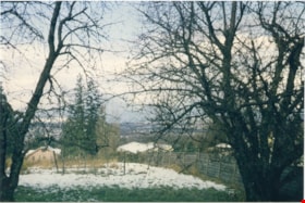
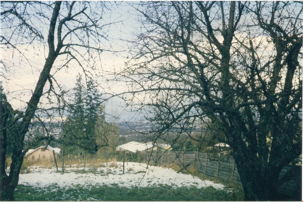
Back yard of the Mervin Mawhinney house looking north west
https://search.heritageburnaby.ca/link/museumdescription5208
- Repository
- Burnaby Village Museum
- Date
- 1962
- Collection/Fonds
- Reverend Edward S. Gale fonds
- Description Level
- Item
- Physical Description
- 1 photograph : col. ; 10 x 15.2 cm print
- Scope and Content
- Photograph of the back yard of the Mervin Mawhinney house looking north west. The ground is covered with snow. Two bare deciduous trees in foreground. The address of the house was 7661 Burris Street and was changed to 7667 Burris Street in 1984.
- Repository
- Burnaby Village Museum
- Collection/Fonds
- Reverend Edward S. Gale fonds
- Description Level
- Item
- Physical Description
- 1 photograph : col. ; 10 x 15.2 cm print
- Scope and Content
- Photograph of the back yard of the Mervin Mawhinney house looking north west. The ground is covered with snow. Two bare deciduous trees in foreground. The address of the house was 7661 Burris Street and was changed to 7667 Burris Street in 1984.
- Subjects
- Natural Phenomena - Snow
- Geographic Access
- Burris Street
- Street Address
- 7667 Burris Street
- Accession Code
- BV018.9.8
- Access Restriction
- No restrictions
- Reproduction Restriction
- May be restricted by third party rights
- Date
- 1962
- Media Type
- Photograph
- Planning Study Area
- Morley-Buckingham Area
- Scan Resolution
- 600
- Scan Date
- 07-05-2018
- Photographer
- Weller, Michael
- Notes
- Title based on contents of photograph
- "Dec. '62 / looking N. west" written in pen on verso.
Images
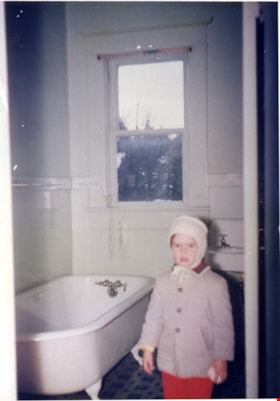
Bathroom of Mawhinney house
https://search.heritageburnaby.ca/link/museumdescription15568
- Repository
- Burnaby Village Museum
- Date
- 1962
- Collection/Fonds
- Reverend Edward S. Gale fonds
- Description Level
- Item
- Physical Description
- 1 photograph : col. negative ; 35 mm
- Scope and Content
- Photograph of the second floor bathroom inside of the Mervin Mawhinney house. Michael Weller's daughter is standing inside the bathroom with the bathtub to the left and the sink behind him. A pane glass window is on the wall above the bathtub. The address of the house was 7661 Burris Street and was…
- Repository
- Burnaby Village Museum
- Collection/Fonds
- Reverend Edward S. Gale fonds
- Description Level
- Item
- Physical Description
- 1 photograph : col. negative ; 35 mm
- Scope and Content
- Photograph of the second floor bathroom inside of the Mervin Mawhinney house. Michael Weller's daughter is standing inside the bathroom with the bathtub to the left and the sink behind him. A pane glass window is on the wall above the bathtub. The address of the house was 7661 Burris Street and was changed to 7667 Burris Street in 1984.
- Geographic Access
- Burris Street
- Street Address
- 7667 Burris Street
- Accession Code
- BV018.9.34
- Access Restriction
- No restrictions
- Reproduction Restriction
- May be restricted by third party rights
- Date
- 1962
- Media Type
- Photograph
- Planning Study Area
- Morley-Buckingham Area
- Scan Resolution
- 600
- Scan Date
- April 15, 2021
- Scale
- 100
- Photographer
- Weller, Michael
- Notes
- Title based on contents of photograph
- 1 col. print 12.5 x 9 cm accompanying
Images

![Burnaby Mountain, [between 1958 and 1965] (date of original), copied 1991 thumbnail](/media/hpo/_Data/_Archives_Images/_Unrestricted/370/370-797.jpg?width=280)
Burnaby Mountain
https://search.heritageburnaby.ca/link/archivedescription38210
- Repository
- City of Burnaby Archives
- Date
- [between 1958 and 1965] (date of original), copied 1991
- Collection/Fonds
- Burnaby Historical Society fonds
- Description Level
- Item
- Physical Description
- 1 photograph : b&w ; 3.2 x 5.1 cm print on contact sheet 20.5 x 26.8 cm
- Scope and Content
- Aerial photograph of Centennial Park, Burnaby Mountain and Burrard Inlet looking east.
- Repository
- City of Burnaby Archives
- Date
- [between 1958 and 1965] (date of original), copied 1991
- Collection/Fonds
- Burnaby Historical Society fonds
- Subseries
- Burnaby Image Bank subseries
- Physical Description
- 1 photograph : b&w ; 3.2 x 5.1 cm print on contact sheet 20.5 x 26.8 cm
- Description Level
- Item
- Record No.
- 370-797
- Access Restriction
- No restrictions
- Reproduction Restriction
- No restrictions
- Accession Number
- BHS1999-03
- Scope and Content
- Aerial photograph of Centennial Park, Burnaby Mountain and Burrard Inlet looking east.
- Subjects
- Aerial Photographs
- Geographic Features - Inlets
- Geographic Features - Mountains
- Geographic Features - Parks
- Media Type
- Photograph
- Notes
- Title based on contents of photograph
- 1 b&w copy negative accompanying
- Geographic Access
- Burnaby Mountain Conservation Area
- Planning Study Area
- Burnaby Mountain Area
Images
![Burnaby Mountain, [between 1958 and 1965] (date of original), copied 1991 thumbnail](/media/hpo/_Data/_Archives_Images/_Unrestricted/370/370-797.jpg)
![Burnaby Mountain Oil Storage, [1960] thumbnail](/media/hpo/_Data/_Archives_Images/_Unrestricted/001/109-001.jpg?width=280)
Burnaby Mountain Oil Storage
https://search.heritageburnaby.ca/link/archivedescription34704
- Repository
- City of Burnaby Archives
- Date
- [1960]
- Collection/Fonds
- Burnaby Historical Society fonds
- Description Level
- Item
- Physical Description
- 1 photograph : b&w ; 15.2 x 19.5 cm
- Scope and Content
- Aerial photograph of oil storage tanks on Burnaby Mountain, possibly those of Trans Mountain Oil Pipe Line Co. at the top of Underhill Avenue.
- Repository
- City of Burnaby Archives
- Date
- [1960]
- Collection/Fonds
- Burnaby Historical Society fonds
- Subseries
- Photographs subseries
- Physical Description
- 1 photograph : b&w ; 15.2 x 19.5 cm
- Description Level
- Item
- Record No.
- 109-001
- Access Restriction
- No restrictions
- Reproduction Restriction
- Reproduce for fair dealing purposes only
- Accession Number
- BHS2007-04
- Scope and Content
- Aerial photograph of oil storage tanks on Burnaby Mountain, possibly those of Trans Mountain Oil Pipe Line Co. at the top of Underhill Avenue.
- Media Type
- Photograph
- Notes
- Title based on contents of photograph
- Geographic Access
- Burnaby Mountain Conservation Area
- Shellmont Street
- Underhill Avenue
- Planning Study Area
- Lake City Area
Images
![Burnaby Mountain Oil Storage, [1960] thumbnail](/media/hpo/_Data/_Archives_Images/_Unrestricted/001/109-001.jpg)
![Burnaby Mountain's Centennial Pavilion, [between 1960 and 1979] thumbnail](/media/hpo/_Data/_Archives_Images/_Unrestricted/205/222-026.jpg?width=280)
Burnaby Mountain's Centennial Pavilion
https://search.heritageburnaby.ca/link/archivedescription36103
- Repository
- City of Burnaby Archives
- Date
- [between 1960 and 1979]
- Collection/Fonds
- Burnaby Historical Society fonds
- Description Level
- Item
- Physical Description
- 1 photograph : b&w ; 9 x 13.5 cm print
- Scope and Content
- Photograph of Burnaby Mountain's Centennial Pavilion, before it was rennovated to house the restaurant 'The Owl and the Oarsman'.
- Repository
- City of Burnaby Archives
- Date
- [between 1960 and 1979]
- Collection/Fonds
- Burnaby Historical Society fonds
- Subseries
- Columbian Newspaper subseries
- Physical Description
- 1 photograph : b&w ; 9 x 13.5 cm print
- Description Level
- Item
- Record No.
- 222-026
- Access Restriction
- No restrictions
- Reproduction Restriction
- Reproduce for fair dealing purposes only
- Accession Number
- BHS1989-19
- Scope and Content
- Photograph of Burnaby Mountain's Centennial Pavilion, before it was rennovated to house the restaurant 'The Owl and the Oarsman'.
- Subjects
- Buildings - Recreational
- Media Type
- Photograph
- Photographer
- King, Basil
- Notes
- Title based on contents of photograph
- Newspaper clipping glued to verso of photograph reads: "Burnaby centennial pavilion, built in 1958 at which time it was proposed that it would be used as a banquet hall, restaurant and tearoom, may become simply a restaurant under plans being considered by the parks and recreation commission. The parks commission plans to begin resevations about October of this year when the present tenants have vacated."
- Stamp on verso of photograph reads: "Basil King Photos"
- Geographic Access
- Centennial Way
- Burnaby Mountain Conservation Area
- Street Address
- 100 Centennial Way
- Planning Study Area
- Burnaby Mountain Area
Images
![Burnaby Mountain's Centennial Pavilion, [between 1960 and 1979] thumbnail](/media/hpo/_Data/_Archives_Images/_Unrestricted/205/222-026.jpg)
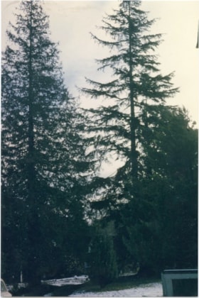
Cedar and hemlock trees
https://search.heritageburnaby.ca/link/museumdescription5214
- Repository
- Burnaby Village Museum
- Date
- Dec. 1962
- Collection/Fonds
- Reverend Edward S. Gale fonds
- Description Level
- Item
- Physical Description
- 1 photograph : col. ; 15.2 x 10.1 cm print
- Scope and Content
- Photograph of two large coniferous trees in the yard of the Mervin Mawhinney house. Some snowy ground in foreground. Overcast sky in background. The address of the house was 7661 Burris Street and was changed to 7667 Burris Street in 1984.
- Repository
- Burnaby Village Museum
- Collection/Fonds
- Reverend Edward S. Gale fonds
- Description Level
- Item
- Physical Description
- 1 photograph : col. ; 15.2 x 10.1 cm print
- Scope and Content
- Photograph of two large coniferous trees in the yard of the Mervin Mawhinney house. Some snowy ground in foreground. Overcast sky in background. The address of the house was 7661 Burris Street and was changed to 7667 Burris Street in 1984.
- Geographic Access
- Burris Street
- Street Address
- 7667 Burris Street
- Accession Code
- BV018.9.14
- Access Restriction
- No restrictions
- Reproduction Restriction
- May be restricted by third party rights
- Date
- Dec. 1962
- Media Type
- Photograph
- Planning Study Area
- Morley-Buckingham Area
- Scan Resolution
- 600
- Scan Date
- 07-05-2018
- Photographer
- Weller, Michael
- Notes
- Title based on contents of photograph
- "Dec. '62 / large cedar + hemlock at entrance" written in pen on verso.
Images

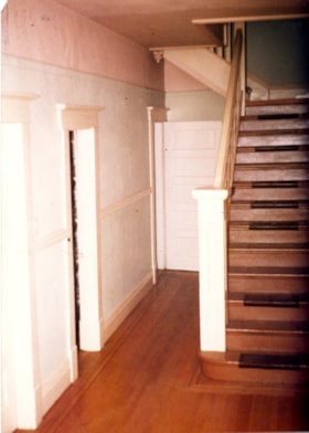
Entrance hall and stairway inside Mawhinney house
https://search.heritageburnaby.ca/link/museumdescription15574
- Repository
- Burnaby Village Museum
- Date
- 1962
- Collection/Fonds
- Reverend Edward S. Gale fonds
- Description Level
- Item
- Physical Description
- 1 photograph : col. ; 17.5 x 12.5 cm
- Scope and Content
- Photograph of the front entrance hall and stairway inside of the Mervin Mawhinney house. The address of the house was 7661 Burris Street and was changed to 7667 Burris Street in 1984.
- Repository
- Burnaby Village Museum
- Collection/Fonds
- Reverend Edward S. Gale fonds
- Description Level
- Item
- Physical Description
- 1 photograph : col. ; 17.5 x 12.5 cm
- Scope and Content
- Photograph of the front entrance hall and stairway inside of the Mervin Mawhinney house. The address of the house was 7661 Burris Street and was changed to 7667 Burris Street in 1984.
- Geographic Access
- Burris Street
- Street Address
- 7667 Burris Street
- Accession Code
- BV018.9.39
- Access Restriction
- No restrictions
- Reproduction Restriction
- May be restricted by third party rights
- Date
- 1962
- Media Type
- Photograph
- Planning Study Area
- Morley-Buckingham Area
- Scan Resolution
- 600
- Scan Date
- April 15, 2021
- Scale
- 100
- Photographer
- Weller, Michael
- Notes
- Title based on contents of photograph
Images

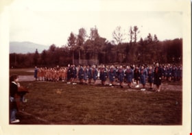
Girl guides on Burnaby mountain
https://search.heritageburnaby.ca/link/museumdescription15310
- Repository
- Burnaby Village Museum
- Date
- 1961
- Collection/Fonds
- Burnaby Girl Guides fonds
- Description Level
- Item
- Physical Description
- 1 photograph : col. ; 20.5 x 25.5 cm
- Scope and Content
- Photograph of a group of 5th Burnaby Brownies, Guides and their leaders from North Burnaby gathered together on Burnaby Mountain for the first outdoor "Scouts Own" and "Guides Own" Service since the early 1950s. Guides and Brownies from Burnaby Heights, Willingdon, HIllview and Sperling Guide Distr…
- Repository
- Burnaby Village Museum
- Collection/Fonds
- Burnaby Girl Guides fonds
- Description Level
- Item
- Physical Description
- 1 photograph : col. ; 20.5 x 25.5 cm
- Scope and Content
- Photograph of a group of 5th Burnaby Brownies, Guides and their leaders from North Burnaby gathered together on Burnaby Mountain for the first outdoor "Scouts Own" and "Guides Own" Service since the early 1950s. Guides and Brownies from Burnaby Heights, Willingdon, HIllview and Sperling Guide Districts and Rovers, Scouts and Cubs from Burnaby Heights, Burnaby Burrard and Burnaby Mountain Scout Districts gathered in the natural amphitheatre near the Pavillion, at two o'clock Sunday afternoon for the service.
- Geographic Access
- Burnaby Mountain Conservation Area
- Accession Code
- BV015.35.350
- Access Restriction
- No restrictions
- Reproduction Restriction
- May be restricted by third party rights
- Date
- 1961
- Media Type
- Photograph
- Planning Study Area
- Burnaby Mountain Area
- Scan Resolution
- 600
- Scan Date
- March 9, 2021
- Scale
- 100
- Notes
- Title based on contents of photograph
- Photograph is a part of original scrapbook "5th Brownie Pack" 1948-1965 Item BV015.35.156
- Information regarding event gathered from newspaper clipping with headline "Scouts, Guides / To Worship / Sunday Afternoon"
Images
