Narrow Results By
Decade
- 2020s 161
- 2010s 135
- 2000s 148
- 1990s 736
- 1980s 550
- 1970s 1640
- 1960s 466
- 1950s 645
- 1940s 895
- 1930s 981
- 1920s 744
- 1910s 586
- 1900s 386
- 1890s
- 1880s 32
- 1870s 13
- 1860s 16
- 1850s 10
- 1840s 5
- 1830s 2
- 1820s 2
- 1810s 2
- 1800s 2
- 1790s 2
- 1780s 2
- 1770s 2
- 1760s 2
- 1750s 2
- 1740s 2
- 1730s 2
- 1720s 2
- 1710s 2
- 1700s 2
- 1690s 2
- 1680s 2
- 1670s 2
- 1660s 2
- 1650s 2
- 1640s 2
- 1630s 2
- 1620s 2
- 1610s 2
- 1600s 2
- 1520s 1
Subject
- Adornment - Jewelry 2
- Agriculture - Farms 1
- Buildings - Commercial - Grocery Stores 1
- Buildings - Commercial - Stores 1
- Buildings Components - Fireplaces 1
- Buildings - Heritage 1
- Buildings - Industrial - Factories 1
- Buildings - Industrial - Saw Mills 1
- Buildings - Residential - Houses 2
- Celebrations - Jubilee 1
- Ceremonies - Graduations 1
- Clothing 5
![Threshing outfit in Burnaby on Fraser River, [1892] thumbnail](/media/hpo/_Data/_BVM_Images/2018/2018_0019_0002_001.jpg?width=280)
Threshing outfit in Burnaby on Fraser River
https://search.heritageburnaby.ca/link/museumdescription4776
- Repository
- Burnaby Village Museum
- Date
- [1892]
- Collection/Fonds
- Burnaby Village Museum Photograph collection
- Description Level
- Item
- Physical Description
- 1 photograph : b&w ; 8.9 x 8.9 cm ; copy print
- Scope and Content
- Threshing machine on paddlewheel barge on river. Five men standing on barge.
- Repository
- Burnaby Village Museum
- Collection/Fonds
- Burnaby Village Museum Photograph collection
- Description Level
- Item
- Physical Description
- 1 photograph : b&w ; 8.9 x 8.9 cm ; copy print
- Material Details
- "Ist Threshing outfit in Burnaby, about 1892. / Owned by Pat Byrne, brother of Peter. Sold to / Peter when Pat returned to Ireland to live. / ON Fraser River. L. to R. : Pat Byrne, Capt. Stewart / of "Alice", Peter Byrne and Another (unknown)." on typewritten label on front of photograph. "Columbian files" written on verso in black pen.
- Scope and Content
- Threshing machine on paddlewheel barge on river. Five men standing on barge.
- History
- Part of a set of photographs from the Columbian Newspaper, which operated out of New Westminster under this name starting in 1900 until its dissolution in 1988. Photographs found in the collection of the Burnaby Village are dated 1971.
- Other Title Information
- title based on note on front of photograph
- Names
- Byrne, Pat
- Accession Code
- BV018.19.2
- Access Restriction
- No restrictions
- Reproduction Restriction
- May be restricted by third party rights
- Date
- [1892]
- Media Type
- Photograph
- Scan Resolution
- 600
- Scan Date
- 24-04-2018
Images
![Threshing outfit in Burnaby on Fraser River, [1892] thumbnail](/media/hpo/_Data/_BVM_Images/2018/2018_0019_0002_001.jpg)
![Soldiers and nurse in front of a military tent, [1899 or 1900] thumbnail](/media/hpo/_Data/_BVM_Images/1974/197400470041.jpg?width=280)
Soldiers and nurse in front of a military tent
https://search.heritageburnaby.ca/link/museumdescription3059
- Repository
- Burnaby Village Museum
- Date
- [1899 or 1900]
- Collection/Fonds
- Burnaby Village Museum Photograph collection
- Description Level
- Item
- Physical Description
- 1 photograph : b&w ; 7.0 x 10.0 cm mounted on cardboard 12.6 x 15.9 cm
- Scope and Content
- Photograph of a group of unidentified soliders and an unidentified nurse standing in front of a military tent. Three men are seated on a bench, and three other men are standing behind them. One of the standing men is wounded and holding himself on crutches. An number "15" is in front of the tent…
- Repository
- Burnaby Village Museum
- Collection/Fonds
- Burnaby Village Museum Photograph collection
- Description Level
- Item
- Physical Description
- 1 photograph : b&w ; 7.0 x 10.0 cm mounted on cardboard 12.6 x 15.9 cm
- Scope and Content
- Photograph of a group of unidentified soliders and an unidentified nurse standing in front of a military tent. Three men are seated on a bench, and three other men are standing behind them. One of the standing men is wounded and holding himself on crutches. An number "15" is in front of the tent. According to the gift form signed by the donor, the photograph is thought to be taken in South Africa when when H. Niebergall was serving there.
- Accession Code
- HV974.47.41
- Access Restriction
- No restrictions
- Reproduction Restriction
- No known restrictions
- Date
- [1899 or 1900]
- Media Type
- Photograph
- Scan Resolution
- 600
- Scan Date
- 2023-04-25
- Notes
- Title based on contents of photograph
Images
![Soldiers and nurse in front of a military tent, [1899 or 1900] thumbnail](/media/hpo/_Data/_BVM_Images/1974/197400470041.jpg)
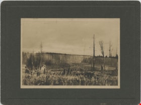
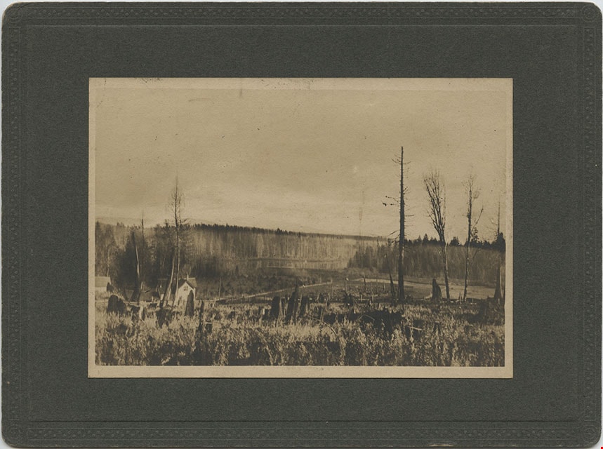
Looking from Woodlunds towards Burnaby Lake in 1899
https://search.heritageburnaby.ca/link/museumdescription992
- Repository
- Burnaby Village Museum
- Date
- 1899
- Collection/Fonds
- Burnaby Village Museum Photograph collection
- Description Level
- Item
- Physical Description
- 1 photograph : sepia photogravure ; 9.8 x 13.9 cm, mounted on cardboard 14.5 x 19.7 cm
- Scope and Content
- Photograph taken from "Woodlunds." Annotations in ink on the back of the card read, "Mr & Mrs G. Every-Clayton/ with Mr Haszard's/ wishes for a very/ Happy Xmas/ 1899" and "Looking from Woodlands / towards Burnaby Lake in 1899." Later annotation in blue ballpoint pen read, "Woodlunds the residence…
- Repository
- Burnaby Village Museum
- Collection/Fonds
- Burnaby Village Museum Photograph collection
- Description Level
- Item
- Physical Description
- 1 photograph : sepia photogravure ; 9.8 x 13.9 cm, mounted on cardboard 14.5 x 19.7 cm
- Scope and Content
- Photograph taken from "Woodlunds." Annotations in ink on the back of the card read, "Mr & Mrs G. Every-Clayton/ with Mr Haszard's/ wishes for a very/ Happy Xmas/ 1899" and "Looking from Woodlands / towards Burnaby Lake in 1899." Later annotation in blue ballpoint pen read, "Woodlunds the residence of Mr. Geo. Every-Clayton stood on the site of the present Centennial Pavilion, which when originally built was the residence of Mr. and Mrs. H.T. Ceperley. The proceeds from its sale was used to prepare the Ceperley playground in Stanley Park. The house in the left centre was that of Mr. and Mrs. Bernard R. Hill demolished to make way for entrance to Expressway."
- Names
- Every-Clayton, George
- Geographic Access
- Burnaby Lake
- Accession Code
- HV973.40.6
- Access Restriction
- No restrictions
- Reproduction Restriction
- No known restrictions
- Date
- 1899
- Media Type
- Photograph
- Scan Resolution
- 600
- Scan Date
- 2023-05-09
- Scale
- 100
- Notes
- Title based on contents of photograph
Images

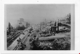
Aftermath of Great Fire of New Westminster, 1898
https://search.heritageburnaby.ca/link/museumdescription4781
- Repository
- Burnaby Village Museum
- Date
- 1898
- Collection/Fonds
- Burnaby Village Museum Photograph collection
- Description Level
- Item
- Physical Description
- 1 photograph : b&w ; 8.8 x 12.7 cm ; copy print
- Scope and Content
- Brick ruins of buildings on either side of a street with people, wagons and horses. Street runs top to bottom on left hand side of photograph.
- Repository
- Burnaby Village Museum
- Collection/Fonds
- Burnaby Village Museum Photograph collection
- Description Level
- Item
- Physical Description
- 1 photograph : b&w ; 8.8 x 12.7 cm ; copy print
- Material Details
- "Columbian files 1971" written on verso in black pen. ""FIRE" NEW WESTMINSTER SEPT. 1898." written on verso in pencil.
- Scope and Content
- Brick ruins of buildings on either side of a street with people, wagons and horses. Street runs top to bottom on left hand side of photograph.
- History
- Part of a set of photographs from the Columbian Newspaper, which operated out of New Westminster under this name starting in 1900 until its dissolution in 1988. Photographs found in the collection of the Burnaby Village are dated 1971.
- Other Title Information
- title based on content and note on verso of photograph
- Accession Code
- BV018.19.7
- Access Restriction
- No restrictions
- Reproduction Restriction
- May be restricted by third party rights
- Date
- 1898
- Media Type
- Photograph
- Scan Resolution
- 600
- Scan Date
- 24-04-2018
Images

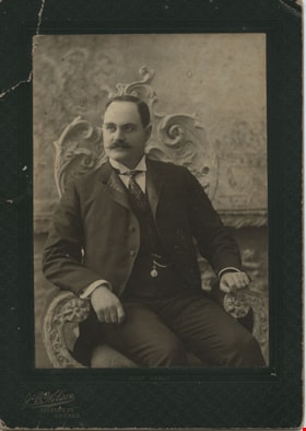
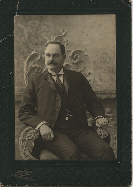
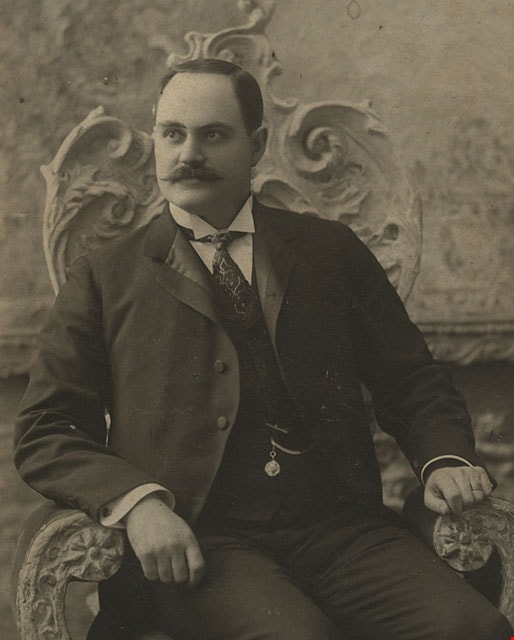
David M. McLean
https://search.heritageburnaby.ca/link/museumdescription392
- Repository
- Burnaby Village Museum
- Date
- December 1898
- Collection/Fonds
- Burnaby Village Museum Photograph collection
- Description Level
- Item
- Physical Description
- 1 photograph : b&w ; 13.34 x 18.42 cm
- Scope and Content
- Photograph of David M. McLean from Chicago, taken in a photographic studio. He is seated on a chair with floral motif backing. He has a moustache, and is wearing a suit with a vest with a pocket watch hanging from his vest pocket. His tie is patterned with strings and dots, and he is wearing cuffli…
- Repository
- Burnaby Village Museum
- Collection/Fonds
- Burnaby Village Museum Photograph collection
- Description Level
- Item
- Physical Description
- 1 photograph : b&w ; 13.34 x 18.42 cm
- Material Details
- printed on the card mount, recto, l.l. "J. B. Wilson/ 389 STATE ST./ CHICAGO", b. "BEST GRADE." inscribed in blue ink, verso, t. " "A Merry Xmas" 1898/ David M McLean/ Chicago"
- The photograph is mounted on a card supplied by the photo studio. The card mount is bent at u.l. corner
- Scope and Content
- Photograph of David M. McLean from Chicago, taken in a photographic studio. He is seated on a chair with floral motif backing. He has a moustache, and is wearing a suit with a vest with a pocket watch hanging from his vest pocket. His tie is patterned with strings and dots, and he is wearing cufflinks. His relationship to the donor and to Burnaby is not known.
- Names
- McLean, David M
- Accession Code
- HV983.42.132
- Reproduction Restriction
- No known restrictions
- Date
- December 1898
- Media Type
- Photograph
- Scan Resolution
- 600
- Scan Date
- 2023-11-21
- Photographer
- Wilson, J.B.
- Notes
- Title based on contents of photograph
Images

Map of South Western Part of British Columbia
https://search.heritageburnaby.ca/link/museumdescription8688
- Repository
- Burnaby Village Museum
- Date
- 1897
- Collection/Fonds
- Burnaby Village Museum Map collection
- Description Level
- Item
- Physical Description
- 1 map : col. ink on paper ; 68 x 88 cm
- Scope and Content
- Item consists of a "MAP OF THE SOUTH-WESTERN PART OF BRITISH COLUMBIA”. Map identifies geographic land districts of New Westminster District; Coast District; Lillooet District; Yale District, Kamloops Division, Yale Division and districts on Vancouver Island. Map also includes the northern portions…
- Repository
- Burnaby Village Museum
- Collection/Fonds
- Burnaby Village Museum Map collection
- Description Level
- Item
- Physical Description
- 1 map : col. ink on paper ; 68 x 88 cm
- Material Details
- Scale [1:633600]
- Scope and Content
- Item consists of a "MAP OF THE SOUTH-WESTERN PART OF BRITISH COLUMBIA”. Map identifies geographic land districts of New Westminster District; Coast District; Lillooet District; Yale District, Kamloops Division, Yale Division and districts on Vancouver Island. Map also includes the northern portions of the State of Washington below the 49th parallel.
- Publisher
- The Colonist Litho Victoria B.C.
- Responsibility
- Martin, George Bohun
- Accession Code
- BV993.12.12
- Access Restriction
- No restrictions
- Reproduction Restriction
- No known restrictions
- Date
- 1897
- Media Type
- Cartographic Material
- Scan Resolution
- 600
- Scan Date
- 2023-08-17
- Notes
- Transcribed title
- Scale equals 1 inch to 10 miles
- "Compiled and drawn by direction of the Honouable G.B. Martin, Chief Commissioner of Lands and Works, Victoria, B.C."
- Signed by Surveyor General "Tom Kains"
Zoomable Images

![Douglas Road, [1897] (date of original), copied 1978 thumbnail](/media/hpo/_Data/_BVM_Images/1978/1978_0001_0001_001.jpg?width=280)
Douglas Road
https://search.heritageburnaby.ca/link/museumdescription447
- Repository
- Burnaby Village Museum
- Date
- [1897] (date of original), copied 1978
- Collection/Fonds
- Burnaby Village Museum Photograph collection
- Description Level
- Item
- Physical Description
- 1 photograph : b&w ; 20.2 x 25.2 cm print
- Scope and Content
- Photograph of Douglas Road (later renamed in part Canada Way), near Stanley Street. To the right is the Sprott family property, where a few wooden buildings are visible in the cleared area. Charles Sprott, head of the Sprott family, was an important Burnaby politician who was continuously elected t…
- Repository
- Burnaby Village Museum
- Collection/Fonds
- Burnaby Village Museum Photograph collection
- Description Level
- Item
- Physical Description
- 1 photograph : b&w ; 20.2 x 25.2 cm print
- Scope and Content
- Photograph of Douglas Road (later renamed in part Canada Way), near Stanley Street. To the right is the Sprott family property, where a few wooden buildings are visible in the cleared area. Charles Sprott, head of the Sprott family, was an important Burnaby politician who was continuously elected to serve in the municiality as councillor from 1895 to 1903 and as Reeve from 1904 to 1905.
- Subjects
- Geographic Features - Roads
- Land Clearing
- Geographic Access
- Douglas Road
- Canada Way
- Stanley Street
- Accession Code
- HV978.1.1
- Access Restriction
- No restrictions
- Reproduction Restriction
- No known restrictions
- Date
- [1897] (date of original), copied 1978
- Media Type
- Photograph
- Historic Neighbourhood
- Burnaby Lake (Historic Neighbourhood)
- Planning Study Area
- Lakeview-Mayfield Area
- Scan Resolution
- 600
- Scan Date
- 2023-07-25
- Notes
- Title based on contents of photograph
Images
![Douglas Road, [1897] (date of original), copied 1978 thumbnail](/media/hpo/_Data/_BVM_Images/1978/1978_0001_0001_001.jpg)
![B.C. Sugar Refinery Picnic, [1897] thumbnail](/media/hpo/_Data/_BVM_Images/1976/1976_0036_0029_001.jpg?width=280)
B.C. Sugar Refinery Picnic
https://search.heritageburnaby.ca/link/museumdescription667
- Repository
- Burnaby Village Museum
- Date
- [1897]
- Collection/Fonds
- Burnaby Village Museum Photograph collection
- Description Level
- Item
- Physical Description
- 1 photograph : b&w ; 17 x 38 cm
- Scope and Content
- Photograph of a large group picnic. Banners tied between two trees behind the group read "B.C.S.[last letter obscured by an individual] 6th ANNUAL PICNIC" and "ROGERS' GOLDEN SYRUP." It is speculated that this photograph is of the British Columbia Sugar Refining Company's (sixth annual) picnic.
- Repository
- Burnaby Village Museum
- Collection/Fonds
- Burnaby Village Museum Photograph collection
- Description Level
- Item
- Physical Description
- 1 photograph : b&w ; 17 x 38 cm
- Scope and Content
- Photograph of a large group picnic. Banners tied between two trees behind the group read "B.C.S.[last letter obscured by an individual] 6th ANNUAL PICNIC" and "ROGERS' GOLDEN SYRUP." It is speculated that this photograph is of the British Columbia Sugar Refining Company's (sixth annual) picnic.
- Subjects
- Recreational Activities - Picnics
- Accession Code
- HV976.36.29
- Access Restriction
- No restrictions
- Reproduction Restriction
- No known restrictions
- Date
- [1897]
- Media Type
- Photograph
- Scan Resolution
- 300
- Scan Date
- 17/8/2006
- Scale
- 100
- Photographer
- Dominion Photo Studio
- Notes
- Title based on contents of photograph
Images
![B.C. Sugar Refinery Picnic, [1897] thumbnail](/media/hpo/_Data/_BVM_Images/1976/1976_0036_0029_001.jpg)
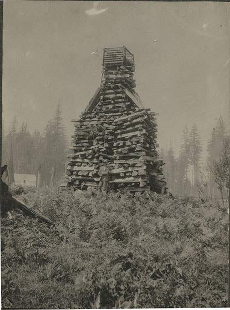
![Claude Hill in front of log pile, [1897] thumbnail](/media/hpo/_Data/_BVM_Images/1973/1973_0040_0002_001.jpg?width=280)
Claude Hill in front of log pile
https://search.heritageburnaby.ca/link/museumdescription989
- Repository
- Burnaby Village Museum
- Date
- [1897]
- Collection/Fonds
- Burnaby Village Museum Photograph collection
- Description Level
- Item
- Physical Description
- 1 photograph : sepia ; 9.6 x 7.1 cm mounted on cardboard 14.9 x 12.5 cm
- Scope and Content
- Photograph of a large stack of wood prepared for a bonfire on a hill. The bonfire stack is towering over a man who stands in front of it with his arms crossed and wearing a hat. There is a house seen in the background to the left of the photograph. The photograph is identified by the acquisition…
- Repository
- Burnaby Village Museum
- Collection/Fonds
- Burnaby Village Museum Photograph collection
- Description Level
- Item
- Physical Description
- 1 photograph : sepia ; 9.6 x 7.1 cm mounted on cardboard 14.9 x 12.5 cm
- Scope and Content
- Photograph of a large stack of wood prepared for a bonfire on a hill. The bonfire stack is towering over a man who stands in front of it with his arms crossed and wearing a hat. There is a house seen in the background to the left of the photograph. The photograph is identified by the acquisition record and inscription on the back as Queen Victoria's Jubilee bonfire. There is a discrepancy in the records as to who the man is. Some have identified him as Bernard Hill, others, as Mr. L.C. Hill. An annotation on th back of the photo reads, "1897/ Queen Victorias Jubilee/ Bonfire prepared by Mr LC Hill/ just above what is now Deer/ Lake Ave and below the/ present Centennial Pavilion."
- Subjects
- Celebrations - Jubilee
- Geographic Access
- Deer Lake
- Accession Code
- HV973.40.2
- Access Restriction
- No restrictions
- Reproduction Restriction
- No known restrictions
- Date
- [1897]
- Media Type
- Photograph
- Historic Neighbourhood
- Burnaby Lake (Historic Neighbourhood)
- Related Material
- For another photograph of the bonfire prepared by L. C. Hill, see photograph HV976.139.49
- Scan Resolution
- 600
- Scan Date
- 2023-05-09
- Scale
- 100
- Notes
- Title based on contents of photograph
Images
![Claude Hill in front of log pile, [1897] thumbnail](/media/hpo/_Data/_BVM_Images/1973/1973_0040_0002_001.jpg)
![Brookfield, [1896] thumbnail](/media/hpo/_Data/_BVM_Images/1973/1973_0040_0001_001.jpg?width=280)
Brookfield
https://search.heritageburnaby.ca/link/museumdescription988
- Repository
- Burnaby Village Museum
- Date
- [1896]
- Collection/Fonds
- Burnaby Village Museum Photograph collection
- Description Level
- Item
- Physical Description
- 1 photograph : b&w ; 12.1 x 17.7 cm
- Scope and Content
- Photograph of the house built about 1894 that Louis Claud Hill called "Brookfield." Mr. Hill was married that year to Annie Sara Kendrick, and they took up residence in the house until 1906 when they sold the property and built a new home in the vicinity of Buckingham and Sperling. Brookfield was…
- Repository
- Burnaby Village Museum
- Collection/Fonds
- Burnaby Village Museum Photograph collection
- Description Level
- Item
- Physical Description
- 1 photograph : b&w ; 12.1 x 17.7 cm
- Scope and Content
- Photograph of the house built about 1894 that Louis Claud Hill called "Brookfield." Mr. Hill was married that year to Annie Sara Kendrick, and they took up residence in the house until 1906 when they sold the property and built a new home in the vicinity of Buckingham and Sperling. Brookfield was still on the property when the Burnaby Village Museum was planned in 1971 as Heritage Village, but it was torn down to make room for other buildings on the site. An acquisition record notes that this house stood immediately behind the Elworth House, and Colonel Peers' (the donor) mother was born in this house in 1898. Annotations on the back of the photo read, "1896 'Brookfield'" and "The residence of Mr.+Mrs. LC Hill, the first residence on the site of Heritage Court. It stood immediately behind what is now called the Manor House. Built about 1894."
- Subjects
- Buildings - Residential - Houses
- Geographic Access
- Deer Lake Avenue
- Street Address
- 6501 Deer Lake Avenue
- Accession Code
- HV973.40.1
- Access Restriction
- No restrictions
- Reproduction Restriction
- No known restrictions
- Date
- [1896]
- Media Type
- Photograph
- Historic Neighbourhood
- Burnaby Lake (Historic Neighbourhood)
- Planning Study Area
- Morley-Buckingham Area
- Scan Resolution
- 600
- Scan Date
- 2023-05-09
- Scale
- 100
- Notes
- Title based on contents of photograph
Images
![Brookfield, [1896] thumbnail](/media/hpo/_Data/_BVM_Images/1973/1973_0040_0001_001.jpg)
Affidavit certificate re H.A. Eastman, Jessie Love and J.E. Armstrong
https://search.heritageburnaby.ca/link/museumdescription18802
- Repository
- Burnaby Village Museum
- Date
- 9 Feb. 1894
- Collection/Fonds
- Love family fonds
- Description Level
- Item
- Physical Description
- 1 p. of textual records
- Scope and Content
- Item consists of an affidavit certificate re H.A. Eastman, Jesse Love and J.C. Armstrong signed by Commissioner for taking affidavits to be used in the Supreme Court of British Columbia.
- Repository
- Burnaby Village Museum
- Collection/Fonds
- Love family fonds
- Description Level
- Item
- Physical Description
- 1 p. of textual records
- Scope and Content
- Item consists of an affidavit certificate re H.A. Eastman, Jesse Love and J.C. Armstrong signed by Commissioner for taking affidavits to be used in the Supreme Court of British Columbia.
- Accession Code
- BV992.26.22
- Access Restriction
- No restrictions
- Reproduction Restriction
- No known restrictions
- Date
- 9 Feb. 1894
- Media Type
- Textual Record
- Notes
- Title based on contents of item
- Certificate, blue paper with black print, blank areas filled in with handwriting in brown ink; "I hereby certify that" "H.A. Eastman" "personally known to me, appeared before me and acknowledged to me that" "he" "the person whose name is subscribed to the annexed Instrument as Witness, and having been duly sworn by me, did prove to me that" "Jesse Love & J.C. Armstrong" "did execute the same in his presence voluntarily." "IN TESTIMONY whereof, I have hereto set my Hand and Seal of Office, at" "New Westminster" ", British Columbia, this" "9th" "day of" "February" "in the year of Our Lord one thousand eight hundred and ninety-" "four"; signed in black ink, "J. Brisere Cheny"?; stamped purple "A Commissioner for taking affidavits to be used in the Supreme Court of British Columbia".
Description of Mr. Love's Property
https://search.heritageburnaby.ca/link/museumdescription18804
- Repository
- Burnaby Village Museum
- Date
- [1894]
- Collection/Fonds
- Love family fonds
- Description Level
- Item
- Physical Description
- 1 p. of textual records
- Scope and Content
- Item consists of a document titled "Description of Mr. Love's Property". The document describes Jesse Love's property located at the north east corner of District Lot 25 located on Cumberland Road in Burnaby.
- Repository
- Burnaby Village Museum
- Collection/Fonds
- Love family fonds
- Description Level
- Item
- Physical Description
- 1 p. of textual records
- Scope and Content
- Item consists of a document titled "Description of Mr. Love's Property". The document describes Jesse Love's property located at the north east corner of District Lot 25 located on Cumberland Road in Burnaby.
- Accession Code
- BV992.26.24
- Access Restriction
- No restrictions
- Reproduction Restriction
- No known restrictions
- Date
- [1894]
- Media Type
- Textual Record
- Notes
- Transcribed title
- Document, buff paper, legal-sized, typed in black carbon; "DESCRIPTION OF MR. LOVE'S PROPERTY" at top, underlined; "Commencing at a post at the north-east corner of lot twenty-five (25); thence southerly along the westerly line of the Cumberland Road thirty-four (34) chains and eighty-four (84) links; thence westerly and parallel with the line between/ district lots twenty-five (25) and eighty-eight (88) fourteen (14) chains and fifty (50) links thence northerly and parallel with the Cumberland Road thirty-four (34) chains and eighty-four (84) links thence eatserly along the line between said lots twenty-five and eighty eight (88) to point of commencement containing fifty and five hundred and eighteen thousandths (50.518) acres more or less" [NOTE "eatserly" is as written on document]
- watermark "WESTMINSTER BOND"; pencilled on reverse, "63 - 00", line, "31 1-0" and six short marks like checks
![Jesse and Martha Love farmhouse, [between 1893 and 1905] (date of original), copied [1988] thumbnail](/media/hpo/_Data/_BVM_Images/1985/1985_3136_0001_001.jpg?width=280)
Jesse and Martha Love farmhouse
https://search.heritageburnaby.ca/link/museumdescription2999
- Repository
- Burnaby Village Museum
- Date
- [between 1893 and 1905] (date of original), copied [1988]
- Collection/Fonds
- Love family fonds
- Description Level
- Item
- Physical Description
- 1 photograph : b&w print ; 9 x 13 cm print
- Scope and Content
- Photograph of the south side of Love Farmhouse prior to the addition of the kitchen. The Love farmhouse was built in 1893 by Jesse Love and was located at 1390 Cumberland Road at the corner of 14th Avenue (after 1960- address was changed to 7651 Cumberland Street). The Love farmhouse was relocated …
- Repository
- Burnaby Village Museum
- Collection/Fonds
- Love family fonds
- Description Level
- Item
- Physical Description
- 1 photograph : b&w print ; 9 x 13 cm print
- Scope and Content
- Photograph of the south side of Love Farmhouse prior to the addition of the kitchen. The Love farmhouse was built in 1893 by Jesse Love and was located at 1390 Cumberland Road at the corner of 14th Avenue (after 1960- address was changed to 7651 Cumberland Street). The Love farmhouse was relocated to the site of the Burnaby Village Museum in 1988 where it was restored to the 1920s era.
- Subjects
- Buildings - Heritage
- Geographic Access
- Cumberland Street
- Street Address
- 7651 Cumberland Street
- Accession Code
- BV985.3136.1
- Access Restriction
- No restrictions
- Reproduction Restriction
- No known restrictions
- Date
- [between 1893 and 1905] (date of original), copied [1988]
- Media Type
- Photograph
- Historic Neighbourhood
- East Burnaby (Historic Neighbourhood)
- Planning Study Area
- Cariboo-Armstrong Area
- Scan Resolution
- 600
- Scan Date
- 16-Jan-24
- Notes
- Title based on content of photograph
- Label on front of photograph reads: "Old home side"
- Label beneath photograph in original album reads:" Old home field"
- 1 b&w copy negative accompanying
Images
![Jesse and Martha Love farmhouse, [between 1893 and 1905] (date of original), copied [1988] thumbnail](/media/hpo/_Data/_BVM_Images/1985/1985_3136_0001_001.jpg)
Jesse Love farmhouse series
https://search.heritageburnaby.ca/link/museumdescription9782
- Repository
- Burnaby Village Museum
- Date
- [1893-1970] (date of originals), copied 1988-1998, predominant 1988-2000
- Collection/Fonds
- Burnaby Village Museum fonds
- Description Level
- Series
- Physical Description
- approx. 84 cm of textual records + approx. 1,910 photographs + approx. 100 architectural drawings + 3 audio cassettes + 1 videocassette
- Scope and Content
- Series consists of records involved in the purchase, moving, restoration, research, conservation and exhibiting of the Love family farmhouse by Burnaby Village Museum. Records have been arranged into the following subseries: 1) Love farmhouse conservation work files subseries 2) Love farmhouse re…
- Repository
- Burnaby Village Museum
- Collection/Fonds
- Burnaby Village Museum fonds
- Series
- Jesse Love farmhouse series
- Description Level
- Series
- Physical Description
- approx. 84 cm of textual records + approx. 1,910 photographs + approx. 100 architectural drawings + 3 audio cassettes + 1 videocassette
- Scope and Content
- Series consists of records involved in the purchase, moving, restoration, research, conservation and exhibiting of the Love family farmhouse by Burnaby Village Museum. Records have been arranged into the following subseries: 1) Love farmhouse conservation work files subseries 2) Love farmhouse restoration photographs subseries 3) Love farmhouse curatorial files subseries 4) Love farmouse research files subseries 5) Love family photographs 6) Love farmhouse Oral History subseries 7) Love farmhouse architectural drawings subseries
- History
- Jesse Love was born in Swindon, England in 1847 and left England to work on a dairy farm in the Toronto area. While working on the farm in Toronto, he met Martha Leonard who he married in 1879. Martha was born on February 3, 1858 in Bedfordshire, England and had come to Canada with her parents George and Ann Leonard. While living in Toronto, Jesse and Martha had two children, George born March 22, 1880 and Annie Elizabeth on August 24, 1881. About one year after Annie was born, the Love family moved to North Dakota to grow wheat. While living there, they had two more children, Henry who was born August 24, 1883 and Edith Minnie born October 9, 1885. The family decided to move further west after hearing about the fairer weather conditions from Martha’s father, George Leonard, who had settled in Vancouver in 1885. On May 23, 1887, Jesse, Martha and their four children arrived in Vancouver after travelling across Canada from Winnipeg on the first transcontinental train. The Loves made their home in Vancouver while Jesse helped clear land on Granville Street. Their fifth child, Thomas Robert was born on September 17, 1887 and soon after, the family moved to Lulu Island in Richmond where they lived growing vegetables and selling them to Vancouver hotels. While living and farming on Lulu island, the couple had two more girls, Martha (Dot or Dorothy) born on December 17, 1889 and Sarah Marie, born February 8, 1892. On October 6, 1893 an agreement was signed by Jesse Love to purchase 14.52 acres of land from Joseph C. Armstrong. The acreage covered the north east section of District Lot 25 within the newly incorporated District of the Municipality of Burnaby. It was here where the original Love house was built (between October 1893 and April 15, 1894) by Jesse Love with the help of local builder George Salt and father in law, George Leonard. The house consisted of an entrance hall, dining room, lean to kitchen, master bedroom and three bedrooms upstairs. A road was constructed and named Cumberland in 1905 and ran from District Lot 25 through to District Lot 11. The address for the Love home was 1390 Cumberland Road and in the early 1960’s the address was renumbered 7651 Cumberland Street. On the land surrounding the house, Jesse Love planted an orchard along with strawberries and raspberries which he sold at the Fraser Valley Market, T.S. Anandale’s Grocery Store in New Westminster and to hotels around Vancouver. Jesse Love served on the Burnaby School Board and also as a District Councillor in 1901 and from 1904-1907. While living in the house, Jesse and Martha had four more children, Phoebe Leonard, born April 15, 1894, Esther, born August 28, 1896, John Leonard, born June 7, 1899 and Hannah Victoria (also known as Girlie) who was born May 12, 1902. As the family grew to eleven children, additions along with some substantial remodelling in the craftsman style took place. In about 1898, a north wing addition was added to include a parlour with two windows, the construction of two more bedrooms and the relocation of the stair case to the North West wall. In 1903 the front door moved to the north elevation, a front porch was extended along the east wall and a summer lean to kitchen was added to the west elevation. Between 1905 and 1910, a tin embossed ceiling was installed along with an addition of the main kitchen which included a pantry, bathtub and a back porch. In about 1912, five craftsman style windows replaced the original pioneer tent style, the front verandah was enlarged to wrap around the south and east elevations, a back door was installed in the kitchen to access the verandah and wood shingle siding and brackets were added to the exterior. In 1918, at the age of 31 years, Robert Love fell ill due to an influenza epidemic and died on November 23, 1918. Following their son’s death, Martha Love became weak and on August 24, 1920, she passed away. By this time, Jesse had sold off a large percentage of his land and his youngest daughter, Girlie decided to stay on to live and care for him. Since the house was too large for just the two of them, Jesse invited any other children to return and share the residence. For a while his son, George and his wife joined them until 1925, followed by his daughter Sarah Parker (nee Love), her husband William and their three children, Albert, Bill and Elsie. The house remained pretty unchanged until 1928 after Jesse Love died of pneumonia (March 10, 1928) and the house was purchased by Sarah and her husband William Parker who continued to live there with their children. The master bedroom wall on the main floor opened up to the dining room, the kitchen pantry and bathtub converted to an alcove with a marble counter and enlarged window and sink while the bathroom was moved to the upstairs and the furnace and coolers were installed in the crawl space under the kitchen. A hot water tank was installed in the house in 1966. Sarah continued to live in the house until a little while after her husband William died in 1961. She sold the house to her daughter Elsie and husband John Hughes in 1966, who lived in the house along with their son Brent, until August 23, 1971. Mahbir Molchan Papan and his wife Geraldine Papan bought the house August 23, 1971 and by 1982, the house was sold to Nirmal Singh Singha and Narinder Singha. The Papans continued to rent the house from Nirmal Singh Singha and Narinder Singha until the late 1980s. In 1988, the house was scheduled for demolition with the remaining property to be subdivided. Fortunately, a neighbour, Mr. Harvey Elder recognized the farmhouse's historical significance and contacted the Burnaby Historical Society. Following this event, the owners agreed to donate the building to the Burnaby Village Museum (under the Century Park Museum Association) who financed the move of the house from Cumberland Street to the museum site. Heritage planner and architect, Robert Lemon provided guidance for the project. Prior to the move, the two porches were removed and demolished while the kitchen and roof were both separated from the main house. The kitchen and roof of the house were transported to Burnaby Village Museum on May 20, 1988 by Nickel Bros. House Moving company, while the main frame of the house completed its transportation to the museum near the end of May 1988 (due to low overhead wires). The house was moved down Cumberland Street to 10th Avenue, up Canada Way to Sperling and set on temporary footings near Hart House. Robert Lemon oversaw structural improvements such as, upgrading floor joists and creating new foundations to replace the original timber foundation of the farmhouse. The restoration went through several phases of work between 1988 until it opened in November 1998. Restoration began on both the interior and exterior features to be interpreted from the period of 1925. On November 23, 1992, the building was designated a heritage building under Heritage Designation Bylaw 1992, Bylaw Number 9807. In 1993, the architecture firm of Brian G. Hart Associates was appointed for the design and construction supervision of the restoration project. Plans were created for a foundation on the museum site in 1989 and the farmhouse was eventually settled on a permanent foundation behind the Burnaby Village Museum administration building in 1993 along with the reattachment of the roof. The kitchen section was reattached to the main house in 1994 along with skirting around the foundation and the reshingling of the exterior. In 1996, the tin ceiling was removed to make way for the installation of the internal electrical system along with sprinklers, ceiling heating and fire break gyprock. The dining room ceiling joists were consolidated, a pantry and bathroom were added to the kitchen, the downstairs bedroom wall was opened and filled, the dining and kitchen doorways were widened. In 1997, a wheelchair ramp was installed along with a concrete sidewalk, stair rails, cement pads at the base of the stairs and a gravel sink for any excess water. Interior work included painting of the kitchen, restoration and furnishing of the kitchen pantry, insulation of the house floor to protect from rodents along with the reconstruction of the kitchen and house chimneys. The registrar worked together with the curator and conservator and was tasked with a large research project on the house including the family contacts and family history, property information, plans, photographs, artifacts, furnishings, stories etc. all organized in files for easy retrieval. A great deal of research and conservation was undertaken in order to make the interior of the house authentic to the time period as possible. One of the biggest projects was selecting and obtaining wall coverings since much of the original wallpaper was incomplete and poor condition. The conservator and registrar were lucky enough to locate a few samples of the original paper and engage the Bradbury and Bradbury Art Wallpaper Company of Benica, California to reproduce replica designs for free. The City of Burnaby now has its own series “Burnaby Village Papers” produced by this company which are titled “Burnaby Wall”; “Burnaby Border” and “Burnaby Ceiling”. All three of these wallpaper designs have been used in the Love farm house and are also commercially available through the Bradbury and Bradbury Art Wallpaper Company. In 1997, restoration of the kitchen was completed and opened to the public. After the completion of the dining room, main floor bedroom and parlour, the Love farmhouse exhibit opened on November 29, 1998 with an open invitation to the public and extended members of the Love family. Officials including the Mayor, Doug Drummond and Love family members were all present to cut the ribbon for the special event.
- Accession Code
- BV018.41; BV020.5
- Access Restriction
- Restricted access
- Date
- [1893-1970] (date of originals), copied 1988-1998, predominant 1988-2000
- Arrangement
- The majority of the records within series and subseries were arranged by a staff members of Burnaby Village Museum who worked on the historical research and restoration of the house. Other photographs documenting the move and further restoration work were added later and included in the arrangment by format and subject.
- Notes
- Title based on content of series
- Jesse Love farmhouse is described as an Artifact under BV988.33.1
- Some records within this collection have restricted access and are subject to FIPPA
- Accessions BV018.41 and BV020.5 form this fonds
Deed of Land Sale - fragment
https://search.heritageburnaby.ca/link/museumdescription10089
- Repository
- Burnaby Village Museum
- Date
- [1893]
- Collection/Fonds
- Love family fonds
- Description Level
- Item
- Physical Description
- 1 p. of textual records
- Scope and Content
- Item consists of the bottom portion of a Deed of Land Sale. It contains a hand written, legal description of property which reads: "Cumberland Road in Lot 25, G. 1, N.W. Dist the / same being distant 14.18 Chs. S. 63.30 (degrees) E, from / the Northeast corner of said Lot 25; thense S. 63.30 E....a…
- Repository
- Burnaby Village Museum
- Collection/Fonds
- Love family fonds
- Description Level
- Item
- Physical Description
- 1 p. of textual records
- Scope and Content
- Item consists of the bottom portion of a Deed of Land Sale. It contains a hand written, legal description of property which reads: "Cumberland Road in Lot 25, G. 1, N.W. Dist the / same being distant 14.18 Chs. S. 63.30 (degrees) E, from / the Northeast corner of said Lot 25; thense S. 63.30 E....and containing by estimaton ten (10) acres...".
- History
- See extensive history of Love Family and Love farmhouse located at Burnaby Village Museum.
- Accession Code
- BV012.31.21
- Access Restriction
- No restrictions
- Reproduction Restriction
- No known restrictions
- Date
- [1893]
- Media Type
- Textual Record
- Notes
- Title based on content of file
Agreement for sale of land between Joseph C. Armstrong and Jesse Love re District Lot 25
https://search.heritageburnaby.ca/link/museumdescription18788
- Repository
- Burnaby Village Museum
- Date
- 6 Oct. 1893
- Collection/Fonds
- Love family fonds
- Description Level
- Item
- Physical Description
- 1 p. of textual records + 1 plan : red and black ink on linen ; 16 x 8.5 cm
- Scope and Content
- Item consists of an Agreement for Sale of Land dated October 6, 1893 between Joseph C. Armstrong and Jesse Love for District Lot 25, Group one, New Westminster District and a small hand drawn plan showing District Lot 25, Cumberland Road and location of building. Land Agreement was registered Febru…
- Repository
- Burnaby Village Museum
- Collection/Fonds
- Love family fonds
- Description Level
- Item
- Physical Description
- 1 p. of textual records + 1 plan : red and black ink on linen ; 16 x 8.5 cm
- Scope and Content
- Item consists of an Agreement for Sale of Land dated October 6, 1893 between Joseph C. Armstrong and Jesse Love for District Lot 25, Group one, New Westminster District and a small hand drawn plan showing District Lot 25, Cumberland Road and location of building. Land Agreement was registered February 13, 1894.
- Accession Code
- BV992.26.8
- Access Restriction
- No restrictions
- Reproduction Restriction
- No known restrictions
- Date
- 6 Oct. 1893
- Media Type
- Textual Record
- Cartographic Material
- Notes
- Title based on contents of item
- Document dated Oct 6 1893; "ARTICLES OF AGREEMENT" between Joseph C. Armstrong and Jesse Love; one page, folded on buff, legal-sized paper with pink borders; black print; handwritten in faded brown ink; for a parcel of land in the New Westminster District, all that portion of Lot 25, Group I, from a point on the Easterly side 20 chains from the South Easterly corner, then from the South Easterly corner, then northerly and parallel with the Cumberland Road for 10 chains and 52 links, then southerly 10 chains, then Easterly 14 chains and 52 links, total 14 acres and 52/100; for $1161 in 17 instalments at 6% interest; signed by Jesse Love and J.C. Armstrong, witnessed by H.A. Eastman; two seals are missing, pink stains on paper; addition May 1900 signed by Jesse Love and H.A. Eastman; folds twice; when folded, panel showing is "AGREEMENT for Sale of Land." "on Cumberland road in Lot 25 Group I"; handwritten "H.A. Eastman" over printed "E.H. PORT & CO.", "REAL ESTATE BROKERS" "NEW WESTMINSTER BRITISH COLUMBIA"; back panel has blue stamping and pink additions, giving No. 546C, registered February 13, 1894, Charge Book Vol. 13, Folio 51, signed C.S. Corrigan? District Registrar; with hand-drawn plan on stained linen, pink ink with black additions, shows Cumberland Road and city limits.
Love and Leonard land records series
https://search.heritageburnaby.ca/link/museumdescription18838
- Repository
- Burnaby Village Museum
- Date
- 1893-1962
- Collection/Fonds
- Love family fonds
- Description Level
- Series
- Physical Description
- 5 plans + 8 cm of textual records
- Scope and Content
- Series consists of land deeds, land sale agreements, documents regarding payment and survey and subdivision plans. Records refer to the Love family property in District Lot 25, the Leonard family property in District Lot 352 and other lots in Burnaby.
- Repository
- Burnaby Village Museum
- Collection/Fonds
- Love family fonds
- Description Level
- Series
- Physical Description
- 5 plans + 8 cm of textual records
- Scope and Content
- Series consists of land deeds, land sale agreements, documents regarding payment and survey and subdivision plans. Records refer to the Love family property in District Lot 25, the Leonard family property in District Lot 352 and other lots in Burnaby.
- Accession Code
- BV992.26
- BV012.31
- Date
- 1893-1962
- Media Type
- Textual Record
- Cartographic Material
- Notes
- Title based on contents of series
![Jesse Love farmhouse, [between 1893 and 1897] (date of original), copied 1998 thumbnail](/media/hpo/_Data/_BVM_Images/2000/200000450002.jpg?width=280)
Jesse Love farmhouse
https://search.heritageburnaby.ca/link/museumdescription1551
- Repository
- Burnaby Village Museum
- Date
- [between 1893 and 1897] (date of original), copied 1998
- Collection/Fonds
- Love family fonds
- Description Level
- Item
- Physical Description
- 1 photograph : b&w ; 19 x 25 cm print
- Scope and Content
- Photograph of the Jesse Love farmhouse. The Love farmhouse was located at 1390 Cumberland Road (after 1960- address was changed to 7651 Cumberland Street). The Love farmhouse was relocated to the site of the Burnaby Village Museum in 1988 where it was restored to the 1920s era.
- Repository
- Burnaby Village Museum
- Collection/Fonds
- Love family fonds
- Description Level
- Item
- Physical Description
- 1 photograph : b&w ; 19 x 25 cm print
- Scope and Content
- Photograph of the Jesse Love farmhouse. The Love farmhouse was located at 1390 Cumberland Road (after 1960- address was changed to 7651 Cumberland Street). The Love farmhouse was relocated to the site of the Burnaby Village Museum in 1988 where it was restored to the 1920s era.
- Subjects
- Buildings - Residential - Houses
- Geographic Access
- Cumberland Street
- Street Address
- 7651 Cumberland Street
- Accession Code
- BV000.45.2
- Access Restriction
- No restrictions
- Date
- [between 1893 and 1897] (date of original), copied 1998
- Media Type
- Photograph
- Historic Neighbourhood
- East Burnaby (Historic Neighbourhood)
- Planning Study Area
- Cariboo-Armstrong Area
- Scan Resolution
- 600
- Scan Date
- 09-Jun-09
- Scale
- 100
- Notes
- Title based on note on verso of photograph
- Note in pencil on verso of photograph reads: "Jesse Love Farmhouse"
Images
![Jesse Love farmhouse, [between 1893 and 1897] (date of original), copied 1998 thumbnail](/media/hpo/_Data/_BVM_Images/2000/200000450002.jpg)
![Central Park siding of Westminster and Vancouver Tramway Co., [between 1891 and 1894] thumbnail](/media/hpo/_Data/_BVM_Images/2021/2021_0029_0001_001.jpg?width=280)
Central Park siding of Westminster and Vancouver Tramway Co.
https://search.heritageburnaby.ca/link/museumdescription17430
- Repository
- Burnaby Village Museum
- Date
- [between 1891 and 1894]
- Collection/Fonds
- Burnaby Village Museum Photograph collection
- Description Level
- Item
- Physical Description
- 1 photograph : b&w albumen print on card ; 20 x 25 cm
- Scope and Content
- Photograph of two streetcars at the Central Park siding of Westminster and Vancouver Tramway Co. Conductors, engineers and riders are posing with the streetcars. The fronts of the streetcars include painted signage reading "12" and "13" and the sides of the streetcars read "WESTMINSTER AND VANCOUVE…
- Repository
- Burnaby Village Museum
- Collection/Fonds
- Burnaby Village Museum Photograph collection
- Description Level
- Item
- Physical Description
- 1 photograph : b&w albumen print on card ; 20 x 25 cm
- Scope and Content
- Photograph of two streetcars at the Central Park siding of Westminster and Vancouver Tramway Co. Conductors, engineers and riders are posing with the streetcars. The fronts of the streetcars include painted signage reading "12" and "13" and the sides of the streetcars read "WESTMINSTER AND VANCOUVER TRAMWAY CO. LTD.".
- History
- Photographers Richard H. Trueman and Norman Caple operated out of Vancouver between 1891 and 1894. The photographers worked between Winnipeg and the west coast of Canada specializing in mountain and railway views, ranch scenes and Indigenous peoples. In 1890, two companies started building electric rail; the Westminster and Vancouver Tramway Co., which undertook the ambitious project of building the first real interurban line from New Westminster to Vancouver, and the Westminster Street Railway. By April 20, 1891, both companies merged to form the Westminster and Vancouver Tramway Company. Streetcar service began in June 1891, travelling on twelve miles of track between New Westminster and eastern Vancouver and running through Burnaby. The line was taken over by the B.C. Electric Railway Company in 1897 until the line was closed in October 1953.
- Accession Code
- BV021.29.1
- Access Restriction
- No restrictions
- Reproduction Restriction
- No known restrictions
- Date
- [between 1891 and 1894]
- Media Type
- Photograph
- Historic Neighbourhood
- Central Park (Historic Neighbourhood)
- Planning Study Area
- Maywood Area
- Scan Resolution
- 600
- Scan Date
- 2021-09-24
- Scale
- 100
- Photographer
- Trueman & Caple
- Notes
- Title taken from recto of photograph
- Inscription on recto of photograph reads: "1138_Central Parkk Sideing of Westminster and Vancouver Tramway Co. _Trueman and Caple. Photo. Vancouver B.C."
- Inscription in gold ink on board reads: "Trueman & Caple_Vancouver, B.C."
Images
![Central Park siding of Westminster and Vancouver Tramway Co., [between 1891 and 1894] thumbnail](/media/hpo/_Data/_BVM_Images/2021/2021_0029_0001_001.jpg)

Part of the New Westminster District shewing the Proposed New Municipality of Burnaby
https://search.heritageburnaby.ca/link/museumdescription17544
- Repository
- Burnaby Village Museum
- Date
- 1891 (date of original)
- Collection/Fonds
- Burnaby Village Museum Map collection
- Description Level
- Item
- Physical Description
- 1 map : blueline print with col. ; 59 x 96 cm
- Scope and Content
- Item consists of a map titled "Part of the New Westminster District shewing the Proposed New Municipality of Burnaby". The map shows boundaries of a proposed new municipality of Burnaby including all land outside of the "old" City of Vancouver between Burrard Inlet and the Fraser River and west of …
- Repository
- Burnaby Village Museum
- Collection/Fonds
- Burnaby Village Museum Map collection
- Description Level
- Item
- Physical Description
- 1 map : blueline print with col. ; 59 x 96 cm
- Material Details
- Scale approx. [1:31,680]
- Scope and Content
- Item consists of a map titled "Part of the New Westminster District shewing the Proposed New Municipality of Burnaby". The map shows boundaries of a proposed new municipality of Burnaby including all land outside of the "old" City of Vancouver between Burrard Inlet and the Fraser River and west of North Road. Map also shows the boundaries of the District Lots. Signed by Garden, Hermon and Burwell Provincial Land Surveyors, Vancouver, June 5, 1891. Blueline print is hand-coloured highlighting Burnaby.
- Creator
- Garden, Hermon and Burwell
- Accession Code
- BV994.29.1
- Access Restriction
- No restrictions
- Reproduction Restriction
- No known restrictions
- Date
- 1891 (date of original)
- Media Type
- Cartographic Material
- Scan Resolution
- 300
- Scan Date
- 2022-05-10
- Notes
- Transcribed title
Images
