Narrow Results By
Decade
- 2020s 244
- 2010s
- 2000s
- 1990s 3081
- 1980s 1608
- 1970s 3755
- 1960s 1709
- 1950s 2031
- 1940s 2480
- 1930s 2431
- 1920s 2636
- 1910s 2062
- 1900s 856
- 1890s 261
- 1880s 170
- 1870s 77
- 1860s 126
- 1850s 19
- 1840s 8
- 1830s 4
- 1820s 4
- 1810s 4
- 1800s 4
- 1790s 3
- 1780s 3
- 1770s 3
- 1760s 3
- 1750s 3
- 1740s 3
- 1730s 3
- 1720s 3
- 1710s 3
- 1700s 3
- 1690s 3
- 1680s 3
- 1670s 2
- 1660s 2
- 1650s 2
- 1640s 2
- 1630s 2
- 1620s
- 1610s 2
- 1600s 2
- 1590s 1
- 1580s 1
- 1570s 1
- 1560s 1
- 1550s 1
- 1540s 1
- 1530s 1
- 1520s 2
- 1510s 1
- 1500s 1
- 1490s 1
- 1480s 1
Subject
- Accidents 1
- Accidents - Automobile Accidents 6
- Adornment - Lapel Pins 1
- Advertising Medium 1
- Advertising Medium - Signs and Signboards 9
- Agricultural Tools and Equipment - Gardening Equipment 1
- Agriculture 3
- Agriculture - Farms 8
- Agriculture - Fruit and Berries 1
- Animals - Bears 2
- Animals - Birds 2
- Animals - Cats 1
South Burnaby Parent Participation Preschool fonds
https://search.heritageburnaby.ca/link/archivedescription84942
- Repository
- City of Burnaby Archives
- Date
- 1957-2001
- Collection/Fonds
- South Burnaby Parent Participation Preschool fonds
- Description Level
- Fonds
- Physical Description
- 52 cm. of textual records + 129 photographs (113 photographs : col. negatives, 35 mm ; 12 photographs : col. negatives, 15 mm ; 5 photograph : col., 15 x 10 cm) + 3 moving images (2 film reel (100 ft.) : kodak kodachrome, col., [sd.], 8mm ; 1 film reel (50 ft.) : kodak kodachrome, col., no sound ; 8mm).
- Scope and Content
- Fonds consists of all records generated by the South Burnaby Parent Participation Preschool between 1957-2001 during their operational functions under the Societies Act.
- Repository
- City of Burnaby Archives
- Date
- 1957-2001
- Collection/Fonds
- South Burnaby Parent Participation Preschool fonds
- Physical Description
- 52 cm. of textual records + 129 photographs (113 photographs : col. negatives, 35 mm ; 12 photographs : col. negatives, 15 mm ; 5 photograph : col., 15 x 10 cm) + 3 moving images (2 film reel (100 ft.) : kodak kodachrome, col., [sd.], 8mm ; 1 film reel (50 ft.) : kodak kodachrome, col., no sound ; 8mm).
- Description Level
- Fonds
- Access Restriction
- In Archives only
- Reproduction Restriction
- May be restricted by third party rights
- Accession Number
- 2014-06
- Scope and Content
- Fonds consists of all records generated by the South Burnaby Parent Participation Preschool between 1957-2001 during their operational functions under the Societies Act.
- History
- The South Burnaby United Church Cooperative Play group was formed as a society under the Societies Act in September 1954 when a group of parents in Burnaby decided to create a parent participation and cooperative preschool for children age three to five. The preschool was located at the South Burnaby United Church, 7551 Gray Avenue in Burnaby. The society hired early childhood educators, offering preschool classes in the mornings. In 1961, the preschool expanded in offering classes in both mornings and afternoons. In 1959, they changed their name to South Burnaby Cooperative Preschool Group. In the 1970s, they were also known as the South Burnaby Nursery School and The South Burnaby Cooperative Nursery School Group. They later rebranded in the 1980s as the South Burnaby Parent Participation Preschool and were also known as the South Burnaby Preschool. The preschool was based on the following principles in their constitution: a) To promote principles of preschool education in which children through play develop socially, physically, emotionally and intellectually; b) To provide a high standard of preschool education in which children through play develop socially, physically, emotionally and intellectually; c) To encourage and facilitate opportunities for parents to observe and learn about the development, needs and behavior of children; and d) To do everything incidental and necessary to promote and attain the foregoing objects. Presidents of the Society included: Helen Gray (1957-1958); Dorothy Lyeler (1958-1959); G.L. Bancroft; Helen Stone (1959-1960); Carol Jane Gray (1969-1970); Nancy Gordon (1970-1971); Barbara Spitz (1971-1972); Debby Fry (1976-1977); Jill Johneox (1977-1978); Nancy Lewis (1980-1981); Nancy Lewis (1983-1984); Lynda Walsh (1984-1985); Margaret Stevens (1985-1986); Nina Crowe (1987-1988); Carol McRae and Cathy Lauzon (1988-1989); Tracy Sawatzky (1996-1997); Shelley Molarni and Charmaine Calbick (1997-1998); Kathie Owen (1999-2000); and Susie Jackson (2001-2002). The first supervisor was Rhoda Darnbrough (1954-1981). All parents who had children enrolled in the preschool were responsible for the administration and staffing of the preschool under the guidance of a qualified preschool teacher. Parents occupied positions on the executive, assisting in the general administration and helping out in the classroom under the guidance of the supervising teacher. The society was an active member of the Council of Parent Participation Preschools in B.C., which was established in 1960 as The Association of Cooperative Pre School Groups, and adhered to the Council's statements of standards and common practices. Members from the preschool executive sat on the South Burnaby executive of the CPPPBC. Salaries were paid to educators in accordance with the Parent Participation Preschool Teachers' Association. In 1958, the preschool was chosen by the Play Groups Association of BC as an Observation Centre and was selected for many years following. The preschool participated in fundraising activities and was granted Gaming/Casino funding to help purchase supplies and furnishings for their facility. The preschool closed in 2001.
- Media Type
- Photograph
- Textual Record
- Moving Images
- Notes
- Title based on contents of fonds
- MSS181, photo/MI catalogue 563
Mary Forsyth fonds
https://search.heritageburnaby.ca/link/archivedescription87823
- Repository
- City of Burnaby Archives
- Date
- [1893] (date of original) -2004
- Collection/Fonds
- Mary Forsyth fonds
- Description Level
- Fonds
- Physical Description
- Textual records, graphic material and cartographic material
- Scope and Content
- Records consist of material created and collected by Mary Forsyth. Records include correspondence, photographs, a map, presentation notes, and reviews along with research for historical and biographical essays pertaining to pioneering families, organizations, and the geographical area of South Burn…
- Repository
- City of Burnaby Archives
- Date
- [1893] (date of original) -2004
- Collection/Fonds
- Mary Forsyth fonds
- Physical Description
- Textual records, graphic material and cartographic material
- Description Level
- Fonds
- Reproduction Restriction
- May be restricted by third party rights
- Accession Number
- 2014-27
- Scope and Content
- Records consist of material created and collected by Mary Forsyth. Records include correspondence, photographs, a map, presentation notes, and reviews along with research for historical and biographical essays pertaining to pioneering families, organizations, and the geographical area of South Burnaby. One of her major research projects consists of "A Walking Environment for South Burnaby," which also became a proposal to The Corporation of the District of Burnaby. Historical information and photographs pertaining to South Burnaby pioneer families and organizations were compiled from interviews with the intention of publishing a book.
- History
- Mary Gertrude (Bolton) Forsyth was born at her parents' home in Burnaby on March 5, 1923, and was the daughter of Richard Bolton and Gertrude (nee Hern). Mary's father, Richard, immigrated to Canada from Sunderland, England, in 1911. He lived with his brother George in New Westminster prior to purchasing property in South Burnaby in 1916 and built a bungalow located at 859 Marine Drive. Richard Bolton was employed as the municipal treasurer for the Corporation of the District of Burnaby and, in 1919, he returned to Sunderland with three months leave of absence to marry Mary Gertrude Hern, daughter of Captain and Mrs. John Hern. Mary grew up with her parents and sister Nancy in the house that her father built on Marine Drive. She married Lloyd Forsyth in 1946 and they had two children, Diane and Robert. Mary and her husband raised their family in Burnaby and built a house at 855 Marine Drive, on the lot originally purchased by her father, and moved later to a house located at 6457 Marine Drive. In 1964, after her children were grown, Mary completed her teaching degree at Simon Fraser University and went on to teach kindergarten at Nelson Elementary School. While a teacher within the Burnaby School District, Mary was instrumental in adopting ballet as part of the school curriculum. Mary was an active member of the Burnaby Historical Society, participating and leading local events and seminars. She was inspired by the idea of the 'Housewives Holiday', originally initiated by the Vancouver "Y’ S". In February 1960, she was integral in forming a committee in South Burnaby, working alongside Ruth Turner, Faye Treagh, and Dorothy Turnbull. The "Housewives Holiday" committee (a branch of the Clinton-Glenwood Recreation Association) planned several events at Bonsor Hall for Burnaby housewives from October 6 to December 8, 1960. After her retirement from teaching, Mary returned to Simon Fraser University to do further studies and, in 1983, she wrote an essay for an Environmental Education course, titled "A Walking Environment for South Burnaby". The essay was conducted as a feasibility study to provide a walking environment in her community and included a formal essay, a media book, a map, and a slide presentation which was presented to a variety of local community groups. In 1984, Mary was the recipient of the North Fraser Harbour Commission Award to further her work on this project. In October 1986, her essay was adapted as a proposal to The Corporation of the District of Burnaby for a walking and cycling trail system for South Burnaby. Her proposal was taken into consideration by council and was later adopted by the Parks and Recreation Commission. Mary was very much interested in the history of South Burnaby and spent time between 1990 to 2004 conducting research through the Burnaby Historical Society, The City of Burnaby Archives, and several pioneering families who agreed to share their family records and be interviewed. Mary compiled her research into short historical and biographical essays by geographical area, family name, and organization. Mary (Bolton) Forsyth lived her whole life in South Burnaby and was an active and committed member of her community. She died on November 10, 2010.
- Media Type
- Textual Record
- Photograph
- Cartographic Material
- Creator
- Forsyth, Mary
- Notes
- Title based on contents of fonds
- Photo catalogue 572, MSS185
S. Dale Standen fonds
https://search.heritageburnaby.ca/link/archivedescription88376
- Repository
- City of Burnaby Archives
- Date
- 2014
- Collection/Fonds
- S. Dale Standen fonds
- Description Level
- Fonds
- Physical Description
- 1 cm. of textual records.
- Scope and Content
- Fonds consists of one book, titled "Standens and McQueens: A Canadian Story of Migrant Families" written and published by S. Dale Standen.
- Repository
- City of Burnaby Archives
- Date
- 2014
- Collection/Fonds
- S. Dale Standen fonds
- Physical Description
- 1 cm. of textual records.
- Description Level
- Fonds
- Access Restriction
- No restrictions
- Accession Number
- 2014-30
- Scope and Content
- Fonds consists of one book, titled "Standens and McQueens: A Canadian Story of Migrant Families" written and published by S. Dale Standen.
- History
- Sydney Drysdale (Dale) Standen was born in Regina, Saskatchewan, in 1942. That same year, his parents, Sydney (Sid) and Effie Standen (nee McQueen) moved his family west to Burnaby, following the McQueen family who moved here in 1941. Dale grew up with his family in South Burnaby from 1942 to 1963, first living on Miller Avenue and later at 3842 Imperial Street. His youngest brother Eric was born in Vancouver in 1947 and his two elder brothers Neil (born in 1939) and Phil (born in 1932) were born in Saskatchewan. His brother Phil died tragically during an RCAF training exercise in 1955 and was buried at Ocean View cemetery in Burnaby. Dale's parents were devoted to church work in West Burnaby United Church (formerly Jubilee Henderson Presbyterian Church) on Sussex Avenue. Dale's father, Sid, taught at Nelson Avenue School in 1949 and from 1950 at Burnaby South High School. After 1962, he taught at North Burnaby High School and then Burnaby Central High School as head of their math departments. He supplemented his teacher's income by marking Departmental exams in Victoria. He enjoyed coaching high school sports and was largely responsible for organizing high school boys curling in Greater Vancouver. Sid Standen retired from teaching in 1971. Dale graduated with a Bachelor of Arts degree from the University of British Columbia in 1963, a Masters of Arts degree from University of Oregon in 1965, and a PhD from University of Toronto in 1975. He was employed as an instructor at Vancouver City College from 1965 to 1967, a Professor at Trent University from 1971 to 2006, and Professor Emeritus of History from 2006 to present. At Trent, he served terms as Chair of the Department of History and Principal of Lady Eaton College. From 1986 to 1987, he was seconded to the History Division of the Canadian Museum of Civilization as Principal Historian, New France Section, and participated in the development of the Canada Hall exhibits. His research interests include the history of New France, particularly the fur trade and French Aboriginal relations, and applied/public history, especially museums. His interests have involved him in serving on the Board of Directors of the Canadian Canoe Museum and assisting the Design Team in the development of the Museum's millennium exhibits which were completed in 2001. He served a term as President of the French Colonial History Society, and is a past member of the Board of the Champlain Society. Dale's mother, Effie, died in Burnaby in 1965. His father, Sydney, remarried in 1967 to Gladys Marshall and they continued to live in the Standen home on Imperial Street until 1972. Dale inherited his family records and photographs following the death of his father in 1975 and, with some help from his brothers and other relatives, wrote a history of his parents’ families. Original family photos and records are held in the Trent University Archives.
- Media Type
- Textual Record
- Creator
- Standen, Sydney Drysdale "Dale"
- Notes
- Title based on contents of fonds.
- MSS189
- Original records are held with the Trent University Archives: the Standen-McQueen Family fonds 14-014; and the William Standen fonds 87-006.
Standens and McQueens: A Canadian Story of Migrant Families
https://search.heritageburnaby.ca/link/archivedescription88377
- Repository
- City of Burnaby Archives
- Date
- 2014
- Collection/Fonds
- S. Dale Standen fonds
- Description Level
- Item
- Physical Description
- 1 cm. of textual records.
- Scope and Content
- Item consists of one book, titled "Standens and McQueens: A Canadian Story of Migrant Families" written and published by S. Dale Standen. The book contains genealogical history on both the McQeen and Standen families. The Standens emigrated from England to Ontario in 1856, starting a farm in Mine…
- Repository
- City of Burnaby Archives
- Date
- 2014
- Collection/Fonds
- S. Dale Standen fonds
- Physical Description
- 1 cm. of textual records.
- Description Level
- Item
- Record No.
- MSS189-001
- Access Restriction
- Open access
- Reproduction Restriction
- May be restricted by third party rights
- Accession Number
- 2014-30
- Scope and Content
- Item consists of one book, titled "Standens and McQueens: A Canadian Story of Migrant Families" written and published by S. Dale Standen. The book contains genealogical history on both the McQeen and Standen families. The Standens emigrated from England to Ontario in 1856, starting a farm in Minesing in 1862. Dale’s grandfather homesteaded in Kindersley, Saskatchewan, in 1911 and his father moved his family west to Burnaby in 1942. The McQueens emigrated to Yorkon in 1913, and moved to Burnaby in 1941. The book includes a brief history of Burnaby including photographs from the City of Burnaby Archives (Chapter 28). The McQueen family settled on York Avenue, followed by the Standen family on Miller Avenue. The last few chapters in the book (Chapters 28 - 33) share the stories of both families and their involvement in the community of Burnaby.
- Media Type
- Textual Record
- Notes
- Title based on contents of item
- A duplicate copy of the book is available in the City of Burnaby Archives Reference Library
Sister Pledge in Commemoration of 50 Years of Friendship between Burnaby and Kushiro
https://search.heritageburnaby.ca/link/archivedescription89073
- Repository
- City of Burnaby Archives
- Date
- 2015
- Collection/Fonds
- Mayor's Office fonds
- Description Level
- Item
- Physical Description
- Textual record
- Scope and Content
- Item consists of the Sister City Pledge certificate in Commemoration of the 50th Anniversary of the Sister City Affiliation between the City of Burnaby and the City of Kushiro and the pen that was used to sign it.
- Repository
- City of Burnaby Archives
- Date
- 2015
- Collection/Fonds
- Mayor's Office fonds
- Series
- Sister Cities series
- Physical Description
- Textual record
- Description Level
- Item
- Record No.
- 59943
- Access Restriction
- Open access
- Accession Number
- 2016-01
- Scope and Content
- Item consists of the Sister City Pledge certificate in Commemoration of the 50th Anniversary of the Sister City Affiliation between the City of Burnaby and the City of Kushiro and the pen that was used to sign it.
- Media Type
- Textual Record
- Notes
- Transcribed title

2007 Advisory Planning Commission portrait
https://search.heritageburnaby.ca/link/archivedescription90391
- Repository
- City of Burnaby Archives
- Date
- 2007
- Collection/Fonds
- City Council and Office of the City Clerk fonds
- Description Level
- Item
- Physical Description
- 1 photograph : col. ; 12.5 x 19 cm
- Scope and Content
- Photograph of the 2007 Advisory Planning Commission. Commission members left to right are: Rana Dhatt, Joanne Tseng, Tony Coccia, David Pereira, Gurmukh Bhogal, and Kwangyoung Conn. Photograph is a studio portrait.
- Repository
- City of Burnaby Archives
- Date
- 2007
- Collection/Fonds
- City Council and Office of the City Clerk fonds
- Series
- Council Committee series
- Subseries
- Advisory Planning Commission subseries
- Physical Description
- 1 photograph : col. ; 12.5 x 19 cm
- Description Level
- Item
- Record No.
- 527-002
- Reproduction Restriction
- No restrictions
- Accession Number
- 2011-07
- Scope and Content
- Photograph of the 2007 Advisory Planning Commission. Commission members left to right are: Rana Dhatt, Joanne Tseng, Tony Coccia, David Pereira, Gurmukh Bhogal, and Kwangyoung Conn. Photograph is a studio portrait.
- Subjects
- Documentary Artifacts - Portraits
- Officials - Alderman and Councillors
- Officials - Commissioners
- Media Type
- Photograph
- Notes
- Title based on contents of photograph
Images

Small family fonds
https://search.heritageburnaby.ca/link/archivedescription91819
- Repository
- City of Burnaby Archives
- Date
- 1922-2016
- Collection/Fonds
- Small family fonds
- Description Level
- Fonds
- Physical Description
- 75 photographs : b&w & col. + 1 plan
- Scope and Content
- Fonds consists of photographs documenting the transformation of the Burnaby Lake area of Burnaby, B.C. from semi-rural in the 1920s to urbanized in 2016. Photographs depict the land and houses located on the corner of Douglas Road and Dominion Street as the property was rezoned and its density quad…
- Repository
- City of Burnaby Archives
- Date
- 1922-2016
- Collection/Fonds
- Small family fonds
- Physical Description
- 75 photographs : b&w & col. + 1 plan
- Description Level
- Fonds
- Access Restriction
- Open access
- Reproduction Restriction
- May be restricted by third party rights
- Accession Number
- 2017-01
- Scope and Content
- Fonds consists of photographs documenting the transformation of the Burnaby Lake area of Burnaby, B.C. from semi-rural in the 1920s to urbanized in 2016. Photographs depict the land and houses located on the corner of Douglas Road and Dominion Street as the property was rezoned and its density quadrupled. Fonds also includes photographs of the Small family house being moved to 5496 Dominion Street and the original landscape plan for 5118 Douglas Road.
- History
- In 1915, John W. Roberts and his wife Mary Allen Roberts moved from the United States to Canada along with their daughter, Lauretta. On first moving to Canada, the family lived in a rented house in Vancouver and John worked as a movie projectionist in the city. The couple had three more children, all sons: John A., Edward, and Roland. Circa 1921, John purchased a large parcel of land at the corner of Douglas Road and Dominion Street in Burnaby. This parcel encompassed the equivalent of at least six 66-foot lots along the south side of Dominion Street and the same along the north side of Norfolk Street. On their property, a barn and small living quarters were built. The family moved in, raising goats and growing potatoes to supplement their income. They also planted cherry, apple, and pear trees; hazelnut and walnut trees; raspberries; and a large vegetable garden, the fruits of which Mary preserved for year-round use. At this time, agricultural activities were common for families in the area: the Roberts' neighbours kept chickens for personal use and for selling eggs; grew mushrooms for commercial sale; and sold manure from an old buckboard drawn by Clydesdale horses. John built a new house in the middle of the Roberts’ lots on the southwest corner of Douglas Road and Dominion Street. The house faced Douglas Road and overlooked a large, well-landscaped front yard to the east and a full-sized, clay tennis court to the north. The family moved into this new house in 1925. When the Roberts ceased raising goats, the barn and original living quarters were reduced to a double-car garage with storage space plus a sawdust-insulated “root cellar”. John also built a house on the northwest corner of the lot at Douglas Road and Dominion Street (3093 Douglas Road), which was purchased by the Hardy family. In 1957, part of this property (3071 Douglas Road) was sold to the Brocklebanks who built a house and lived there. In addition, John built a house at the northwest corner of Douglas Road and Norfolk Street (5106 Douglas Road). The original purchaser of this house is unknown, but in 1949, it was bought by the Meyers family. In 1952 or 1953, the Meyers sold part of this property and the Manahans built a house on it, facing Douglas Road. Several other lots that John owned were also sold off over the years. By the 1950s, John owned only five 66-foot lots from Douglas Road west, along the south side Dominion Street. In 1954, John sold the lot furthest from Douglas Road (5486 Dominion Street) to a builder who built a “ranch-style” house and put it up for sale. John retired from his career as a movie projectionist in the 1950s. He, Mary, and Lauretta retained their US citizenship all their lives, although they never returned to the USA except for brief visits. John A., Edward, and Roland who, as children of US citizens, also had US citizenship, eventually moved to the US, where they remained for the rest of their lives. In 1945, Lauretta married Frederick Small. The couple lived in a rented house in Vancouver for a few years before moving in with John and Mary in Burnaby. The couple had four children: Elizabeth, Kathryn, Charles, and Martin. In 1955, Frederick purchased the rancher at 5486 Dominion Street and the family moved in. The Small children grew up enjoying the freedom of having their grandparent’s large property in addition to their parent’s yard to play in. The back lane that ran between Dominion Street and Norfolk Street was filled with trees and bushes, creating a narrow bit of “forest” to explore. In 1957, John died. Mary died in 1969, as did Frederick. Lauretta was executor for her mother’s and husband’s estates. After much consideration, she decided to sell the house at 5486 Dominion Street and move back into her childhood home. By doing so, she was able to settle her mother’s estate to the satisfaction of her brothers. Elizabeth married and moved away. Over the next few years, the “Roberts” house was home to Lauretta, Kathryn, Charles, and Martin, with the three grown children moving in and out several times during the 1970s. In 1981, Lauretta died. Her children discussed at length how to divide up the property, which consisted of four 66-foot lots, according to her will. None of her children wanted to see the old family house destroyed but the house straddled two lots. They finally decided that if one of them wanted to pay to move the house to sit on one of the lots, the “value” of the house would not enter into the settlement of the estate. Kathryn chose to do this. In 1982, the old house was moved to 5496 Dominion Street and Kathryn continued to live in it. Martin died in 1982. Elizabeth and Charles each inherited one lot and the last lot, which would have gone to Martin, was sold, the funds divided equally between Elizabeth, Kathryn, and Charles. The three lots between 5496 Dominion Street and Douglas Road were subdivided into 33-foot lots and six new houses were built. In 1993, the Meyers property and the Manahan property were subdivided into 33-foot lots facing Norfolk Street and the old houses were torn down and four new houses were built.
- Media Type
- Photograph
- Technical Drawing
- Creator
- Small family

Looking east from north side of 5118 Douglas Road - The Roberts House
https://search.heritageburnaby.ca/link/archivedescription91821
- Repository
- City of Burnaby Archives
- Date
- 2016
- Collection/Fonds
- Small family fonds
- Description Level
- Item
- Physical Description
- 1 photograph : col. ; 10 cm x 15 cm
- Scope and Content
- Photograph of a two-storey house located at 3090 Douglas Road. The house was constructed in 1922 and is painted white with brown trim. The photograph was taken from the Roberts' property at 5538 Dominion Street.
- Repository
- City of Burnaby Archives
- Date
- 2016
- Collection/Fonds
- Small family fonds
- Physical Description
- 1 photograph : col. ; 10 cm x 15 cm
- Description Level
- Item
- Record No.
- 620-002
- Access Restriction
- No restrictions
- Reproduction Restriction
- No reproduction permitted
- Accession Number
- 2017-01
- Scope and Content
- Photograph of a two-storey house located at 3090 Douglas Road. The house was constructed in 1922 and is painted white with brown trim. The photograph was taken from the Roberts' property at 5538 Dominion Street.
- Subjects
- Buildings - Residential - Houses
- Media Type
- Photograph
- Notes
- Transcribed title
- Title transcribed from donor's notes
- The same house is visible in the background of photograph 620-001
- Note in blue ink on verso of photograph reads: "Jan. 2016 / 3090 Douglas Rd. (N.E. Corner Douglas Road and Dominion St.)
- Note in blue ink on verson of photograph reads: "P3"
- 5538 Dominion Street was previously numbered previously 5118 Douglas Road and 3131 Douglas Road
- Street Address
- 3090 Douglas Road
- Historic Neighbourhood
- Burnaby Lake (Historic Neighbourhood)
- Planning Study Area
- Ardingley-Sprott Area
Images


Looking east from 3131 Douglas Road
https://search.heritageburnaby.ca/link/archivedescription91826
- Repository
- City of Burnaby Archives
- Date
- January 2016
- Collection/Fonds
- Small family fonds
- Description Level
- Item
- Physical Description
- 1 photograph : col. copy print ; 15 cm x 10 cm
- Scope and Content
- Photograph of the Roberts' front yard . A large oak tree stands in the centre of the photograph with a row of short shrubs on each side. The house located at 3090 Douglas Road is visible in the distance. The photograph is taken from 3131 Douglas Road, looking east.
- Repository
- City of Burnaby Archives
- Date
- January 2016
- Collection/Fonds
- Small family fonds
- Physical Description
- 1 photograph : col. copy print ; 15 cm x 10 cm
- Description Level
- Item
- Record No.
- 620-007
- Access Restriction
- No restrictions
- Reproduction Restriction
- No reproduction permitted
- Accession Number
- 2017-01
- Scope and Content
- Photograph of the Roberts' front yard . A large oak tree stands in the centre of the photograph with a row of short shrubs on each side. The house located at 3090 Douglas Road is visible in the distance. The photograph is taken from 3131 Douglas Road, looking east.
- Media Type
- Photograph
- Notes
- Transcribed title
- Title transcribed from donor's notes
- 5118 Douglas Road renumbered to 3131 Douglas Road in 1958 and to 5538 Dominion Street in 1970 or 1971
- Note in blue ink on verso of photograph reads: "Jan. 2016 / Looking East from Roberts' front yard"
- Note in blue ink on verso of photograph reads: "P8"
- Photograph 620-003 depicts the same house on 3090 Douglas Road.
- Street Address
- 3131 Douglas Road
- 5118 Douglas Road
- 5538 Dominion Street
- 3090 Douglas Road
- Historic Neighbourhood
- Burnaby Lake (Historic Neighbourhood)
- Planning Study Area
- Ardingley-Sprott Area
Images


Looking west from Douglas Road
https://search.heritageburnaby.ca/link/archivedescription91834
- Repository
- City of Burnaby Archives
- Date
- April 2015
- Collection/Fonds
- Small family fonds
- Description Level
- Item
- Physical Description
- 1 photograph : col. copy print ; 10 cm x 15 cm
- Scope and Content
- Photograph of the houses located on the corner of Douglas Road and Dominion Street, with a large oak tree in the front of the yard. The house on the left is 3131 Douglas Road; the house behind is 5536 Dominion Street. The photograph was taken from Douglas Road, looking west.
- Repository
- City of Burnaby Archives
- Date
- April 2015
- Collection/Fonds
- Small family fonds
- Physical Description
- 1 photograph : col. copy print ; 10 cm x 15 cm
- Description Level
- Item
- Record No.
- 620-015
- Access Restriction
- No restrictions
- Reproduction Restriction
- No reproduction permitted
- Accession Number
- 2017-01
- Scope and Content
- Photograph of the houses located on the corner of Douglas Road and Dominion Street, with a large oak tree in the front of the yard. The house on the left is 3131 Douglas Road; the house behind is 5536 Dominion Street. The photograph was taken from Douglas Road, looking west.
- Media Type
- Photograph
- Notes
- Transcribed title
- Title transcribed from donor's notes
- Note in blue ink on verso of photograph reads: "April 2015 / 3131 Douglas Rd. / with Oak Tree"
- Note in blue ink on verso of photograph reads: "P.15"
- 5118 Douglas Road renumbered to 3131 Douglas Road in 1958 and to 5538 Dominion Street in 1970 or 1971
- The oak tree (centre) is the same tree as in photographs 620-007 and 620-014
- Street Address
- 3131 Douglas Road
- 5118 Douglas Road
- 5538 Dominion Street
- Historic Neighbourhood
- Burnaby Lake (Historic Neighbourhood)
- Planning Study Area
- Ardingley-Sprott Area
Images


Looking northwest from Douglas Road
https://search.heritageburnaby.ca/link/archivedescription91835
- Repository
- City of Burnaby Archives
- Date
- October 2015
- Collection/Fonds
- Small family fonds
- Description Level
- Item
- Physical Description
- 1 photograph : col. copy print ; 10 cm x 15 cm
- Scope and Content
- Photograph of a two-storey house located at 3131 Douglas Road. The house is white with brown trim and a brown shingle roof. The large oak tree in the front yard of the property is full of vibrant autum-coloured leaves. The photograph was taken from across Douglas Road, looking northwest.
- Repository
- City of Burnaby Archives
- Date
- October 2015
- Collection/Fonds
- Small family fonds
- Physical Description
- 1 photograph : col. copy print ; 10 cm x 15 cm
- Description Level
- Item
- Record No.
- 620-016
- Access Restriction
- No restrictions
- Reproduction Restriction
- No reproduction permitted
- Accession Number
- 2017-01
- Scope and Content
- Photograph of a two-storey house located at 3131 Douglas Road. The house is white with brown trim and a brown shingle roof. The large oak tree in the front yard of the property is full of vibrant autum-coloured leaves. The photograph was taken from across Douglas Road, looking northwest.
- Media Type
- Photograph
- Notes
- Transcribed title
- Title transcribed from donor's notes
- Note in blue ink on verso of photograph reads: "Oct. 2016 / 3131 Douglas Rd. - with Oak Tree - Fall Colours"
- Note in blue ink on verso of photograph reads: "P.16"
- 5118 Douglas Road renumbered to 3131 Douglas Road in 1958 and to 5538 Dominion Street in 1970 or 1971
- The oak tree (centre) is the same tree as in photographs 620-007, 620-014, and 620-015
- Street Address
- 3131 Douglas Road
- 5118 Douglas Road
- 5538 Dominion Street
- Historic Neighbourhood
- Burnaby Lake (Historic Neighbourhood)
- Planning Study Area
- Ardingley-Sprott Area
Images


Looking northwest along Dominion Street from near Douglas Road
https://search.heritageburnaby.ca/link/archivedescription91846
- Repository
- City of Burnaby Archives
- Date
- April 2015
- Collection/Fonds
- Small family fonds
- Description Level
- Item
- Physical Description
- 1 photograph : col. copy print ; 10 cm x 15 cm
- Scope and Content
- Photograph of Dominion Street, looking northwest from near Douglas Road. The house at 3093 Douglas Road is just visible between the trees. In 2009 Dominion Street was repaved and sidewalks were installed following a local improvement request to the City.
- Repository
- City of Burnaby Archives
- Date
- April 2015
- Collection/Fonds
- Small family fonds
- Physical Description
- 1 photograph : col. copy print ; 10 cm x 15 cm
- Description Level
- Item
- Record No.
- 620-027
- Access Restriction
- No restrictions
- Reproduction Restriction
- No reproduction permitted
- Accession Number
- 2017-01
- Scope and Content
- Photograph of Dominion Street, looking northwest from near Douglas Road. The house at 3093 Douglas Road is just visible between the trees. In 2009 Dominion Street was repaved and sidewalks were installed following a local improvement request to the City.
- Subjects
- Buildings - Residential - Houses
- Media Type
- Photograph
- Notes
- Transcribed title
- Note in blue ink on verso of photograph reads: "P.27"
- Note in blue ink on verso of photograph reads: "April 2015 / Looking Northwest along Dominion St. from near Douglas Rd."
- Street Address
- 3093 Douglas Road
- Historic Neighbourhood
- Burnaby Lake (Historic Neighbourhood)
- Planning Study Area
- Ardingley-Sprott Area
Images

Looking north from 5496 Dominion Street
https://search.heritageburnaby.ca/link/archivedescription91854
- Repository
- City of Burnaby Archives
- Date
- November 2001
- Collection/Fonds
- Small family fonds
- Description Level
- Item
- Physical Description
- 1 photograph : col. ; 10 cm x 15 cm
- Scope and Content
- Photograph of the McLean family's house located at 5493 Dominion Street. The property was later owned by the McFaydens. The photograph was taken from the porch of the house at 5496 Dominion Street, looking north, and the house is largely obscured by trees.
- Repository
- City of Burnaby Archives
- Date
- November 2001
- Collection/Fonds
- Small family fonds
- Physical Description
- 1 photograph : col. ; 10 cm x 15 cm
- Description Level
- Item
- Record No.
- 620-035
- Access Restriction
- No restrictions
- Reproduction Restriction
- No reproduction permitted
- Accession Number
- 2017-01
- Scope and Content
- Photograph of the McLean family's house located at 5493 Dominion Street. The property was later owned by the McFaydens. The photograph was taken from the porch of the house at 5496 Dominion Street, looking north, and the house is largely obscured by trees.
- Subjects
- Buildings - Residential - Houses
- Media Type
- Photograph
- Notes
- Transcribed title
- Title transcribed from donor's notes
- Note in blue ink on verso of photograph reads: "P.35"
- Note in black ink on verso of photograph reads: "McLean's old house Nov. 2001"
- Note in blue ink on verso of photograph reads: "(later, McFayden's)"
- 5493 Dominion Street was previously numbered 3107 Dominion Street and it was later subdivided into two lots: 5491 and 5495 Dominion Street.
- Street Address
- 3107 Dominion Street
- 5493 Dominion Street
- Historic Neighbourhood
- Burnaby Lake (Historic Neighbourhood)
- Planning Study Area
- Ardingley-Sprott Area
Images
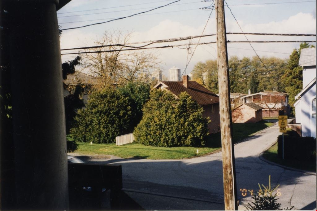
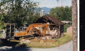
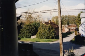
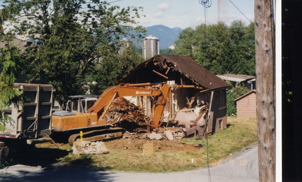
Looking north from 5496 Dominion Street
https://search.heritageburnaby.ca/link/archivedescription91855
- Repository
- City of Burnaby Archives
- Date
- 2002
- Collection/Fonds
- Small family fonds
- Description Level
- Item
- Physical Description
- 1 photograph : col. ; 10 cm x 15 cm
- Scope and Content
- Photograph of the house at 5493 Dominion Street being demolished. The house was previously owned by the McLean family. The photograph was taken from 5496 Dominion Street, looking north.
- Repository
- City of Burnaby Archives
- Date
- 2002
- Collection/Fonds
- Small family fonds
- Physical Description
- 1 photograph : col. ; 10 cm x 15 cm
- Description Level
- Item
- Record No.
- 620-036
- Access Restriction
- No restrictions
- Reproduction Restriction
- No reproduction permitted
- Accession Number
- 2017-01
- Scope and Content
- Photograph of the house at 5493 Dominion Street being demolished. The house was previously owned by the McLean family. The photograph was taken from 5496 Dominion Street, looking north.
- Media Type
- Photograph
- Notes
- Transcribed title
- Note in blue ink on verso of photograph reads: "P.35"
- Note in blue ink on verso of photograph reads: "2002"
- Note in blue ink on verso of photograph reads: "Farewell [illegible] old house on Dominion Street"
- 5493 Dominion Street was previously numbered 3107 Dominion Street and it was later subdivided into two lots: 5491 and 5495 Dominion Street.
- Street Address
- 3107 Dominion Street
- 5493 Dominion Street
- Historic Neighbourhood
- Burnaby Lake (Historic Neighbourhood)
- Planning Study Area
- Ardingley-Sprott Area
Images

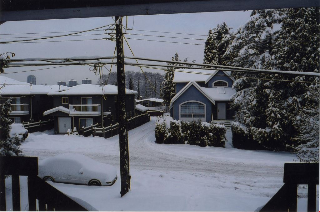
Looking north from 5496 Dominion Street
https://search.heritageburnaby.ca/link/archivedescription91856
- Repository
- City of Burnaby Archives
- Date
- December 22, 2008
- Collection/Fonds
- Small family fonds
- Description Level
- Item
- Physical Description
- 1 photograph : col. ; 10 cm x 15 cm
- Scope and Content
- Photograph of two duplexes located at 5491 and 5495 Dominion Street (left) and house at 5505 Dominion Street (right) after a snowfall. The duplexes replaced a single-family home located at 5493 (previously 3107) Dominion Street following the lot's subdivision. The photograph was taken from the po…
- Repository
- City of Burnaby Archives
- Date
- December 22, 2008
- Collection/Fonds
- Small family fonds
- Physical Description
- 1 photograph : col. ; 10 cm x 15 cm
- Description Level
- Item
- Record No.
- 620-037
- Access Restriction
- No restrictions
- Reproduction Restriction
- No reproduction permitted
- Accession Number
- 2017-01
- Scope and Content
- Photograph of two duplexes located at 5491 and 5495 Dominion Street (left) and house at 5505 Dominion Street (right) after a snowfall. The duplexes replaced a single-family home located at 5493 (previously 3107) Dominion Street following the lot's subdivision. The photograph was taken from the porch at 5496 Dominion street, looking north.
- Media Type
- Photograph
- Notes
- Title based on contents of photograph
- Note in blue ink on verso of photograph reads: "P.36"
- Note in blue ink on verso of photograph reads: "Dec. 22, 2008 / 2 New Duplex's replace 5493 Dominion Street"
- 5493 Dominion Street was previously numbered 3107 Dominion Street and it was later subdivided into two lots: 5491 and 5495 Dominion Street.
- Photograph 620-034 depicts the same house at 5505 Dominion Street and the previous house located at 5495 Dominion Street.
- Historic Neighbourhood
- Burnaby Lake (Historic Neighbourhood)
- Planning Study Area
- Ardingley-Sprott Area
Images

5495 Dominion Street and 5505 Dominion Street
https://search.heritageburnaby.ca/link/archivedescription91857
- Repository
- City of Burnaby Archives
- Date
- April 1, 2015
- Collection/Fonds
- Small family fonds
- Description Level
- Item
- Physical Description
- 1 photograph : col. ; 10 cm x 15 cm
- Scope and Content
- Photograph of a tan duplex located at 5495 Dominion Street (left) and clay-coloured house at 5505 Dominion Street (right). The photograph was taken from 5496 Dominion street, looking north.
- Repository
- City of Burnaby Archives
- Date
- April 1, 2015
- Collection/Fonds
- Small family fonds
- Physical Description
- 1 photograph : col. ; 10 cm x 15 cm
- Description Level
- Item
- Record No.
- 620-038
- Access Restriction
- No restrictions
- Reproduction Restriction
- No reproduction permitted
- Accession Number
- 2017-01
- Scope and Content
- Photograph of a tan duplex located at 5495 Dominion Street (left) and clay-coloured house at 5505 Dominion Street (right). The photograph was taken from 5496 Dominion street, looking north.
- Subjects
- Buildings - Residential - Houses
- Media Type
- Photograph
- Notes
- Transcribed title
- Title transcribed from donor's notes
- Note in blue ink on verso of photograph reads: "P.37"
- Note in blue ink on verso of photograph reads: "April 1 , 2015 / 5495 Dominion st. 5505 Dominion St."
- 5493 Dominion Street was previously numbered 3107 Dominion Street and it was later subdivided into two lots: 5491 and 5495 Dominion Street.
- Photograph 620-037 depicts the same houses prior to being repainted.
- Historic Neighbourhood
- Burnaby Lake (Historic Neighbourhood)
- Planning Study Area
- Ardingley-Sprott Area
Images


Looking west along the back lane
https://search.heritageburnaby.ca/link/archivedescription91861
- Repository
- City of Burnaby Archives
- Date
- April 2015
- Collection/Fonds
- Small family fonds
- Description Level
- Item
- Physical Description
- 1 photograph : col. ; 10 cm x 15 cm
- Scope and Content
- Photograph of the back lane between Dominion Street and Norfolk Street, looking west. Visible along the Norfolk Street side of the lane are houses with garages and longer driveways. Along the Dominion Street side the lane is abutted by trees and open carports. The houses along Norfolk Street wer…
- Repository
- City of Burnaby Archives
- Date
- April 2015
- Collection/Fonds
- Small family fonds
- Physical Description
- 1 photograph : col. ; 10 cm x 15 cm
- Description Level
- Item
- Record No.
- 620-042
- Access Restriction
- No restrictions
- Reproduction Restriction
- No reproduction permitted
- Accession Number
- 2017-01
- Scope and Content
- Photograph of the back lane between Dominion Street and Norfolk Street, looking west. Visible along the Norfolk Street side of the lane are houses with garages and longer driveways. Along the Dominion Street side the lane is abutted by trees and open carports. The houses along Norfolk Street were constructed in the 1980s and 1990s following the rezoning of the properties.
- Media Type
- Photograph
- Notes
- Transcribed title
- Title transcribed from donor's notes
- Note in blue ink on verso of photograph reads: "P.5"
- Note in blue ink on verso of photograph reads: "April 1, 2015"
- Historic Neighbourhood
- Burnaby Lake (Historic Neighbourhood)
- Planning Study Area
- Ardingley-Sprott Area
Images


Looking west from back yard of 5496 Dominion Street
https://search.heritageburnaby.ca/link/archivedescription91866
- Repository
- City of Burnaby Archives
- Date
- April 1, 2015
- Collection/Fonds
- Small family fonds
- Description Level
- Item
- Physical Description
- 1 photograph : col. copy print ; 10 cm x 15 cm
- Scope and Content
- Photograph of the backyard at 5496 Dominion Street, looking west, with the houses on Norfolk Street (left) and Dominion Street (right) visible in the background.
- Repository
- City of Burnaby Archives
- Date
- April 1, 2015
- Collection/Fonds
- Small family fonds
- Physical Description
- 1 photograph : col. copy print ; 10 cm x 15 cm
- Description Level
- Item
- Record No.
- 620-047
- Access Restriction
- No restrictions
- Reproduction Restriction
- No reproduction permitted
- Accession Number
- 2017-01
- Scope and Content
- Photograph of the backyard at 5496 Dominion Street, looking west, with the houses on Norfolk Street (left) and Dominion Street (right) visible in the background.
- Media Type
- Photograph
- Notes
- Transcribed title
- Title transcribed from donor's notes
- Note in blue ink on verso of photograph reads: "P.10"
- Note in black ink on verso of photograph reads: "April 1, 2015"
- Geographic Access
- Dominion Street
- Norfolk Street
- Street Address
- 5496 Dominion Street
- Historic Neighbourhood
- Burnaby Lake (Historic Neighbourhood)
- Planning Study Area
- Ardingley-Sprott Area
Images


Looking west along Dominion Street from 5496 Dominion Street
https://search.heritageburnaby.ca/link/archivedescription91873
- Repository
- City of Burnaby Archives
- Date
- July 2016
- Collection/Fonds
- Small family fonds
- Description Level
- Item
- Physical Description
- 1 photograph : col. copy print ; 10 cm x 15 cm
- Scope and Content
- Photograph of the houses along Dominion Street, looking west from 5496 Dominion Street. The two houses in the foreground, 5480 and 5488 Dominion Street, were constructed in 1994 on the lot previously numbered 5486 Dominion Street.
- Repository
- City of Burnaby Archives
- Date
- July 2016
- Collection/Fonds
- Small family fonds
- Physical Description
- 1 photograph : col. copy print ; 10 cm x 15 cm
- Description Level
- Item
- Record No.
- 620-054
- Access Restriction
- No restrictions
- Reproduction Restriction
- No reproduction permitted
- Accession Number
- 2017-01
- Scope and Content
- Photograph of the houses along Dominion Street, looking west from 5496 Dominion Street. The two houses in the foreground, 5480 and 5488 Dominion Street, were constructed in 1994 on the lot previously numbered 5486 Dominion Street.
- Subjects
- Buildings - Residential - Houses
- Media Type
- Photograph
- Notes
- Transcribed title
- Title transcribed from donor's notes
- Note in blue ink on verso of photograph reads: "P.16"
- Note in blue ink on verso of photograph reads: "Houses at 5480 and 5488 Dominion St. / built in 1994"
- Photo production stamp on verso of photograph reads: "07/03/2016"
- Street Address
- 5488 Dominion Street
- 5480 Dominion Street
- Historic Neighbourhood
- Burnaby Lake (Historic Neighbourhood)
- Planning Study Area
- Ardingley-Sprott Area
Images


Looking west along Dominion Street from across the street from 5496 Dominion Street
https://search.heritageburnaby.ca/link/archivedescription91874
- Repository
- City of Burnaby Archives
- Date
- July 2016
- Collection/Fonds
- Small family fonds
- Description Level
- Item
- Physical Description
- 1 photograph : col. copy print ; 10 cm x 15 cm
- Scope and Content
- Photograph of the houses along the south side of Dominion Street with cars parked along the curb. In 2009 sidewalks were installed and the street was repaved under a neighbourhood local improvement request to the City. The photograph was taken from the north side of the street, opposite 5496 Dom…
- Repository
- City of Burnaby Archives
- Date
- July 2016
- Collection/Fonds
- Small family fonds
- Physical Description
- 1 photograph : col. copy print ; 10 cm x 15 cm
- Description Level
- Item
- Record No.
- 620-055
- Access Restriction
- No restrictions
- Reproduction Restriction
- No reproduction permitted
- Accession Number
- 2017-01
- Scope and Content
- Photograph of the houses along the south side of Dominion Street with cars parked along the curb. In 2009 sidewalks were installed and the street was repaved under a neighbourhood local improvement request to the City. The photograph was taken from the north side of the street, opposite 5496 Dominion Street, looking west.
- Media Type
- Photograph
- Notes
- Transcribed title
- Title transcribed from donor's notes
- Note in blue ink on verso of photograph reads: "P.17"
- Note in blue ink on verso of photograph reads: "Dominion St. infilled with houses on 33' lots / Photo July 2016"
- Geographic Access
- Dominion Street
- Historic Neighbourhood
- Burnaby Lake (Historic Neighbourhood)
- Planning Study Area
- Ardingley-Sprott Area
Images
