
Kingsway at 16th Avenue
https://search.heritageburnaby.ca/link/museumdescription3093
- Repository
- Burnaby Village Museum
- Date
- 1913
- Collection/Fonds
- Burnaby Village Museum Photograph collection
- Description Level
- Item
- Physical Description
- 1 photograph : b&w glass negative ; 15.8 x 21.1 cm
- Scope and Content
- Photograph of Kingsway looking northwest from 16th Avenue. On the lefthand side of the road, driving to New Westminster is a car with three men in suits and bowler hats. The car license plate reads, "BC/ 2720/ 1913." Following the car is a horse pulling a wagon. Further north, a small street car…
- Repository
- Burnaby Village Museum
- Collection/Fonds
- Burnaby Village Museum Photograph collection
- Description Level
- Item
- Physical Description
- 1 photograph : b&w glass negative ; 15.8 x 21.1 cm
- Scope and Content
- Photograph of Kingsway looking northwest from 16th Avenue. On the lefthand side of the road, driving to New Westminster is a car with three men in suits and bowler hats. The car license plate reads, "BC/ 2720/ 1913." Following the car is a horse pulling a wagon. Further north, a small street car can be seen, probably moving southward. According to the 1988 catalogue record, the two houses on the left are separated by Hubert Avenue. The larger house on the left is the home of of Mr. and Mrs. John McNiven, now demolished. The smaller house in the distance, being constructed, is the Britton family home. On the right in the distance, the roof and twin chimneys of the 1890s Stride home can be seen, which later became the Sylvan Court Apartment Building.
- Subjects
- Geographic Features - Roads
- Geographic Access
- Kingsway
- 16th Avenue
- Accession Code
- HV972.11.7
- Access Restriction
- No restrictions
- Reproduction Restriction
- No known restrictions
- Date
- 1913
- Media Type
- Photograph
- Historic Neighbourhood
- Edmonds (Historic Neighbourhood)
- Planning Study Area
- Edmonds Area
- Stride Avenue Area
- Scan Resolution
- 300
- Scan Date
- 14/8/2006
- Scale
- 100
- Notes
- Title based on contents of photograph
- 1 b&w contact print accompanying negative
Images

Sutherland house
https://search.heritageburnaby.ca/link/archivedescription35139
- Repository
- City of Burnaby Archives
- Date
- 1985
- Collection/Fonds
- Burnaby Historical Society fonds
- Description Level
- Item
- Physical Description
- 1 photograph : col. ; 11.1 x 14.8 cm
- Scope and Content
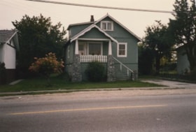
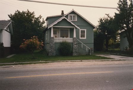
- Photograph of the Sutherland house, 8246 16th Avenue, built in 1912.
- Repository
- City of Burnaby Archives
- Date
- 1985
- Collection/Fonds
- Burnaby Historical Society fonds
- Subseries
- Bill Sutherland subseries
- Physical Description
- 1 photograph : col. ; 11.1 x 14.8 cm
- Description Level
- Item
- Record No.
- 202-001
- Access Restriction
- No restrictions
- Reproduction Restriction
- Reproduce for fair dealing purposes only
- Accession Number
- BHS1987-11
- Scope and Content
- Photograph of the Sutherland house, 8246 16th Avenue, built in 1912.
- Subjects
- Buildings - Residential - Houses
- Media Type
- Photograph
- Notes
- Title based on contents of photograph
- Annotation on the back of the photograph reads, "8246 16th Avenue. Built in 1912 by Mr. Sutherland."
- Geographic Access
- 16th Avenue
- Street Address
- 8246 16th Avenue
- Historic Neighbourhood
- East Burnaby (Historic Neighbourhood)
- Planning Study Area
- Second Street Area
Images
Edmonds St + 18th Ave (SW of 16th Street)
https://search.heritageburnaby.ca/link/archivedescription93727
- Repository
- City of Burnaby Archives
- Date
- March 1989
- Collection/Fonds
- Grover, Elliott & Co. Ltd. fonds
- Description Level
- File
- Physical Description
- 14 photographs : col. negatives ; 35 mm
- Scope and Content
- Photographs of the intersections at Edmonds Street and 18th Avenue and Edmonds Street and 16th Avenue and an unidentified residential lane.
- Repository
- City of Burnaby Archives
- Date
- March 1989
- Collection/Fonds
- Grover, Elliott & Co. Ltd. fonds
- Physical Description
- 14 photographs : col. negatives ; 35 mm
- Description Level
- File
- Record No.
- 622-015
- Access Restriction
- No restrictions
- Reproduction Restriction
- No restrictions
- Accession Number
- 2017-39
- Scope and Content
- Photographs of the intersections at Edmonds Street and 18th Avenue and Edmonds Street and 16th Avenue and an unidentified residential lane.
- Media Type
- Photograph
- Notes
- Transcribed title
- Title transcribed from original print envelope
- Photographs 622-015-001 : 622-015-002 depict Edmonds Street and 16th Avenue, facing south
- Photographs 622-015-003 : 622-015-004 depict the view southwest along Edmonds Street
- Photographs 622-015-006 : 622-015-008 depict the view southeast along 16th Street
- Photographs 622-015-009 : 622-015-011 depict the view southwest along 18th Avenue
- Locations were identified using notes on verso of accompanying prints
- Geographic Access
- 18th Avenue
- Edmonds Street
- 16th Avenue
- Historic Neighbourhood
- Edmonds (Historic Neighbourhood)
- Planning Study Area
- Stride Avenue Area