Narrow Results By
Subject
- Accidents 1
- Advertising Medium - Signs and Signboards 8
- Agriculture - Farms 2
- Animals - Horses 2
- Buildings - Agricultural - Barns 1
- Buildings - Civic - Fire Halls 1
- Buildings - Commercial - Grocery Stores 2
- Buildings - Commercial - Restaurants 1
- Buildings - Heritage 1
- Buildings - Recreational 1
- Buildings - Religious - Churches 2
- Buildings - Residential - Apartments 2
Person / Organization
- A & Aero Trading Salvage 1
- Arlington's Market 1
- British Columbia Hydro and Power Authority 3
- Galaxie Collision Ltd. 1
- Kask Brothers 3
- Kask Camp 3
- Kensington Arena 2
- Kensington Junior Secondary School 1
- Kensington Park Pitch and Putt 1
- Maverick Coach Lines Ltd. 1
- Our Lady of Mercy Church 1
- Paddy's Pizza Place 1
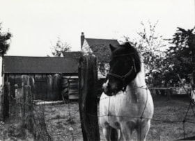
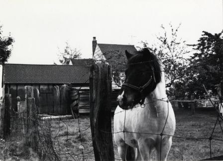
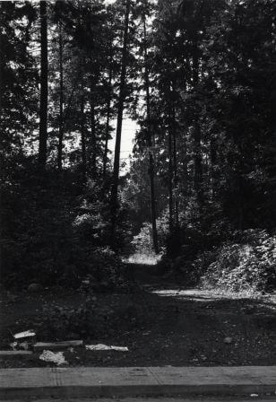
Horse at 6861 Kitchener Street
https://search.heritageburnaby.ca/link/archivedescription78997
- Repository
- City of Burnaby Archives
- Date
- October 4, 1976
- Collection/Fonds
- Burnaby Public Library Contemporary Visual Archive Project
- Description Level
- Item
- Physical Description
- 1 photograph : b&w ; 11 x 16 cm mounted on cardboard
- Scope and Content
- Photograph shows a horse, named Naylor, at 6861 Kitchener Street near Cliff Avenue. The horse was owned by an SFU student and boarded at the lot on Kitchener Street.
- Repository
- City of Burnaby Archives
- Date
- October 4, 1976
- Collection/Fonds
- Burnaby Public Library Contemporary Visual Archive Project
- Physical Description
- 1 photograph : b&w ; 11 x 16 cm mounted on cardboard
- Description Level
- Item
- Record No.
- 556-081
- Access Restriction
- No restrictions
- Reproduction Restriction
- Reproduce for fair dealing purposes only
- Accession Number
- 2013-13
- Scope and Content
- Photograph shows a horse, named Naylor, at 6861 Kitchener Street near Cliff Avenue. The horse was owned by an SFU student and boarded at the lot on Kitchener Street.
- Subjects
- Animals - Horses
- Media Type
- Photograph
- Photographer
- Born, A. J.
- Notes
- Scope note taken directly from BPL photograph description.
- 1 b&w copy negative : 10 x 12.5 cm accompanying
- Geographic Access
- Kitchener Street
- Street Address
- 6861 Kitchener Street
- Historic Neighbourhood
- Lochdale (Historic Neighbourhood)
- Planning Study Area
- Lochdale Area
Images

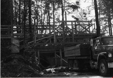
Home Construction at 6409 Buckingham Drive
https://search.heritageburnaby.ca/link/archivedescription79000
- Repository
- City of Burnaby Archives
- Date
- September 24, 1976
- Collection/Fonds
- Burnaby Public Library Contemporary Visual Archive Project
- Description Level
- Item
- Physical Description
- 1 photograph : b&w ; 11 x 16 cm mounted on cardboard
- Scope and Content
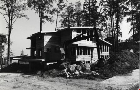
- Photograph shows house construction in progress at 6409 Buckingham Drive. The home was designed and built by the owner, an architect at Bemben & Kuzych Architects in Burnaby. At the time of the photograph a Riverdale Lumber Ltd. truck was delivering lumber to the site.
- Repository
- City of Burnaby Archives
- Date
- September 24, 1976
- Collection/Fonds
- Burnaby Public Library Contemporary Visual Archive Project
- Physical Description
- 1 photograph : b&w ; 11 x 16 cm mounted on cardboard
- Description Level
- Item
- Record No.
- 556-083
- Access Restriction
- No restrictions
- Reproduction Restriction
- Reproduce for fair dealing purposes only
- Accession Number
- 2013-13
- Scope and Content
- Photograph shows house construction in progress at 6409 Buckingham Drive. The home was designed and built by the owner, an architect at Bemben & Kuzych Architects in Burnaby. At the time of the photograph a Riverdale Lumber Ltd. truck was delivering lumber to the site.
- Subjects
- Construction
- Media Type
- Photograph
- Photographer
- Born, A. J.
- Notes
- Scope note taken directly from BPL photograph description.
- 1 b&w copy negative : 10 x 12.5 cm accompanying
- Geographic Access
- Buckingham Drive
- Street Address
- 6409 Buckingham Drive
- Historic Neighbourhood
- Burnaby Lake (Historic Neighbourhood)
- Planning Study Area
- Morley-Buckingham Area
Images

House at 6390 Charing Court
https://search.heritageburnaby.ca/link/archivedescription79004
- Repository
- City of Burnaby Archives
- Date
- September 16, 1976
- Collection/Fonds
- Burnaby Public Library Contemporary Visual Archive Project
- Description Level
- Item
- Physical Description
- 1 photograph : b&w ; 11 x 16 cm mounted on cardboard
- Scope and Content
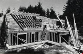
- Photograph shows house construction in progress at 6390 Charing Court.
- Repository
- City of Burnaby Archives
- Date
- September 16, 1976
- Collection/Fonds
- Burnaby Public Library Contemporary Visual Archive Project
- Physical Description
- 1 photograph : b&w ; 11 x 16 cm mounted on cardboard
- Description Level
- Item
- Record No.
- 556-085
- Access Restriction
- No restrictions
- Reproduction Restriction
- Reproduce for fair dealing purposes only
- Accession Number
- 2013-13
- Scope and Content
- Photograph shows house construction in progress at 6390 Charing Court.
- Subjects
- Construction
- Media Type
- Photograph
- Photographer
- Born, A. J.
- Notes
- Scope note taken directly from BPL photograph description.
- 1 b&w copy negative : 10 x 12.5 cm accompanying
- Geographic Access
- Charing Court
- Street Address
- 6390 Charing Court
- Historic Neighbourhood
- Burnaby Lake (Historic Neighbourhood)
- Planning Study Area
- Morley-Buckingham Area
Images
House construction on Paulus Crescent
https://search.heritageburnaby.ca/link/archivedescription79006
- Repository
- City of Burnaby Archives
- Date
- September 7, 1976
- Collection/Fonds
- Burnaby Public Library Contemporary Visual Archive Project
- Description Level
- Item
- Physical Description
- 1 photograph : b&w ; 11 x 16 cm mounted on cardboard
- Scope and Content
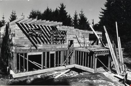
- Photograph shows house under construction on Paulus Crescent.
- Repository
- City of Burnaby Archives
- Date
- September 7, 1976
- Collection/Fonds
- Burnaby Public Library Contemporary Visual Archive Project
- Physical Description
- 1 photograph : b&w ; 11 x 16 cm mounted on cardboard
- Description Level
- Item
- Record No.
- 556-086
- Access Restriction
- No restrictions
- Reproduction Restriction
- Reproduce for fair dealing purposes only
- Accession Number
- 2013-13
- Scope and Content
- Photograph shows house under construction on Paulus Crescent.
- Subjects
- Construction
- Media Type
- Photograph
- Photographer
- Born, A. J.
- Notes
- Scope note taken directly from BPL photograph description.
- 1 b&w copy negative : 10 x 12.5 cm accompanying
- Geographic Access
- Paulus Crescent
- Historic Neighbourhood
- Lochdale (Historic Neighbourhood)
- Planning Study Area
- Sperling-Broadway Area
Images
Vacant lot at 6300 Block Buckingham Avenue
https://search.heritageburnaby.ca/link/archivedescription79009
- Repository
- City of Burnaby Archives
- Date
- September 24, 1976
- Collection/Fonds
- Burnaby Public Library Contemporary Visual Archive Project
- Description Level
- Item
- Physical Description
- 1 photograph : b&w ; 11 x 16 cm mounted on cardboard
- Scope and Content
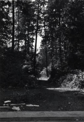
- Photograph shows a vacant lot in the 6300 Block Buckingham Drive. This was the last undeveloped lot in a block of houses under construction at the time of the photograph.
- Repository
- City of Burnaby Archives
- Date
- September 24, 1976
- Collection/Fonds
- Burnaby Public Library Contemporary Visual Archive Project
- Physical Description
- 1 photograph : b&w ; 11 x 16 cm mounted on cardboard
- Description Level
- Item
- Record No.
- 556-088
- Access Restriction
- No restrictions
- Reproduction Restriction
- Reproduce for fair dealing purposes only
- Accession Number
- 2013-13
- Scope and Content
- Photograph shows a vacant lot in the 6300 Block Buckingham Drive. This was the last undeveloped lot in a block of houses under construction at the time of the photograph.
- Media Type
- Photograph
- Photographer
- Born, A. J.
- Notes
- Scope note taken directly from BPL photograph description.
- 1 b&w copy negative : 10 x 12.5 cm accompanying
- Geographic Access
- Buckingham Drive
- Historic Neighbourhood
- Burnaby Lake (Historic Neighbourhood)
- Planning Study Area
- Morley-Buckingham Area
Images

Apartments at 5220 Capitol Drive
https://search.heritageburnaby.ca/link/archivedescription79032
- Repository
- City of Burnaby Archives
- Date
- November 18, 1976
- Collection/Fonds
- Burnaby Public Library Contemporary Visual Archive Project
- Description Level
- Item
- Physical Description
- 1 photograph : b&w ; 11 x 16 cm mounted on cardboard
- Scope and Content
- Photograph shows cherubs in front of the Villa Koma apartments at 5220 Capitol Drive.
- Repository
- City of Burnaby Archives
- Date
- November 18, 1976
- Collection/Fonds
- Burnaby Public Library Contemporary Visual Archive Project
- Physical Description
- 1 photograph : b&w ; 11 x 16 cm mounted on cardboard
- Description Level
- Item
- Record No.
- 556-103
- Access Restriction
- No restrictions
- Reproduction Restriction
- Reproduce for fair dealing purposes only
- Accession Number
- 2013-13
- Scope and Content
- Photograph shows cherubs in front of the Villa Koma apartments at 5220 Capitol Drive.
- Subjects
- Buildings - Residential - Apartments
- Media Type
- Photograph
- Photographer
- Born, A. J.
- Notes
- Scope note taken directly from BPL photograph description.
- 1 b&w copy negative : 10 x 12.5 cm accompanying
- Geographic Access
- Capitol Drive
- Street Address
- 5220 Capitol Drive
- Historic Neighbourhood
- Capitol Hill (Historic Neighbourhood)
- Planning Study Area
- Capitol Hill Area
Images


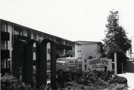
Garden Apartments
https://search.heritageburnaby.ca/link/archivedescription79033
- Repository
- City of Burnaby Archives
- Date
- September 20, 1976
- Collection/Fonds
- Burnaby Public Library Contemporary Visual Archive Project
- Description Level
- Item
- Physical Description
- 1 photograph : b&w ; 11 x 16 cm mounted on cardboard
- Scope and Content
- Photograph shows the Garden Apartments at 5700-5900 Hastings, built in 1952.
- Repository
- City of Burnaby Archives
- Date
- September 20, 1976
- Collection/Fonds
- Burnaby Public Library Contemporary Visual Archive Project
- Physical Description
- 1 photograph : b&w ; 11 x 16 cm mounted on cardboard
- Description Level
- Item
- Record No.
- 556-104
- Access Restriction
- No restrictions
- Reproduction Restriction
- Reproduce for fair dealing purposes only
- Accession Number
- 2013-13
- Scope and Content
- Photograph shows the Garden Apartments at 5700-5900 Hastings, built in 1952.
- Subjects
- Buildings - Residential - Apartments
- Media Type
- Photograph
- Photographer
- Born, A. J.
- Notes
- Scope note taken directly from BPL photograph description.
- 1 b&w copy negative : 10 x 12.5 cm accompanying
- Geographic Access
- Hastings Street
- Planning Study Area
- Parkcrest-Aubrey Area
Images

Parish Church of Our Lady of Mercy
https://search.heritageburnaby.ca/link/archivedescription79043
- Repository
- City of Burnaby Archives
- Date
- September 16, 1976
- Collection/Fonds
- Burnaby Public Library Contemporary Visual Archive Project
- Description Level
- Item
- Physical Description
- 1 photograph : b&w ; 11 x 16 cm mounted on cardboard
- Scope and Content
- Photograph shows the Parish Church of Our Lady of Mercy located at 7892 Kingsway (later 7455 10th Avenue). Construction of this church was held up by World War II but it was completed in 1944.
- Repository
- City of Burnaby Archives
- Date
- September 16, 1976
- Collection/Fonds
- Burnaby Public Library Contemporary Visual Archive Project
- Physical Description
- 1 photograph : b&w ; 11 x 16 cm mounted on cardboard
- Description Level
- Item
- Record No.
- 556-110
- Access Restriction
- No restrictions
- Reproduction Restriction
- Reproduce for fair dealing purposes only
- Accession Number
- 2013-13
- Scope and Content
- Photograph shows the Parish Church of Our Lady of Mercy located at 7892 Kingsway (later 7455 10th Avenue). Construction of this church was held up by World War II but it was completed in 1944.
- Subjects
- Buildings - Religious - Churches
- Names
- Our Lady of Mercy Church
- Media Type
- Photograph
- Photographer
- Born, A. J.
- Notes
- Scope note taken directly from BPL photograph description.
- 1 b&w copy negative : 10 x 12.5 cm accompanying
- Geographic Access
- Kingsway
- 10th Avenue
- Street Address
- 7892 Kingsway
- 7455 10th Avenue
- Historic Neighbourhood
- Edmonds (Historic Neighbourhood)
- Planning Study Area
- Edmonds Area
Images


Parkcrest Bible Chapel
https://search.heritageburnaby.ca/link/archivedescription79045
- Repository
- City of Burnaby Archives
- Date
- September 7, 1976
- Collection/Fonds
- Burnaby Public Library Contemporary Visual Archive Project
- Description Level
- Item
- Physical Description
- 1 photograph : b&w ; 11 x 16 cm mounted on cardboard
- Scope and Content
- Photograph shows the Parkcrest Bible Chapel at 6641 Halifax Street. It was built in 1962.
- Repository
- City of Burnaby Archives
- Date
- September 7, 1976
- Collection/Fonds
- Burnaby Public Library Contemporary Visual Archive Project
- Physical Description
- 1 photograph : b&w ; 11 x 16 cm mounted on cardboard
- Description Level
- Item
- Record No.
- 556-112
- Access Restriction
- No restrictions
- Reproduction Restriction
- Reproduce for fair dealing purposes only
- Accession Number
- 2013-13
- Scope and Content
- Photograph shows the Parkcrest Bible Chapel at 6641 Halifax Street. It was built in 1962.
- Subjects
- Buildings - Religious - Churches
- Names
- Parkcrest Bible Chapel
- Media Type
- Photograph
- Photographer
- Born, A. J.
- Notes
- Scope note taken directly from BPL photograph description.
- 1 b&w copy negative : 10 x 12.5 cm accompanying
- Geographic Access
- Halifax Street
- Street Address
- 6641 Halifaxt Street
- Historic Neighbourhood
- Lochdale (Historic Neighbourhood)
- Planning Study Area
- Lochdale Area
Images

Arlington's Market
https://search.heritageburnaby.ca/link/archivedescription79094
- Repository
- City of Burnaby Archives
- Date
- September 7, 1976
- Collection/Fonds
- Burnaby Public Library Contemporary Visual Archive Project
- Description Level
- Item
- Physical Description
- 1 photograph : b&w ; 11 x 16 cm mounted on cardboard
- Scope and Content
- Photograph shows an unidentified woman coming out of Arlington's Market at 5962 Sperling Avenue near Walker Avenue.
- Repository
- City of Burnaby Archives
- Date
- September 7, 1976
- Collection/Fonds
- Burnaby Public Library Contemporary Visual Archive Project
- Physical Description
- 1 photograph : b&w ; 11 x 16 cm mounted on cardboard
- Description Level
- Item
- Record No.
- 556-148
- Access Restriction
- No restrictions
- Reproduction Restriction
- Reproduce for fair dealing purposes only
- Accession Number
- 2013-13
- Scope and Content
- Photograph shows an unidentified woman coming out of Arlington's Market at 5962 Sperling Avenue near Walker Avenue.
- Names
- Arlington's Market
- Media Type
- Photograph
- Photographer
- Born, A. J.
- Notes
- Scope note taken directly from BPL photograph description.
- 1 b&w copy negative : 10 x 12.5 cm accompanying
- Geographic Access
- Sperling Avenue
- Street Address
- 5962 Sperling Avenue
- Historic Neighbourhood
- Edmonds (Historic Neighbourhood)
- Planning Study Area
- Kingsway-Beresford Area
Images


Yangtze Market
https://search.heritageburnaby.ca/link/archivedescription79112
- Repository
- City of Burnaby Archives
- Date
- September 16, 1976
- Collection/Fonds
- Burnaby Public Library Contemporary Visual Archive Project
- Description Level
- Item
- Physical Description
- 1 photograph : b&w ; 11 x 16 cm mounted on cardboard
- Scope and Content
- Photograph shows the Yangtze Market at 7447 Edmonds Street and the corner of Edmonds and Humphries Avenue.
- Repository
- City of Burnaby Archives
- Date
- September 16, 1976
- Collection/Fonds
- Burnaby Public Library Contemporary Visual Archive Project
- Physical Description
- 1 photograph : b&w ; 11 x 16 cm mounted on cardboard
- Description Level
- Item
- Record No.
- 556-160
- Access Restriction
- No restrictions
- Reproduction Restriction
- Reproduce for fair dealing purposes only
- Accession Number
- 2013-13
- Scope and Content
- Photograph shows the Yangtze Market at 7447 Edmonds Street and the corner of Edmonds and Humphries Avenue.
- Names
- Yangtze Market
- Media Type
- Photograph
- Photographer
- Born, A. J.
- Notes
- Scope note taken directly from BPL photograph description.
- 1 b&w copy negative : 10 x 12.5 cm accompanying
- Geographic Access
- Edmonds Street
- Street Address
- 7447 Edmonds Street
- Historic Neighbourhood
- Edmonds (Historic Neighbourhood)
- Planning Study Area
- Richmond Park Area
Images
A & Aero Trading Salvage
https://search.heritageburnaby.ca/link/archivedescription79167
- Repository
- City of Burnaby Archives
- Date
- October 12, 1976
- Collection/Fonds
- Burnaby Public Library Contemporary Visual Archive Project
- Description Level
- Item
- Physical Description
- 1 photograph : b&w ; 11 x 16 cm mounted on cardboard
- Scope and Content
- Photograph shows hitchikers being picked up outside A & Aero Trading and Salvage at 6147 Hastings Street.
- Repository
- City of Burnaby Archives
- Date
- October 12, 1976
- Collection/Fonds
- Burnaby Public Library Contemporary Visual Archive Project
- Physical Description
- 1 photograph : b&w ; 11 x 16 cm mounted on cardboard
- Description Level
- Item
- Record No.
- 556-185
- Access Restriction
- No restrictions
- Reproduction Restriction
- Reproduce for fair dealing purposes only
- Accession Number
- 2013-13
- Scope and Content
- Photograph shows hitchikers being picked up outside A & Aero Trading and Salvage at 6147 Hastings Street.
- Names
- A & Aero Trading Salvage
- Media Type
- Photograph
- Photographer
- Born, A. J.
- Notes
- Scope note taken directly from BPL photograph description.
- 1 b&w copy negative : 10 x 12.5 cm accompanying
- Geographic Access
- Hastings Street
- Street Address
- 6147 Hastings Street
- Historic Neighbourhood
- Lochdale (Historic Neighbourhood)
- Planning Study Area
- Westridge Area
Images
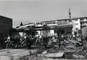
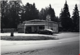
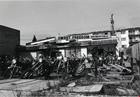
Sweet Freedom Recreation Ltd.
https://search.heritageburnaby.ca/link/archivedescription79243
- Repository
- City of Burnaby Archives
- Date
- September 24, 1976
- Collection/Fonds
- Burnaby Public Library Contemporary Visual Archive Project
- Description Level
- Item
- Physical Description
- 1 photograph : b&w ; 11 x 16 cm mounted on cardboard
- Scope and Content
- Photograph shows Sweet Freedom Recreation Ltd., a motorcycle dealer at 7031 and 7025 Kingsway.
- Repository
- City of Burnaby Archives
- Date
- September 24, 1976
- Collection/Fonds
- Burnaby Public Library Contemporary Visual Archive Project
- Physical Description
- 1 photograph : b&w ; 11 x 16 cm mounted on cardboard
- Description Level
- Item
- Record No.
- 556-220
- Access Restriction
- No restrictions
- Reproduction Restriction
- Reproduce for fair dealing purposes only
- Accession Number
- 2013-13
- Scope and Content
- Photograph shows Sweet Freedom Recreation Ltd., a motorcycle dealer at 7031 and 7025 Kingsway.
- Subjects
- Transportation - Motorcycles
- Media Type
- Photograph
- Photographer
- Born, A. J.
- Notes
- Scope note taken directly from BPL photograph description.
- 1 b&w copy negative : 10 x 12.5 cm accompanying
- Geographic Access
- Kingsway
- Street Address
- 7031 Kingsway
- 7025 Kingsway
- Historic Neighbourhood
- Edmonds (Historic Neighbourhood)
- Planning Study Area
- Richmond Park Area
Images

Galaxie Collision Ltd.
https://search.heritageburnaby.ca/link/archivedescription79255
- Repository
- City of Burnaby Archives
- Date
- September 24, 1976
- Collection/Fonds
- Burnaby Public Library Contemporary Visual Archive Project
- Description Level
- Item
- Physical Description
- 1 photograph : b&w ; 11 x 16 cm mounted on cardboard
- Scope and Content
- Photograph shows a sign attached to an old automobile advertising Galaxie Collision Ltd. The car and sign are parked in a lot on the corner of Kingsway and Griffiths Avenue directing people to the business one block south of Kingsway at 7498A Griffiths Avenue.
- Repository
- City of Burnaby Archives
- Date
- September 24, 1976
- Collection/Fonds
- Burnaby Public Library Contemporary Visual Archive Project
- Physical Description
- 1 photograph : b&w ; 11 x 16 cm mounted on cardboard
- Description Level
- Item
- Record No.
- 556-224
- Access Restriction
- No restrictions
- Reproduction Restriction
- Reproduce for fair dealing purposes only
- Accession Number
- 2013-13
- Scope and Content
- Photograph shows a sign attached to an old automobile advertising Galaxie Collision Ltd. The car and sign are parked in a lot on the corner of Kingsway and Griffiths Avenue directing people to the business one block south of Kingsway at 7498A Griffiths Avenue.
- Names
- Galaxie Collision Ltd.
- Media Type
- Photograph
- Photographer
- Born, A. J.
- Notes
- Scope note taken directly from BPL photograph description.
- 1 b&w copy negative : 10 x 12.5 cm accompanying
- Geographic Access
- Kingsway
- Griffiths Avenue
- Street Address
- 7498 Griffiths Avenue
- Historic Neighbourhood
- Edmonds (Historic Neighbourhood)
- Planning Study Area
- Stride Avenue Area
Images

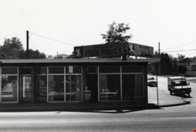
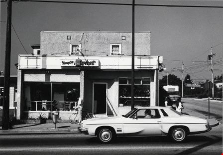
Paddy's Pizza Place
https://search.heritageburnaby.ca/link/archivedescription79328
- Repository
- City of Burnaby Archives
- Date
- September 16, 1976
- Collection/Fonds
- Burnaby Public Library Contemporary Visual Archive Project
- Description Level
- Item
- Physical Description
- 1 photograph : b&w ; 11 x 16 cm mounted on cardboard
- Scope and Content
- Photograph shows Paddy's Pizza Place, a restaurant located on Hastings Street at Grove Avenue, built in 1968.
- Repository
- City of Burnaby Archives
- Date
- September 16, 1976
- Collection/Fonds
- Burnaby Public Library Contemporary Visual Archive Project
- Physical Description
- 1 photograph : b&w ; 11 x 16 cm mounted on cardboard
- Description Level
- Item
- Record No.
- 556-244
- Access Restriction
- No restrictions
- Reproduction Restriction
- Reproduce for fair dealing purposes only
- Accession Number
- 2013-13
- Scope and Content
- Photograph shows Paddy's Pizza Place, a restaurant located on Hastings Street at Grove Avenue, built in 1968.
- Subjects
- Buildings - Commercial - Restaurants
- Names
- Paddy's Pizza Place
- Media Type
- Photograph
- Photographer
- Born, A. J.
- Notes
- Scope note taken directly from BPL photograph description.
- 1 b&w copy negative : 10 x 12.5 cm accompanying
- Geographic Access
- Hastings Street
- Grove Avenue
- Historic Neighbourhood
- Lochdale (Historic Neighbourhood)
- Planning Study Area
- Lochdale Area
Images

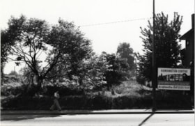
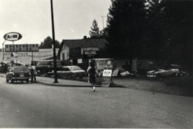
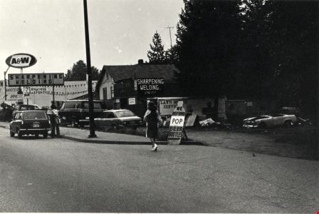
Vacant Lot
https://search.heritageburnaby.ca/link/archivedescription79340
- Repository
- City of Burnaby Archives
- Date
- September 20, 1976
- Collection/Fonds
- Burnaby Public Library Contemporary Visual Archive Project
- Description Level
- Item
- Physical Description
- 1 photograph : b&w ; 11 x 16 cm mounted on cardboard
- Scope and Content
- Photograph shows a vacant lot in the 6200 Block of Hastings Street. A sign indicates the lot is to be the site of Kensington Centre.
- Repository
- City of Burnaby Archives
- Date
- September 20, 1976
- Collection/Fonds
- Burnaby Public Library Contemporary Visual Archive Project
- Physical Description
- 1 photograph : b&w ; 11 x 16 cm mounted on cardboard
- Description Level
- Item
- Record No.
- 556-252
- Access Restriction
- No restrictions
- Reproduction Restriction
- Reproduce for fair dealing purposes only
- Accession Number
- 2013-13
- Scope and Content
- Photograph shows a vacant lot in the 6200 Block of Hastings Street. A sign indicates the lot is to be the site of Kensington Centre.
- Names
- Kensington Arena
- Media Type
- Photograph
- Photographer
- Born, A. J.
- Notes
- Scope note taken directly from BPL photograph description.
- 1 b&w copy negative : 10 x 12.5 cm accompanying
- Geographic Access
- Hastings Street
- Historic Neighbourhood
- Lochdale (Historic Neighbourhood)
- Planning Study Area
- Parkcrest-Aubrey Area
Images


Construction Project
https://search.heritageburnaby.ca/link/archivedescription79377
- Repository
- City of Burnaby Archives
- Date
- October 1, 1976
- Collection/Fonds
- Burnaby Public Library Contemporary Visual Archive Project
- Description Level
- Item
- Physical Description
- 1 photograph : b&w ; 11 x 16 cm mounted on cardboard
- Scope and Content
- Photograph shows a construction project by BC Hydro at Broadway and Cliff Avenue to bury transmission cables. The work was contracted to G.M. Gest Construction of Montreal.
- Repository
- City of Burnaby Archives
- Date
- October 1, 1976
- Collection/Fonds
- Burnaby Public Library Contemporary Visual Archive Project
- Physical Description
- 1 photograph : b&w ; 11 x 16 cm mounted on cardboard
- Description Level
- Item
- Record No.
- 556-271
- Access Restriction
- No restrictions
- Reproduction Restriction
- Reproduce for fair dealing purposes only
- Accession Number
- 2013-13
- Scope and Content
- Photograph shows a construction project by BC Hydro at Broadway and Cliff Avenue to bury transmission cables. The work was contracted to G.M. Gest Construction of Montreal.
- Media Type
- Photograph
- Photographer
- Born, A. J.
- Notes
- Scope note taken directly from BPL photograph description.
- 1 b&w copy negative : 10 x 12.5 cm accompanying
- Geographic Access
- Broadway
- Cliff Avenue
- Planning Study Area
- Sperling-Broadway Area
Images

Cablevision Worker
https://search.heritageburnaby.ca/link/archivedescription79446
- Repository
- City of Burnaby Archives
- Date
- September 7, 1976
- Collection/Fonds
- Burnaby Public Library Contemporary Visual Archive Project
- Description Level
- Item
- Physical Description
- 1 photograph : b&w ; 11 x 16 cm mounted on cardboard
- Scope and Content
- Photograph shows a Cablevision worker and truck at the corner of Buckingham Drive and Burris Street.
- Repository
- City of Burnaby Archives
- Date
- September 7, 1976
- Collection/Fonds
- Burnaby Public Library Contemporary Visual Archive Project
- Physical Description
- 1 photograph : b&w ; 11 x 16 cm mounted on cardboard
- Description Level
- Item
- Record No.
- 556-298
- Access Restriction
- No restrictions
- Reproduction Restriction
- Reproduce for fair dealing purposes only
- Accession Number
- 2013-13
- Scope and Content
- Photograph shows a Cablevision worker and truck at the corner of Buckingham Drive and Burris Street.
- Subjects
- Transportation - Trucks
- Media Type
- Photograph
- Photographer
- Born, A. J.
- Notes
- Scope note taken directly from BPL photograph description.
- 1 b&w copy negative : 10 x 12.5 cm accompanying
- Geographic Access
- Buckingham Drive
- Burris Street
- Historic Neighbourhood
- Burnaby Lake (Historic Neighbourhood)
- Planning Study Area
- Morley-Buckingham Area
Images


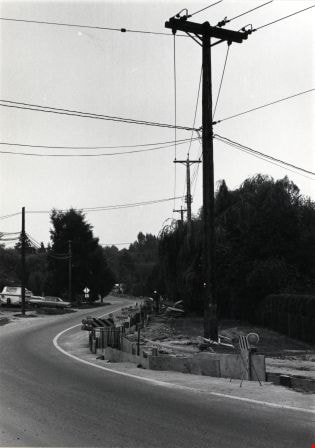
Construction Sign
https://search.heritageburnaby.ca/link/archivedescription79447
- Repository
- City of Burnaby Archives
- Date
- September 24, 1976
- Collection/Fonds
- Burnaby Public Library Contemporary Visual Archive Project
- Description Level
- Item
- Physical Description
- 1 photograph : b&w ; 11 x 16 cm mounted on cardboard
- Scope and Content
- Photograph shows an "obstruction ahead" sign put down by BC Hydro crew, who can be seen working in the background, near Sperling and Canada Way.
- Repository
- City of Burnaby Archives
- Date
- September 24, 1976
- Collection/Fonds
- Burnaby Public Library Contemporary Visual Archive Project
- Physical Description
- 1 photograph : b&w ; 11 x 16 cm mounted on cardboard
- Description Level
- Item
- Record No.
- 556-299
- Access Restriction
- No restrictions
- Reproduction Restriction
- Reproduce for fair dealing purposes only
- Accession Number
- 2013-13
- Scope and Content
- Photograph shows an "obstruction ahead" sign put down by BC Hydro crew, who can be seen working in the background, near Sperling and Canada Way.
- Media Type
- Photograph
- Photographer
- Born, A. J.
- Notes
- Scope note taken directly from BPL photograph description.
- 1 b&w copy negative : 10 x 12.5 cm accompanying
- Geographic Access
- Sperling Avenue
- Canada Way
- Historic Neighbourhood
- Burnaby Lake (Historic Neighbourhood)
- Planning Study Area
- Morley-Buckingham Area
Images

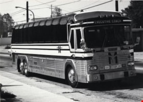
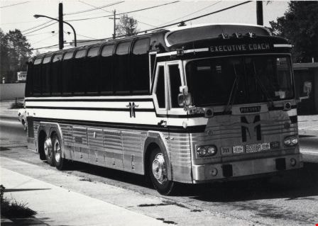
Executive Coach
https://search.heritageburnaby.ca/link/archivedescription79483
- Repository
- City of Burnaby Archives
- Date
- September 16, 1976
- Collection/Fonds
- Burnaby Public Library Contemporary Visual Archive Project
- Description Level
- Item
- Physical Description
- 1 photograph : b&w ; 11 x 16 cm mounted on cardboard
- Scope and Content
- Photograph shows Executive Coach owned by Maverick Coach Lines Ltd., parked on Edmonds Street.
- Repository
- City of Burnaby Archives
- Date
- September 16, 1976
- Collection/Fonds
- Burnaby Public Library Contemporary Visual Archive Project
- Physical Description
- 1 photograph : b&w ; 11 x 16 cm mounted on cardboard
- Description Level
- Item
- Record No.
- 556-315
- Access Restriction
- No restrictions
- Reproduction Restriction
- Reproduce for fair dealing purposes only
- Accession Number
- 2013-13
- Scope and Content
- Photograph shows Executive Coach owned by Maverick Coach Lines Ltd., parked on Edmonds Street.
- Subjects
- Transportation - Buses
- Media Type
- Photograph
- Photographer
- Born, A. J.
- Notes
- Scope note taken directly from BPL photograph description.
- 1 b&w copy negative : 10 x 12.5 cm accompanying
- Geographic Access
- Edmonds Street
Images