Narrow Results By
Creator
- Aitkenhead, May 1
- British Columbia Underwriters' Association
- Burnaby Village Museum 1
- Damer, Eric 1
- Dunlop, John 1
- Hawkshaw, Mabel Edith Honor McClean 4
- McAllister, Kenneth "Ken" 1
- McGeachie, Ivy Ashliegh
- Plan Department, British Columbia Insurance Underwriters' Association 1
- Stanley, Esther Love 1
- Walker, Bea 1
- Wilson, Elsie B. 1
Girl Guiding
https://search.heritageburnaby.ca/link/museumdescription4588
- Repository
- Burnaby Village Museum
- Date
- 1939-1951
- Collection/Fonds
- Burnaby Girl Guides fonds
- Description Level
- File
- Physical Description
- 1 scrapbook album (99 photographs+ textual records + other material)
- Scope and Content
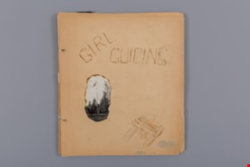
- File consists of 18 loose pages of a scrapbook created by Ivy McGeachie (nee Ivy Oldham) who was involved in guiding in Burnaby between 1942 -1948. The front page of the scrapbook is titled “Girl / Guiding” and has a wood-burnt image of a camp fire and a singed photo of a flag pole. The scrapbook …
- Repository
- Burnaby Village Museum
- Collection/Fonds
- Burnaby Girl Guides fonds
- Description Level
- File
- Physical Description
- 1 scrapbook album (99 photographs+ textual records + other material)
- Scope and Content
- File consists of 18 loose pages of a scrapbook created by Ivy McGeachie (nee Ivy Oldham) who was involved in guiding in Burnaby between 1942 -1948. The front page of the scrapbook is titled “Girl / Guiding” and has a wood-burnt image of a camp fire and a singed photo of a flag pole. The scrapbook contains photographs along with bits and pieces of ephemera. Included in the material is a four page, type-written diary of a Girl Guide camp held at Aldergrove Beach in August of 1963. Many of the photographs document the activities of the 2nd Burnaby Girl Guide Company and include photos of Ivy and Margaret McGeachie in uniform on roller skates; Burnaby District Camp (Aldergrove, BC) / 1948; Hiking; Canadian Girl Guide Golden Jubilee; Open House at St. Alban’s church hall; a hand tinted photo of Ivy McGeachie 1939 and the 2nd Kamloops Folk Dance – Yale Cariboo Musical festival 1951.
- Creator
- McGeachie, Ivy Ashliegh
- Accession Code
- BV015.35.160
- Access Restriction
- No restrictions
- Reproduction Restriction
- May be restricted by third party rights
- Date
- 1939-1951
- Media Type
- Photograph
- Textual Record
- Notes
- Title based on content of file
- Some photographs within scrapbook have been described at item level (BV015.35.191 to BV015.35.210)
Images

Documents
![Municipality of Burnaby - Volume XV and Volume XVIII, 1927-[1940] thumbnail](/media/hpo/_Data/_BVM_Artifacts/1972/1972_0111_0004_003.jpg?width=280)
Municipality of Burnaby - Volume XV and Volume XVIII
https://search.heritageburnaby.ca/link/museumdescription8682
- Repository
- Burnaby Village Museum
- Date
- 1927-[1940]
- Collection/Fonds
- Burnaby Village Museum Map collection
- Description Level
- File
- Physical Description
- 4 plans on 4 sheets: col. lithographic prints ; 63.5 x 53.5 cm folded to 53 x 31.5 cm
- Scope and Content
- File consists of four pages of plans removed from a bound book containing a series of fire insurance plans of the Municipality of Burnaby. Plan "1518" and "1519" are from "GREATER VANCOUVER B.C. / VOLUME XV / Municipality of Burnaby / May, 1927". Plan "1518" covers District Lot 116 and Plan "1519"…
- Repository
- Burnaby Village Museum
- Collection/Fonds
- Burnaby Village Museum Map collection
- Description Level
- File
- Physical Description
- 4 plans on 4 sheets: col. lithographic prints ; 63.5 x 53.5 cm folded to 53 x 31.5 cm
- Material Details
- Scale [1:600]
- Scope and Content
- File consists of four pages of plans removed from a bound book containing a series of fire insurance plans of the Municipality of Burnaby. Plan "1518" and "1519" are from "GREATER VANCOUVER B.C. / VOLUME XV / Municipality of Burnaby / May, 1927". Plan "1518" covers District Lot 116 and Plan "1519" covers District Lot 121. Plan "1802" and plan "1803" are from "GREATER VANCOUVER B.C. / VOLUME XVIII / Municipality of Burnaby / May, 1927". Both plans "1802" and "1803" cover District Lot 153.
- Responsibility
- British Columbia Underwriters' Association
- Accession Code
- HV972.111.4
- Access Restriction
- No restrictions
- Reproduction Restriction
- May be restricted by third party rights
- Date
- 1927-[1940]
- Media Type
- Cartographic Material
- Historic Neighbourhood
- Vancouver Heights (Historic Neighbourhood)
- Central Park (Historic Neighbourhood)
- Planning Study Area
- Willingdon Heights Area
- Marlborough Area
- Scan Resolution
- 400
- Scan Date
- 2021-11-18
- Notes
- Title based on content of plans
- See also BV987.1.70d for revised versions of plans
- Scale is measured 1 inch = 50 feet
- Contact Burnaby Village Museum to access plans 1518 and 1519 (these plans have revisions on top - date of revisions is uncertain)
Images
![Municipality of Burnaby - Volume XV and Volume XVIII, 1927-[1940] thumbnail](/media/hpo/_Data/_BVM_Artifacts/1972/1972_0111_0004_003.jpg)
