Narrow Results By
Decade
- 2020s
- 2010s 150
- 2000s 1408
- 1990s 2318
- 1980s 1042
- 1970s 2082
- 1960s 1180
- 1950s 1287
- 1940s 1403
- 1930s
- 1920s 1711
- 1910s 1275
- 1900s 438
- 1890s 151
- 1880s 136
- 1870s 62
- 1860s 108
- 1850s 8
- 1840s 3
- 1830s 2
- 1820s 2
- 1810s 3
- 1800s 3
- 1790s 2
- 1780s 2
- 1770s 2
- 1760s 2
- 1750s 2
- 1740s 2
- 1730s 2
- 1720s 2
- 1710s 2
- 1700s 2
- 1690s 2
- 1680s 2
- 1670s 1
- 1660s 1
- 1650s 1
- 1640s 1
- 1630s 1
- 1620s 1
- 1610s 1
- 1600s 1
- 1590s 1
- 1580s 1
- 1570s 1
- 1560s 1
- 1550s 1
- 1540s 1
- 1530s 1
- 1520s 1
- 1510s 1
- 1500s 1
- 1490s 1
- 1480s 1
Subject
- Accidents 4
- Accidents - Automobile Accidents 1
- Advertising Medium - Signs and Signboards 38
- Aerial Photographs 1
- Agricultural Tools and Equipment 2
- Agricultural Tools and Equipment - Gardening Equipment 2
- Agricultural Tools and Equipment - Plows 1
- Agriculture 2
- Agriculture - Crops 2
- Agriculture - Farms 16
- Agriculture - Fruit and Berries 3
- Animals 1

50-Foot High Stump
https://search.heritageburnaby.ca/link/archivedescription36668
- Repository
- City of Burnaby Archives
- Date
- 1936 (date of original), copied 1992
- Collection/Fonds
- Burnaby Historical Society fonds
- Description Level
- Item
- Physical Description
- 1 photograph : b&w ; 12.5 x 8.5 cm print
- Scope and Content
- Photograph of a stump in Central Park. Typed note at the bottom of the photograph reads, "Hollow stump in Central Park (about centre of park). Fifty feet high. At five feet from ground, fifty feet in circumference as measured by Mr. and Mrs. R.T. Wilson. Central Park, November 1936. / City Archiv…
- Repository
- City of Burnaby Archives
- Date
- 1936 (date of original), copied 1992
- Collection/Fonds
- Burnaby Historical Society fonds
- Subseries
- Burnaby Centennial Anthology subseries
- Physical Description
- 1 photograph : b&w ; 12.5 x 8.5 cm print
- Description Level
- Item
- Record No.
- 315-023
- Access Restriction
- No restrictions
- Reproduction Restriction
- No known restrictions
- Accession Number
- BHS1994-04
- Scope and Content
- Photograph of a stump in Central Park. Typed note at the bottom of the photograph reads, "Hollow stump in Central Park (about centre of park). Fifty feet high. At five feet from ground, fifty feet in circumference as measured by Mr. and Mrs. R.T. Wilson. Central Park, November 1936. / City Archives."
- Media Type
- Photograph
- Notes
- Title based on contents of photograph
- Geographic Access
- Central Park
- Imperial Street
- Street Address
- 3883 Imperial Street
- Historic Neighbourhood
- Central Park (Historic Neighbourhood)
- Planning Study Area
- Maywood Area
Images

![311 Madison Avenue, [1931] (date of original), copied 1991 thumbnail](/media/hpo/_Data/_Archives_Images/_Unrestricted/370/370-203.jpg?width=280)
311 Madison Avenue
https://search.heritageburnaby.ca/link/archivedescription37615
- Repository
- City of Burnaby Archives
- Date
- [1931] (date of original), copied 1991
- Collection/Fonds
- Burnaby Historical Society fonds
- Description Level
- Item
- Physical Description
- 1 photograph : b&w ; 3.0 x 4.5 cm print on contact sheet 20.2 x 25.3 cm
- Scope and Content
- Photograph of 311 Madison Avenue; a side view of the house before it was covered in stucco.
- Repository
- City of Burnaby Archives
- Date
- [1931] (date of original), copied 1991
- Collection/Fonds
- Burnaby Historical Society fonds
- Subseries
- Burnaby Image Bank subseries
- Physical Description
- 1 photograph : b&w ; 3.0 x 4.5 cm print on contact sheet 20.2 x 25.3 cm
- Description Level
- Item
- Record No.
- 370-203
- Access Restriction
- No restrictions
- Reproduction Restriction
- No known restrictions
- Accession Number
- BHS1999-03
- Scope and Content
- Photograph of 311 Madison Avenue; a side view of the house before it was covered in stucco.
- Subjects
- Buildings - Residential - Houses
- Media Type
- Photograph
- Notes
- Title based on contents of photograph
- 1 b&w copy negative accompanying
- Geographic Access
- Madison Avenue
- Street Address
- 311 Madison Avenue
- Historic Neighbourhood
- Vancouver Heights (Historic Neighbourhood)
- Planning Study Area
- Burnaby Heights Area
Images
![311 Madison Avenue, [1931] (date of original), copied 1991 thumbnail](/media/hpo/_Data/_Archives_Images/_Unrestricted/370/370-203.jpg)
![515 Esmond Street North, [bewteen 1935 and 1939] (date of original), copied 1991 thumbnail](/media/hpo/_Data/_Archives_Images/_Unrestricted/370/370-132.jpg?width=280)
515 Esmond Street North
https://search.heritageburnaby.ca/link/archivedescription37544
- Repository
- City of Burnaby Archives
- Date
- [bewteen 1935 and 1939] (date of original), copied 1991
- Collection/Fonds
- Burnaby Historical Society fonds
- Description Level
- Item
- Physical Description
- 1 photograph : b&w ; 2.8 x 4.3 cm print on contact sheet 20.2 x 25.3 cm
- Scope and Content
- Photograph of 515 Esmond Street North.
- Repository
- City of Burnaby Archives
- Date
- [bewteen 1935 and 1939] (date of original), copied 1991
- Collection/Fonds
- Burnaby Historical Society fonds
- Subseries
- Burnaby Image Bank subseries
- Physical Description
- 1 photograph : b&w ; 2.8 x 4.3 cm print on contact sheet 20.2 x 25.3 cm
- Description Level
- Item
- Record No.
- 370-132
- Access Restriction
- No restrictions
- Reproduction Restriction
- No known restrictions
- Accession Number
- BHS1999-03
- Scope and Content
- Photograph of 515 Esmond Street North.
- Subjects
- Buildings - Residential - Houses
- Media Type
- Photograph
- Notes
- Title based on contents of photograph
- 1 b&w copy negative accompanying
- Photograph copied from a hand-coloured original
- Geographic Access
- Esmond Avenue North
- Street Address
- 515 Esmond Avenue North
- Historic Neighbourhood
- Vancouver Heights (Historic Neighbourhood)
- Planning Study Area
- Burnaby Heights Area
Images
![515 Esmond Street North, [bewteen 1935 and 1939] (date of original), copied 1991 thumbnail](/media/hpo/_Data/_Archives_Images/_Unrestricted/370/370-132.jpg)
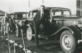
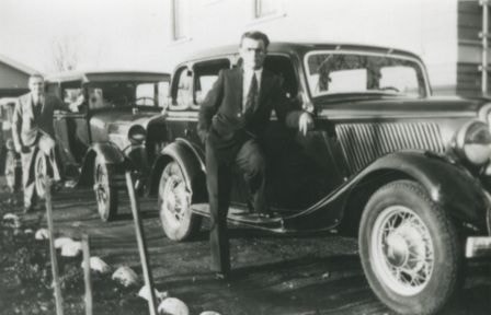
![1934 V-8 Ford, [1936 or 1937] (date of original), copied 1991 thumbnail](/media/hpo/_Data/_Archives_Images/_Unrestricted/370/370-669.jpg?width=280)
1934 V-8 Ford
https://search.heritageburnaby.ca/link/archivedescription38082
- Repository
- City of Burnaby Archives
- Date
- [1936 or 1937] (date of original), copied 1991
- Collection/Fonds
- Burnaby Historical Society fonds
- Description Level
- Item
- Physical Description
- 1 photograph : b&w ; 2.6 x 4.7 cm print on contact sheet 20.2 x 26.2 cm
- Scope and Content
- Photograph of a 1934 V-8 Ford in front of 3825 Hazel Street (later renumbered 4673 Hazel Street).
- Repository
- City of Burnaby Archives
- Date
- [1936 or 1937] (date of original), copied 1991
- Collection/Fonds
- Burnaby Historical Society fonds
- Subseries
- Burnaby Image Bank subseries
- Physical Description
- 1 photograph : b&w ; 2.6 x 4.7 cm print on contact sheet 20.2 x 26.2 cm
- Description Level
- Item
- Record No.
- 370-669
- Access Restriction
- No restrictions
- Reproduction Restriction
- No known restrictions
- Accession Number
- BHS1999-03
- Scope and Content
- Photograph of a 1934 V-8 Ford in front of 3825 Hazel Street (later renumbered 4673 Hazel Street).
- Subjects
- Transportation - Automobiles
- Media Type
- Photograph
- Notes
- Title based on contents of photograph
- 1 b&w copy negative accompanying
- Negative has a pink cast
- Geographic Access
- Hazel Street
- Street Address
- 4673 Hazel Street
- Historic Neighbourhood
- Central Park (Historic Neighbourhood)
- Planning Study Area
- Marlborough Area
Images
![1934 V-8 Ford, [1936 or 1937] (date of original), copied 1991 thumbnail](/media/hpo/_Data/_Archives_Images/_Unrestricted/370/370-669.jpg)
![1935 Ford, [193-?] (date of original), copied 1992 thumbnail](/media/hpo/_Data/_Archives_Images/_Unrestricted/315/315-343.jpg?width=280)
1935 Ford
https://search.heritageburnaby.ca/link/archivedescription36885
- Repository
- City of Burnaby Archives
- Date
- [193-?] (date of original), copied 1992
- Collection/Fonds
- Burnaby Historical Society fonds
- Description Level
- Item
- Physical Description
- 1 photograph : b&w ; 8.7 x 12.6 cm print
- Scope and Content
- Photograph of a woman standing beside a 1935 Ford decorated for an International Order of the Daughters of the Empire (I.O.D.E.) parade.
- Repository
- City of Burnaby Archives
- Date
- [193-?] (date of original), copied 1992
- Collection/Fonds
- Burnaby Historical Society fonds
- Subseries
- Burnaby Centennial Anthology subseries
- Physical Description
- 1 photograph : b&w ; 8.7 x 12.6 cm print
- Description Level
- Item
- Record No.
- 315-343
- Access Restriction
- No restrictions
- Reproduction Restriction
- No known restrictions
- Accession Number
- BHS1994-04
- Scope and Content
- Photograph of a woman standing beside a 1935 Ford decorated for an International Order of the Daughters of the Empire (I.O.D.E.) parade.
- Subjects
- Transportation - Automobiles
- Media Type
- Photograph
- Notes
- Title based on contents of photograph
Images
![1935 Ford, [193-?] (date of original), copied 1992 thumbnail](/media/hpo/_Data/_Archives_Images/_Unrestricted/315/315-343.jpg)
1935 Ford and 1918 "Tin Lizzie"
https://search.heritageburnaby.ca/link/archivedescription36886
- Repository
- City of Burnaby Archives
- Date
- [193-] (date of original), copied 1992
- Collection/Fonds
- Burnaby Historical Society fonds
- Description Level
- Item
- Physical Description
- 1 photograph : b&w ; 8.7 x 12.6 cm print
- Scope and Content
- Photograph of a George Grant with a 1935 Ford (right) and Bill Grant with a 1918 "Tin Lizzie" (left). The "Tin Lizzie" belonged to William Wright.
- Repository
- City of Burnaby Archives
- Date
- [193-] (date of original), copied 1992
- Collection/Fonds
- Burnaby Historical Society fonds
- Subseries
- Burnaby Centennial Anthology subseries
- Physical Description
- 1 photograph : b&w ; 8.7 x 12.6 cm print
- Description Level
- Item
- Record No.
- 315-344
- Access Restriction
- No restrictions
- Reproduction Restriction
- No known restrictions
- Accession Number
- BHS1994-04
- Scope and Content
- Photograph of a George Grant with a 1935 Ford (right) and Bill Grant with a 1918 "Tin Lizzie" (left). The "Tin Lizzie" belonged to William Wright.
- Subjects
- Transportation - Automobiles
- Media Type
- Photograph
- Notes
- Title based on contents of photograph
Images
![1935 Ford in the Snow, [193-?] (date of original), copied 1992 thumbnail](/media/hpo/_Data/_Archives_Images/_Unrestricted/315/315-373.jpg?width=280)
1935 Ford in the Snow
https://search.heritageburnaby.ca/link/archivedescription36915
- Repository
- City of Burnaby Archives
- Date
- [193-?] (date of original), copied 1992
- Collection/Fonds
- Burnaby Historical Society fonds
- Description Level
- Item
- Physical Description
- 1 photograph : b&w ; 8.8 x 12.7 cm print
- Scope and Content
- Photograph of a 1935 Ford beside a snow bank.
- Repository
- City of Burnaby Archives
- Date
- [193-?] (date of original), copied 1992
- Collection/Fonds
- Burnaby Historical Society fonds
- Subseries
- Burnaby Centennial Anthology subseries
- Physical Description
- 1 photograph : b&w ; 8.8 x 12.7 cm print
- Description Level
- Item
- Record No.
- 315-373
- Access Restriction
- No restrictions
- Reproduction Restriction
- No known restrictions
- Accession Number
- BHS1994-04
- Scope and Content
- Photograph of a 1935 Ford beside a snow bank.
- Media Type
- Photograph
- Notes
- Title based on contents of photograph
Images
![1935 Ford in the Snow, [193-?] (date of original), copied 1992 thumbnail](/media/hpo/_Data/_Archives_Images/_Unrestricted/315/315-373.jpg)
![3700 Block Yale Street, [between 1930 and 1934] (date of original), copied 1991 thumbnail](/media/hpo/_Data/_Archives_Images/_Unrestricted/370/370-139.jpg?width=280)
3700 Block Yale Street
https://search.heritageburnaby.ca/link/archivedescription37551
- Repository
- City of Burnaby Archives
- Date
- [between 1930 and 1934] (date of original), copied 1991
- Collection/Fonds
- Burnaby Historical Society fonds
- Description Level
- Item
- Physical Description
- 1 photograph : b&w ; 2.8 x 4.8 cm print on contact sheet 20.2 x 25.3 cm
- Scope and Content
- Photograph of the 3700 block of Yale Street. At the left is a side view of 515 Esmond Avenue North.
- Repository
- City of Burnaby Archives
- Date
- [between 1930 and 1934] (date of original), copied 1991
- Collection/Fonds
- Burnaby Historical Society fonds
- Subseries
- Burnaby Image Bank subseries
- Physical Description
- 1 photograph : b&w ; 2.8 x 4.8 cm print on contact sheet 20.2 x 25.3 cm
- Description Level
- Item
- Record No.
- 370-139
- Access Restriction
- No restrictions
- Reproduction Restriction
- No known restrictions
- Accession Number
- BHS1999-03
- Scope and Content
- Photograph of the 3700 block of Yale Street. At the left is a side view of 515 Esmond Avenue North.
- Subjects
- Geographic Features - Gardens
- Media Type
- Photograph
- Notes
- Title based on contents of photograph
- 1 b&w copy negative accompanying
- Geographic Access
- Yale Street
- Historic Neighbourhood
- Vancouver Heights (Historic Neighbourhood)
- Planning Study Area
- Burnaby Heights Area
Images
![3700 Block Yale Street, [between 1930 and 1934] (date of original), copied 1991 thumbnail](/media/hpo/_Data/_Archives_Images/_Unrestricted/370/370-139.jpg)

3955 Moscrop Street
https://search.heritageburnaby.ca/link/archivedescription98654
- Repository
- City of Burnaby Archives
- Date
- 2021
- Collection/Fonds
- Disappearing Burnaby collection
- Description Level
- Item
- Physical Description
- 1 photograph (jpeg) : col.
- Scope and Content
- Photograph of the exterior of a house located at 3955 Moscrop Street. The house was constructed in 1954. The photograph depicts the house at night, with the house's porch light on, and a car is in the driveway in front of the house.
- Repository
- City of Burnaby Archives
- Date
- 2021
- Collection/Fonds
- Disappearing Burnaby collection
- Physical Description
- 1 photograph (jpeg) : col.
- Description Level
- Item
- Record No.
- 634-001
- Access Restriction
- No restrictions
- Reproduction Restriction
- No restrictions
- Accession Number
- 2022-14
- Scope and Content
- Photograph of the exterior of a house located at 3955 Moscrop Street. The house was constructed in 1954. The photograph depicts the house at night, with the house's porch light on, and a car is in the driveway in front of the house.
- Media Type
- Photograph
- Photographer
- Cheung, Nakita
- Notes
- Title taken from the associated blog post
- Associated blog post: https://disappearingburnaby.wordpress.com/2022/02/24/moscrop-house/
- Geographic Access
- Moscrop Street
- Street Address
- 3955 Moscrop Street
- Historic Neighbourhood
- Broadview (Historic Neighbourhood)
- Planning Study Area
- Cascade-Schou Area
Images

5118 Douglas Road landscaping plan
https://search.heritageburnaby.ca/link/archivedescription91895
- Repository
- City of Burnaby Archives
- Date
- ca. 1931
- Collection/Fonds
- Small family fonds
- Description Level
- Item
- Physical Description
- 1 technical drawing : ink and pencil on paper ; 61 cm x 49 cm
- Scope and Content
- Item is a landscaping plan for the property at 5118 Douglas Street, with individual trees plotted and their species identified.
- Repository
- City of Burnaby Archives
- Date
- ca. 1931
- Collection/Fonds
- Small family fonds
- Physical Description
- 1 technical drawing : ink and pencil on paper ; 61 cm x 49 cm
- Material Details
- Scale : 1/8" = 1'
- Description Level
- Item
- Record No.
- 60633
- Access Restriction
- Open access
- Accession Number
- 2017-01
- Scope and Content
- Item is a landscaping plan for the property at 5118 Douglas Street, with individual trees plotted and their species identified.
- Media Type
- Technical Drawing

5130 Irving Street
https://search.heritageburnaby.ca/link/archivedescription98671
- Repository
- City of Burnaby Archives
- Date
- 2022
- Collection/Fonds
- Disappearing Burnaby collection
- Description Level
- Item
- Physical Description
- 1 photograph (jpeg) : col.
- Scope and Content
- Photograph of the front steps and the entrance of a three-storey apartment building located at 5130 Irving Street. The photograph depicts the building at night, with the lobby and some of the apartments' windows illuminated from inside. The building was constructed in 1971.
- Repository
- City of Burnaby Archives
- Date
- 2022
- Collection/Fonds
- Disappearing Burnaby collection
- Physical Description
- 1 photograph (jpeg) : col.
- Description Level
- Item
- Record No.
- 634-018
- Access Restriction
- No restrictions
- Reproduction Restriction
- No restrictions
- Accession Number
- 2022-14
- Scope and Content
- Photograph of the front steps and the entrance of a three-storey apartment building located at 5130 Irving Street. The photograph depicts the building at night, with the lobby and some of the apartments' windows illuminated from inside. The building was constructed in 1971.
- Media Type
- Photograph
- Photographer
- Cheung, Nakita
- Notes
- Title taken from the associated blog post
- Associated blog post: https://disappearingburnaby.wordpress.com/2022/05/04/e-just-e/
- Geographic Access
- Irving Street
- Street Address
- 5130 Irving Street
- Historic Neighbourhood
- Central Park (Historic Neighbourhood)
- Planning Study Area
- Marlborough Area
Images


5130 Irving Street lobby
https://search.heritageburnaby.ca/link/archivedescription98672
- Repository
- City of Burnaby Archives
- Date
- 2022
- Collection/Fonds
- Disappearing Burnaby collection
- Description Level
- Item
- Physical Description
- 1 photograph (jpeg) : col.
- Scope and Content
- Photograph of the entrance of an apartment building located at 5130 Irving Street. The building was constructed in 1971. The photograph depicts the entrance and the lobby from the exterior at night. The lobby is illuminated and a crest featuring an "E" is on the entrance window.
- Repository
- City of Burnaby Archives
- Date
- 2022
- Collection/Fonds
- Disappearing Burnaby collection
- Physical Description
- 1 photograph (jpeg) : col.
- Description Level
- Item
- Record No.
- 634-019
- Access Restriction
- No restrictions
- Reproduction Restriction
- No restrictions
- Accession Number
- 2022-14
- Scope and Content
- Photograph of the entrance of an apartment building located at 5130 Irving Street. The building was constructed in 1971. The photograph depicts the entrance and the lobby from the exterior at night. The lobby is illuminated and a crest featuring an "E" is on the entrance window.
- Media Type
- Photograph
- Photographer
- Cheung, Nakita
- Notes
- Title taken from the associated blog post
- Associated blog post: https://disappearingburnaby.wordpress.com/2022/05/04/e-just-e/
- Geographic Access
- Irving Street
- Street Address
- 5130 Irving Street
- Historic Neighbourhood
- Central Park (Historic Neighbourhood)
- Planning Study Area
- Marlborough Area
Images


5990 Irmin Street
https://search.heritageburnaby.ca/link/archivedescription98685
- Repository
- City of Burnaby Archives
- Date
- 2022
- Collection/Fonds
- Disappearing Burnaby collection
- Description Level
- Item
- Physical Description
- 1 photograph (jpeg) : col.
- Scope and Content
- Photograph of a multi-storey house located at 5990 Irmin Street. The photograph depicts of the exterior of the house at dusk; a light is on in one of the house's rooms and a vehicle is parked in the house's driveway next to a portable garage. A "For Sale" sign on the edge of the property reads: "Fu…
- Repository
- City of Burnaby Archives
- Date
- 2022
- Collection/Fonds
- Disappearing Burnaby collection
- Physical Description
- 1 photograph (jpeg) : col.
- Description Level
- Item
- Record No.
- 634-032
- Access Restriction
- No restrictions
- Reproduction Restriction
- No restrictions
- Accession Number
- 2022-14
- Scope and Content
- Photograph of a multi-storey house located at 5990 Irmin Street. The photograph depicts of the exterior of the house at dusk; a light is on in one of the house's rooms and a vehicle is parked in the house's driveway next to a portable garage. A "For Sale" sign on the edge of the property reads: "Future Development Land." Another house is visible in the background. The house was constructed in 1923 and is nearby to 7530 Buller Avenue.
- Media Type
- Photograph
- Photographer
- Cheung, Nakita
- Notes
- Title taken from the associated blog post
- Associated blog post: https://disappearingburnaby.wordpress.com/2022/06/30/william-esther-burdick-residence/
- Geographic Access
- Irmin Street
- Street Address
- 5990 Irmin Street
- Historic Neighbourhood
- Alta Vista (Historic Neighbourhood)
- Planning Study Area
- Clinton-Glenwood Area
Images


6280 Marlborough Avenue
https://search.heritageburnaby.ca/link/archivedescription98673
- Repository
- City of Burnaby Archives
- Date
- 2022
- Collection/Fonds
- Disappearing Burnaby collection
- Description Level
- Item
- Physical Description
- 1 photograph (jpeg) : col.
- Scope and Content
- Photograph of the front steps and entry to a three-storey apartment building, located at 6280 Marlborough Avenue. The photograph depicts the building at night and shows the brick building's details, including its lion statues and busts along the stair railings and the curved arches in front of the …
- Repository
- City of Burnaby Archives
- Date
- 2022
- Collection/Fonds
- Disappearing Burnaby collection
- Physical Description
- 1 photograph (jpeg) : col.
- Description Level
- Item
- Record No.
- 634-020
- Access Restriction
- No restrictions
- Reproduction Restriction
- No restrictions
- Accession Number
- 2022-14
- Scope and Content
- Photograph of the front steps and entry to a three-storey apartment building, located at 6280 Marlborough Avenue. The photograph depicts the building at night and shows the brick building's details, including its lion statues and busts along the stair railings and the curved arches in front of the front windows and door. The building was constructed in 1973.
- Media Type
- Photograph
- Photographer
- Cheung, Nakita
- Notes
- Title taken from the associated blog post
- Associated blog post: https://disappearingburnaby.wordpress.com/2022/05/12/marlborough-ave/
- Geographic Access
- Marlborough Avenue
- Street Address
- 6280 Marlborough Avenue
- Historic Neighbourhood
- Central Park (Historic Neighbourhood)
- Planning Study Area
- Marlborough Area
Images


6410 Denbigh Avenue
https://search.heritageburnaby.ca/link/archivedescription98667
- Repository
- City of Burnaby Archives
- Date
- 2022
- Collection/Fonds
- Disappearing Burnaby collection
- Description Level
- Item
- Physical Description
- 1 photograph (jpeg) : col.
- Scope and Content
- Photograph of the exterior of a single-storey house located at 6410 Denbigh Avenue, taken from across the street at dusk. The house was constructed in 1949. Lights illuminate the front porch and the interior of one of the house's windows and there is a small amount of snow on the lawn in front of t…
- Repository
- City of Burnaby Archives
- Date
- 2022
- Collection/Fonds
- Disappearing Burnaby collection
- Physical Description
- 1 photograph (jpeg) : col.
- Description Level
- Item
- Record No.
- 634-014
- Access Restriction
- No restrictions
- Reproduction Restriction
- No restrictions
- Accession Number
- 2022-14
- Scope and Content
- Photograph of the exterior of a single-storey house located at 6410 Denbigh Avenue, taken from across the street at dusk. The house was constructed in 1949. Lights illuminate the front porch and the interior of one of the house's windows and there is a small amount of snow on the lawn in front of the house.
- Media Type
- Photograph
- Photographer
- Cheung, Nakita
- Notes
- Title taken from the associated blog post
- Associated blog post: https://disappearingburnaby.wordpress.com/2022/05/15/denbigh-ave/
- Geographic Access
- Denbigh Avenue
- Street Address
- 6410 Denbigh Avenue
- Historic Neighbourhood
- Central Park (Historic Neighbourhood)
- Planning Study Area
- Windsor Area
Images


6508 Silver Avenue
https://search.heritageburnaby.ca/link/archivedescription98678
- Repository
- City of Burnaby Archives
- Date
- 2022
- Collection/Fonds
- Disappearing Burnaby collection
- Description Level
- Item
- Physical Description
- 1 photograph (jpeg) : col.
- Scope and Content
- Photograph of the corner and side of the exterior of a concrete low-rise apartment building located at 6508 Silver Avenue. The photograph depicts the building at dusk. Some of the apartment windows are lit up from inside, and plant pots are lined up along the third-floor balcony. A chain link fence…
- Repository
- City of Burnaby Archives
- Date
- 2022
- Collection/Fonds
- Disappearing Burnaby collection
- Physical Description
- 1 photograph (jpeg) : col.
- Description Level
- Item
- Record No.
- 634-025
- Access Restriction
- No restrictions
- Reproduction Restriction
- No restrictions
- Accession Number
- 2022-14
- Scope and Content
- Photograph of the corner and side of the exterior of a concrete low-rise apartment building located at 6508 Silver Avenue. The photograph depicts the building at dusk. Some of the apartment windows are lit up from inside, and plant pots are lined up along the third-floor balcony. A chain link fence surrounds the backyard. The building was constructed in 1966.
- Media Type
- Photograph
- Photographer
- Cheung, Nakita
- Notes
- Title taken from the associated blog post
- Associated blog post: https://disappearingburnaby.wordpress.com/2022/06/30/brutalist/
- Geographic Access
- Silver Avenue
- Street Address
- 6508 Silver Avenue
- Historic Neighbourhood
- Central Park (Historic Neighbourhood)
- Planning Study Area
- Maywood Area
Images


6615 Telford Avenue
https://search.heritageburnaby.ca/link/archivedescription98674
- Repository
- City of Burnaby Archives
- Date
- 2022
- Collection/Fonds
- Disappearing Burnaby collection
- Description Level
- Item
- Physical Description
- 1 photograph (jpeg) : col.
- Scope and Content
- Photograph of the entrance, including the front steps and ramp, to a low-rise apartment building located at 6615 Telford Avenue. The building was constructed in 1964. The photograph depicts the building at night, and trees and bushes partially obscure the entrance. The building's lobby is illuminat…
- Repository
- City of Burnaby Archives
- Date
- 2022
- Collection/Fonds
- Disappearing Burnaby collection
- Physical Description
- 1 photograph (jpeg) : col.
- Description Level
- Item
- Record No.
- 634-021
- Access Restriction
- No restrictions
- Reproduction Restriction
- No restrictions
- Accession Number
- 2022-14
- Scope and Content
- Photograph of the entrance, including the front steps and ramp, to a low-rise apartment building located at 6615 Telford Avenue. The building was constructed in 1964. The photograph depicts the building at night, and trees and bushes partially obscure the entrance. The building's lobby is illuminated and the apartments' mailboxes are visible through the window.
- Media Type
- Photograph
- Photographer
- Cheung, Nakita
- Notes
- Title taken from the associated blog post
- Associated blog post: https://disappearingburnaby.wordpress.com/2022/06/09/martello-group/
- Geographic Access
- Telford Avenue
- Street Address
- 6615 Telford Avenue
- Historic Neighbourhood
- Central Park (Historic Neighbourhood)
- Planning Study Area
- Maywood Area
Images


6692 Dow Avenue
https://search.heritageburnaby.ca/link/archivedescription98662
- Repository
- City of Burnaby Archives
- Date
- 2022
- Collection/Fonds
- Disappearing Burnaby collection
- Description Level
- Item
- Physical Description
- 1 photograph (jpeg) : col.
- Scope and Content
- Photograph of the exterior of a two-storey apartment building located at 6692 Dow Avenue. The photograph depicts the building from across the street at night; the lobby and some of the apartment windows are lit up, with a bunch of balloons in one window, and a car is parked on the street in front o…
- Repository
- City of Burnaby Archives
- Date
- 2022
- Collection/Fonds
- Disappearing Burnaby collection
- Physical Description
- 1 photograph (jpeg) : col.
- Description Level
- Item
- Record No.
- 634-009
- Access Restriction
- No restrictions
- Reproduction Restriction
- No restrictions
- Accession Number
- 2022-14
- Scope and Content
- Photograph of the exterior of a two-storey apartment building located at 6692 Dow Avenue. The photograph depicts the building from across the street at night; the lobby and some of the apartment windows are lit up, with a bunch of balloons in one window, and a car is parked on the street in front of the building. The building was constructed in 1959.
- Media Type
- Photograph
- Photographer
- Cheung, Nakita
- Notes
- Title taken from the associated blog post
- Associated blog post: https://disappearingburnaby.wordpress.com/2022/03/01/dow-ave/
- Geographic Access
- Dow Avenue
- Street Address
- 6692 Dow Avenue
- Historic Neighbourhood
- Central Park (Historic Neighbourhood)
- Planning Study Area
- Maywood Area
Images


6700 Dow Avenue
https://search.heritageburnaby.ca/link/archivedescription98663
- Repository
- City of Burnaby Archives
- Date
- 2022
- Collection/Fonds
- Disappearing Burnaby collection
- Description Level
- Item
- Physical Description
- 1 photograph (jpeg) : col.
- Scope and Content
- Photograph of the entrance to an apartment building located at 6700 Dow Avenue. The photograph depicts the building at night; the lobby and stairs are illuminated by exterior and interior lights. The building was constructed in 1968.
- Repository
- City of Burnaby Archives
- Date
- 2022
- Collection/Fonds
- Disappearing Burnaby collection
- Physical Description
- 1 photograph (jpeg) : col.
- Description Level
- Item
- Record No.
- 634-010
- Access Restriction
- No restrictions
- Reproduction Restriction
- No restrictions
- Accession Number
- 2022-14
- Scope and Content
- Photograph of the entrance to an apartment building located at 6700 Dow Avenue. The photograph depicts the building at night; the lobby and stairs are illuminated by exterior and interior lights. The building was constructed in 1968.
- Media Type
- Photograph
- Photographer
- Cheung, Nakita
- Notes
- Title taken from the associated blog post
- Associated blog post: https://disappearingburnaby.wordpress.com/2022/03/29/no-pes/
- Geographic Access
- Dow Avenue
- Street Address
- 6700 Dow Avenue
- Historic Neighbourhood
- Central Park (Historic Neighbourhood)
- Planning Study Area
- Maywood Area
Images


7530 Buller Avenue
https://search.heritageburnaby.ca/link/archivedescription98686
- Repository
- City of Burnaby Archives
- Date
- 2022
- Collection/Fonds
- Disappearing Burnaby collection
- Description Level
- Item
- Physical Description
- 1 photograph (jpeg) : col.
- Scope and Content
- Photograph of the exterior of a two-storey house located at 7530 Buller Avenue. The photograph depicts the house at dusk; the house stands behind a wooden fence and is surrounded by trees. The house was constructed in 1924 and was formerly known as "Ryverbrae," the William & Esther Burdick Residenc…
- Repository
- City of Burnaby Archives
- Date
- 2022
- Collection/Fonds
- Disappearing Burnaby collection
- Physical Description
- 1 photograph (jpeg) : col.
- Description Level
- Item
- Record No.
- 634-033
- Access Restriction
- No restrictions
- Reproduction Restriction
- No restrictions
- Accession Number
- 2022-14
- Scope and Content
- Photograph of the exterior of a two-storey house located at 7530 Buller Avenue. The photograph depicts the house at dusk; the house stands behind a wooden fence and is surrounded by trees. The house was constructed in 1924 and was formerly known as "Ryverbrae," the William & Esther Burdick Residence.
- Media Type
- Photograph
- Photographer
- Cheung, Nakita
- Notes
- Title taken from the associated blog post
- Associated blog post: https://disappearingburnaby.wordpress.com/2022/06/30/william-esther-burdick-residence/
- Geographic Access
- Buller Avenue
- Street Address
- 7530 Buller Avenue
- Historic Neighbourhood
- Alta Vista (Historic Neighbourhood)
- Planning Study Area
- Clinton-Glenwood Area
Images
