Narrow Results By
Decade
- 2020s 224
- 2010s 149
- 2000s 1822
- 1990s 2868
- 1980s 1364
- 1970s
- 1960s 1352
- 1950s
- 1940s 2010
- 1930s
- 1920s 2345
- 1910s 1867
- 1900s 846
- 1890s 248
- 1880s 165
- 1870s 72
- 1860s 123
- 1850s 14
- 1840s 5
- 1830s 3
- 1820s 2
- 1810s 3
- 1800s 3
- 1790s 2
- 1780s 2
- 1770s 2
- 1760s 2
- 1750s 2
- 1740s 2
- 1730s 2
- 1720s 2
- 1710s 2
- 1700s 2
- 1690s 2
- 1680s 2
- 1670s 1
- 1660s 1
- 1650s 1
- 1640s 1
- 1630s 1
- 1620s 1
- 1610s 1
- 1600s 1
- 1590s 1
- 1580s 1
- 1570s 1
- 1560s 1
- 1550s 1
- 1540s 1
- 1530s 1
- 1520s 2
- 1510s 1
- 1500s 1
- 1490s 1
- 1480s 1
Subject
- Accidents 7
- Accidents - Automobile Accidents 8
- Accidents - Train Accidents 14
- Adminstrative Groups - Committees 4
- Adornment - Jewelry 3
- Advertising Medium 4
- Advertising Medium - Flyer 4
- Advertising Medium - Poster 15
- Advertising Medium - Signs and Signboards 103
- Aerial Photographs 65
- Agricultural Tools and Equipment 5
- Agricultural Tools and Equipment - Gardening Equipment 3
![3900 Albert Street - South Side, [196-] thumbnail](/media/hpo/_Data/_Archives_Images/_Unrestricted/316/366-027.jpg?width=280)
3900 Albert Street - South Side
https://search.heritageburnaby.ca/link/archivedescription97610
- Repository
- City of Burnaby Archives
- Date
- [196-]
- Collection/Fonds
- Burnaby Historical Society fonds
- Description Level
- Item
- Physical Description
- 1 photograph : b&w negative
- Scope and Content
- Photograph of two houses on the south corner of Albert Street and Ingleton Avenue at 3900 Albert Street.
- Repository
- City of Burnaby Archives
- Date
- [196-]
- Collection/Fonds
- Burnaby Historical Society fonds
- Subseries
- Municipal record subseries
- Physical Description
- 1 photograph : b&w negative
- Description Level
- Item
- Record No.
- 366-027
- Access Restriction
- No restrictions
- Reproduction Restriction
- Reproduce for fair dealing purposes only
- Accession Number
- BHS1998-12
- Scope and Content
- Photograph of two houses on the south corner of Albert Street and Ingleton Avenue at 3900 Albert Street.
- Subjects
- Buildings - Residential - Houses
- Media Type
- Photograph
- Notes
- Transcribed title
- Note on verso of photograph in black ink reads: "3900 Albert - South Side - Two Houses at East End of Block"
- Geographic Access
- Albert Street
- Street Address
- 3900 Albert Street
- Historic Neighbourhood
- Vancouver Heights (Historic Neighbourhood)
- Planning Study Area
- Burnaby Heights Area
Images
![3900 Albert Street - South Side, [196-] thumbnail](/media/hpo/_Data/_Archives_Images/_Unrestricted/316/366-027.jpg)
![3900 Block East Hastings businesses, [196-] thumbnail](/media/hpo/_Data/_Archives_Images/_Unrestricted/316/366-031.jpg?width=280)
3900 Block East Hastings businesses
https://search.heritageburnaby.ca/link/archivedescription97616
- Repository
- City of Burnaby Archives
- Date
- [196-]
- Collection/Fonds
- Burnaby Historical Society fonds
- Description Level
- Item
- Physical Description
- 1 photograph : b&w negative
- Scope and Content
- Photograph of the businesses along the north side of the 3900 block of East Hastings Street. Signs for the National Bakery at 3918 East Hastings and Tobin's Quality Shoes at 3972 East Hastings are visible. Photograph taken from the north side of Hastings facing west.
- Repository
- City of Burnaby Archives
- Date
- [196-]
- Collection/Fonds
- Burnaby Historical Society fonds
- Subseries
- Municipal record subseries
- Physical Description
- 1 photograph : b&w negative
- Description Level
- Item
- Record No.
- 366-031
- Access Restriction
- No restrictions
- Reproduction Restriction
- Reproduce for fair dealing purposes only
- Accession Number
- BHS1998-12
- Scope and Content
- Photograph of the businesses along the north side of the 3900 block of East Hastings Street. Signs for the National Bakery at 3918 East Hastings and Tobin's Quality Shoes at 3972 East Hastings are visible. Photograph taken from the north side of Hastings facing west.
- Subjects
- Buildings - Commercial - Stores
- Media Type
- Photograph
- Notes
- Title based on content of photograph
- Geographic Access
- Hastings Street
- Historic Neighbourhood
- Vancouver Heights (Historic Neighbourhood)
- Planning Study Area
- Burnaby Heights Area
Images
![3900 Block East Hastings businesses, [196-] thumbnail](/media/hpo/_Data/_Archives_Images/_Unrestricted/316/366-031.jpg)
![3900 Block East Hastings Street, [196-] thumbnail](/media/hpo/_Data/_Archives_Images/_Unrestricted/316/366-033-3.jpg?width=280)
3900 Block East Hastings Street
https://search.heritageburnaby.ca/link/archivedescription97618
- Repository
- City of Burnaby Archives
- Date
- [196-]
- Collection/Fonds
- Burnaby Historical Society fonds
- Description Level
- File
- Physical Description
- 3 photograph : b&w negatives
- Scope and Content
- Photographs of the rears of the businesses located along the 3900 block of East Hastings Street.
- Repository
- City of Burnaby Archives
- Date
- [196-]
- Collection/Fonds
- Burnaby Historical Society fonds
- Subseries
- Municipal record subseries
- Physical Description
- 3 photograph : b&w negatives
- Description Level
- File
- Record No.
- 366-033
- Access Restriction
- No restrictions
- Reproduction Restriction
- Reproduce for fair dealing purposes only
- Accession Number
- BHS1998-12
- Scope and Content
- Photographs of the rears of the businesses located along the 3900 block of East Hastings Street.
- Subjects
- Buildings - Commercial - Stores
- Media Type
- Photograph
- Notes
- Title based on content of photographs
- Geographic Access
- Hastings Street
- Historic Neighbourhood
- Vancouver Heights (Historic Neighbourhood)
- Planning Study Area
- Burnaby Heights Area
Images
![3900 Block East Hastings Street, [196-] thumbnail](/media/hpo/_Data/_Archives_Images/_Unrestricted/316/366-033-3.jpg)
![3900 Block of Hastings Street, [between 1965 and 1970] thumbnail](/media/hpo/_Data/_Archives_Images/_Unrestricted/316/366-009.jpg?width=280)
3900 Block of Hastings Street
https://search.heritageburnaby.ca/link/archivedescription37380
- Repository
- City of Burnaby Archives
- Date
- [between 1965 and 1970]
- Collection/Fonds
- Burnaby Historical Society fonds
- Description Level
- Item
- Physical Description
- 1 photograph : b&w negative
- Scope and Content
- Photograph looking west along the lane between the 3900 block of Hastings Street and Albert Street. An unidentified man is walking down the lane.
- Repository
- City of Burnaby Archives
- Date
- [between 1965 and 1970]
- Collection/Fonds
- Burnaby Historical Society fonds
- Subseries
- Municipal record subseries
- Physical Description
- 1 photograph : b&w negative
- Description Level
- Item
- Record No.
- 366-009
- Access Restriction
- No restrictions
- Reproduction Restriction
- Reproduce for fair dealing purposes only
- Accession Number
- BHS1998-12
- Scope and Content
- Photograph looking west along the lane between the 3900 block of Hastings Street and Albert Street. An unidentified man is walking down the lane.
- Subjects
- Geographic Features - Lanes
- Media Type
- Photograph
- Notes
- Title based on contents of photograph
- Geographic Access
- Hastings Street
- Historic Neighbourhood
- Vancouver Heights (Historic Neighbourhood)
- Planning Study Area
- Burnaby Heights Area
Images
![3900 Block of Hastings Street, [between 1965 and 1970] thumbnail](/media/hpo/_Data/_Archives_Images/_Unrestricted/316/366-009.jpg)
![3900 Hastings Street, [between 1965 and 1970] thumbnail](/media/hpo/_Data/_Archives_Images/_Unrestricted/316/366-010.jpg?width=280)
3900 Hastings Street
https://search.heritageburnaby.ca/link/archivedescription37381
- Repository
- City of Burnaby Archives
- Date
- [between 1965 and 1970]
- Collection/Fonds
- Burnaby Historical Society fonds
- Description Level
- Item
- Physical Description
- 1 photograph : b&w negative
- Scope and Content
- Photograph taken looking west along Hastings Street, in front of the 3900 Block.
- Repository
- City of Burnaby Archives
- Date
- [between 1965 and 1970]
- Collection/Fonds
- Burnaby Historical Society fonds
- Subseries
- Municipal record subseries
- Physical Description
- 1 photograph : b&w negative
- Description Level
- Item
- Record No.
- 366-010
- Access Restriction
- No restrictions
- Reproduction Restriction
- Reproduce for fair dealing purposes only
- Accession Number
- BHS1998-12
- Scope and Content
- Photograph taken looking west along Hastings Street, in front of the 3900 Block.
- Media Type
- Photograph
- Notes
- Title based on contents of photograph
- Geographic Access
- Hastings Street
- Historic Neighbourhood
- Vancouver Heights (Historic Neighbourhood)
- Planning Study Area
- Burnaby Heights Area
Images
![3900 Hastings Street, [between 1965 and 1970] thumbnail](/media/hpo/_Data/_Archives_Images/_Unrestricted/316/366-010.jpg)
![3901 Hastings Street, [between 1965 and 1970] thumbnail](/media/hpo/_Data/_Archives_Images/_Unrestricted/316/366-011.jpg?width=280)
3901 Hastings Street
https://search.heritageburnaby.ca/link/archivedescription37382
- Repository
- City of Burnaby Archives
- Date
- [between 1965 and 1970]
- Collection/Fonds
- Burnaby Historical Society fonds
- Description Level
- Item
- Physical Description
- 1 photograph : b&w negative
- Scope and Content
- Photograph of the storefront at 3901 Hastings Street. A "for sale" sign is visible in the window.
- Repository
- City of Burnaby Archives
- Date
- [between 1965 and 1970]
- Collection/Fonds
- Burnaby Historical Society fonds
- Subseries
- Municipal record subseries
- Physical Description
- 1 photograph : b&w negative
- Description Level
- Item
- Record No.
- 366-011
- Access Restriction
- No restrictions
- Reproduction Restriction
- Reproduce for fair dealing purposes only
- Accession Number
- BHS1998-12
- Scope and Content
- Photograph of the storefront at 3901 Hastings Street. A "for sale" sign is visible in the window.
- Subjects
- Buildings - Commercial - Stores
- Media Type
- Photograph
- Notes
- Title based on contents of photograph.
- Geographic Access
- Hastings Street
- Street Address
- 3901 Hastings Street
- Historic Neighbourhood
- Vancouver Heights (Historic Neighbourhood)
- Planning Study Area
- Burnaby Heights Area
Images
![3901 Hastings Street, [between 1965 and 1970] thumbnail](/media/hpo/_Data/_Archives_Images/_Unrestricted/316/366-011.jpg)
![3951 and 3953 Hastings Street, [between 1965 and 1970] thumbnail](/media/hpo/_Data/_Archives_Images/_Unrestricted/316/366-013.jpg?width=280)
3951 and 3953 Hastings Street
https://search.heritageburnaby.ca/link/archivedescription37384
- Repository
- City of Burnaby Archives
- Date
- [between 1965 and 1970]
- Collection/Fonds
- Burnaby Historical Society fonds
- Description Level
- Item
- Physical Description
- 1 photograph : b&w negative
- Scope and Content
- Photograph of the driveway and lane between 3951 and 3953 Hastings Street. A note on the back of the photograph reads: "3951-53 Hastings Street from lane."
- Repository
- City of Burnaby Archives
- Date
- [between 1965 and 1970]
- Collection/Fonds
- Burnaby Historical Society fonds
- Subseries
- Municipal record subseries
- Physical Description
- 1 photograph : b&w negative
- Description Level
- Item
- Record No.
- 366-013
- Access Restriction
- No restrictions
- Reproduction Restriction
- Reproduce for fair dealing purposes only
- Accession Number
- BHS1998-12
- Scope and Content
- Photograph of the driveway and lane between 3951 and 3953 Hastings Street. A note on the back of the photograph reads: "3951-53 Hastings Street from lane."
- Subjects
- Geographic Features - Lanes
- Media Type
- Photograph
- Notes
- Title based on caption
- Geographic Access
- Hastings Street
- Street Address
- 3951 Hastings Street
- 3953 Hastings Street
- Historic Neighbourhood
- Vancouver Heights (Historic Neighbourhood)
- Planning Study Area
- Burnaby Heights Area
Images
![3951 and 3953 Hastings Street, [between 1965 and 1970] thumbnail](/media/hpo/_Data/_Archives_Images/_Unrestricted/316/366-013.jpg)
![3951 and 3953 Hastings Street from Lane, [196-] thumbnail](/media/hpo/_Data/_Archives_Images/_Unrestricted/316/366-016.jpg?width=280)
3951 and 3953 Hastings Street from Lane
https://search.heritageburnaby.ca/link/archivedescription37387
- Repository
- City of Burnaby Archives
- Date
- [196-]
- Collection/Fonds
- Burnaby Historical Society fonds
- Description Level
- Item
- Physical Description
- 1 photograph : b&w negative
- Scope and Content
- Photograph shows a truck and a car parked in the lane behind 3951 and 3953 Hastings Street.
- Repository
- City of Burnaby Archives
- Date
- [196-]
- Collection/Fonds
- Burnaby Historical Society fonds
- Subseries
- Municipal record subseries
- Physical Description
- 1 photograph : b&w negative
- Description Level
- Item
- Record No.
- 366-016
- Access Restriction
- No restrictions
- Reproduction Restriction
- Reproduce for fair dealing purposes only
- Accession Number
- BHS1998-12
- Scope and Content
- Photograph shows a truck and a car parked in the lane behind 3951 and 3953 Hastings Street.
- Media Type
- Photograph
- Notes
- Title based on contents of photograph.
- Geographic Access
- Hastings Street
- Street Address
- 3951 Hastings Street
- 3953 Hastings Street
- Historic Neighbourhood
- Vancouver Heights (Historic Neighbourhood)
- Planning Study Area
- Burnaby Heights Area
Images
![3951 and 3953 Hastings Street from Lane, [196-] thumbnail](/media/hpo/_Data/_Archives_Images/_Unrestricted/316/366-016.jpg)
![3980 Albert Street, [between 1965 and 1970] thumbnail](/media/hpo/_Data/_Archives_Images/_Unrestricted/316/366-024.jpg?width=280)
3980 Albert Street
https://search.heritageburnaby.ca/link/archivedescription37395
- Repository
- City of Burnaby Archives
- Date
- [between 1965 and 1970]
- Collection/Fonds
- Burnaby Historical Society fonds
- Description Level
- Item
- Physical Description
- 1 photograph : b&w negative
- Scope and Content
- Photograph of the home located at 3980 Albert Street (old street number).
- Repository
- City of Burnaby Archives
- Date
- [between 1965 and 1970]
- Collection/Fonds
- Burnaby Historical Society fonds
- Subseries
- Municipal record subseries
- Physical Description
- 1 photograph : b&w negative
- Description Level
- Item
- Record No.
- 366-024
- Access Restriction
- No restrictions
- Reproduction Restriction
- Reproduce for fair dealing purposes only
- Accession Number
- BHS1998-12
- Scope and Content
- Photograph of the home located at 3980 Albert Street (old street number).
- Subjects
- Buildings - Residential - Houses
- Media Type
- Photograph
- Notes
- Title based on contents of photograph
- Geographic Access
- Albert Street
- Historic Neighbourhood
- Vancouver Heights (Historic Neighbourhood)
- Planning Study Area
- Burnaby Heights Area
Images
![3980 Albert Street, [between 1965 and 1970] thumbnail](/media/hpo/_Data/_Archives_Images/_Unrestricted/316/366-024.jpg)
![3980 Albert Street, [between 1965 and 1970] thumbnail](/media/hpo/_Data/_Archives_Images/_Unrestricted/316/366-025.jpg?width=280)
3980 Albert Street
https://search.heritageburnaby.ca/link/archivedescription37396
- Repository
- City of Burnaby Archives
- Date
- [between 1965 and 1970]
- Collection/Fonds
- Burnaby Historical Society fonds
- Description Level
- Item
- Physical Description
- 1 photograph : b&w negative
- Scope and Content
- Photograph of a house located at 3980 Albert Street (old street number).
- Repository
- City of Burnaby Archives
- Date
- [between 1965 and 1970]
- Collection/Fonds
- Burnaby Historical Society fonds
- Subseries
- Municipal record subseries
- Physical Description
- 1 photograph : b&w negative
- Description Level
- Item
- Record No.
- 366-025
- Access Restriction
- No restrictions
- Reproduction Restriction
- Reproduce for fair dealing purposes only
- Accession Number
- BHS1998-12
- Scope and Content
- Photograph of a house located at 3980 Albert Street (old street number).
- Subjects
- Buildings - Residential - Houses
- Media Type
- Photograph
- Notes
- Title based on contents of photograph
- Geographic Access
- Albert Street
- Historic Neighbourhood
- Vancouver Heights (Historic Neighbourhood)
- Planning Study Area
- Burnaby Heights Area
Images
![3980 Albert Street, [between 1965 and 1970] thumbnail](/media/hpo/_Data/_Archives_Images/_Unrestricted/316/366-025.jpg)
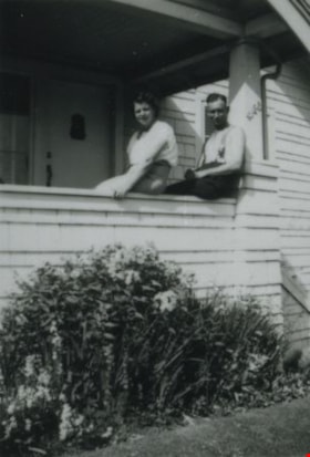
4123 Oxford Street
https://search.heritageburnaby.ca/link/archivedescription38197
- Repository
- City of Burnaby Archives
- Date
- 1953 (date of original), copied 1991
- Collection/Fonds
- Burnaby Historical Society fonds
- Description Level
- Item
- Physical Description
- 1 photograph : b&w ; 4.2 x 2.8 cm print on contact sheet 20.3 x 26.6 cm
- Scope and Content
- Photograph of a woman and a man sitting on the edge of the porch at 4123 Oxford Street.
- Repository
- City of Burnaby Archives
- Date
- 1953 (date of original), copied 1991
- Collection/Fonds
- Burnaby Historical Society fonds
- Subseries
- Burnaby Image Bank subseries
- Physical Description
- 1 photograph : b&w ; 4.2 x 2.8 cm print on contact sheet 20.3 x 26.6 cm
- Description Level
- Item
- Record No.
- 370-784
- Access Restriction
- No restrictions
- Reproduction Restriction
- No restrictions
- Accession Number
- BHS1999-03
- Scope and Content
- Photograph of a woman and a man sitting on the edge of the porch at 4123 Oxford Street.
- Media Type
- Photograph
- Notes
- Title based on contents of photograph
- 1 b&w copy negative accompanying
- Geographic Access
- Oxford Street
- Street Address
- 4123 Oxford Street
- Historic Neighbourhood
- Vancouver Heights (Historic Neighbourhood)
- Planning Study Area
- Burnaby Heights Area
Images

4200 Block Pandora Street
https://search.heritageburnaby.ca/link/archivedescription78914
- Repository
- City of Burnaby Archives
- Date
- September 5, 1976
- Collection/Fonds
- Burnaby Public Library Contemporary Visual Archive Project
- Description Level
- Item
- Physical Description
- 1 photograph : b&w ; 11 x 16 cm mounted on cardboard
- Scope and Content
- Photograph shows houses on 4200 Block Pandora Street, near Madison Avenue.
- Repository
- City of Burnaby Archives
- Date
- September 5, 1976
- Collection/Fonds
- Burnaby Public Library Contemporary Visual Archive Project
- Physical Description
- 1 photograph : b&w ; 11 x 16 cm mounted on cardboard
- Description Level
- Item
- Record No.
- 556-030
- Access Restriction
- No restrictions
- Reproduction Restriction
- Reproduce for fair dealing purposes only
- Accession Number
- 2013-13
- Scope and Content
- Photograph shows houses on 4200 Block Pandora Street, near Madison Avenue.
- Media Type
- Photograph
- Notes
- Scope note taken directly from BPL photograph description.
- 1 b&w copy negative : 10 x 12.5 cm accompanying
- Photographers identified by surnames only: Carr and Vardeman
- Geographic Access
- Pandora Street
- Historic Neighbourhood
- Vancouver Heights (Historic Neighbourhood)
- Planning Study Area
- Burnaby Heights Area
Images

4297 Albert Street
https://search.heritageburnaby.ca/link/archivedescription37591
- Repository
- City of Burnaby Archives
- Date
- 1951 (date of original), copied 1991
- Collection/Fonds
- Burnaby Historical Society fonds
- Description Level
- Item
- Physical Description
- 1 photograph : b&w ; 2.7 x 4.2 cm print on contact sheet 20.2 x 25.3 cm
- Scope and Content
- Photograph of 4297 Albert Street. Another house is visible in the background.
- Repository
- City of Burnaby Archives
- Date
- 1951 (date of original), copied 1991
- Collection/Fonds
- Burnaby Historical Society fonds
- Subseries
- Burnaby Image Bank subseries
- Physical Description
- 1 photograph : b&w ; 2.7 x 4.2 cm print on contact sheet 20.2 x 25.3 cm
- Description Level
- Item
- Record No.
- 370-179
- Access Restriction
- No restrictions
- Reproduction Restriction
- No restrictions
- Accession Number
- BHS1999-03
- Scope and Content
- Photograph of 4297 Albert Street. Another house is visible in the background.
- Subjects
- Buildings - Residential - Houses
- Media Type
- Photograph
- Notes
- Title based on contents of photograph
- 1 b&w copy negative accompanying
- Negative has a pink cast
- Geographic Access
- Albert Street
- Street Address
- 4297 Albert Street
- Historic Neighbourhood
- Vancouver Heights (Historic Neighbourhood)
- Planning Study Area
- Burnaby Heights Area
Images


4297 Albert Street
https://search.heritageburnaby.ca/link/archivedescription37592
- Repository
- City of Burnaby Archives
- Date
- 1950 (date of original), copied 1991
- Collection/Fonds
- Burnaby Historical Society fonds
- Description Level
- Item
- Physical Description
- 1 photograph : b&w ; 3.4 x 3.5 cm print on contact sheet 20.2 x 25.3 cm
- Scope and Content
- Photograph of 4297 Albert Street.
- Repository
- City of Burnaby Archives
- Date
- 1950 (date of original), copied 1991
- Collection/Fonds
- Burnaby Historical Society fonds
- Subseries
- Burnaby Image Bank subseries
- Physical Description
- 1 photograph : b&w ; 3.4 x 3.5 cm print on contact sheet 20.2 x 25.3 cm
- Description Level
- Item
- Record No.
- 370-180
- Access Restriction
- No restrictions
- Reproduction Restriction
- No restrictions
- Accession Number
- BHS1999-03
- Scope and Content
- Photograph of 4297 Albert Street.
- Subjects
- Buildings - Residential - Houses
- Media Type
- Photograph
- Notes
- Title based on contents of photograph
- 1 b&w copy negative accompanying
- Negative has a pink cast
- Geographic Access
- Albert Street
- Street Address
- 4297 Albert Street
- Historic Neighbourhood
- Vancouver Heights (Historic Neighbourhood)
- Planning Study Area
- Burnaby Heights Area
Images


4447 Venables Street
https://search.heritageburnaby.ca/link/archivedescription52397
- Repository
- City of Burnaby Archives
- Date
- 1975
- Collection/Fonds
- Harold H. Johnston fonds
- Description Level
- Item
- Physical Description
- 1 photograph (jpeg) : b&w
- Scope and Content
- Photograph of the Johnston family home at 4447 Venables Street. A woman (Frances Johnston) can be seen carrying parcels and walking towards the front steps of the home. A car is parked in front of the house.
- Repository
- City of Burnaby Archives
- Date
- 1975
- Collection/Fonds
- Harold H. Johnston fonds
- Physical Description
- 1 photograph (jpeg) : b&w
- Description Level
- Item
- Record No.
- 483-094
- Access Restriction
- No restrictions
- Reproduction Restriction
- No reproduction permitted
- Accession Number
- 2008-08
- Scope and Content
- Photograph of the Johnston family home at 4447 Venables Street. A woman (Frances Johnston) can be seen carrying parcels and walking towards the front steps of the home. A car is parked in front of the house.
- Subjects
- Buildings - Residential - Houses
- Names
- Johnston, Frances
- Media Type
- Photograph
- Photographer
- Johnston, Harold H.
- Notes
- Title based on contents of photograph
- Geographic Access
- Venables Street
- Street Address
- 4447 Venables Street
- Historic Neighbourhood
- Vancouver Heights (Historic Neighbourhood)
- Planning Study Area
- Willingdon Heights Area
Images

![4674 Southlawn Drive, [1958] (date of original), copied 1991 thumbnail](/media/hpo/_Data/_Archives_Images/_Unrestricted/370/370-461.jpg?width=280)
4674 Southlawn Drive
https://search.heritageburnaby.ca/link/archivedescription37873
- Repository
- City of Burnaby Archives
- Date
- [1958] (date of original), copied 1991
- Collection/Fonds
- Burnaby Historical Society fonds
- Description Level
- Item
- Physical Description
- 1 photograph : b&w ; 2.8 x 2.8 cm print on contact sheet 20.1 x 26.7 cm
- Scope and Content
- Photograph of 4674 Southlawn Drive in the snow. The snow-covered road can be seen in front of the house.
- Repository
- City of Burnaby Archives
- Date
- [1958] (date of original), copied 1991
- Collection/Fonds
- Burnaby Historical Society fonds
- Subseries
- Burnaby Image Bank subseries
- Physical Description
- 1 photograph : b&w ; 2.8 x 2.8 cm print on contact sheet 20.1 x 26.7 cm
- Description Level
- Item
- Record No.
- 370-461
- Access Restriction
- No restrictions
- Reproduction Restriction
- No restrictions
- Accession Number
- BHS1999-03
- Scope and Content
- Photograph of 4674 Southlawn Drive in the snow. The snow-covered road can be seen in front of the house.
- Media Type
- Photograph
- Notes
- Title based on contents of photograph
- 1 b&w copy negative accompanying
- Negative has a pink cast
- Geographic Access
- Southlawn Drive
- Street Address
- 4674 Southlawn Drive
- Planning Study Area
- Brentwood Area
Images
![4674 Southlawn Drive, [1958] (date of original), copied 1991 thumbnail](/media/hpo/_Data/_Archives_Images/_Unrestricted/370/370-461.jpg)
![4674 Southlawn Drive, [ca. 1954] (date of original), copied 1991 thumbnail](/media/hpo/_Data/_Archives_Images/_Unrestricted/370/370-462.jpg?width=280)
4674 Southlawn Drive
https://search.heritageburnaby.ca/link/archivedescription37874
- Repository
- City of Burnaby Archives
- Date
- [ca. 1954] (date of original), copied 1991
- Collection/Fonds
- Burnaby Historical Society fonds
- Description Level
- Item
- Physical Description
- 1 photograph : b&w ; 2.5 x 3.7 cm print on contact sheet 20.1 x 26.7 cm
- Scope and Content
- Photograph of the view from 4674 Southlawn Drive, facing north. A car and houses across the street can be seen. Capitol Hill is visible in the distance.
- Repository
- City of Burnaby Archives
- Date
- [ca. 1954] (date of original), copied 1991
- Collection/Fonds
- Burnaby Historical Society fonds
- Subseries
- Burnaby Image Bank subseries
- Physical Description
- 1 photograph : b&w ; 2.5 x 3.7 cm print on contact sheet 20.1 x 26.7 cm
- Description Level
- Item
- Record No.
- 370-462
- Access Restriction
- No restrictions
- Reproduction Restriction
- No restrictions
- Accession Number
- BHS1999-03
- Scope and Content
- Photograph of the view from 4674 Southlawn Drive, facing north. A car and houses across the street can be seen. Capitol Hill is visible in the distance.
- Media Type
- Photograph
- Notes
- Title based on contents of photograph
- 1 b&w copy negative accompanying
- Negative has a pink cast
- Geographic Access
- Southlawn Drive
- Planning Study Area
- Brentwood Area
Images
![4674 Southlawn Drive, [ca. 1954] (date of original), copied 1991 thumbnail](/media/hpo/_Data/_Archives_Images/_Unrestricted/370/370-462.jpg)
![4674 Southlawn Drive construction, [1954 or 1955] (date of original), copied 1991 thumbnail](/media/hpo/_Data/_Archives_Images/_Unrestricted/370/370-460.jpg?width=280)
4674 Southlawn Drive construction
https://search.heritageburnaby.ca/link/archivedescription37872
- Repository
- City of Burnaby Archives
- Date
- [1954 or 1955] (date of original), copied 1991
- Collection/Fonds
- Burnaby Historical Society fonds
- Description Level
- Item
- Physical Description
- 1 photograph : b&w ; 2.8 x 2.8 cm print on contact sheet 20.1 x 26.7 cm
- Scope and Content
- Photograph of the begining construction of a house at 4674 Southlawn Drive.
- Repository
- City of Burnaby Archives
- Date
- [1954 or 1955] (date of original), copied 1991
- Collection/Fonds
- Burnaby Historical Society fonds
- Subseries
- Burnaby Image Bank subseries
- Physical Description
- 1 photograph : b&w ; 2.8 x 2.8 cm print on contact sheet 20.1 x 26.7 cm
- Description Level
- Item
- Record No.
- 370-460
- Access Restriction
- No restrictions
- Reproduction Restriction
- No restrictions
- Accession Number
- BHS1999-03
- Scope and Content
- Photograph of the begining construction of a house at 4674 Southlawn Drive.
- Subjects
- Construction
- Media Type
- Photograph
- Notes
- Title based on contents of photograph
- 1 b&w copy negative accompanying
- Negative has a pink cast
- Geographic Access
- Southlawn Drive
- Street Address
- 4674 Southlawn Drive
- Planning Study Area
- Brentwood Area
Images
![4674 Southlawn Drive construction, [1954 or 1955] (date of original), copied 1991 thumbnail](/media/hpo/_Data/_Archives_Images/_Unrestricted/370/370-460.jpg)

4700 Block Kingsway
https://search.heritageburnaby.ca/link/archivedescription79227
- Repository
- City of Burnaby Archives
- Date
- February 7, 1977
- Collection/Fonds
- Burnaby Public Library Contemporary Visual Archive Project
- Description Level
- Item
- Physical Description
- 1 photograph : b&w ; 11 x 16 cm mounted on cardboard
- Scope and Content
- Photograph shows small businesses in the 4700 block Kingsway looking east along Kingsway. Businesses include William's Cafe, Fire Places Unlimited and Vacuum Self-Service.
- Repository
- City of Burnaby Archives
- Date
- February 7, 1977
- Collection/Fonds
- Burnaby Public Library Contemporary Visual Archive Project
- Physical Description
- 1 photograph : b&w ; 11 x 16 cm mounted on cardboard
- Description Level
- Item
- Record No.
- 556-210
- Access Restriction
- No restrictions
- Reproduction Restriction
- Reproduce for fair dealing purposes only
- Accession Number
- 2013-13
- Scope and Content
- Photograph shows small businesses in the 4700 block Kingsway looking east along Kingsway. Businesses include William's Cafe, Fire Places Unlimited and Vacuum Self-Service.
- Media Type
- Photograph
- Notes
- Scope note taken directly from BPL photograph description.
- 1 b&w copy negative : 10 x 12.5 cm accompanying
- Photographers identified by surnames only: Carr and Vardeman
- Geographic Access
- Kingsway
- Historic Neighbourhood
- Central Park (Historic Neighbourhood)
- Planning Study Area
- Marlborough Area
Images

![5486 Dominion Street, [between 1955 and 1959] (date of original), copied 2008 thumbnail](/media/hpo/_Data/_Archives_Images/_Unrestricted/600/620-048.jpg?width=280)
5486 Dominion Street
https://search.heritageburnaby.ca/link/archivedescription91867
- Repository
- City of Burnaby Archives
- Date
- [between 1955 and 1959] (date of original), copied 2008
- Collection/Fonds
- Small family fonds
- Description Level
- Item
- Physical Description
- 1 photograph : b&w copy print; 10 cm x 15 cm
- Scope and Content
- Photograph of a single-storey house with unpaved driveway located at 5486 Dominion Street. In 1954, John Roberts sold this lot to a builder who constructed the house and sold it.
- Repository
- City of Burnaby Archives
- Date
- [between 1955 and 1959] (date of original), copied 2008
- Collection/Fonds
- Small family fonds
- Physical Description
- 1 photograph : b&w copy print; 10 cm x 15 cm
- Description Level
- Item
- Record No.
- 620-048
- Access Restriction
- No restrictions
- Reproduction Restriction
- May be restricted by third party rights
- Accession Number
- 2017-01
- Scope and Content
- Photograph of a single-storey house with unpaved driveway located at 5486 Dominion Street. In 1954, John Roberts sold this lot to a builder who constructed the house and sold it.
- Subjects
- Buildings - Residential - Houses
- Media Type
- Photograph
- Notes
- Transcribed title
- Title transcribed from donor's notes
- Note in blue ink on verso of photograph reads: "P11"
- Note in blue ink on verso of photograph reads: "5486 Dominion St. / Probably late 1950s / Roberts' garage on left"
- 5486 Dominion Street later subdivided into two lots: 5480 and 5488 Dominion Street
- Street Address
- 5486 Dominion Street
- Historic Neighbourhood
- Burnaby Lake (Historic Neighbourhood)
- Planning Study Area
- Ardingley-Sprott Area
Images
![5486 Dominion Street, [between 1955 and 1959] (date of original), copied 2008 thumbnail](/media/hpo/_Data/_Archives_Images/_Unrestricted/600/620-048.jpg)