Narrow Results By
Decade
- 2020s 224
- 2010s 149
- 2000s 1822
- 1990s 2868
- 1980s 1364
- 1970s
- 1960s 1352
- 1950s 1670
- 1940s
- 1930s 2067
- 1920s 2345
- 1910s 1867
- 1900s 846
- 1890s 248
- 1880s 165
- 1870s 72
- 1860s 123
- 1850s 14
- 1840s 5
- 1830s 3
- 1820s 2
- 1810s 3
- 1800s 3
- 1790s 2
- 1780s 2
- 1770s 2
- 1760s 2
- 1750s 2
- 1740s 2
- 1730s 2
- 1720s 2
- 1710s 2
- 1700s 2
- 1690s 2
- 1680s 2
- 1670s 1
- 1660s 1
- 1650s 1
- 1640s 1
- 1630s 1
- 1620s 1
- 1610s 1
- 1600s 1
- 1590s 1
- 1580s 1
- 1570s 1
- 1560s 1
- 1550s 1
- 1540s 1
- 1530s 1
- 1520s 2
- 1510s 1
- 1500s 1
- 1490s 1
- 1480s 1
Subject
- Accidents 1
- Accidents - Automobile Accidents 3
- Accidents - Train Accidents 12
- Adminstrative Groups - Committees 4
- Adornment - Jewelry 1
- Advertising Medium 1
- Advertising Medium - Flyer 4
- Advertising Medium - Poster 15
- Advertising Medium - Signs and Signboards 83
- Aerial Photographs 53
- Agricultural Tools and Equipment 5
- Agricultural Tools and Equipment - Cultivators 2
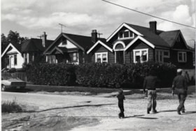
![3980 Albert Street, [between 1965 and 1970] thumbnail](/media/hpo/_Data/_Archives_Images/_Unrestricted/316/366-025.jpg?width=280)
3980 Albert Street
https://search.heritageburnaby.ca/link/archivedescription37396
- Repository
- City of Burnaby Archives
- Date
- [between 1965 and 1970]
- Collection/Fonds
- Burnaby Historical Society fonds
- Description Level
- Item
- Physical Description
- 1 photograph : b&w negative
- Scope and Content
- Photograph of a house located at 3980 Albert Street (old street number).
- Repository
- City of Burnaby Archives
- Date
- [between 1965 and 1970]
- Collection/Fonds
- Burnaby Historical Society fonds
- Subseries
- Municipal record subseries
- Physical Description
- 1 photograph : b&w negative
- Description Level
- Item
- Record No.
- 366-025
- Access Restriction
- No restrictions
- Reproduction Restriction
- Reproduce for fair dealing purposes only
- Accession Number
- BHS1998-12
- Scope and Content
- Photograph of a house located at 3980 Albert Street (old street number).
- Subjects
- Buildings - Residential - Houses
- Media Type
- Photograph
- Notes
- Title based on contents of photograph
- Geographic Access
- Albert Street
- Historic Neighbourhood
- Vancouver Heights (Historic Neighbourhood)
- Planning Study Area
- Burnaby Heights Area
Images
![3980 Albert Street, [between 1965 and 1970] thumbnail](/media/hpo/_Data/_Archives_Images/_Unrestricted/316/366-025.jpg)
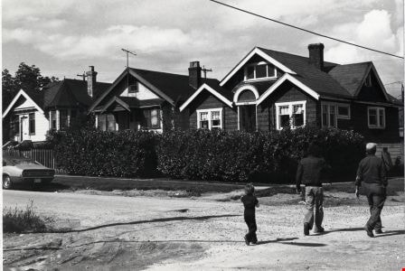
![4200 Block Cambridge Street, [1940] (date of original), copied 1991 thumbnail](/media/hpo/_Data/_Archives_Images/_Unrestricted/370/370-408.jpg?width=280)
4200 Block Cambridge Street
https://search.heritageburnaby.ca/link/archivedescription37820
- Repository
- City of Burnaby Archives
- Date
- [1940] (date of original), copied 1991
- Collection/Fonds
- Burnaby Historical Society fonds
- Description Level
- Item
- Physical Description
- 1 photograph : b&w ; 3.9 x 2.6 cm print on contact sheet 20.3 x 26.4 cm
- Scope and Content
- Photograph of a dog on the sidewalk of the 4200 block of Cambridge Street. The photograph was taken facing east, and Capitol Hill is visible in the background.
- Repository
- City of Burnaby Archives
- Date
- [1940] (date of original), copied 1991
- Collection/Fonds
- Burnaby Historical Society fonds
- Subseries
- Burnaby Image Bank subseries
- Physical Description
- 1 photograph : b&w ; 3.9 x 2.6 cm print on contact sheet 20.3 x 26.4 cm
- Description Level
- Item
- Record No.
- 370-408
- Access Restriction
- No restrictions
- Reproduction Restriction
- No known restrictions
- Accession Number
- BHS1999-03
- Scope and Content
- Photograph of a dog on the sidewalk of the 4200 block of Cambridge Street. The photograph was taken facing east, and Capitol Hill is visible in the background.
- Media Type
- Photograph
- Notes
- Title based on contents of photograph
- 1 b&w copy negative accompanying
- Negative has a pink cast
- Geographic Access
- Cambridge Street
- Historic Neighbourhood
- Vancouver Heights (Historic Neighbourhood)
- Planning Study Area
- Burnaby Heights Area
Images
![4200 Block Cambridge Street, [1940] (date of original), copied 1991 thumbnail](/media/hpo/_Data/_Archives_Images/_Unrestricted/370/370-408.jpg)
![4200 Block Cambridge Street, [1940] (date of original), copied 1991 thumbnail](/media/hpo/_Data/_Archives_Images/_Unrestricted/370/370-409.jpg?width=280)
4200 Block Cambridge Street
https://search.heritageburnaby.ca/link/archivedescription37821
- Repository
- City of Burnaby Archives
- Date
- [1940] (date of original), copied 1991
- Collection/Fonds
- Burnaby Historical Society fonds
- Description Level
- Item
- Physical Description
- 1 photograph : b&w ; 3.9 x 2.6 cm print on contact sheet 20.3 x 26.4 cm
- Scope and Content
- Photograph of a dog sitting beside the sidewalk on the 4200 block of Cambridge Street.
- Repository
- City of Burnaby Archives
- Date
- [1940] (date of original), copied 1991
- Collection/Fonds
- Burnaby Historical Society fonds
- Subseries
- Burnaby Image Bank subseries
- Physical Description
- 1 photograph : b&w ; 3.9 x 2.6 cm print on contact sheet 20.3 x 26.4 cm
- Description Level
- Item
- Record No.
- 370-409
- Access Restriction
- No restrictions
- Reproduction Restriction
- No known restrictions
- Accession Number
- BHS1999-03
- Scope and Content
- Photograph of a dog sitting beside the sidewalk on the 4200 block of Cambridge Street.
- Subjects
- Animals - Dogs
- Media Type
- Photograph
- Notes
- Title based on contents of photograph
- 1 b&w copy negative accompanying
- Negative has a pink cast
- Geographic Access
- Cambridge Street
- Historic Neighbourhood
- Vancouver Heights (Historic Neighbourhood)
- Planning Study Area
- Burnaby Heights Area
Images
![4200 Block Cambridge Street, [1940] (date of original), copied 1991 thumbnail](/media/hpo/_Data/_Archives_Images/_Unrestricted/370/370-409.jpg)
![4200 Block Cambridge Street, [ca. 1940] (date of original), copied 1991 thumbnail](/media/hpo/_Data/_Archives_Images/_Unrestricted/370/370-410.jpg?width=280)
4200 Block Cambridge Street
https://search.heritageburnaby.ca/link/archivedescription37822
- Repository
- City of Burnaby Archives
- Date
- [ca. 1940] (date of original), copied 1991
- Collection/Fonds
- Burnaby Historical Society fonds
- Description Level
- Item
- Physical Description
- 1 photograph : b&w ; 3.9 x 2.6 cm print on contact sheet 20.3 x 26.4 cm
- Scope and Content
- Photograph of a dog standing beside the sidewalk on the 4200 block of Cambridge Street. The back of a car can be seen on the right, and the road can be seen in the background.
- Repository
- City of Burnaby Archives
- Date
- [ca. 1940] (date of original), copied 1991
- Collection/Fonds
- Burnaby Historical Society fonds
- Subseries
- Burnaby Image Bank subseries
- Physical Description
- 1 photograph : b&w ; 3.9 x 2.6 cm print on contact sheet 20.3 x 26.4 cm
- Description Level
- Item
- Record No.
- 370-410
- Access Restriction
- No restrictions
- Reproduction Restriction
- No known restrictions
- Accession Number
- BHS1999-03
- Scope and Content
- Photograph of a dog standing beside the sidewalk on the 4200 block of Cambridge Street. The back of a car can be seen on the right, and the road can be seen in the background.
- Subjects
- Animals - Dogs
- Media Type
- Photograph
- Notes
- Title based on contents of photograph
- 1 b&w copy negative accompanying
- Negative has a pink cast
- Geographic Access
- Cambridge Street
- Historic Neighbourhood
- Vancouver Heights (Historic Neighbourhood)
- Planning Study Area
- Burnaby Heights Area
Images
![4200 Block Cambridge Street, [ca. 1940] (date of original), copied 1991 thumbnail](/media/hpo/_Data/_Archives_Images/_Unrestricted/370/370-410.jpg)
4200 Block Pandora Street
https://search.heritageburnaby.ca/link/archivedescription78914
- Repository
- City of Burnaby Archives
- Date
- September 5, 1976
- Collection/Fonds
- Burnaby Public Library Contemporary Visual Archive Project
- Description Level
- Item
- Physical Description
- 1 photograph : b&w ; 11 x 16 cm mounted on cardboard
- Scope and Content
- Photograph shows houses on 4200 Block Pandora Street, near Madison Avenue.
- Repository
- City of Burnaby Archives
- Date
- September 5, 1976
- Collection/Fonds
- Burnaby Public Library Contemporary Visual Archive Project
- Physical Description
- 1 photograph : b&w ; 11 x 16 cm mounted on cardboard
- Description Level
- Item
- Record No.
- 556-030
- Access Restriction
- No restrictions
- Reproduction Restriction
- Reproduce for fair dealing purposes only
- Accession Number
- 2013-13
- Scope and Content
- Photograph shows houses on 4200 Block Pandora Street, near Madison Avenue.
- Media Type
- Photograph
- Notes
- Scope note taken directly from BPL photograph description.
- 1 b&w copy negative : 10 x 12.5 cm accompanying
- Photographers identified by surnames only: Carr and Vardeman
- Geographic Access
- Pandora Street
- Historic Neighbourhood
- Vancouver Heights (Historic Neighbourhood)
- Planning Study Area
- Burnaby Heights Area
Images

4447 Venables Street
https://search.heritageburnaby.ca/link/archivedescription52397
- Repository
- City of Burnaby Archives
- Date
- 1975
- Collection/Fonds
- Harold H. Johnston fonds
- Description Level
- Item
- Physical Description
- 1 photograph (jpeg) : b&w
- Scope and Content
- Photograph of the Johnston family home at 4447 Venables Street. A woman (Frances Johnston) can be seen carrying parcels and walking towards the front steps of the home. A car is parked in front of the house.
- Repository
- City of Burnaby Archives
- Date
- 1975
- Collection/Fonds
- Harold H. Johnston fonds
- Physical Description
- 1 photograph (jpeg) : b&w
- Description Level
- Item
- Record No.
- 483-094
- Access Restriction
- No restrictions
- Reproduction Restriction
- No reproduction permitted
- Accession Number
- 2008-08
- Scope and Content
- Photograph of the Johnston family home at 4447 Venables Street. A woman (Frances Johnston) can be seen carrying parcels and walking towards the front steps of the home. A car is parked in front of the house.
- Subjects
- Buildings - Residential - Houses
- Names
- Johnston, Frances
- Media Type
- Photograph
- Photographer
- Johnston, Harold H.
- Notes
- Title based on contents of photograph
- Geographic Access
- Venables Street
- Street Address
- 4447 Venables Street
- Historic Neighbourhood
- Vancouver Heights (Historic Neighbourhood)
- Planning Study Area
- Willingdon Heights Area
Images


4700 Block Kingsway
https://search.heritageburnaby.ca/link/archivedescription79227
- Repository
- City of Burnaby Archives
- Date
- February 7, 1977
- Collection/Fonds
- Burnaby Public Library Contemporary Visual Archive Project
- Description Level
- Item
- Physical Description
- 1 photograph : b&w ; 11 x 16 cm mounted on cardboard
- Scope and Content
- Photograph shows small businesses in the 4700 block Kingsway looking east along Kingsway. Businesses include William's Cafe, Fire Places Unlimited and Vacuum Self-Service.
- Repository
- City of Burnaby Archives
- Date
- February 7, 1977
- Collection/Fonds
- Burnaby Public Library Contemporary Visual Archive Project
- Physical Description
- 1 photograph : b&w ; 11 x 16 cm mounted on cardboard
- Description Level
- Item
- Record No.
- 556-210
- Access Restriction
- No restrictions
- Reproduction Restriction
- Reproduce for fair dealing purposes only
- Accession Number
- 2013-13
- Scope and Content
- Photograph shows small businesses in the 4700 block Kingsway looking east along Kingsway. Businesses include William's Cafe, Fire Places Unlimited and Vacuum Self-Service.
- Media Type
- Photograph
- Notes
- Scope note taken directly from BPL photograph description.
- 1 b&w copy negative : 10 x 12.5 cm accompanying
- Photographers identified by surnames only: Carr and Vardeman
- Geographic Access
- Kingsway
- Historic Neighbourhood
- Central Park (Historic Neighbourhood)
- Planning Study Area
- Marlborough Area
Images

![5165 Sperling Avenue construction, [1941 or 1942] (date of original), copied 1991 thumbnail](/media/hpo/_Data/_Archives_Images/_Unrestricted/370/370-550.jpg?width=280)
5165 Sperling Avenue construction
https://search.heritageburnaby.ca/link/archivedescription37963
- Repository
- City of Burnaby Archives
- Date
- [1941 or 1942] (date of original), copied 1991
- Collection/Fonds
- Burnaby Historical Society fonds
- Description Level
- Item
- Physical Description
- 1 photograph : b&w ; 2.6 x 3.7 cm print on contact sheet 20.7 x 26.2 cm
- Scope and Content
- Photograph of the house of the Montague Moore family under construction at 5165 Sperling Avenue.
- Repository
- City of Burnaby Archives
- Date
- [1941 or 1942] (date of original), copied 1991
- Collection/Fonds
- Burnaby Historical Society fonds
- Subseries
- Burnaby Image Bank subseries
- Physical Description
- 1 photograph : b&w ; 2.6 x 3.7 cm print on contact sheet 20.7 x 26.2 cm
- Description Level
- Item
- Record No.
- 370-550
- Access Restriction
- No restrictions
- Reproduction Restriction
- No known restrictions
- Accession Number
- BHS1999-03
- Scope and Content
- Photograph of the house of the Montague Moore family under construction at 5165 Sperling Avenue.
- Media Type
- Photograph
- Notes
- Title based on contents of photograph
- 1 b&w copy negative accompanying
- Geographic Access
- Sperling Avenue
- Street Address
- 5165 Sperling Avenue
- Historic Neighbourhood
- Burnaby Lake (Historic Neighbourhood)
- Planning Study Area
- Morley-Buckingham Area
Images
![5165 Sperling Avenue construction, [1941 or 1942] (date of original), copied 1991 thumbnail](/media/hpo/_Data/_Archives_Images/_Unrestricted/370/370-550.jpg)
![5165 Sperling Avenue construction, [1941 or 1942] (date of original), copied 1991 thumbnail](/media/hpo/_Data/_Archives_Images/_Unrestricted/370/370-551.jpg?width=280)
5165 Sperling Avenue construction
https://search.heritageburnaby.ca/link/archivedescription37964
- Repository
- City of Burnaby Archives
- Date
- [1941 or 1942] (date of original), copied 1991
- Collection/Fonds
- Burnaby Historical Society fonds
- Description Level
- Item
- Physical Description
- 1 photograph : b&w ; 2.6 x 3.7 cm print on contact sheet 20.7 x 26.2 cm
- Scope and Content
- Photograph of the house of the Montague Moore family under construction at 5165 Sperling Avenue. Other houses on the street can be seen to the right, and the road can be seen in the foreground.
- Repository
- City of Burnaby Archives
- Date
- [1941 or 1942] (date of original), copied 1991
- Collection/Fonds
- Burnaby Historical Society fonds
- Subseries
- Burnaby Image Bank subseries
- Physical Description
- 1 photograph : b&w ; 2.6 x 3.7 cm print on contact sheet 20.7 x 26.2 cm
- Description Level
- Item
- Record No.
- 370-551
- Access Restriction
- No restrictions
- Reproduction Restriction
- No known restrictions
- Accession Number
- BHS1999-03
- Scope and Content
- Photograph of the house of the Montague Moore family under construction at 5165 Sperling Avenue. Other houses on the street can be seen to the right, and the road can be seen in the foreground.
- Media Type
- Photograph
- Notes
- Title based on contents of photograph
- 1 b&w copy negative accompanying
- Geographic Access
- Sperling Avenue
- Street Address
- 5165 Sperling Avenue
- Historic Neighbourhood
- Burnaby Lake (Historic Neighbourhood)
- Planning Study Area
- Morley-Buckingham Area
Images
![5165 Sperling Avenue construction, [1941 or 1942] (date of original), copied 1991 thumbnail](/media/hpo/_Data/_Archives_Images/_Unrestricted/370/370-551.jpg)

5486 Dominion Street
https://search.heritageburnaby.ca/link/archivedescription91871
- Repository
- City of Burnaby Archives
- Date
- 1971
- Collection/Fonds
- Small family fonds
- Description Level
- Item
- Physical Description
- 1 photograph : b&w ; 9 cm x 9 cm
- Scope and Content
- Photograph of the Small family's house at 5486 Dominion Street with a "For Sale" sign on the lawn. The house was put up for sale by Lauretta Small after she inherited the Roberts' house at 5538 Dominion Street in 1969. Lauretta, by then a widow, relocated back into the Roberts' house which was th…
- Repository
- City of Burnaby Archives
- Date
- 1971
- Collection/Fonds
- Small family fonds
- Physical Description
- 1 photograph : b&w ; 9 cm x 9 cm
- Description Level
- Item
- Record No.
- 620-052
- Access Restriction
- No restrictions
- Reproduction Restriction
- No reproduction permitted
- Accession Number
- 2017-01
- Scope and Content
- Photograph of the Small family's house at 5486 Dominion Street with a "For Sale" sign on the lawn. The house was put up for sale by Lauretta Small after she inherited the Roberts' house at 5538 Dominion Street in 1969. Lauretta, by then a widow, relocated back into the Roberts' house which was the house she grew up in as a child.
- Media Type
- Photograph
- Notes
- Transcribed title
- Title transcribed from donor's notes
- Note in blue ink on verso of photograph reads: "P.14"
- Note in blue ink on verso of photograph reads: "5486 Dominion St / Burnaby, B.C. / Fall '71"
- 5486 Dominion Street later subdivided into two lots: 5480 and 5488 Dominion Street
- Street Address
- 5486 Dominion Street
- Historic Neighbourhood
- Burnaby Lake (Historic Neighbourhood)
- Planning Study Area
- Ardingley-Sprott Area
Images

![5625 Georgia Street, [between 1975 and 1979] (date of original), copied 1991 thumbnail](/media/hpo/_Data/_Archives_Images/_Unrestricted/370/370-152.jpg?width=280)
5625 Georgia Street
https://search.heritageburnaby.ca/link/archivedescription37564
- Repository
- City of Burnaby Archives
- Date
- [between 1975 and 1979] (date of original), copied 1991
- Collection/Fonds
- Burnaby Historical Society fonds
- Description Level
- Item
- Physical Description
- 1 photograph : b&w ; 3.2 x 4.1 cm print on contact sheet 20.2 x 25.3 cm
- Scope and Content
- Photograph of the back of 5625 Georgia Street taken from 5676 Georgia Street.
- Repository
- City of Burnaby Archives
- Date
- [between 1975 and 1979] (date of original), copied 1991
- Collection/Fonds
- Burnaby Historical Society fonds
- Subseries
- Burnaby Image Bank subseries
- Physical Description
- 1 photograph : b&w ; 3.2 x 4.1 cm print on contact sheet 20.2 x 25.3 cm
- Description Level
- Item
- Record No.
- 370-152
- Access Restriction
- No restrictions
- Reproduction Restriction
- No restrictions
- Accession Number
- BHS1999-03
- Scope and Content
- Photograph of the back of 5625 Georgia Street taken from 5676 Georgia Street.
- Subjects
- Buildings - Residential - Houses
- Media Type
- Photograph
- Notes
- Title based on contents of photograph
- 1 b&w copy negative accompanying
- Copied from a col. photograph
- Geographic Access
- Georgia Street
- Street Address
- 5625 Georgia Street
- Historic Neighbourhood
- Capitol Hill (Historic Neighbourhood)
- Planning Study Area
- Parkcrest-Aubrey Area
Images
![5625 Georgia Street, [between 1975 and 1979] (date of original), copied 1991 thumbnail](/media/hpo/_Data/_Archives_Images/_Unrestricted/370/370-152.jpg)
![6100 Block Kathleen Avenue, [1943 or 1944] (date of original), copied 1991 thumbnail](/media/hpo/_Data/_Archives_Images/_Unrestricted/370/370-241.jpg?width=280)
6100 Block Kathleen Avenue
https://search.heritageburnaby.ca/link/archivedescription37653
- Repository
- City of Burnaby Archives
- Date
- [1943 or 1944] (date of original), copied 1991
- Collection/Fonds
- Burnaby Historical Society fonds
- Description Level
- Item
- Physical Description
- 1 photograph : b&w ; 3.1 x 4.5 cm print on contact sheet 20.2 x 25.3 cm
- Scope and Content
- Photograph taken looking north on Kathleen Avenue from the 6100 block of Kathleen Avenue after a snowfall.
- Repository
- City of Burnaby Archives
- Date
- [1943 or 1944] (date of original), copied 1991
- Collection/Fonds
- Burnaby Historical Society fonds
- Subseries
- Burnaby Image Bank subseries
- Physical Description
- 1 photograph : b&w ; 3.1 x 4.5 cm print on contact sheet 20.2 x 25.3 cm
- Description Level
- Item
- Record No.
- 370-241
- Access Restriction
- No restrictions
- Reproduction Restriction
- No known restrictions
- Accession Number
- BHS1999-03
- Scope and Content
- Photograph taken looking north on Kathleen Avenue from the 6100 block of Kathleen Avenue after a snowfall.
- Media Type
- Photograph
- Notes
- Title based on contents of photograph
- 1 b&w copy negative accompanying
- Negative has a pink cast
- Geographic Access
- Kathleen Avenue
- Historic Neighbourhood
- Central Park (Historic Neighbourhood)
- Planning Study Area
- Maywood Area
Images
![6100 Block Kathleen Avenue, [1943 or 1944] (date of original), copied 1991 thumbnail](/media/hpo/_Data/_Archives_Images/_Unrestricted/370/370-241.jpg)

6100 Block McMurray Avenue
https://search.heritageburnaby.ca/link/archivedescription78912
- Repository
- City of Burnaby Archives
- Date
- February 7, 1977
- Collection/Fonds
- Burnaby Public Library Contemporary Visual Archive Project
- Description Level
- Item
- Physical Description
- 1 photograph : b&w ; 11 x 16 cm mounted on cardboard
- Scope and Content
- Photograph shows houses on 6100 Block McMurray Avenue, near Grange Street.
- Repository
- City of Burnaby Archives
- Date
- February 7, 1977
- Collection/Fonds
- Burnaby Public Library Contemporary Visual Archive Project
- Physical Description
- 1 photograph : b&w ; 11 x 16 cm mounted on cardboard
- Description Level
- Item
- Record No.
- 556-029
- Access Restriction
- No restrictions
- Reproduction Restriction
- Reproduce for fair dealing purposes only
- Accession Number
- 2013-13
- Scope and Content
- Photograph shows houses on 6100 Block McMurray Avenue, near Grange Street.
- Media Type
- Photograph
- Notes
- Scope note taken directly from BPL photograph description.
- 1 b&w copy negative : 10 x 12.5 cm accompanying
- Photographers identified by surnames only: Carr and Vardeman
- Geographic Access
- McMurray Avenue
- Historic Neighbourhood
- Central Park (Historic Neighbourhood)
- Planning Study Area
- Marlborough Area
Images

![6113 Silver Avenue, [between 1945 and 1949] (date of original), copied 1991 thumbnail](/media/hpo/_Data/_Archives_Images/_Unrestricted/370/370-357.jpg?width=280)
6113 Silver Avenue
https://search.heritageburnaby.ca/link/archivedescription37769
- Repository
- City of Burnaby Archives
- Date
- [between 1945 and 1949] (date of original), copied 1991
- Collection/Fonds
- Burnaby Historical Society fonds
- Description Level
- Item
- Physical Description
- 1 photograph : b&w ; 2.7 x 3.9 cm print on contact sheet 20.3 x 26.2 cm
- Scope and Content
- Photograph of 6113 Silver Avenue, the Ellis family home, in the snow.
- Repository
- City of Burnaby Archives
- Date
- [between 1945 and 1949] (date of original), copied 1991
- Collection/Fonds
- Burnaby Historical Society fonds
- Subseries
- Burnaby Image Bank subseries
- Physical Description
- 1 photograph : b&w ; 2.7 x 3.9 cm print on contact sheet 20.3 x 26.2 cm
- Description Level
- Item
- Record No.
- 370-357
- Access Restriction
- No restrictions
- Reproduction Restriction
- No known restrictions
- Accession Number
- BHS1999-03
- Scope and Content
- Photograph of 6113 Silver Avenue, the Ellis family home, in the snow.
- Media Type
- Photograph
- Notes
- Title based on contents of photograph
- 1 b&w copy negative accompanying
- Negative has a pink cast
- Geographic Access
- Silver Avenue
- Street Address
- 6113 Silver Avenue
- Historic Neighbourhood
- Central Park (Historic Neighbourhood)
- Planning Study Area
- Maywood Area
Images
![6113 Silver Avenue, [between 1945 and 1949] (date of original), copied 1991 thumbnail](/media/hpo/_Data/_Archives_Images/_Unrestricted/370/370-357.jpg)
![6113 Silver Avenue, [1948 or 1949] (date of original), copied 1991 thumbnail](/media/hpo/_Data/_Archives_Images/_Unrestricted/370/370-369.jpg?width=280)
6113 Silver Avenue
https://search.heritageburnaby.ca/link/archivedescription37781
- Repository
- City of Burnaby Archives
- Date
- [1948 or 1949] (date of original), copied 1991
- Collection/Fonds
- Burnaby Historical Society fonds
- Description Level
- Item
- Physical Description
- 1 photograph : b&w ; 2.8 x 4.2 cm print on contact sheet 20.3 x 27.0 cm
- Scope and Content
- Photograph of fire damage at the side of 6113 Silver Avenue, the Ellis family home. A ladder is leaning against the side of the house, and a person can be seen in the window.
- Repository
- City of Burnaby Archives
- Date
- [1948 or 1949] (date of original), copied 1991
- Collection/Fonds
- Burnaby Historical Society fonds
- Subseries
- Burnaby Image Bank subseries
- Physical Description
- 1 photograph : b&w ; 2.8 x 4.2 cm print on contact sheet 20.3 x 27.0 cm
- Description Level
- Item
- Record No.
- 370-369
- Access Restriction
- No restrictions
- Reproduction Restriction
- No known restrictions
- Accession Number
- BHS1999-03
- Scope and Content
- Photograph of fire damage at the side of 6113 Silver Avenue, the Ellis family home. A ladder is leaning against the side of the house, and a person can be seen in the window.
- Subjects
- Buildings - Residential - Houses
- Media Type
- Photograph
- Notes
- Title based on contents of photograph
- 1 b&w copy negative accompanying
- Negative has a pink cast
- Geographic Access
- Silver Avenue
- Street Address
- 6113 Silver Avenue
- Historic Neighbourhood
- Central Park (Historic Neighbourhood)
- Planning Study Area
- Maywood Area
Images
![6113 Silver Avenue, [1948 or 1949] (date of original), copied 1991 thumbnail](/media/hpo/_Data/_Archives_Images/_Unrestricted/370/370-369.jpg)
![6113 Silver Avenue addition, [1947] (date of original), copied 1991 thumbnail](/media/hpo/_Data/_Archives_Images/_Unrestricted/370/370-367.jpg?width=280)
6113 Silver Avenue addition
https://search.heritageburnaby.ca/link/archivedescription37779
- Repository
- City of Burnaby Archives
- Date
- [1947] (date of original), copied 1991
- Collection/Fonds
- Burnaby Historical Society fonds
- Description Level
- Item
- Physical Description
- 1 photograph : b&w ; 2.5 x 3.6 cm print on contact sheet 20.3 x 26.2 cm
- Scope and Content
- Photograph of the construction of an addition to 6113 Silver Avenue, the Ellis family home. Three people are sitting on the roof of the house.
- Repository
- City of Burnaby Archives
- Date
- [1947] (date of original), copied 1991
- Collection/Fonds
- Burnaby Historical Society fonds
- Subseries
- Burnaby Image Bank subseries
- Physical Description
- 1 photograph : b&w ; 2.5 x 3.6 cm print on contact sheet 20.3 x 26.2 cm
- Description Level
- Item
- Record No.
- 370-367
- Access Restriction
- No restrictions
- Reproduction Restriction
- No known restrictions
- Accession Number
- BHS1999-03
- Scope and Content
- Photograph of the construction of an addition to 6113 Silver Avenue, the Ellis family home. Three people are sitting on the roof of the house.
- Media Type
- Photograph
- Notes
- Title based on contents of photograph
- 1 b&w copy negative accompanying
- Negative has a pink cast
- Geographic Access
- Silver Avenue
- Street Address
- 6113 Silver Avenue
- Historic Neighbourhood
- Central Park (Historic Neighbourhood)
- Planning Study Area
- Maywood Area
Images
![6113 Silver Avenue addition, [1947] (date of original), copied 1991 thumbnail](/media/hpo/_Data/_Archives_Images/_Unrestricted/370/370-367.jpg)
![6113 Silver Avenue addition, [1947] (date of original), copied 1991 thumbnail](/media/hpo/_Data/_Archives_Images/_Unrestricted/370/370-368.jpg?width=280)
6113 Silver Avenue addition
https://search.heritageburnaby.ca/link/archivedescription37780
- Repository
- City of Burnaby Archives
- Date
- [1947] (date of original), copied 1991
- Collection/Fonds
- Burnaby Historical Society fonds
- Description Level
- Item
- Physical Description
- 1 photograph : b&w ; 2.5 x 3.6 cm print on contact sheet 20.3 x 26.2 cm
- Scope and Content
- Photograpm of the completed construction of an addition to 6113 Silver Avenue, the Ellis family home. Another house and car can be seen to the left.
- Repository
- City of Burnaby Archives
- Date
- [1947] (date of original), copied 1991
- Collection/Fonds
- Burnaby Historical Society fonds
- Subseries
- Burnaby Image Bank subseries
- Physical Description
- 1 photograph : b&w ; 2.5 x 3.6 cm print on contact sheet 20.3 x 26.2 cm
- Description Level
- Item
- Record No.
- 370-368
- Access Restriction
- No restrictions
- Reproduction Restriction
- No known restrictions
- Accession Number
- BHS1999-03
- Scope and Content
- Photograpm of the completed construction of an addition to 6113 Silver Avenue, the Ellis family home. Another house and car can be seen to the left.
- Media Type
- Photograph
- Notes
- Title based on contents of photograph
- 1 b&w copy negative accompanying
- Negative has a pink cast
- Geographic Access
- Silver Avenue
- Street Address
- 6113 Silver Avenue
- Historic Neighbourhood
- Central Park (Historic Neighbourhood)
- Planning Study Area
- Maywood Area
Images
![6113 Silver Avenue addition, [1947] (date of original), copied 1991 thumbnail](/media/hpo/_Data/_Archives_Images/_Unrestricted/370/370-368.jpg)
![6595 Deer Lake Drive, [1948] (date of original), copied 1991 thumbnail](/media/hpo/_Data/_Archives_Images/_Unrestricted/370/370-565.jpg?width=280)
6595 Deer Lake Drive
https://search.heritageburnaby.ca/link/archivedescription37978
- Repository
- City of Burnaby Archives
- Date
- [1948] (date of original), copied 1991
- Collection/Fonds
- Burnaby Historical Society fonds
- Description Level
- Item
- Physical Description
- 1 photograph : b&w ; 2.7 x 4.8 cm print on contact sheet 20.7 x 26.2 cm
- Scope and Content
- Photograph of a house at 6595 Deer Lake Drive. Deer Lake can be seen in the background
- Repository
- City of Burnaby Archives
- Date
- [1948] (date of original), copied 1991
- Collection/Fonds
- Burnaby Historical Society fonds
- Subseries
- Burnaby Image Bank subseries
- Physical Description
- 1 photograph : b&w ; 2.7 x 4.8 cm print on contact sheet 20.7 x 26.2 cm
- Description Level
- Item
- Record No.
- 370-565
- Access Restriction
- No restrictions
- Reproduction Restriction
- No known restrictions
- Accession Number
- BHS1999-03
- Scope and Content
- Photograph of a house at 6595 Deer Lake Drive. Deer Lake can be seen in the background
- Subjects
- Buildings - Residential - Houses
- Media Type
- Photograph
- Notes
- Title based on contents of photograph
- 1 b&w copy negative accompanying
- Geographic Access
- Deer Lake
- Deer Lake Drive
- Street Address
- 6595 Deer Lake Drive
- Historic Neighbourhood
- Burnaby Lake (Historic Neighbourhood)
- Planning Study Area
- Morley-Buckingham Area
Images
![6595 Deer Lake Drive, [1948] (date of original), copied 1991 thumbnail](/media/hpo/_Data/_Archives_Images/_Unrestricted/370/370-565.jpg)
![6664 Deer Lake Avenue billiard room, [1979] thumbnail](/media/hpo/_Data/_Archives_Images/_Unrestricted/600/625-012.jpg?width=280)
6664 Deer Lake Avenue billiard room
https://search.heritageburnaby.ca/link/archivedescription95589
- Repository
- City of Burnaby Archives
- Date
- [1979]
- Collection/Fonds
- City of Burnaby Archives photograph collection
- Description Level
- File
- Physical Description
- 2 photographs (tiff)
- Scope and Content
- File contains photographs of the furnished billiard room in 6664 Deer Lake Avenue (formerly the F.J. Hart Estate "Avalon"; now Hart House). These photographs were taken prior to the City of Burnaby’s purchase of the home in 1979. The photographs depict the second floor room's fireplace, billiard ta…
- Repository
- City of Burnaby Archives
- Date
- [1979]
- Collection/Fonds
- City of Burnaby Archives photograph collection
- Physical Description
- 2 photographs (tiff)
- Description Level
- File
- Record No.
- 625-011
- Access Restriction
- No restrictions
- Reproduction Restriction
- Reproduce for fair dealing purposes only
- Accession Number
- 2021-10
- Scope and Content
- File contains photographs of the furnished billiard room in 6664 Deer Lake Avenue (formerly the F.J. Hart Estate "Avalon"; now Hart House). These photographs were taken prior to the City of Burnaby’s purchase of the home in 1979. The photographs depict the second floor room's fireplace, billiard table, and view to the southwest.
- Subjects
- Buildings - Heritage
- Media Type
- Photograph
- Notes
- Title based on caption
- Captions were added during digitization.
- Street Address
- 6664 Deer Lake Avenue
- Historic Neighbourhood
- Burnaby Lake (Historic Neighbourhood)
- Planning Study Area
- Morley-Buckingham Area
Images
![6664 Deer Lake Avenue billiard room, [1979] thumbnail](/media/hpo/_Data/_Archives_Images/_Unrestricted/600/625-012.jpg)
![6664 Deer Lake Avenue cabana, [1979] thumbnail](/media/hpo/_Data/_Archives_Images/_Unrestricted/600/625-018.jpg?width=280)
6664 Deer Lake Avenue cabana
https://search.heritageburnaby.ca/link/archivedescription95592
- Repository
- City of Burnaby Archives
- Date
- [1979]
- Collection/Fonds
- City of Burnaby Archives photograph collection
- Description Level
- File
- Physical Description
- 2 photographs (tiff)
- Scope and Content
- File contains photographs of the cabana in 6664 Deer Lake Avenue (formerly the F.J. Hart Estate "Avalon"; now Hart House). These photographs were taken prior to the City of Burnaby’s purchase of the home in 1979. The photographs depict the cabana's interior bar with an entrance to a changing room, …
- Repository
- City of Burnaby Archives
- Date
- [1979]
- Collection/Fonds
- City of Burnaby Archives photograph collection
- Physical Description
- 2 photographs (tiff)
- Description Level
- File
- Record No.
- 625-017
- Access Restriction
- No restrictions
- Reproduction Restriction
- Reproduce for fair dealing purposes only
- Accession Number
- 2021-10
- Scope and Content
- File contains photographs of the cabana in 6664 Deer Lake Avenue (formerly the F.J. Hart Estate "Avalon"; now Hart House). These photographs were taken prior to the City of Burnaby’s purchase of the home in 1979. The photographs depict the cabana's interior bar with an entrance to a changing room, and its view of the fish pond, swimming pool, and patio.
- Subjects
- Buildings - Heritage
- Media Type
- Photograph
- Notes
- Title based on caption
- Captions were added during digitization.
- Street Address
- 6664 Deer Lake Avenue
- Historic Neighbourhood
- Burnaby Lake (Historic Neighbourhood)
- Planning Study Area
- Morley-Buckingham Area
Images
![6664 Deer Lake Avenue cabana, [1979] thumbnail](/media/hpo/_Data/_Archives_Images/_Unrestricted/600/625-018.jpg)