Duncan & Margaret McGregor Estate 'Glen-Lyon' New Haven Barn
https://search.heritageburnaby.ca/link/landmark852
- Repository
- Burnaby Heritage Planning
- Description
- Designed in a vernacular architectural style, the New Haven Barn is a large gambrel-roofed barn located on the Edwardian era McGregor Estate 'Glen-Lyon,' overlooking the rich farmland of the Fraser River floodplain and near a ravine and forested area adjacent to Marine Drive in South Burnaby.
- Associated Dates
- 1939
- Formal Recognition
- Heritage Designation, Community Heritage Register
- Other Names
- Home of the Friendless, New Haven Borstal Home for Boys and Youthful Offenders, New Haven Correction Centre
- Street View URL
- Google Maps Street View
- Repository
- Burnaby Heritage Planning
- Other Names
- Home of the Friendless, New Haven Borstal Home for Boys and Youthful Offenders, New Haven Correction Centre
- Geographic Access
- Marine Drive
- Associated Dates
- 1939
- Formal Recognition
- Heritage Designation, Community Heritage Register
- Enactment Type
- Bylaw No. 12183
- Enactment Date
- 11/12/2006
- Description
- Designed in a vernacular architectural style, the New Haven Barn is a large gambrel-roofed barn located on the Edwardian era McGregor Estate 'Glen-Lyon,' overlooking the rich farmland of the Fraser River floodplain and near a ravine and forested area adjacent to Marine Drive in South Burnaby.
- Heritage Value
- The site is historically significant for its association with early social welfare and correctional reform. The estate was sold in 1926 to an inter-denominational religious organization called the Home of the Friendless, which used it as their B.C. headquarters. The organization was charged with several cases of abuse and neglect in 1937, after which a Royal Commission was formed that led to new legislation to regulate and license all private welfare institutions. 'Glen-Lyon' was sold to the provincial government, and was dedicated in 1939 by the Lt.-Gov. E.W. Hamber for use as the New Haven Borstal Home for Boys and Youthful Offenders (later renamed the New Haven Correction Centre). The Borstal movement originated in England in the late nineteenth century, as an alternative to sending young offenders and runaways to prisons by providing reformatories that focused on discipline and vocational skill. This site’s role as the first North American institution devoted to the Borstal School philosophy was historic, and influenced corrections programs across Canada. The New Haven Barn is a significant feature from its development in 1939 as the Borstal School, designed by Chief Provincial Architect Henry Whittaker of the Department of Public Works, and is the only remaining structure of its kind in Burnaby.
- Defining Elements
- Key elements that define the heritage character of the New Haven Barn include its: - gambrel-roofed barn with roof vent with finial, sliding hay loft and access doors, small multi-pane windows, and lapped wooden siding
- Historic Neighbourhood
- Fraser Arm (Historic Neighbourhood)
- Planning Study Area
- Big Bend Area
- Architect
- Henry Whittaker
- Function
- Primary Historic--Estate
- Community
- Burnaby
- Cadastral Identifier
- 003-004-661
- Boundaries
- 'Glen-Lyon' is comprised of a single residential lot located at 4250 Marine Drive, Burnaby.
- Area
- 230873.18
- Contributing Resource
- Building
- Ownership
- Private
- Names
- Whittaker, George
- New Haven Borstal Home for Boys and Youthful Offenders
- New Haven Correction Centre
- Borstal School
- Street Address
- 4250 Marine Drive
- Street View URL
- Google Maps Street View
Images


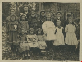
Dundonald School class
https://search.heritageburnaby.ca/link/museumdescription1368
- Repository
- Burnaby Village Museum
- Date
- 1906
- Collection/Fonds
- Burnaby Village Museum Photograph collection
- Description Level
- Item
- Physical Description
- 1 photograph : b&w ; 9 x 12 cm, mounted on card 18 x 23 cm
- Scope and Content
- Photograph of a class of eleven girls and two boys standing outside with their teacher Miss Annie Forrest at the Dundonald School. The students pictured in the photograph are; Maggie Byrne, Annie Thrussell, Nellie Woollard, Gussie Woollard, Elwood Bent and Tommy Brawnlie, Blanche Woollard, [first n…
- Repository
- Burnaby Village Museum
- Collection/Fonds
- Burnaby Village Museum Photograph collection
- Description Level
- Item
- Physical Description
- 1 photograph : b&w ; 9 x 12 cm, mounted on card 18 x 23 cm
- Scope and Content
- Photograph of a class of eleven girls and two boys standing outside with their teacher Miss Annie Forrest at the Dundonald School. The students pictured in the photograph are; Maggie Byrne, Annie Thrussell, Nellie Woollard, Gussie Woollard, Elwood Bent and Tommy Brawnlie, Blanche Woollard, [first name unknown] Brawnlie, Ethel Thrussell, Norah Byrne, Mary Byrne, Bessie Woollard and Alice Woollard. Later called Fraser Arm School, Dundonald School was the fourth school built in Burnaby.
- Subjects
- Occupations - Teachers
- Names
- Dundonald School
- Forrest, Annie Theresa
- Byrne, Margaret "Maggie"
- Thrussell, Annie
- Woollard, Nellie
- Woollard, Gussie
- Bent, Elwood
- Brawnlie, Tommy
- Woollard, Blanche
- Thrussell, Ethel
- Descoteau, Norah Irene Byrne
- Byrne, Mary
- Woollard, Bessie
- Woollard, Alice
- Geographic Access
- Marine Drive
- Street Address
- 5787 Marine Drive
- Accession Code
- BV999.2.58
- Access Restriction
- No restrictions
- Reproduction Restriction
- May be restricted by third party rights
- Date
- 1906
- Media Type
- Photograph
- Historic Neighbourhood
- Fraser Arm (Historic Neighbourhood)
- Planning Study Area
- Clinton-Glenwood Area
- Related Material
- For a copy print from BC archives of the same image, but cropped differently, see HV976.40.3
- Scan Resolution
- 600
- Scan Date
- 08-Jun-09
- Scale
- 100
- Notes
- Title based on contents of photograph
- Note on verso of photograph reads: "Dundonald School. 1906 Left to Right. Maggie Byrne, Annie Thrussell, Nellie Wollard, Gussie Woollard, Elwood Bent, Tommy Brawnlie, Blanche Woollard, Brawnlie, Ethel Thrussell, Nora Byrne, Mary Byrne Bessie Woollard, Alice Woollard."
- Note in pencil on recto of photograph reads: "1906"
Images


Eating your way through Burnaby: A look at Chinese Canadian history through food
https://search.heritageburnaby.ca/link/museumdescription14762
- Repository
- Burnaby Village Museum
- Date
- 27 Oct. 2020
- Collection/Fonds
- Burnaby Village Museum fonds
- Description Level
- Item
- Physical Description
- 1 video recording (mp4) (61 min., 56 sec.) : digital, col., sd., stereo ; 29 fps
- Scope and Content
- Item consists of a video recording of a live Zoom webinar hosted by Kate Petrusa, Burnaby Village Museum assistant curator. The webinar is titled "Eating your way through Burnaby: A look at Chinese Canadian history through food" and is presented by Denise Fong, Planning Assistant for the City of Bu…
- Repository
- Burnaby Village Museum
- Collection/Fonds
- Burnaby Village Museum fonds
- Description Level
- Item
- Physical Description
- 1 video recording (mp4) (61 min., 56 sec.) : digital, col., sd., stereo ; 29 fps
- Material Details
- Presenter: Denise Fong
- Host: Kate Petrusa
- Date of Presentation: October 27 7:00 pm - 8:00 pm
- Total Number of tracks: 1
- Total Length of all tracks:61 min., 56 sec.
- Recording Device: Zoom video communication platform
- Scope and Content
- Item consists of a video recording of a live Zoom webinar hosted by Kate Petrusa, Burnaby Village Museum assistant curator. The webinar is titled "Eating your way through Burnaby: A look at Chinese Canadian history through food" and is presented by Denise Fong, Planning Assistant for the City of Burnaby. The zoom webinar is the seventh in a collection of seven "Burnaby Neighbourhood Speaker series" webinars that were presented and made available to the public between September 29 and October 27, 2020. The live webinar and recording was also made available on the Burnaby Village Museum's facebook page. In this webinar, Denise Fong talks about how Chinese Canadians have played a key role in supplying food to Burnaby’s community through their participation in the local market gardening, green grocer, and restaurant industries. The presentation is supported with historical maps, photographs, documents, census records and stories from recent research on the 1960s-1970s period in Burnaby’s Big Bend and Capitol Hill neighborhoods. In her presentation, Denise also talks about the history of Chinese Immigration in Canada including the political circumstances and legal barriers that Chinese migrants faced in the late nineteenth to early twentieth century. Denise highlights specific Chinese Canadian family farms in Burnaby including; the Jung family farm located on 5460 Douglas Road operated by Jung Chong and his wife Jung Gee Shee; "Hop On Farms" located on Marine Drive, operated by Chan Kow Hong, Sui Ha Hong and family; the Tong Yip Farm located on Byrne Road operated by D.T. "George" Yip and his wife, Yip Chow Won Tai. Denise also highlights her recent research regarding Chinese Canadian corner stores and green grocers in Burnaby including; The Lee Kee grocery store located at 3824 East Hastings Street, owned and operated by Yow Lee Ko and his wife Say Jan Chan; the Burnaby Market located at 3942 East Hastings Street, owned and operated by Chin Yin Wong; the Quon Bros. located at 3702 East Hastings Street.; Y. Hoy Produce Co. located at 4092 East Hastings Street operated by Hoy Yen; Louie's Food Basket located at 5886 South East Marine Drive operated by Hoy Bew Louie, his wife Poy Yee and later by thier son Bing Louie and Tommy's Market located in Burnaby's Edmonds neighbourhood, operated by Tommy Chu. Denise also provides a detailed history of Tommy Chu and family who owned and operated Tommy's Market. Denise tells of how in the early 1970s, Chinese grocers in the lower mainland came together and formed the Lower Mainland Independent Grocers Association and Lower Mainland Grocers Co-Op. The organization was formed to protect the rights and promote businesses of independent grocers. In closing, Denise explains how her research of Chinese Canadian history in Burnaby continues and by the end of the project, the information will be made accessible in the form of a publication.
- Creator
- Burnaby Village Museum
- Subjects
- Persons - Chinese Canadians
- Social Issues - Discrimination
- Agriculture - Farms
- Social Issues - Racism
- Buildings - Commercial - Grocery Stores
- Names
- Fong, Denise
- Jung, Chung Chong
- Tommy's Produce
- Lee Kee Grocery
- Louie's Food Basket
- Louie, Hoy Bew
- Jung, Gee Shee
- Hong, Chan Kow
- Hong, Sui Ha
- Yip, D.T. "George"
- Yip, Chow Won Tai
- Ko, Yow Lee
- Ko, Chan Say Jan
- Burnaby Market
- Wong, Chin Yin
- Quon Bros.
- Y. Hoy Produce Co.
- Yen, Hoy
- Louie, Poy Yee
- Louie, Bing
- Chu, Tommy
- Chu, Sharon
- Chu, Calvin
- Responsibility
- Petrusa, Kate
- Geographic Access
- Hastings Street
- Accession Code
- BV020.29.7
- Access Restriction
- No restrictions
- Reproduction Restriction
- No known restrictions
- Date
- 27 Oct. 2020
- Media Type
- Moving Images
- Historic Neighbourhood
- Fraser Arm (Historic Neighbourhood)
- Vancouver Heights (Historic Neighbourhood)
- Planning Study Area
- Big Bend Area
- Burnaby Heights Area
- Notes
- Title based on contents of video recording
- Video recording was edited for publication on Heritage Burnaby. Original mp4 video recording (BV020.29.7.1) is 72 min., 14 sec.
Images

Video
Eating your way through Burnaby: A look at Chinese Canadian history through food, 27 Oct. 2020
Eating your way through Burnaby: A look at Chinese Canadian history through food, 27 Oct. 2020
https://search.heritageburnaby.ca/media/hpo/_Data/_BVM_Moving_Images/2020_0029_0007_002.mp4
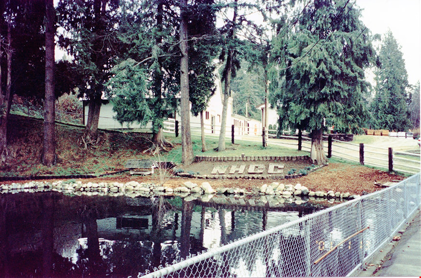
Entrance to New Haven
https://search.heritageburnaby.ca/link/museumdescription13532
- Repository
- Burnaby Village Museum
- Date
- Jan. 2001
- Collection/Fonds
- Burnaby Village Museum Photograph collection
- Description Level
- Item
- Physical Description
- 1 photograph : col. ; 5.3 x 10 cm
- Scope and Content
- Photograph of roadway entrance to New Haven Correctional Centre with the intitals "NHCC" located in a garden along the bank of a pond. Farm buildings are visible behind the trees.
- Repository
- Burnaby Village Museum
- Collection/Fonds
- Burnaby Village Museum Photograph collection
- Description Level
- Item
- Physical Description
- 1 photograph : col. ; 5.3 x 10 cm
- Scope and Content
- Photograph of roadway entrance to New Haven Correctional Centre with the intitals "NHCC" located in a garden along the bank of a pond. Farm buildings are visible behind the trees.
- History
- In 1937 New Haven Correctional Centre was established as the British Columbia Training School on the southeast side of Marine Drive in Burnaby (4250 Marine Drive). Sections of Sussex and Patterson Avenues bordered the estate. Originally, the facility housed nineteen inmates with two staff and was one of the first initiatives in Canada to segregate young adult inmates into a separate institution apart from adults. This was part of the Borstal system that started in England whereby young male offenders between the ages of sixteen and twenty one were trained to earn an honest living. Alterations and additions to the estate took place between December 1937 and October 1939 so that more inmates could be accomodated. Five new cottages were built that could hold up to forty people. Except for the plastering and lighting, all work on the new cottages was done by the inmates. On October 29, 1939, the Lieutenant-Governor Eric Hamber formally opened the New Haven Borstal School. World War II interrupted full development of the intstitution and it was closed in 1941 when the inmates were were conscripted into the army. Between 1941 and 1947 the Deaf and Blind Institute were housed at New Haven. In 1947, the New Haven Borstal School returned to the estate. New additions were added to old buildings and new additional buildings were erected on the site over the years including a warden's house on the east grounds and a barn and gymnasium. In the 1970s an equipment shed was added along with another dormitory and a variety of small sheds and storage buildings. The correctional centre officially closed in March 2001.
- Subjects
- Public Services - Correctional
- Geographic Access
- Marine Drive
- Street Address
- 4250 Marine Drive
- Accession Code
- BV020.5.876
- Access Restriction
- No restrictions
- Reproduction Restriction
- No known restrictions
- Date
- Jan. 2001
- Media Type
- Photograph
- Historic Neighbourhood
- Fraser Arm (Historic Neighbourhood)
- Planning Study Area
- Suncrest Area
- Scan Resolution
- 600
- Scan Date
- 25-Aug-2020
- Scale
- 100
- Notes
- Title based on contents of photograph
- Photograph processing stamp on front of photograph reads: "'01_1_13"
- Historical information based on notes from Mary Forsyth's research notes "New Haven" MSS185-018
Images
![Environment Week at Terminus Park, [1999] thumbnail](/media/hpo/_Data/_Archives_Images/_Unrestricted/535/535-3201.jpg?width=280)
Environment Week at Terminus Park
https://search.heritageburnaby.ca/link/archivedescription98122
- Repository
- City of Burnaby Archives
- Date
- [1999]
- Collection/Fonds
- Burnaby NewsLeader photograph collection
- Description Level
- Item
- Physical Description
- 1 photograph (tiff) : col.
- Scope and Content
- Photograph of Clinton Elementary School students Felipe Castaneda and Corey Itterman pulling out purple loosestrife from around a pond in Terminus Park (Burnaby Fraser Foreshore Park), during Burnaby's Environment Week celebrations.
- Repository
- City of Burnaby Archives
- Date
- [1999]
- Collection/Fonds
- Burnaby NewsLeader photograph collection
- Physical Description
- 1 photograph (tiff) : col.
- Description Level
- Item
- Record No.
- 535-3201
- Access Restriction
- No restrictions
- Reproduction Restriction
- No restrictions
- Accession Number
- 2018-12
- Scope and Content
- Photograph of Clinton Elementary School students Felipe Castaneda and Corey Itterman pulling out purple loosestrife from around a pond in Terminus Park (Burnaby Fraser Foreshore Park), during Burnaby's Environment Week celebrations.
- Media Type
- Photograph
- Photographer
- Bartel, Mario
- Notes
- Title based on caption
- Collected by editorial for use in a June 1999 issue of the Burnaby NewsLeader
- Caption from metadata: "Felipe Castaneda, 12, and Corey Itterman, 12, team up to pull out purple loosestrife, from around the ponds at Terminus Park. They were part of a team of students from Clinton Elementary, and Douglas College, pulling weeds and planting new grasses and bushes at the fledgling park, as part of Burnaby's Environment Week celebrations."
- Geographic Access
- Burnaby Fraser Foreshore Park
- Historic Neighbourhood
- Fraser Arm (Historic Neighbourhood)
- Planning Study Area
- Big Bend Area
Images
![Environment Week at Terminus Park, [1999] thumbnail](/media/hpo/_Data/_Archives_Images/_Unrestricted/535/535-3201.jpg)
![Ethel Thrussell, [1914] thumbnail](/media/hpo/_Data/_Archives_Images/_Unrestricted/251/275-008.jpg?width=280)
Ethel Thrussell
https://search.heritageburnaby.ca/link/archivedescription36476
- Repository
- City of Burnaby Archives
- Date
- [1914]
- Collection/Fonds
- Burnaby Historical Society fonds
- Description Level
- Item
- Physical Description
- 1 photograph : b&w ; 8.5 x 12.5 cm print
- Scope and Content
- Photograph of Ethel Thrussell, one of Frederick and Harriett Fenwick Thrussell's children, at the gate of the Thrussell family home.
- Repository
- City of Burnaby Archives
- Date
- [1914]
- Collection/Fonds
- Burnaby Historical Society fonds
- Subseries
- Thrussell family subseries
- Physical Description
- 1 photograph : b&w ; 8.5 x 12.5 cm print
- Description Level
- Item
- Record No.
- 275-008
- Access Restriction
- No restrictions
- Reproduction Restriction
- No known restrictions
- Accession Number
- BHS1992-05
- Scope and Content
- Photograph of Ethel Thrussell, one of Frederick and Harriett Fenwick Thrussell's children, at the gate of the Thrussell family home.
- Subjects
- Structures - Fences
- Names
- Thrussell, Ethel
- Media Type
- Photograph
- Notes
- Title based on contents of photograph
- Geographic Access
- Marine Drive
- Nelson Avenue
- Historic Neighbourhood
- Fraser Arm (Historic Neighbourhood)
- Planning Study Area
- Big Bend Area
Images
![Ethel Thrussell, [1914] thumbnail](/media/hpo/_Data/_Archives_Images/_Unrestricted/251/275-008.jpg)
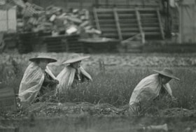
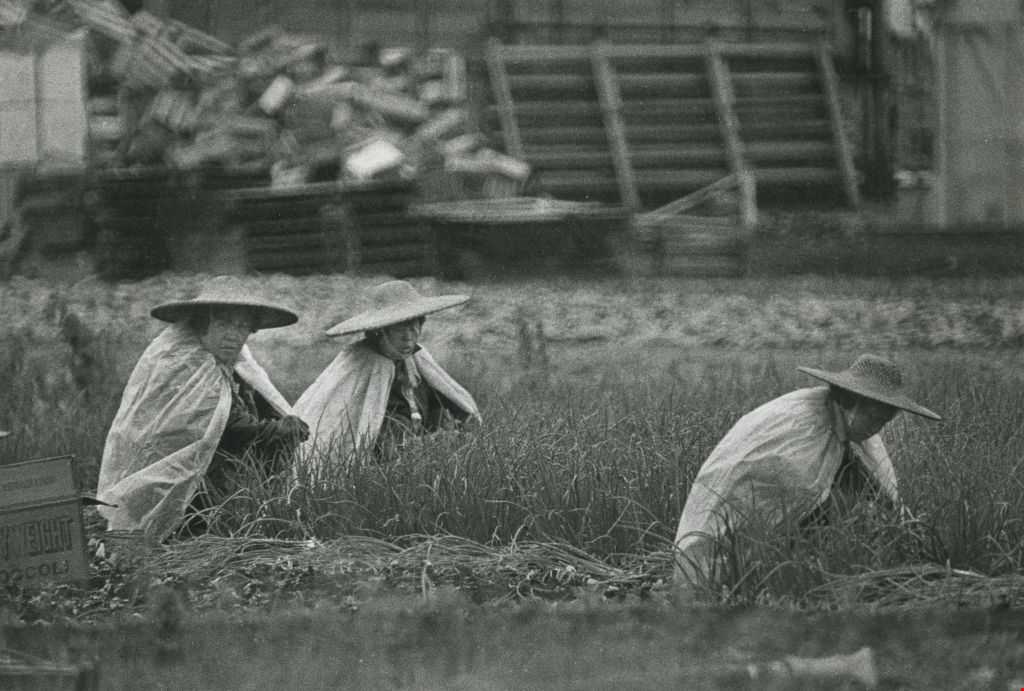
Farming in the rain
https://search.heritageburnaby.ca/link/archivedescription45325
- Repository
- City of Burnaby Archives
- Date
- July 13, 1981
- Collection/Fonds
- Columbian Newspaper collection
- Description Level
- Item
- Physical Description
- 1 photograph : b&w ; 15.5 x 22.5 cm
- Scope and Content
- Photograph of three farmers wearing straw hats and plastic shawls working in the rain in an onion field on the Burnaby flats near Meadow Street (now named Meadow Avenue).
- Repository
- City of Burnaby Archives
- Date
- July 13, 1981
- Collection/Fonds
- Columbian Newspaper collection
- Physical Description
- 1 photograph : b&w ; 15.5 x 22.5 cm
- Description Level
- Item
- Record No.
- 480-220
- Access Restriction
- No restrictions
- Reproduction Restriction
- No restrictions
- Accession Number
- 2003-02
- Scope and Content
- Photograph of three farmers wearing straw hats and plastic shawls working in the rain in an onion field on the Burnaby flats near Meadow Street (now named Meadow Avenue).
- Subjects
- Occupations - Farmers
- Media Type
- Photograph
- Photographer
- Battistoni, Peter
- Notes
- Title based on contents of photograph
- Newspaper clipping on verso of photograph reads: "WET WORK... Plastic sheets and broad straw hats protect field workers from the cool, wet elements at a farm on the Burnaby flats near Meadow Street this week. More seasonal weather, however, including rising temperatures and clearly [sic] skies, promises that life in the onion fields will be more tolerable, at least for the next little while."
- Geographic Access
- Meadow Avenue
- Historic Neighbourhood
- Fraser Arm (Historic Neighbourhood)
- Planning Study Area
- Big Bend Area
Images
![Finn Donnelly at the Swim for Salmon, [1999] thumbnail](/media/hpo/_Data/_Archives_Images/_Unrestricted/535/535-3346-1.jpg?width=280)
Finn Donnelly at the Swim for Salmon
https://search.heritageburnaby.ca/link/archivedescription98322
- Repository
- City of Burnaby Archives
- Date
- [1999]
- Collection/Fonds
- Burnaby NewsLeader photograph collection
- Description Level
- File
- Physical Description
- 2 photographs (tiff) : col.
- Scope and Content
- File contains photographs of marathon swimmer Finn Donnelly at Fraser Foreshore Park after completing the second leg of the Swim for Salmon event as part of BC Rivers Day. Photographs depict Donnelly posing on the shore and helping unidentified members of his crew to move canoes out of the Fraser R…
- Repository
- City of Burnaby Archives
- Date
- [1999]
- Collection/Fonds
- Burnaby NewsLeader photograph collection
- Physical Description
- 2 photographs (tiff) : col.
- Description Level
- File
- Record No.
- 535-3346
- Access Restriction
- No restrictions
- Reproduction Restriction
- No restrictions
- Accession Number
- 2018-12
- Scope and Content
- File contains photographs of marathon swimmer Finn Donnelly at Fraser Foreshore Park after completing the second leg of the Swim for Salmon event as part of BC Rivers Day. Photographs depict Donnelly posing on the shore and helping unidentified members of his crew to move canoes out of the Fraser River.
- Media Type
- Photograph
- Photographer
- Bartel, Mario
- Notes
- Title based on caption
- Collected by editorial for use in a September 1999 issue of the Burnaby NewsLeader
- Caption from metadata for 535-3346-1: "Marathon swimmer Finn Donnelly emerges from the Fraser River at Foreshare Park, after completing the second leg of his Swim for the Salmon to mark BC Rivers Day."
- Caption from metadata for 535-3346-2: "Marathon swimmer Finn Donnelly helps bring ashore some of the voyageur canoes which accompanied him on the second leg of his Swim for the Salmon, on the Fraser River from New West Quay to Foreshore Park."
- Geographic Access
- Fraser River
- Burnaby Fraser Foreshore Park
- Historic Neighbourhood
- Fraser Arm (Historic Neighbourhood)
- Planning Study Area
- Big Bend Area
Images
![Finn Donnelly at the Swim for Salmon, [1999] thumbnail](/media/hpo/_Data/_Archives_Images/_Unrestricted/535/535-3346-1.jpg)

Fire insurance key plan - Greater Vancouver - Volume XIX - Municipality of Burnaby
https://search.heritageburnaby.ca/link/museumdescription17799
- Repository
- Burnaby Village Museum
- Date
- 1927
- Collection/Fonds
- Burnaby Village Museum Map collection
- Description Level
- Item
- Physical Description
- 1 plan on 1 sheet : col. lithographic print ; 64 x 54 cm
- Scope and Content
- Item consists of a one page fire insurance key plan titled "Greater Vancouver / Volume XIX / Municipality / of Burnaby / Key Plan" surveyed May 1927. Key plan from compilation, "Insurance Plans of Greater Vancouver Plan No. 11, Volumes 15 to 19 Burnaby".
- Repository
- Burnaby Village Museum
- Collection/Fonds
- Burnaby Village Museum Map collection
- Description Level
- Item
- Physical Description
- 1 plan on 1 sheet : col. lithographic print ; 64 x 54 cm
- Material Details
- Scale [1:6000]
- Scope and Content
- Item consists of a one page fire insurance key plan titled "Greater Vancouver / Volume XIX / Municipality / of Burnaby / Key Plan" surveyed May 1927. Key plan from compilation, "Insurance Plans of Greater Vancouver Plan No. 11, Volumes 15 to 19 Burnaby".
- Publisher
- Plan Department of Fire Branch of British Columbia Underwriters' Association
- Accession Code
- BV987.1.70
- Access Restriction
- No restrictions
- Reproduction Restriction
- May be restricted by third party rights
- Date
- 1927
- Media Type
- Cartographic Material
- Historic Neighbourhood
- Fraser Arm (Historic Neighbourhood)
- Planning Study Area
- Big Bend Area
- Scan Resolution
- 400
- Scan Date
- 2021-11-17
- Notes
- Title based on contents of item
- Scale 500 feet = 1 inch
- These plans were removed from a bound book with labels on cover page reading: "Plan No. 90 / THIS INSURANCE PLAN / of / Vancouver VOLUME "8" / IN THE PROPERTY OF THE / British Columbia Insurance Underwriter's Association / Vancouver B.C. / AND IS LOANED / MELVILLE F. THOMSON CO. .../ Date May 26th, 1934"; / "Plan No. 74 / THIS INSURANCE PLAN / OF / VANCOUVER VOLUME "9"" / Plan No. 11 / THIS INSURANCE PLAN / OF / BURNABY VOLUMES 15-19" / "THIS PLAN IS THE PROPERTY OF / THE / BRITISH LAW INSURANCE COMPANY / LIMITED"
- Does not include the corresponding key plan page or associated plans numbered 1901 to 1914
- Contact Burnaby Village Museum to view associated fire insurance plans
Zoomable Images

Fire insurance key plan - Greater Vancouver - Volume XIX - Municipality of Burnaby, 1927
Zoom into Image![Flower auction and florist's shop, [2003] thumbnail](/media/hpo/_Data/_Archives_Images/_Unrestricted/535/535-1826-1.jpg?width=280)
Flower auction and florist's shop
https://search.heritageburnaby.ca/link/archivedescription96126
- Repository
- City of Burnaby Archives
- Date
- [2003]
- Collection/Fonds
- Burnaby NewsLeader photograph collection
- Description Level
- File
- Physical Description
- 9 photographs (tiff) : col.
- Scope and Content
- File contains photographs of Lucy Lo, a florist at Metro Flowers, during the flower auction at United Flower Growers Co-op on Marine Way and in her shop. Photographs depict the flowers and plants in the warehouse, the bidding theatre and process, and Lo creating floral arrangements.
- Repository
- City of Burnaby Archives
- Date
- [2003]
- Collection/Fonds
- Burnaby NewsLeader photograph collection
- Physical Description
- 9 photographs (tiff) : col.
- Description Level
- File
- Record No.
- 535-1826
- Access Restriction
- No restrictions
- Reproduction Restriction
- No restrictions
- Accession Number
- 2018-12
- Scope and Content
- File contains photographs of Lucy Lo, a florist at Metro Flowers, during the flower auction at United Flower Growers Co-op on Marine Way and in her shop. Photographs depict the flowers and plants in the warehouse, the bidding theatre and process, and Lo creating floral arrangements.
- Media Type
- Photograph
- Photographer
- Bartel, Mario
- Notes
- Title based on caption
- Collected by editorial for use in a January 2003 issue of the Burnaby NewsLeader
- Caption from metadata for 535-1826-1: "Auction day starts early for Burnaby florist, Lucy Lo, as she examines the flowers and plants up for sale at the United Flower Growers Co-op, on Marine Way. That means a walk-around tour of the giant warehouse at 5:30 AM to decide what she'll bid on when the auction begins at six."
- Caption from metadata for 535-1826-2: "Lucy studies the lots in the giant bidding theatre. The flower auction is actually a "Dutch Auction," which means prices start high and go down, with buyers bidding in at the price they're prepared to pay. All the bidding is done by keypad, with transactions recorded and tracked by computer."
- Caption from metadata for 535-1826-3: "Lucy, and her seatmate, Harold Calton, a florist in Richmond, concentrate as they study prices for the day's flowers. The two will sometimes split a lot one of them has bought if it's too large for their own store."
- Caption from metadata for 535-1826-4: "Bids at the auction are placed by a keypad that allows buyers to key in the price they're paying and the quantity of lots they're buying. The transactions are recorded by computer and by the time the auction is over, the buyer's purchases are organized and waiting for pickup in the warehouse."
- Caption from metadata for 535-1826-5: "The auction over, Lucy checks her order in the warehouse."
- Caption from metadata for 535-1826-6: "Lucy wheels part of her day's purchases to her car. Her husband will pick up the rest in his van. The flowers and plants will be on sale in her two stores the same day."
- Caption from metadata for 535-1826-7: "Back in her shop in Metrotown, Lucy creates an arrangement."
- Caption from metadata for 535-1826-8 and 535-1826-9: "Lucy examines a delicate orchid, in her shop, Metro Flowers."
- Geographic Access
- Marine Way
- Kingsway
- Historic Neighbourhood
- Fraser Arm (Historic Neighbourhood)
- Central Park (Historic Neighbourhood)
- Planning Study Area
- Big Bend Area
- Maywood Area
Images
![Flower auction and florist's shop, [2003] thumbnail](/media/hpo/_Data/_Archives_Images/_Unrestricted/535/535-1826-1.jpg)
![Foggy golf course, [2001] thumbnail](/media/hpo/_Data/_Archives_Images/_Unrestricted/535/535-1583.jpg?width=280)
Foggy golf course
https://search.heritageburnaby.ca/link/archivedescription95725
- Repository
- City of Burnaby Archives
- Date
- [2001]
- Collection/Fonds
- Burnaby NewsLeader photograph collection
- Description Level
- Item
- Physical Description
- 1 photograph (tiff) : col.
- Scope and Content
- Photograph of two golfers standing with their caddies on a golf course. They are surrounded by fog at the Riverway Golf Club.
- Repository
- City of Burnaby Archives
- Date
- [2001]
- Collection/Fonds
- Burnaby NewsLeader photograph collection
- Physical Description
- 1 photograph (tiff) : col.
- Description Level
- Item
- Record No.
- 535-1583
- Access Restriction
- No restrictions
- Reproduction Restriction
- No restrictions
- Accession Number
- 2018-12
- Scope and Content
- Photograph of two golfers standing with their caddies on a golf course. They are surrounded by fog at the Riverway Golf Club.
- Subjects
- Recreational Activities - Golf
- Names
- Riverway Golf Course
- Media Type
- Photograph
- Photographer
- Bartel, Mario
- Notes
- Title based on caption
- Collected by editorial for use in a January 2001 issue of the Burnaby NewsLeader
- Caption from metadata: "Golfers at Burnaby's Riverway Golf Club wait for the fog to lift so they can get in a round on Saturday. Heavy fog closed the course for two consecutive mornings."
- Geographic Access
- Bill Fox Way
- Street Address
- 9001 Bill Fox Way
- Historic Neighbourhood
- Fraser Arm (Historic Neighbourhood)
- Planning Study Area
- Big Bend Area
Images
![Foggy golf course, [2001] thumbnail](/media/hpo/_Data/_Archives_Images/_Unrestricted/535/535-1583.jpg)
![Four men standing on ʷməθkʷəy̓əm (Musqueam) First Nation farmland, [1951] (date of original), copied 2017 thumbnail](/media/hpo/_Data/_BVM_Images/2017/2017_0036_0005_001.jpg?width=280)
Four men standing on ʷməθkʷəy̓əm (Musqueam) First Nation farmland
https://search.heritageburnaby.ca/link/museumdescription4254
- Repository
- Burnaby Village Museum
- Date
- [1951] (date of original), copied 2017
- Collection/Fonds
- Burnaby Village Museum Photograph collection
- Description Level
- Item
- Physical Description
- 1 photograph (tiff) : 600 dpi
- Scope and Content
- Photograph of four men standing in farming clothing on leased farm land of the ʷməθkʷəy̓əm (Musqueam) First Nation. From L-R: Chan Kow Hong, Mr. Wong (Josephine Hong's uncle), Mr. Leong (Josephine Hong's uncle) and Gay Tim Hong. Planting crates evident on farmland in background.
- Repository
- Burnaby Village Museum
- Collection/Fonds
- Burnaby Village Museum Photograph collection
- Description Level
- Item
- Physical Description
- 1 photograph (tiff) : 600 dpi
- Scope and Content
- Photograph of four men standing in farming clothing on leased farm land of the ʷməθkʷəy̓əm (Musqueam) First Nation. From L-R: Chan Kow Hong, Mr. Wong (Josephine Hong's uncle), Mr. Leong (Josephine Hong's uncle) and Gay Tim Hong. Planting crates evident on farmland in background.
- History
- Josephine Hong was born to Sui Ha Hong and Chan Kow Hong. The Hong Family had seven children, oldest to youngest: Pauline, Josephine, Catherine, Norine, Gary, Darlene, and Marlene. The family runs Hop-On Farm on Marine Drive in Burnaby. Many Hong family members worked on the farm including Josephine Hong's grandfather, Gay Tim Hong, and uncles. Her great-grandfather was Sui Wing Hong.
- Geographic Access
- Byrne Road
- Accession Code
- BV017.36.5
- Access Restriction
- No restrictions
- Reproduction Restriction
- May be restricted by third party rights
- Date
- [1951] (date of original), copied 2017
- Media Type
- Photograph
- Historic Neighbourhood
- Fraser Arm (Historic Neighbourhood)
- Related Material
- See Oral History Interview-BV020.6.1
- Scan Resolution
- 600
- Scan Date
- 12/3/2017
- Scale
- 100
- Notes
- Title based on contents of photograph.
Images
![Four men standing on ʷməθkʷəy̓əm (Musqueam) First Nation farmland, [1951] (date of original), copied 2017 thumbnail](/media/hpo/_Data/_BVM_Images/2017/2017_0036_0005_001.jpg)
![Fraser Arm District, [between 1911 and 1919] thumbnail](/media/hpo/_Data/_Archives_Images/_Unrestricted/316/325-011.jpg?width=280)
Fraser Arm District
https://search.heritageburnaby.ca/link/archivedescription37139
- Repository
- City of Burnaby Archives
- Date
- [between 1911 and 1919]
- Collection/Fonds
- Burnaby Historical Society fonds
- Description Level
- Item
- Physical Description
- 1 photograph : b&w ; 8 x 12.5 cm print
- Scope and Content
- Photograph of the Fraser Arm District, taken from Marine Drive.
- Repository
- City of Burnaby Archives
- Date
- [between 1911 and 1919]
- Collection/Fonds
- Burnaby Historical Society fonds
- Subseries
- Disney family subseries
- Physical Description
- 1 photograph : b&w ; 8 x 12.5 cm print
- Description Level
- Item
- Record No.
- 325-011
- Access Restriction
- No restrictions
- Reproduction Restriction
- No known restrictions
- Accession Number
- BHS1996-04
- Scope and Content
- Photograph of the Fraser Arm District, taken from Marine Drive.
- Media Type
- Photograph
- Photographer
- Disney, John Harold "Jack"
- Notes
- Title based on contents of photograph
- Historic Neighbourhood
- Fraser Arm (Historic Neighbourhood)
- Planning Study Area
- Big Bend Area
Images
![Fraser Arm District, [between 1911 and 1919] thumbnail](/media/hpo/_Data/_Archives_Images/_Unrestricted/316/325-011.jpg)

Fraser Arm Neighbourhood
https://search.heritageburnaby.ca/link/landmark708
- Repository
- Burnaby Heritage Planning
- Associated Dates
- 1925-1954
- Heritage Value
- By the late 1920s, the Fraser Arm Neighbourhood in Burnaby was developing into an industrial and manufacturing district. In 1931, the Canadian National Railway built a bridge over the Fraser River from Burnaby to Lulu Island and advertised that over 30 industries were currently operating along the North Fraser. Along with industries, this district remained an important agricultural area for the Lower Mainland. Chinese market gardens continued to develop and thrive and in 1926, the Vancouver Sun estimated that that Chinese farms in the Lower Fraser Valley then supplied 90 per cent of all green vegetables consumed in the Vancouver market area.
- Historic Neighbourhood
- Fraser Arm (Historic Neighbourhood)
- Planning Study Area
- Big Bend Area
Images


Fraser Arm Neighbourhood
https://search.heritageburnaby.ca/link/landmark737
- Repository
- Burnaby Heritage Planning
- Repository
- Burnaby Heritage Planning
- Heritage Value
- Hugh MacRoberts, a farmer on Sea Island in Richmond, constructed a trail (which later became Marine Drive) to New Westminster in 1862 in order to bring his produce to market. The land along the Fraser River had been used as cranberry bogs and the fertile soil allowed opportunities for hay, root crops and other agricultural endeavours. The settlement grew around the River Road and by 1905 the Dundonald School opened, followed three years later by the Fraser Arm Post Office.
- Historic Neighbourhood
- Fraser Arm (Historic Neighbourhood)
- Planning Study Area
- Big Bend Area
Images

Fraser Arm Neighbourhood
https://search.heritageburnaby.ca/link/landmark767
- Repository
- Burnaby Heritage Planning
- Associated Dates
- 1905-1924
- Heritage Value
- Fraser Arm - so named because there the tram crossed Gilley Avenue, running down to the North Arm of the Fraser River - was served by the River Road [Marine Drive] which traversed the municipality of Burnaby, leading to both New Westminster and Vancouver. This area did not experience a real estate boom during the 1909-1913 as did many other Burnaby neighbourhoods - in fact, by 1912, only three homes had been built along Riverway as it remained a predominantly agricultural area.
- Historic Neighbourhood
- Fraser Arm (Historic Neighbourhood)
- Planning Study Area
- Big Bend Area
Images
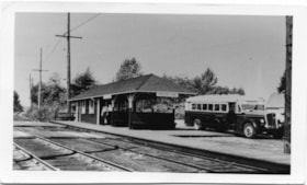
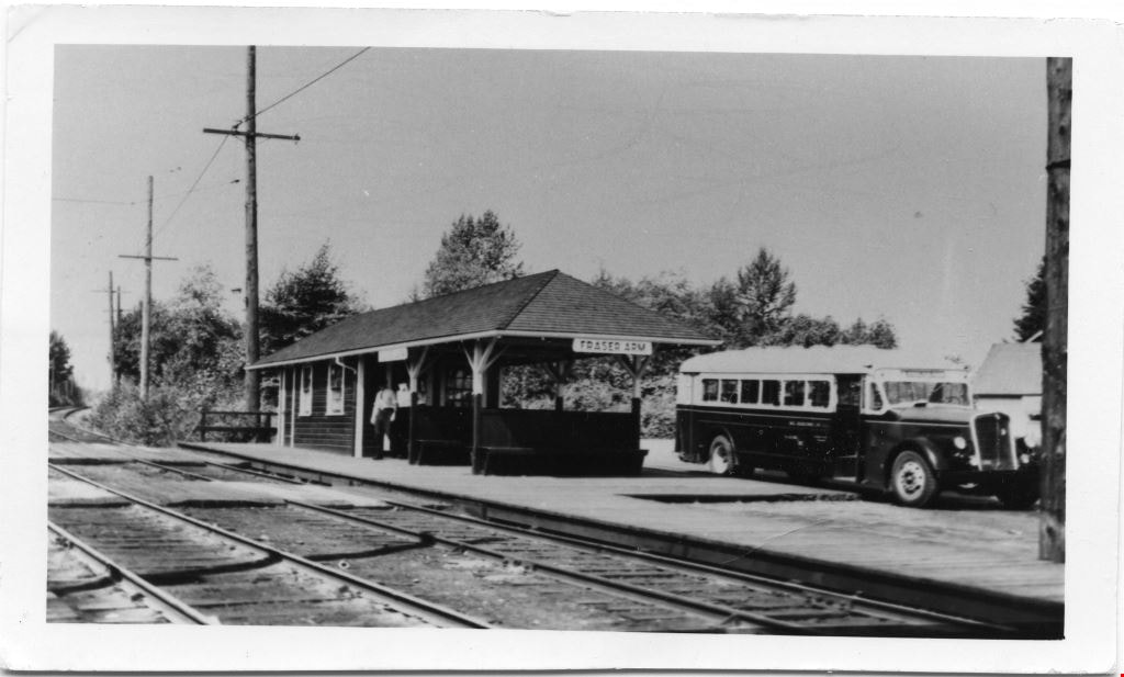
Fraser Arm rail and bus station
https://search.heritageburnaby.ca/link/museumdescription4782
- Repository
- Burnaby Village Museum
- Date
- 1930-1950
- Collection/Fonds
- Burnaby Village Museum Photograph collection
- Description Level
- Item
- Physical Description
- 1 photograph : b&w ; 6.7 x 11.4 cm ; copy print
- Scope and Content
- From left railtracks, power line, rail station shelter with man, station platform, bus facing right. Shelter has 'Fraser Arm' sign. Bus has 'BC Electric' lettered on side.
- Repository
- Burnaby Village Museum
- Collection/Fonds
- Burnaby Village Museum Photograph collection
- Description Level
- Item
- Physical Description
- 1 photograph : b&w ; 6.7 x 11.4 cm ; copy print
- Scope and Content
- From left railtracks, power line, rail station shelter with man, station platform, bus facing right. Shelter has 'Fraser Arm' sign. Bus has 'BC Electric' lettered on side.
- History
- Part of a set of photographs from the Columbian Newspaper, which operated out of New Westminster under this name starting in 1900 until its dissolution in 1988. Photographs found in the collection of the Burnaby Village are dated 1971.
- Other Title Information
- title based on content of photograph
- Accession Code
- BV018.19.8
- Access Restriction
- No restrictions
- Reproduction Restriction
- May be restricted by third party rights
- Date
- 1930-1950
- Media Type
- Photograph
- Historic Neighbourhood
- Fraser Arm (Historic Neighbourhood)
- Scan Resolution
- 600
- Scan Date
- 24-04-2018
Images
![Fraser River, [1930] thumbnail](/media/hpo/_Data/_Archives_Images/_Unrestricted/126/160-001.jpg?width=280)
Fraser River
https://search.heritageburnaby.ca/link/archivedescription34922
- Repository
- City of Burnaby Archives
- Date
- [1930]
- Collection/Fonds
- Burnaby Historical Society fonds
- Description Level
- Item
- Physical Description
- 1 photograph : b&w ; 28.3 x 18.6 cm
- Scope and Content
- Photograph of squatters' shacks and fishing boats on the shore of the Fraser River at the foot of Byrne Road. The photograph was taken from a boat on the north arm of the Fraser River.
- Repository
- City of Burnaby Archives
- Date
- [1930]
- Collection/Fonds
- Burnaby Historical Society fonds
- Subseries
- Bernard Bellinger subseries
- Physical Description
- 1 photograph : b&w ; 28.3 x 18.6 cm
- Description Level
- Item
- Record No.
- 160-001
- Access Restriction
- No restrictions
- Reproduction Restriction
- No known restrictions
- Accession Number
- BHS1986-10
- Scope and Content
- Photograph of squatters' shacks and fishing boats on the shore of the Fraser River at the foot of Byrne Road. The photograph was taken from a boat on the north arm of the Fraser River.
- Media Type
- Photograph
- Notes
- Title based on contents of photograph
- Geographic Access
- Byrne Road
- Historic Neighbourhood
- Fraser Arm (Historic Neighbourhood)
- Planning Study Area
- Big Bend Area
Images
![Fraser River, [1930] thumbnail](/media/hpo/_Data/_Archives_Images/_Unrestricted/126/160-001.jpg)
![Fraser River, [1930] (date of original), copied 1986 thumbnail](/media/hpo/_Data/_Archives_Images/_Unrestricted/126/160-002.jpg?width=280)
Fraser River
https://search.heritageburnaby.ca/link/archivedescription34923
- Repository
- City of Burnaby Archives
- Date
- [1930] (date of original), copied 1986
- Collection/Fonds
- Burnaby Historical Society fonds
- Description Level
- Item
- Physical Description
- 1 photograph : b&w ; 8.5 x 5.5 cm print
- Scope and Content
- Photograph of squatters' shacks on the shore of the Fraser River at the foot of Byrne Road.
- Repository
- City of Burnaby Archives
- Date
- [1930] (date of original), copied 1986
- Collection/Fonds
- Burnaby Historical Society fonds
- Subseries
- Bernard Bellinger subseries
- Physical Description
- 1 photograph : b&w ; 8.5 x 5.5 cm print
- Description Level
- Item
- Record No.
- 160-002
- Access Restriction
- No restrictions
- Reproduction Restriction
- No known restrictions
- Accession Number
- BHS1986-10
- Scope and Content
- Photograph of squatters' shacks on the shore of the Fraser River at the foot of Byrne Road.
- Media Type
- Photograph
- Notes
- Title based on contents of photograph
- Geographic Access
- Byrne Road
- Historic Neighbourhood
- Fraser Arm (Historic Neighbourhood)
- Planning Study Area
- Big Bend Area
Images
![Fraser River, [1930] (date of original), copied 1986 thumbnail](/media/hpo/_Data/_Archives_Images/_Unrestricted/126/160-002.jpg)
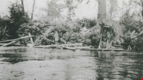
Fraser River
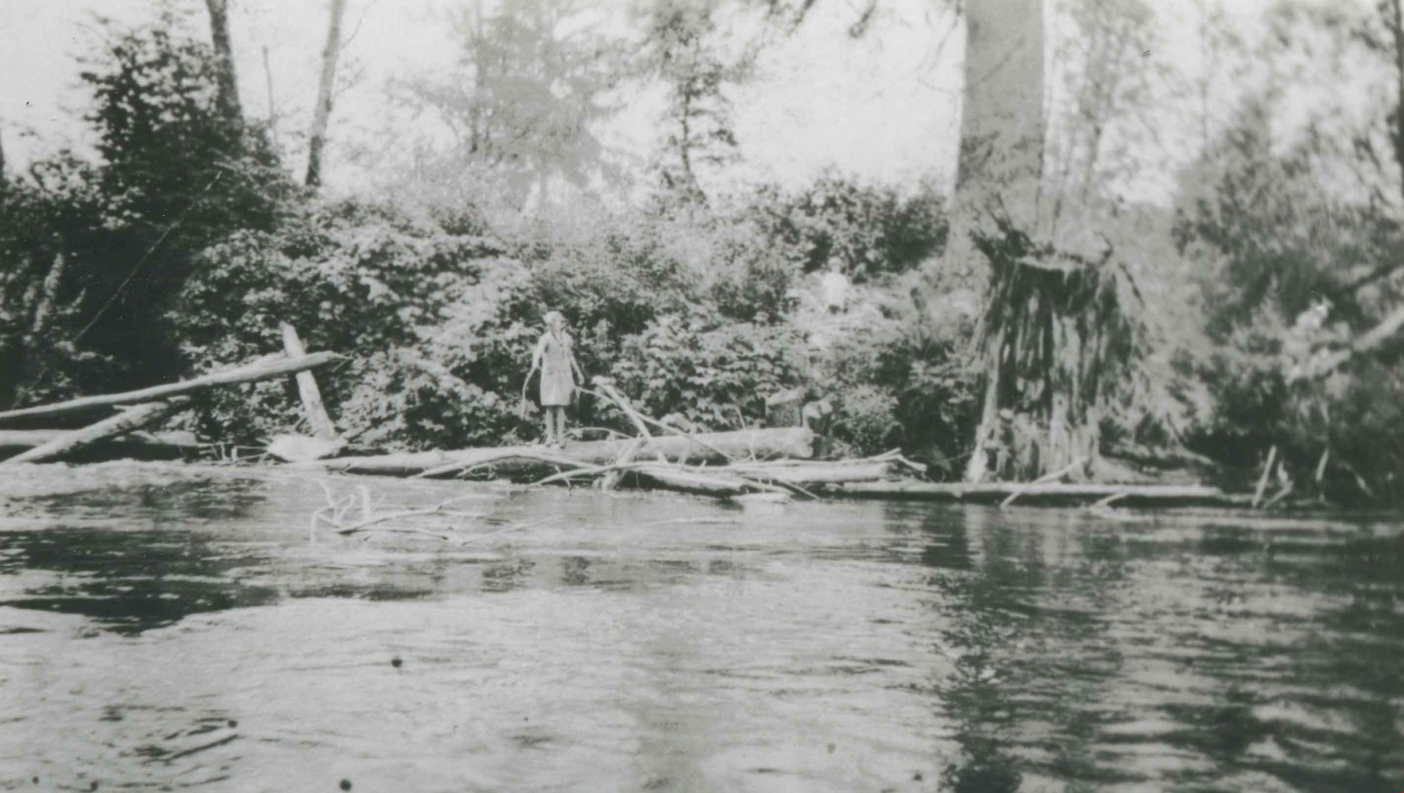
https://search.heritageburnaby.ca/link/archivedescription37077
- Repository
- City of Burnaby Archives
- Date
- 1920 (date of original), copied 1992
- Collection/Fonds
- Burnaby Historical Society fonds
- Description Level
- Item
- Physical Description
- 1 photograph : b&w ; 7.1 x 12.3 cm print
- Scope and Content
- Photograph of the Fraser River shore. A woman can be seen standing on a log on the river's edge.
- Repository
- City of Burnaby Archives
- Date
- 1920 (date of original), copied 1992
- Collection/Fonds
- Burnaby Historical Society fonds
- Subseries
- Burnaby Centennial Anthology subseries
- Physical Description
- 1 photograph : b&w ; 7.1 x 12.3 cm print
- Description Level
- Item
- Record No.
- 315-540
- Access Restriction
- No restrictions
- Reproduction Restriction
- No known restrictions
- Accession Number
- BHS1994-04
- Scope and Content
- Photograph of the Fraser River shore. A woman can be seen standing on a log on the river's edge.
- Subjects
- Geographic Features - Rivers
- Media Type
- Photograph
- Notes
- Title based on contents of photograph
- Historic Neighbourhood
- Fraser Arm (Historic Neighbourhood)
- Planning Study Area
- Big Bend Area
Images