Narrow Results By
Decade
- 2020s 217
- 2010s 144
- 2000s 1332
- 1990s 2707
- 1980s 1275
- 1970s 3376
- 1960s 1232
- 1950s 1541
- 1940s 1952
- 1930s 1997
- 1920s 2212
- 1910s 1718
- 1900s 758
- 1890s 220
- 1880s 158
- 1870s 70
- 1860s 118
- 1850s 13
- 1840s 5
- 1830s 2
- 1820s 2
- 1810s 3
- 1800s 3
- 1790s 2
- 1780s 2
- 1770s 2
- 1760s 2
- 1750s 2
- 1740s 2
- 1730s 2
- 1720s 2
- 1710s 2
- 1700s 2
- 1690s 2
- 1680s 2
- 1670s 1
- 1660s 1
- 1650s 1
- 1640s 1
- 1630s 1
- 1620s 1
- 1610s 1
- 1600s 1
- 1590s 1
- 1580s 1
- 1570s 1
- 1560s 1
- 1550s 1
- 1540s 1
- 1530s 1
- 1520s 2
- 1510s 1
- 1500s 1
- 1490s 1
- 1480s 1
Subject
- Accidents 11
- Accidents - Automobile Accidents 30
- Accidents - Train Accidents 23
- Adminstrative Groups - Committees 4
- Adornment - Jewelry 7
- Adornment - Lapel Pins 1
- Advertising Medium 10
- Advertising Medium - Flyer 4
- Advertising Medium - Poster 16
- Advertising Medium - Signs and Signboards 215
- Aerial Photographs 93
- Agricultural Tools and Equipment 22
![Edmonds Baptist Church Senior Boys Club, [192-] (date of original), copied 1986 thumbnail](/media/hpo/_Data/_Archives_Images/_Unrestricted/204/204-460.jpg?width=280)
Edmonds Baptist Church Senior Boys Club
https://search.heritageburnaby.ca/link/archivedescription35602
- Repository
- City of Burnaby Archives
- Date
- [192-] (date of original), copied 1986
- Collection/Fonds
- Burnaby Historical Society fonds
- Description Level
- Item
- Physical Description
- 1 photograph : b&w ; 12.7 x 17.8 cm print
- Scope and Content
- Photograph of the Edmonds Baptist Church senior boys club on a nature hike. Standing, left to right: Alex Bodley, Bill Astin, Bill Stickle, Arthur Thomson, Cecil Craig, and Joe Harris. Front, left to right: Norman Thomson and Walter Harris. Arthur Thomson was the group leader. Arthur Thomson a…
- Repository
- City of Burnaby Archives
- Date
- [192-] (date of original), copied 1986
- Collection/Fonds
- Burnaby Historical Society fonds
- Subseries
- Pioneer Tales subseries
- Physical Description
- 1 photograph : b&w ; 12.7 x 17.8 cm print
- Description Level
- Item
- Record No.
- 204-460
- Access Restriction
- No restrictions
- Reproduction Restriction
- No known restrictions
- Accession Number
- BHS1988-03
- Scope and Content
- Photograph of the Edmonds Baptist Church senior boys club on a nature hike. Standing, left to right: Alex Bodley, Bill Astin, Bill Stickle, Arthur Thomson, Cecil Craig, and Joe Harris. Front, left to right: Norman Thomson and Walter Harris. Arthur Thomson was the group leader. Arthur Thomson and Norman Thomson were brothers.
- Subjects
- Organizations
- Names
- Astin, Bill
- Bodley, Alex
- Harris, Walter James Henry
- Craig, Cecil
- Edmonds Baptist Church
- Harris, Joe
- Stickle, Bill
- Thomson, Arthur
- Media Type
- Photograph
- Notes
- Title based on contents of photograph
Images
![Edmonds Baptist Church Senior Boys Club, [192-] (date of original), copied 1986 thumbnail](/media/hpo/_Data/_Archives_Images/_Unrestricted/204/204-460.jpg)
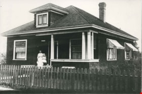
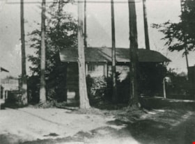
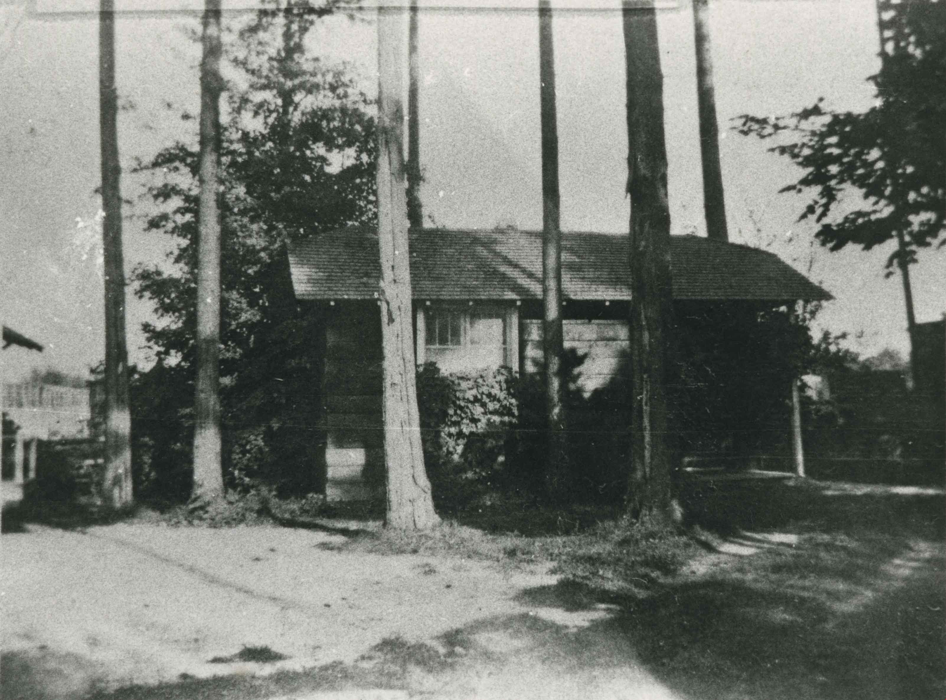
McAskill family home
https://search.heritageburnaby.ca/link/archivedescription35603
- Repository
- City of Burnaby Archives
- Date
- 1914
- Collection/Fonds
- Burnaby Historical Society fonds
- Description Level
- Item
- Physical Description
- 1 photograph : b&w ; 12.7 x 17.8 cm print
- Scope and Content
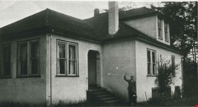
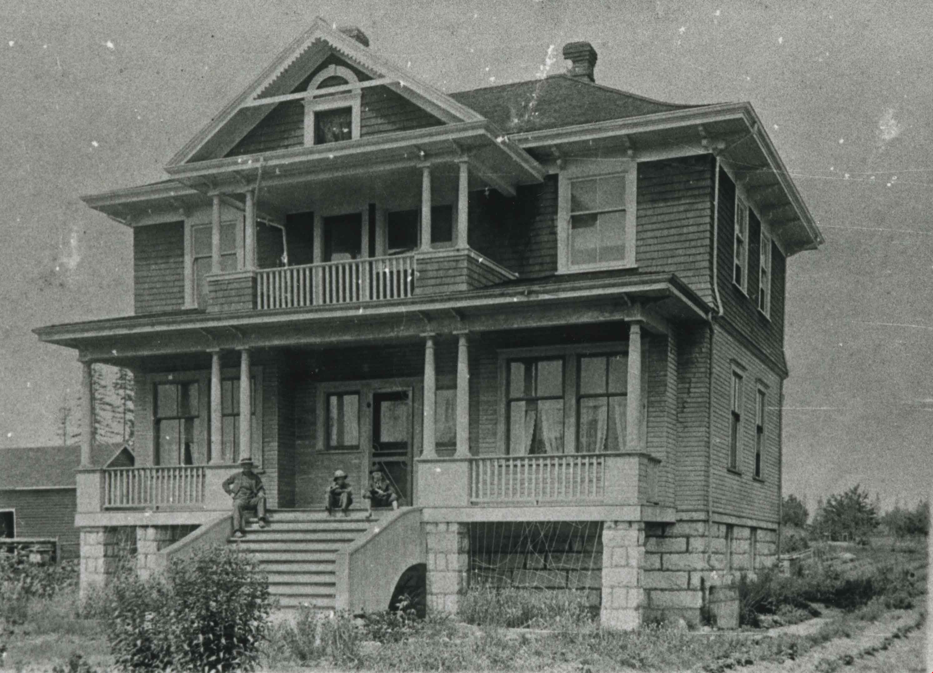
- Photograph of the McAskill family home, 7435 Edmonds Street at Humphries Avenue. This later became the site of Eastburn Community Centre.
- Repository
- City of Burnaby Archives
- Date
- 1914
- Collection/Fonds
- Burnaby Historical Society fonds
- Subseries
- Pioneer Tales subseries
- Physical Description
- 1 photograph : b&w ; 12.7 x 17.8 cm print
- Description Level
- Item
- Record No.
- 204-461
- Access Restriction
- No restrictions
- Reproduction Restriction
- No known restrictions
- Accession Number
- BHS1988-03
- Scope and Content
- Photograph of the McAskill family home, 7435 Edmonds Street at Humphries Avenue. This later became the site of Eastburn Community Centre.
- Subjects
- Buildings - Residential - Houses
- Media Type
- Photograph
- Notes
- Title based on contents of photograph
- Geographic Access
- Edmonds Street
- Street Address
- 7435 Edmonds Street
- Historic Neighbourhood
- Edmonds (Historic Neighbourhood)
- Planning Study Area
- Richmond Park Area
Images
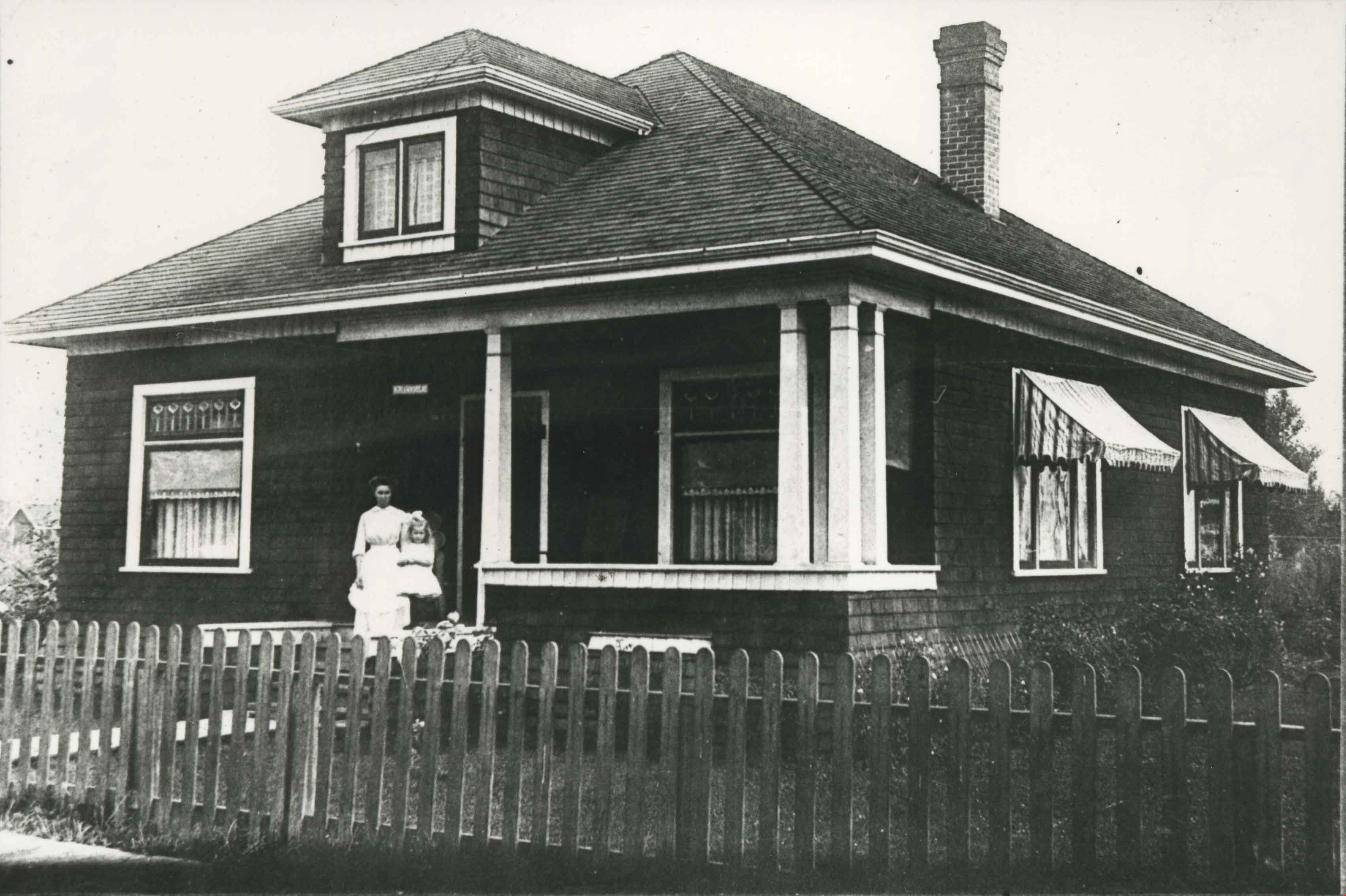
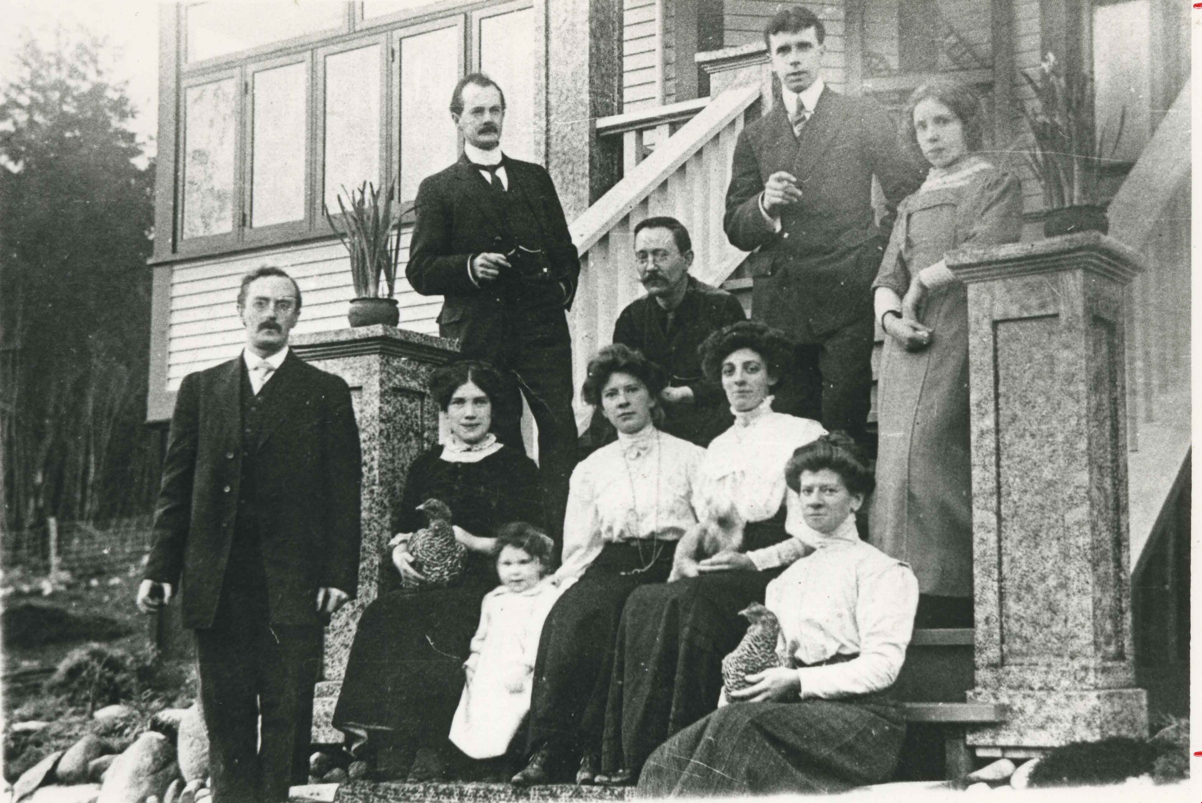
Tidball-Cram family home
https://search.heritageburnaby.ca/link/archivedescription35605
- Repository
- City of Burnaby Archives
- Date
- 1908 (date of original), copied 1986
- Collection/Fonds
- Burnaby Historical Society fonds
- Description Level
- Item
- Physical Description
- 1 photograph : b&w ; 12.7 x 17.8 cm print
- Scope and Content
- Photograph of the Tidball-Cram family home, 3267Kingsway (later renumbered 5489 Kingsway) at Denbigh Avenue (Denbigh did not exist at the time; the area was the family's orchard). Grandfather Tidball (left) and Grandmother Tidball (right) are on the porch. The Tidball's daughter and son-in-law, Ali…
- Repository
- City of Burnaby Archives
- Date
- 1908 (date of original), copied 1986
- Collection/Fonds
- Burnaby Historical Society fonds
- Subseries
- Pioneer Tales subseries
- Physical Description
- 1 photograph : b&w ; 12.7 x 17.8 cm print
- Description Level
- Item
- Record No.
- 204-463
- Access Restriction
- No restrictions
- Reproduction Restriction
- No known restrictions
- Accession Number
- BHS1988-03
- Scope and Content
- Photograph of the Tidball-Cram family home, 3267Kingsway (later renumbered 5489 Kingsway) at Denbigh Avenue (Denbigh did not exist at the time; the area was the family's orchard). Grandfather Tidball (left) and Grandmother Tidball (right) are on the porch. The Tidball's daughter and son-in-law, Alice and William Cram, and their family joined the Tidballs on their farm after moving to Burnaby from the United States. The Crams and Tidballs produced and sold fruit, produce, honey, and cottage cheese.
- Subjects
- Buildings - Residential - Houses
- Media Type
- Photograph
- Notes
- Title based on contents of photograph
- Geographic Access
- Kingsway
- Street Address
- 5489 Kingsway
- Historic Neighbourhood
- Central Park (Historic Neighbourhood)
- Planning Study Area
- Windsor Area
Images


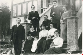
McGeachie family
https://search.heritageburnaby.ca/link/archivedescription35606
- Repository
- City of Burnaby Archives
- Date
- 1925 (date of original), copied 1986
- Collection/Fonds
- Burnaby Historical Society fonds
- Description Level
- Item
- Physical Description
- 1 photograph : b&w ; 12.7 x 17.8 cm print
- Scope and Content
- Photograph of the McGeachie family. Standing: John McGeachie (father). On right: Helen McGeachie (mother). Left to right: Thomas McGeachie, Florence Mary McGeachie, John Aloysius "Jack" McGeachie (wearing tie), and Roderick Noel McGeachie.
- Repository
- City of Burnaby Archives
- Date
- 1925 (date of original), copied 1986
- Collection/Fonds
- Burnaby Historical Society fonds
- Subseries
- Pioneer Tales subseries
- Physical Description
- 1 photograph : b&w ; 12.7 x 17.8 cm print
- Description Level
- Item
- Record No.
- 204-464
- Access Restriction
- No restrictions
- Reproduction Restriction
- No known restrictions
- Accession Number
- BHS1988-03
- Scope and Content
- Photograph of the McGeachie family. Standing: John McGeachie (father). On right: Helen McGeachie (mother). Left to right: Thomas McGeachie, Florence Mary McGeachie, John Aloysius "Jack" McGeachie (wearing tie), and Roderick Noel McGeachie.
- Subjects
- Documentary Artifacts - Portraits
- Names
- McGeachie, Florence Mary
- McGeachie, Helen
- McGeachie, John
- McGeachie, John Aloysius "Jack"
- McGeachie, Roderick Noel
- McGeachie, Thomas
- Media Type
- Photograph
- Notes
- Title based on contents of photograph
Images

Holdom family
https://search.heritageburnaby.ca/link/archivedescription35608
- Repository
- City of Burnaby Archives
- Date
- 1912 (date of original), copied 1986
- Collection/Fonds
- Burnaby Historical Society fonds
- Description Level
- Item
- Physical Description
- 1 photograph : b&w ; 12.7 x 17.8 cm print
- Scope and Content
- Photograph of the Holdom family with friends and relations on the front steps of "Dunsford," the Holdom family home. Identified are (front row, from left) Walter Holdom and Hetty Holdom, who were married; (back row, left) Charles Holdom, brother of Walter Holdom; and, (right) Min Turner, sister of…
- Repository
- City of Burnaby Archives
- Date
- 1912 (date of original), copied 1986
- Collection/Fonds
- Burnaby Historical Society fonds
- Subseries
- Pioneer Tales subseries
- Physical Description
- 1 photograph : b&w ; 12.7 x 17.8 cm print
- Description Level
- Item
- Record No.
- 204-466
- Access Restriction
- No restrictions
- Reproduction Restriction
- No known restrictions
- Accession Number
- BHS1988-03
- Scope and Content
- Photograph of the Holdom family with friends and relations on the front steps of "Dunsford," the Holdom family home. Identified are (front row, from left) Walter Holdom and Hetty Holdom, who were married; (back row, left) Charles Holdom, brother of Walter Holdom; and, (right) Min Turner, sister of Hetty Holdom.
- Names
- Holdom, Charles "Charlie"
- Holdom, Henrietta Mary "Hetty" Turner
- Holdom, Walter John
- Turner, Minnie
- Media Type
- Photograph
- Notes
- Title based on contents of photograph
- Geographic Access
- Hastings Street
- Howard Avenue
- Historic Neighbourhood
- Capitol Hill (Historic Neighbourhood)
- Planning Study Area
- Capitol Hill Area
Images
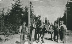
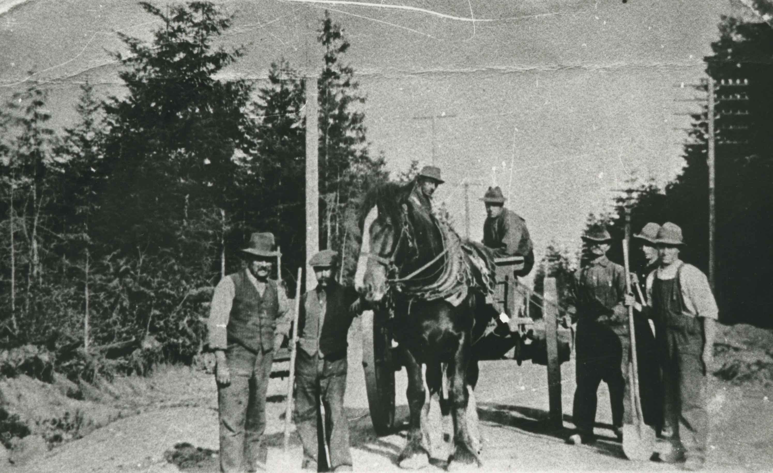
Municipal road crew
https://search.heritageburnaby.ca/link/archivedescription35609
- Repository
- City of Burnaby Archives
- Date
- 1911 (date of original), copied 1986
- Collection/Fonds
- Burnaby Historical Society fonds
- Description Level
- Item
- Physical Description
- 1 photograph : b&w ; 12.7 x 17.8 cm print
- Scope and Content
- Photograph of a municipal road crew. Identified: (far left) George H. Thomson. This was George Thomson's first job after arriving in Burnaby from London, England. He would later open Thomson's Cash Grocery stores. Note the horse drawn wagon used to haul materials.
- Repository
- City of Burnaby Archives
- Date
- 1911 (date of original), copied 1986
- Collection/Fonds
- Burnaby Historical Society fonds
- Subseries
- Pioneer Tales subseries
- Physical Description
- 1 photograph : b&w ; 12.7 x 17.8 cm print
- Description Level
- Item
- Record No.
- 204-467
- Access Restriction
- No restrictions
- Reproduction Restriction
- No known restrictions
- Accession Number
- BHS1988-03
- Scope and Content
- Photograph of a municipal road crew. Identified: (far left) George H. Thomson. This was George Thomson's first job after arriving in Burnaby from London, England. He would later open Thomson's Cash Grocery stores. Note the horse drawn wagon used to haul materials.
- Subjects
- Transportation - Horses
- Occupations - Labourers
- Construction - Road Construction
- Transportation - Wagons
- Names
- Thomson, George H.
- Media Type
- Photograph
- Notes
- Title based on contents of photograph
Images
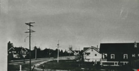
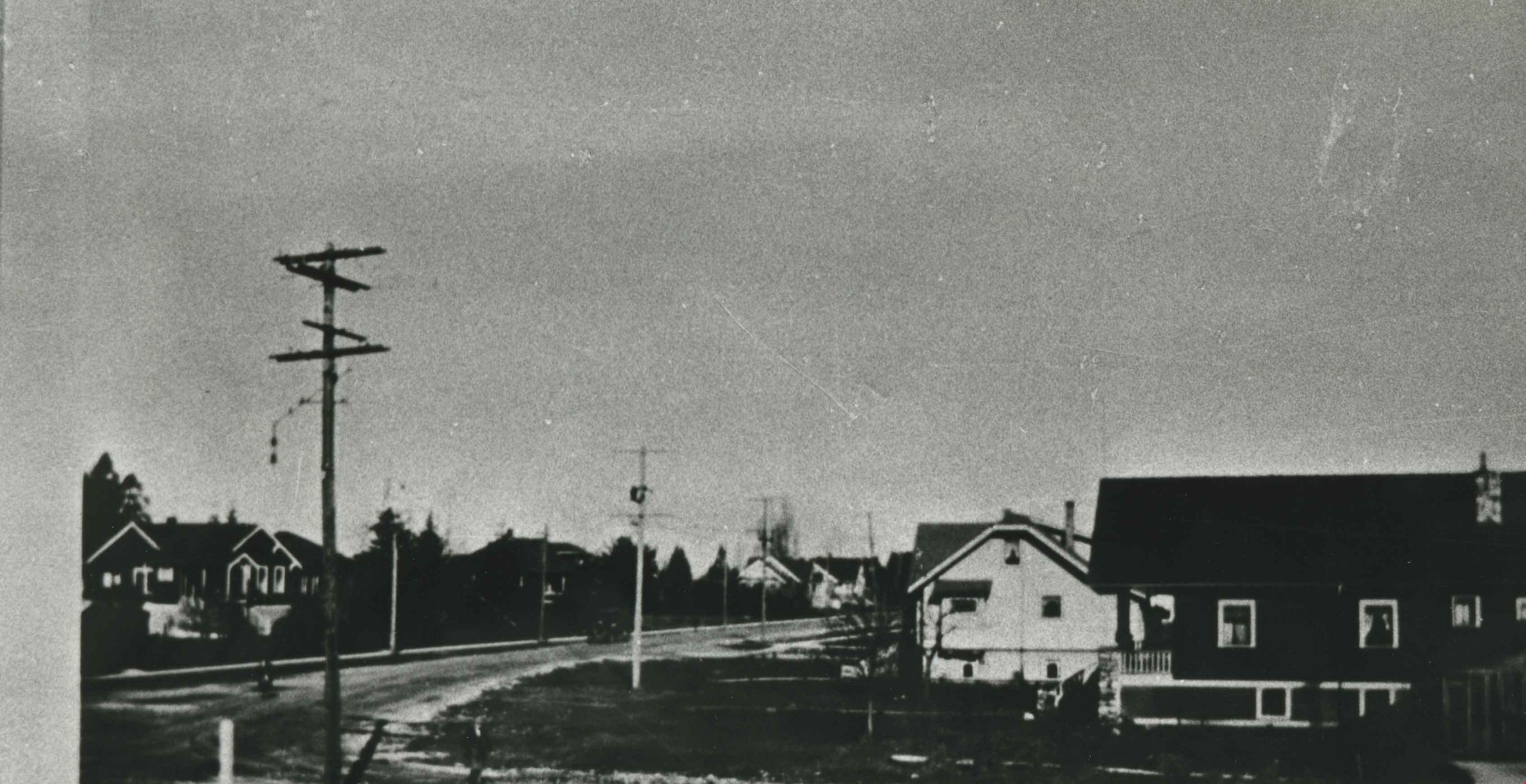
Davis family neighbourhood
https://search.heritageburnaby.ca/link/archivedescription35610
- Repository
- City of Burnaby Archives
- Date
- 1929 (date of original), copied 1986
- Collection/Fonds
- Burnaby Historical Society fonds
- Description Level
- Item
- Physical Description
- 1 photograph : b&w ; 10.2 x 17.8 cm print
- Scope and Content
- Photograph of the neighbourhood where the Davis family lived, looking up Royal Oak Road at Imperial Street, taken from an upstairs room of the Davis home. Arthur Davis later built a corner house at 2345 Royal Oak, right next to house from which this photograph was taken.
- Repository
- City of Burnaby Archives
- Date
- 1929 (date of original), copied 1986
- Collection/Fonds
- Burnaby Historical Society fonds
- Subseries
- Pioneer Tales subseries
- Physical Description
- 1 photograph : b&w ; 10.2 x 17.8 cm print
- Description Level
- Item
- Record No.
- 204-468
- Access Restriction
- No restrictions
- Reproduction Restriction
- No known restrictions
- Accession Number
- BHS1988-03
- Scope and Content
- Photograph of the neighbourhood where the Davis family lived, looking up Royal Oak Road at Imperial Street, taken from an upstairs room of the Davis home. Arthur Davis later built a corner house at 2345 Royal Oak, right next to house from which this photograph was taken.
- Subjects
- Geographic Features - Neighbourhoods
- Media Type
- Photograph
- Notes
- Title based on contents of photograph
- Photograph has been cropped
- Geographic Access
- Royal Oak Avenue
- Historic Neighbourhood
- Central Park (Historic Neighbourhood)
- Planning Study Area
- Windsor Area
Images

Alta Vista Baptist Church Sunday School class
https://search.heritageburnaby.ca/link/archivedescription35611
- Repository
- City of Burnaby Archives
- Date
- 1928
- Collection/Fonds
- Burnaby Historical Society fonds
- Description Level
- Item
- Physical Description
- 1 photograph : b&w ; 12.7 x 17.8 cm print
- Scope and Content
- Photograph of members of the Alta Vista Baptist Church Sunday school class at the Jubilee Interurban train Station, on the way to a Picnic at Second Beach. Included in the photograph are, from left; Pearl Christian, Joy [last name unknown], Phyllis Smith, Ivy Smith, Dorothy Douglas, Grace Harrison,…
- Repository
- City of Burnaby Archives
- Date
- 1928
- Collection/Fonds
- Burnaby Historical Society fonds
- Subseries
- Pioneer Tales subseries
- Physical Description
- 1 photograph : b&w ; 12.7 x 17.8 cm print
- Description Level
- Item
- Record No.
- 204-469
- Access Restriction
- No restrictions
- Reproduction Restriction
- No known restrictions
- Accession Number
- BHS1988-03
- Scope and Content
- Photograph of members of the Alta Vista Baptist Church Sunday school class at the Jubilee Interurban train Station, on the way to a Picnic at Second Beach. Included in the photograph are, from left; Pearl Christian, Joy [last name unknown], Phyllis Smith, Ivy Smith, Dorothy Douglas, Grace Harrison, [unidentified]. Mrs. Nellie Davis [not pictured] taught this class.
- Names
- Alta Vista Baptist Church
- British Columbia Electric Railway Company
- Christian, Pearl
- Smith, Phyllis
- Smith, Ivy
- Douglas, Dorothy
- Harrison, Grace
- Media Type
- Photograph
- Notes
- Title based on contents of photograph
- Geographic Access
- Central Park Interurban line
- Historic Neighbourhood
- Central Park (Historic Neighbourhood)
- Planning Study Area
- Maywood Area
Images

Gardner family home
https://search.heritageburnaby.ca/link/archivedescription35612
- Repository
- City of Burnaby Archives
- Date
- 1925 (date of original), copied 1986
- Collection/Fonds
- Burnaby Historical Society fonds
- Description Level
- Item
- Physical Description
- 1 photograph : b&w ; 12.7 x 17.8 cm print
- Scope and Content
- Photograph of the Gardner family home at 2619 Fern Avenue, which later became the site of Bonsor Park at 6550 Bonsor Avenue. The house was built before the First World War, and the Gardners moved into it in 1925.
- Repository
- City of Burnaby Archives
- Date
- 1925 (date of original), copied 1986
- Collection/Fonds
- Burnaby Historical Society fonds
- Subseries
- Pioneer Tales subseries
- Physical Description
- 1 photograph : b&w ; 12.7 x 17.8 cm print
- Description Level
- Item
- Record No.
- 204-470
- Access Restriction
- No restrictions
- Reproduction Restriction
- No known restrictions
- Accession Number
- BHS1988-03
- Scope and Content
- Photograph of the Gardner family home at 2619 Fern Avenue, which later became the site of Bonsor Park at 6550 Bonsor Avenue. The house was built before the First World War, and the Gardners moved into it in 1925.
- Subjects
- Buildings - Residential - Houses
- Media Type
- Photograph
- Notes
- Title based on contents of photograph
- Geographic Access
- Fern Avenue
- Bonsor Avenue
- Street Address
- 6550 Bonsor Avenue
- Historic Neighbourhood
- Central Park (Historic Neighbourhood)
- Planning Study Area
- Marlborough Area
Images
Harry and Sara Gardner
https://search.heritageburnaby.ca/link/archivedescription35613
- Repository
- City of Burnaby Archives
- Date
- 1928 (date of original), copied 1986
- Collection/Fonds
- Burnaby Historical Society fonds
- Description Level
- Item
- Physical Description
- 1 photograph : b&w ; 12.7 x 17.8 cm print
- Scope and Content
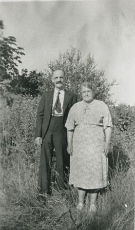
- Photograph of Harry Norman Gardner and his wife, Sarah Ann Gardner. They had two children: Hazel and Urban. This photograph was taken in the garden of the family home at 2619 Fern Avenue, which later became the site of Bonsor Park at 6550 Bonsor Avenue.
- Repository
- City of Burnaby Archives
- Date
- 1928 (date of original), copied 1986
- Collection/Fonds
- Burnaby Historical Society fonds
- Subseries
- Pioneer Tales subseries
- Physical Description
- 1 photograph : b&w ; 12.7 x 17.8 cm print
- Description Level
- Item
- Record No.
- 204-471
- Access Restriction
- No restrictions
- Reproduction Restriction
- No known restrictions
- Accession Number
- BHS1988-03
- Scope and Content
- Photograph of Harry Norman Gardner and his wife, Sarah Ann Gardner. They had two children: Hazel and Urban. This photograph was taken in the garden of the family home at 2619 Fern Avenue, which later became the site of Bonsor Park at 6550 Bonsor Avenue.
- Media Type
- Photograph
- Notes
- Title based on contents of photograph
- Geographic Access
- Fern Avenue
- Bonsor Avenue
- Street Address
- 6550 Bonsor Avenue
- Historic Neighbourhood
- Central Park (Historic Neighbourhood)
- Planning Study Area
- Marlborough Area
Images


Gardner Family Chicken Farm
https://search.heritageburnaby.ca/link/archivedescription35614
- Repository
- City of Burnaby Archives
- Date
- 1927 (date of original), copied 1986
- Collection/Fonds
- Burnaby Historical Society fonds
- Description Level
- Item
- Physical Description
- 1 photograph : b&w ; 12.7 x 17.8 cm print
- Scope and Content
- Photograph of (left to right) Harry Gardner and Sarah Gardner in front of the property they rented for use as a chicken farm. 2604 Fern Avenue was located across from the family home, and for two years the family used it as a fryer chicken and egg farm. The Bonsor recreation centre was later buil…
- Repository
- City of Burnaby Archives
- Date
- 1927 (date of original), copied 1986
- Collection/Fonds
- Burnaby Historical Society fonds
- Subseries
- Pioneer Tales subseries
- Physical Description
- 1 photograph : b&w ; 12.7 x 17.8 cm print
- Description Level
- Item
- Record No.
- 204-472
- Access Restriction
- No restrictions
- Reproduction Restriction
- No known restrictions
- Accession Number
- BHS1988-03
- Scope and Content
- Photograph of (left to right) Harry Gardner and Sarah Gardner in front of the property they rented for use as a chicken farm. 2604 Fern Avenue was located across from the family home, and for two years the family used it as a fryer chicken and egg farm. The Bonsor recreation centre was later built there after it became the site of Bonsor Park at 6550 Bonsor Avenue.
- Subjects
- Agriculture - Farms
- Media Type
- Photograph
- Notes
- Title based on contents of photograph
- Geographic Access
- Fern Avenue
- Bonsor Avenue
- Street Address
- 6550 Bonsor Avenue
- Historic Neighbourhood
- Central Park (Historic Neighbourhood)
- Planning Study Area
- Marlborough Area
Images


Gardner family farm
https://search.heritageburnaby.ca/link/archivedescription35615
- Repository
- City of Burnaby Archives
- Date
- 1927 (date of original), copied 1986
- Collection/Fonds
- Burnaby Historical Society fonds
- Description Level
- Item
- Physical Description
- 1 photograph : b&w ; 12.7 x 17.8 cm print
- Scope and Content
- Photograph of Hazel Gardner and a pet goat at the family chicken farm. The centre house in the background is the family home across Fern Avenue. This area later became the site of Bonsor Park at 6550 Bonsor Avenue.
- Repository
- City of Burnaby Archives
- Date
- 1927 (date of original), copied 1986
- Collection/Fonds
- Burnaby Historical Society fonds
- Subseries
- Pioneer Tales subseries
- Physical Description
- 1 photograph : b&w ; 12.7 x 17.8 cm print
- Description Level
- Item
- Record No.
- 204-473
- Access Restriction
- No restrictions
- Reproduction Restriction
- No known restrictions
- Accession Number
- BHS1988-03
- Scope and Content
- Photograph of Hazel Gardner and a pet goat at the family chicken farm. The centre house in the background is the family home across Fern Avenue. This area later became the site of Bonsor Park at 6550 Bonsor Avenue.
- Subjects
- Animals - Goats
- Agriculture - Farms
- Names
- Willis, Hazel Gardner
- Media Type
- Photograph
- Notes
- Title based on contents of photograph
- Geographic Access
- Fern Avenue
- Bonsor Avenue
- Street Address
- 6550 Bonsor Avenue
- Historic Neighbourhood
- Central Park (Historic Neighbourhood)
- Planning Study Area
- Marlborough Area
Images

Gardner Family
https://search.heritageburnaby.ca/link/archivedescription35616
- Repository
- City of Burnaby Archives
- Date
- 1944 (date of original), copied 1986
- Collection/Fonds
- Burnaby Historical Society fonds
- Description Level
- Item
- Physical Description
- 1 photograph : b&w ; 12.7 x 17.8 cm print
- Scope and Content
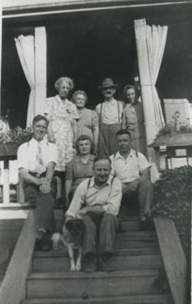
- Photograph of the Gardner family and other relatives. Identified: (front) Urban Gardner (brother) with pet dog, Toby; (2nd row, left to right) Will Swain (uncle visiting from Winnipeg), Hazel Gardner Willis (sister), Fred Willis (husband of Hazel); (back row, left to right) Nell Pentland (aunt vis…
- Repository
- City of Burnaby Archives
- Date
- 1944 (date of original), copied 1986
- Collection/Fonds
- Burnaby Historical Society fonds
- Subseries
- Pioneer Tales subseries
- Physical Description
- 1 photograph : b&w ; 12.7 x 17.8 cm print
- Description Level
- Item
- Record No.
- 204-474
- Access Restriction
- No restrictions
- Reproduction Restriction
- No known restrictions
- Accession Number
- BHS1988-03
- Scope and Content
- Photograph of the Gardner family and other relatives. Identified: (front) Urban Gardner (brother) with pet dog, Toby; (2nd row, left to right) Will Swain (uncle visiting from Winnipeg), Hazel Gardner Willis (sister), Fred Willis (husband of Hazel); (back row, left to right) Nell Pentland (aunt visiting from Winnipeg), Sarah Gardner (mother), Harry Gardner (father), and an unidentified woman. This later became the site of Bonsor Park at 6550 Bonsor Avenue.
- Subjects
- Animals - Dogs
- Names
- Gardner, Harry Norman
- Gardner, Sarah Ann Swain
- Gardner, Urban
- Pentland, Nell
- Swain, Will
- Willis, Fred
- Willis, Hazel Gardner
- Media Type
- Photograph
- Notes
- Title based on contents of photograph
- Geographic Access
- Bonsor Avenue
- Street Address
- 6550 Bonsor Avenue
- Historic Neighbourhood
- Central Park (Historic Neighbourhood)
- Planning Study Area
- Marlborough Area
Images

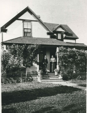
Waplington family home
https://search.heritageburnaby.ca/link/archivedescription35617
- Repository
- City of Burnaby Archives
- Date
- 1930 (date of original), copied 1986
- Collection/Fonds
- Burnaby Historical Society fonds
- Description Level
- Item
- Physical Description
- 1 photograph : b&w ; 12.7 x 17.8 cm print
- Scope and Content
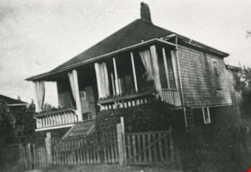
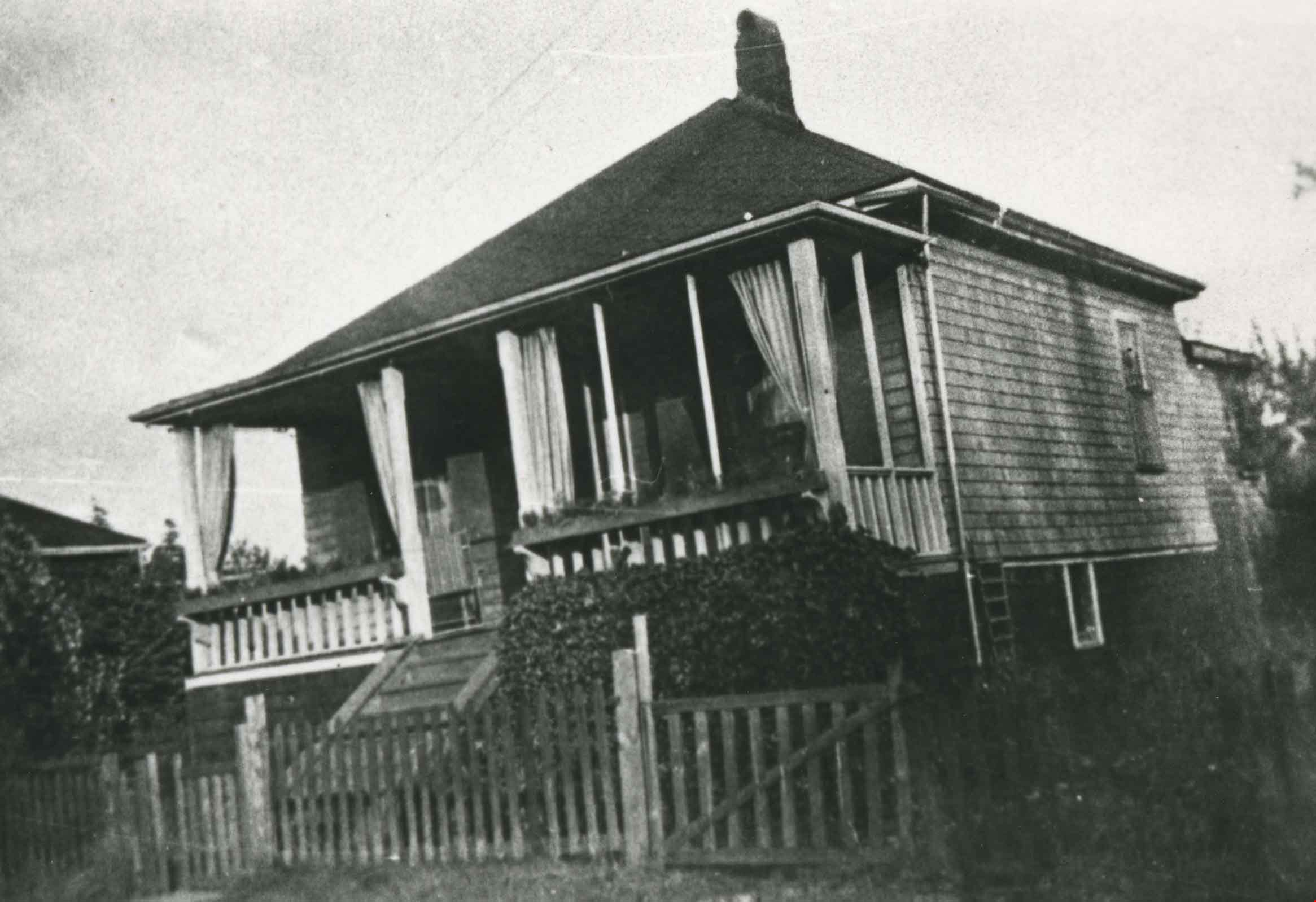
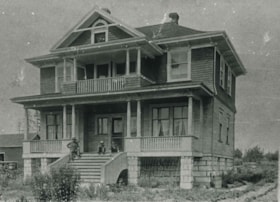
- Photograph of the Waplington family home. This house was originally "Brookfield," Claude Hill's family home. Jack Waplington bought the house in 1925 and engaged Claude Hill's brother, Bernard, to renovate it. The property later became the site of the Burnaby Village Museum. The man in the photogra…
- Repository
- City of Burnaby Archives
- Date
- 1930 (date of original), copied 1986
- Collection/Fonds
- Burnaby Historical Society fonds
- Subseries
- Pioneer Tales subseries
- Physical Description
- 1 photograph : b&w ; 12.7 x 17.8 cm print
- Description Level
- Item
- Record No.
- 204-475
- Access Restriction
- No restrictions
- Reproduction Restriction
- No known restrictions
- Accession Number
- BHS1988-03
- Scope and Content
- Photograph of the Waplington family home. This house was originally "Brookfield," Claude Hill's family home. Jack Waplington bought the house in 1925 and engaged Claude Hill's brother, Bernard, to renovate it. The property later became the site of the Burnaby Village Museum. The man in the photograph may be Claude Hill.
- Subjects
- Buildings - Residential - Houses
- Media Type
- Photograph
- Notes
- Title based on contents of photograph
- Geographic Access
- Deer Lake Avenue
- Street Address
- 6501 Deer Lake Avenue
- Historic Neighbourhood
- Burnaby Lake (Historic Neighbourhood)
- Planning Study Area
- Morley-Buckingham Area
Images

Naud family
https://search.heritageburnaby.ca/link/archivedescription35619
- Repository
- City of Burnaby Archives
- Date
- 1903 (date of original), copied 1986
- Collection/Fonds
- Burnaby Historical Society fonds
- Description Level
- Item
- Physical Description
- 1 photograph : b&w ; 12.7 x 17.8 cm print
- Scope and Content
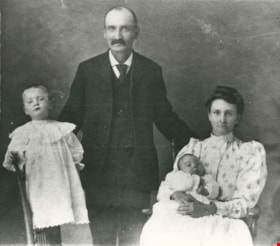
- Photograph of the Naud family. Left to right: Bernie Naud, Georges Naud, and Charlsie Elizabeth Sims Naud holding baby Ernie Naud.
- Repository
- City of Burnaby Archives
- Date
- 1903 (date of original), copied 1986
- Collection/Fonds
- Burnaby Historical Society fonds
- Subseries
- Pioneer Tales subseries
- Physical Description
- 1 photograph : b&w ; 12.7 x 17.8 cm print
- Description Level
- Item
- Record No.
- 204-477
- Access Restriction
- No restrictions
- Reproduction Restriction
- No known restrictions
- Accession Number
- BHS1988-03
- Scope and Content
- Photograph of the Naud family. Left to right: Bernie Naud, Georges Naud, and Charlsie Elizabeth Sims Naud holding baby Ernie Naud.
- Subjects
- Documentary Artifacts - Portraits
- Media Type
- Photograph
- Notes
- Title based on contents of photograph
Images

Naud family home
https://search.heritageburnaby.ca/link/archivedescription35621
- Repository
- City of Burnaby Archives
- Date
- 1910 (date of original), copied 1986
- Collection/Fonds
- Burnaby Historical Society fonds
- Description Level
- Item
- Physical Description
- 1 photograph : b&w ; 12.7 x 17.8 cm print
- Scope and Content
- Photograph of the Naud family home. Left to right: Georges Naud (father), Ernie Naud (brother), and Bernie Naud (brother) are on the front porch. The house was green on its upper half and light grey at the bottom. It was located at 4737 Victory Street.
- Repository
- City of Burnaby Archives
- Date
- 1910 (date of original), copied 1986
- Collection/Fonds
- Burnaby Historical Society fonds
- Subseries
- Pioneer Tales subseries
- Physical Description
- 1 photograph : b&w ; 12.7 x 17.8 cm print
- Description Level
- Item
- Record No.
- 204-479
- Access Restriction
- No restrictions
- Reproduction Restriction
- No known restrictions
- Accession Number
- BHS1988-03
- Scope and Content
- Photograph of the Naud family home. Left to right: Georges Naud (father), Ernie Naud (brother), and Bernie Naud (brother) are on the front porch. The house was green on its upper half and light grey at the bottom. It was located at 4737 Victory Street.
- Subjects
- Buildings - Residential - Houses
- Media Type
- Photograph
- Notes
- Title based on contents of photograph
- Geographic Access
- Victory Street
- Street Address
- 4737 Victory Street
- Historic Neighbourhood
- Alta-Vista (Historic Neighbourhood)
- Planning Study Area
- Sussex-Nelson Area
Images
Nelson Avenue Public School class
https://search.heritageburnaby.ca/link/archivedescription35622
- Repository
- City of Burnaby Archives
- Date
- 1929 (date of original), copied 1986
- Collection/Fonds
- Burnaby Historical Society fonds
- Description Level
- Item
- Physical Description
- 1 photograph : b&w ; 12.7 x 17.8 cm print
- Scope and Content
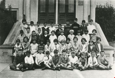
- Photograph of Nelson Avenue Public School, Grade four class. From top, left to right; Teacher, Mrs. McGuffin, John Reid, George Goddard, Eddie Hitchens, Jackie Norman, Roy Franklin, [first name unknown] Flemming, [first name unknown] Flemming, Bobby [Davis]. Third row; [unidentified], Joey Davis, M…
- Repository
- City of Burnaby Archives
- Date
- 1929 (date of original), copied 1986
- Collection/Fonds
- Burnaby Historical Society fonds
- Subseries
- Pioneer Tales subseries
- Physical Description
- 1 photograph : b&w ; 12.7 x 17.8 cm print
- Description Level
- Item
- Record No.
- 204-480
- Access Restriction
- No restrictions
- Reproduction Restriction
- No known restrictions
- Accession Number
- BHS1988-03
- Scope and Content
- Photograph of Nelson Avenue Public School, Grade four class. From top, left to right; Teacher, Mrs. McGuffin, John Reid, George Goddard, Eddie Hitchens, Jackie Norman, Roy Franklin, [first name unknown] Flemming, [first name unknown] Flemming, Bobby [Davis]. Third row; [unidentified], Joey Davis, Mirrim Harper, Ernie Carpenter, [unidentified], [unidentified], Joy [Wynn], Dagmar Anderson, [unidentified], [unidentified], Betty Smith. Second row; Pearl Hutton, "twin" Phyllis [last name unknown], Betty Porter, [unidentified], Ina Dearing, Mary Beech, Muriel Davis (later Jean Skelhorne), Dot Lockwood, [unidentified "twin"], Kay Bates, Vera Keig, Marg Herd. Front row; [unidentified], Sam Hughes, Clarence Wesley, George Robertson, Art Butchart, Sandy Stewart, [unidentified], [unidentified], [first name unknown] Harrison, Harvey Smith.
- Names
- Nelson Avenue School
- Media Type
- Photograph
- Notes
- Title based on contents of photograph
- Geographic Access
- Irmin Street
- Street Address
- 4850 Irmin Street
- Historic Neighbourhood
- Alta-Vista (Historic Neighbourhood)
- Planning Study Area
- Sussex-Nelson Area
Images
Oasis Tea Garden and Tourist Camp
https://search.heritageburnaby.ca/link/archivedescription35623
- Repository
- City of Burnaby Archives
- Date
- 1925 (date of original), copied 1986
- Collection/Fonds
- Burnaby Historical Society fonds
- Description Level
- Item
- Physical Description
- 1 photograph : b&w ; 12.7 x 17.8 cm print
- Scope and Content
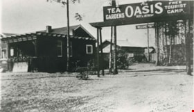
- Photograph of the Oasis tea garden and tourist camp at 2675 Kingsway (Pacific Highway). It was later renumbered 6105 Kingsway. Guests could pitch tents for free at the campground and patronize the tea garden. The complex was operated by the Raymer family.
- Repository
- City of Burnaby Archives
- Date
- 1925 (date of original), copied 1986
- Collection/Fonds
- Burnaby Historical Society fonds
- Subseries
- Pioneer Tales subseries
- Physical Description
- 1 photograph : b&w ; 12.7 x 17.8 cm print
- Description Level
- Item
- Record No.
- 204-481
- Access Restriction
- No restrictions
- Reproduction Restriction
- No known restrictions
- Accession Number
- BHS1988-03
- Scope and Content
- Photograph of the Oasis tea garden and tourist camp at 2675 Kingsway (Pacific Highway). It was later renumbered 6105 Kingsway. Guests could pitch tents for free at the campground and patronize the tea garden. The complex was operated by the Raymer family.
- Names
- Oasis
- Media Type
- Photograph
- Notes
- Title based on contents of photograph
- Geographic Access
- Kingsway
- Street Address
- 6105 Kingsway
- Planning Study Area
- Windsor Area
Images

Oasis Tourist Camp cabins
https://search.heritageburnaby.ca/link/archivedescription35627
- Repository
- City of Burnaby Archives
- Date
- 1929 (date of original), copied 1986
- Collection/Fonds
- Burnaby Historical Society fonds
- Description Level
- Item
- Physical Description
- 1 photograph : b&w ; 12.7 x 17.8 cm print
- Scope and Content
- Photograph of the first of ten rental cabins built at The Oasis tourist camp. The Oasis was located at 2675 Kingsway (Pacific Highway). It was later renumbered 6105 Kingsway.
- Repository
- City of Burnaby Archives
- Date
- 1929 (date of original), copied 1986
- Collection/Fonds
- Burnaby Historical Society fonds
- Subseries
- Pioneer Tales subseries
- Physical Description
- 1 photograph : b&w ; 12.7 x 17.8 cm print
- Description Level
- Item
- Record No.
- 204-485
- Access Restriction
- No restrictions
- Reproduction Restriction
- No known restrictions
- Accession Number
- BHS1988-03
- Scope and Content
- Photograph of the first of ten rental cabins built at The Oasis tourist camp. The Oasis was located at 2675 Kingsway (Pacific Highway). It was later renumbered 6105 Kingsway.
- Names
- Oasis
- Media Type
- Photograph
- Notes
- Title based on contents of photograph
- Geographic Access
- Kingsway
- Street Address
- 6105 Kingsway
- Planning Study Area
- Windsor Area
Images
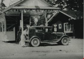
Oasis Gas Station
https://search.heritageburnaby.ca/link/archivedescription35628
- Repository
- City of Burnaby Archives
- Date
- 1935 (date of original), copied 1986
- Collection/Fonds
- Burnaby Historical Society fonds
- Description Level
- Item
- Physical Description
- 1 photograph : b&w ; 12.7 x 17.8 cm print
- Scope and Content
- Photograph of The Oasis gas station, leased by the Raymer family for the first 5 years, then taken over by the Raymers. Roy Raymer is shown pumping gas. The Oasis was located at 2675 Kingsway (Pacific Highway). It was later renumbered 6105 Kingsway.
- Repository
- City of Burnaby Archives
- Date
- 1935 (date of original), copied 1986
- Collection/Fonds
- Burnaby Historical Society fonds
- Subseries
- Pioneer Tales subseries
- Physical Description
- 1 photograph : b&w ; 12.7 x 17.8 cm print
- Description Level
- Item
- Record No.
- 204-486
- Access Restriction
- No restrictions
- Reproduction Restriction
- No known restrictions
- Accession Number
- BHS1988-03
- Scope and Content
- Photograph of The Oasis gas station, leased by the Raymer family for the first 5 years, then taken over by the Raymers. Roy Raymer is shown pumping gas. The Oasis was located at 2675 Kingsway (Pacific Highway). It was later renumbered 6105 Kingsway.
- Names
- Oasis
- Raymer, Roy
- Media Type
- Photograph
- Notes
- Title based on contents of photograph
- Geographic Access
- Kingsway
- Street Address
- 6105 Kingsway
- Planning Study Area
- Windsor Area
Images
