Narrow Results By
Decade
- 2020s 182
- 2010s 226
- 2000s 309
- 1990s 1022
- 1980s 843
- 1970s 2040
- 1960s 736
- 1950s 893
- 1940s 1111
- 1930s 1279
- 1920s 1460
- 1910s 1303
- 1900s 938
- 1890s 348
- 1880s 141
- 1870s 51
- 1860s 52
- 1850s 26
- 1840s 17
- 1830s 8
- 1820s 5
- 1810s 5
- 1800s 8
- 1790s 4
- 1780s 3
- 1770s 3
- 1760s 3
- 1750s 3
- 1740s 3
- 1730s 3
- 1720s 3
- 1710s 5
- 1700s 4
- 1690s 3
- 1680s 4
- 1670s 3
- 1660s 3
- 1650s 3
- 1640s 3
- 1630s 3
- 1620s 3
- 1610s 3
- 1600s 3
- 1520s 1
Subject
- Accidents 4
- Accidents - Automobile Accidents 5
- Accidents - Train Accidents 15
- Adminstrative Groups - Committees 4
- Adornment 83
- Adornment - Jewelry 8
- Adornment - Lapel Pins 83
- Advertising Medium 94
- Advertising Medium - Business Cards 17
- Advertising Medium - Flyer 38
- Advertising Medium - Poster 18
- Advertising Medium - Signs and Signboards 94
William Holmes family records series
https://search.heritageburnaby.ca/link/museumdescription18942
- Repository
- Burnaby Village Museum
- Date
- 1858-1941
- Collection/Fonds
- William Holmes fonds
- Description Level
- Series
- Physical Description
- 5 p. textual records + 1 newspaper clipping
- Scope and Content
- Series consists of letters and land title certificates of William Holmes along with a newspaper clipping refering to the European Ash tree that was planted by the Holmes family on their land in District Lot 1 in Burnaby.
- Repository
- Burnaby Village Museum
- Collection/Fonds
- William Holmes fonds
- Description Level
- Series
- Physical Description
- 5 p. textual records + 1 newspaper clipping
- Scope and Content
- Series consists of letters and land title certificates of William Holmes along with a newspaper clipping refering to the European Ash tree that was planted by the Holmes family on their land in District Lot 1 in Burnaby.
- Accession Code
- BV997.50
- Date
- 1858-1941
- Media Type
- Textual Record
- Notes
- Title based on contents of series
Webster's pocket pronouncing dictionary of the English language : condensed from the original dictionary
https://search.heritageburnaby.ca/link/museumlibrary1605
- Repository
- Burnaby Village Museum
- Collection
- Special Collection
- Material Type
- Book
- Accession Code
- BV985.4002.1
- Call Number
- 423 WEB
- Edition
- Rev. ed.
- Place of Publication
- London
- Publisher
- Ward, Lock & Co., Limited
- Publication Date
- 1858
- Physical Description
- ii-iv, 313 p. ; 13 cm.
- Inscription
- inside front cover: "Miss J.E. Simpson"[handwritten in pencil] "Who'se she?"[handwritten in pencil] printed sticker label inside back cover, gold foil: "Moir's Halifax Canada" pencil notes inside back cover small sticker label, red/gold: "DALGLEISH, Stationer, B. Salterton."
- Library Subject (LOC)
- English language--Dictionaries
- Notes
- "Condensed from the original Dictionary by Noah Webster, LL.D." .
- "with accented vocabularies of classical, scripture, and modern geographical names".
- "containing 10,000 more words than Walker's Dictionary".
- Author's given name and dates : Webster, William G. (William Greenleaf), 1805-1869.
![Sir John A. MacDonald, [186-] thumbnail](/media/hpo/_Data/_BVM_Images/1990/199800440001.jpg?width=280)
Sir John A. MacDonald
https://search.heritageburnaby.ca/link/museumdescription1304
- Repository
- Burnaby Village Museum
- Date
- [186-]
- Collection/Fonds
- Burnaby Village Museum Photograph collection
- Description Level
- Item
- Physical Description
- 1 photograph : sepia ; 14 x 10 cm mounted on heavy card 16.5 x 10.5 cm
- Scope and Content
- Photograph portrait of Canada's first prime minister, Sir John A. MacDonald taken in a photographic studio.
- Repository
- Burnaby Village Museum
- Collection/Fonds
- Burnaby Village Museum Photograph collection
- Description Level
- Item
- Physical Description
- 1 photograph : sepia ; 14 x 10 cm mounted on heavy card 16.5 x 10.5 cm
- Scope and Content
- Photograph portrait of Canada's first prime minister, Sir John A. MacDonald taken in a photographic studio.
- Subjects
- Officials - Prime Ministers
- Names
- MacDonald, John A.
- Accession Code
- BV998.44.1
- Access Restriction
- No restrictions
- Reproduction Restriction
- No known restrictions
- Date
- [186-]
- Media Type
- Photograph
- Scan Resolution
- 600
- Scan Date
- 02-Jun-09
- Scale
- 100
- Notes
- Title based on contents of photograph
- 1 b&w photocopy accompanying
Images
![Sir John A. MacDonald, [186-] thumbnail](/media/hpo/_Data/_BVM_Images/1990/199800440001.jpg)
![Unidentified couple, [186-] thumbnail](/media/hpo/_Data/_BVM_Images/2000/200500590016.jpg?width=280)
Unidentified couple
https://search.heritageburnaby.ca/link/museumdescription1949
- Repository
- Burnaby Village Museum
- Date
- [186-]
- Collection/Fonds
- Burnaby Village Museum Photograph collection
- Description Level
- Item
- Physical Description
- 1 photograph : b&w tintype ; 8 x 6 cm
- Scope and Content
- Photograph of an unidentified couple taken in a photographic studio. The man is standing, wearing a three piece suit (his blazer has been left unbuttoned), with his hat held in his right hand. The woman is seated beside him, in a simple dress with a lace collar.
- Repository
- Burnaby Village Museum
- Collection/Fonds
- Burnaby Village Museum Photograph collection
- Description Level
- Item
- Physical Description
- 1 photograph : b&w tintype ; 8 x 6 cm
- Scope and Content
- Photograph of an unidentified couple taken in a photographic studio. The man is standing, wearing a three piece suit (his blazer has been left unbuttoned), with his hat held in his right hand. The woman is seated beside him, in a simple dress with a lace collar.
- Accession Code
- BV005.59.16
- Access Restriction
- No restrictions
- Reproduction Restriction
- No known restrictions
- Date
- [186-]
- Media Type
- Photograph
- Scan Resolution
- 600
- Scan Date
- 11-Jun-09
- Scale
- 100
- Notes
- Title based on contents of photograph
Images
![Unidentified couple, [186-] thumbnail](/media/hpo/_Data/_BVM_Images/2000/200500590016.jpg)
![Richard Love, [ca. 1870] thumbnail](/media/hpo/_Data/_BVM_Images/2018/2018_0041_0181_001.jpg?width=280)
Richard Love
https://search.heritageburnaby.ca/link/museumdescription9996
- Repository
- Burnaby Village Museum
- Date
- [ca. 1870]
- Collection/Fonds
- Burnaby Village Museum fonds
- Description Level
- Item
- Physical Description
- 1 photograph : b&w negative ; 35 mm
- Scope and Content
- Photograph portrait of Richard Love seated next to a decorative wooden desk. He is seated on a chair with a velvet and tassels and is wearing a large black suit coat, a white blouse with a tie at the collar, pants with long velvet chaps that go up to his knees and cover the tops of his shoes. He is…
- Repository
- Burnaby Village Museum
- Collection/Fonds
- Burnaby Village Museum fonds
- Series
- Jesse Love farmhouse series
- Subseries
- Love family photographs subseries
- Description Level
- Item
- Physical Description
- 1 photograph : b&w negative ; 35 mm
- Scope and Content
- Photograph portrait of Richard Love seated next to a decorative wooden desk. He is seated on a chair with a velvet and tassels and is wearing a large black suit coat, a white blouse with a tie at the collar, pants with long velvet chaps that go up to his knees and cover the tops of his shoes. He is holding a wooden cane between his legs and there is a top hat and a book on top of the desk and a back drop hanging from the wall behind him. Richard Love is the father of Jesse Love.
- Names
- Love, Richard
- Accession Code
- BV018.41.181
- Access Restriction
- No restrictions
- Reproduction Restriction
- May be restricted by third party rights
- Date
- [ca. 1870]
- Media Type
- Photograph
- Scan Resolution
- 2400
- Scan Date
- 4-Mar-2019
- Scale
- 100
- Photographer
- Dodson, Z.
- Notes
- Title based on contents of photograph
- 1 b&w copy print accompanying
- Stamp in black ink on verso of original photograph reads: "Z.DODSON, / Photographer / PROSPECT PLACE, / NEAR VICTORIA STREET / SWINDON."
Images
![Richard Love, [ca. 1870] thumbnail](/media/hpo/_Data/_BVM_Images/2018/2018_0041_0181_001.jpg)
![Elizabeth Love, [ca. 1870] thumbnail](/media/hpo/_Data/_BVM_Images/2018/2018_0041_0182_001.jpg?width=280)
Elizabeth Love
https://search.heritageburnaby.ca/link/museumdescription9997
- Repository
- Burnaby Village Museum
- Date
- [ca. 1870]
- Collection/Fonds
- Burnaby Village Museum fonds
- Description Level
- Item
- Physical Description
- 1 photograph : b&w negative ; 35 mm
- Scope and Content
- Photograph portrait of Elizabeth Love (nee Prince) seated next to a decorative wooden desk with a book on top. She is seated on a velvet chair and is wearing a long black silk dress with a decorative lace collar and bonnet. Eizabeth Love was married to Richard Love and is the mother of Jesse Love.
- Repository
- Burnaby Village Museum
- Collection/Fonds
- Burnaby Village Museum fonds
- Series
- Jesse Love farmhouse series
- Subseries
- Love family photographs subseries
- Description Level
- Item
- Physical Description
- 1 photograph : b&w negative ; 35 mm
- Scope and Content
- Photograph portrait of Elizabeth Love (nee Prince) seated next to a decorative wooden desk with a book on top. She is seated on a velvet chair and is wearing a long black silk dress with a decorative lace collar and bonnet. Eizabeth Love was married to Richard Love and is the mother of Jesse Love.
- Accession Code
- BV018.41.182
- Access Restriction
- No restrictions
- Reproduction Restriction
- May be restricted by third party rights
- Date
- [ca. 1870]
- Media Type
- Photograph
- Scan Resolution
- 2400
- Scan Date
- 4-Mar-2019
- Scale
- 100
- Notes
- Title based on contents of photograph
- 1 b&w copy print accompanying
- Stamp in black ink on verso of original photograph reads: "Z.DODSON, / PORTRAIT AND LANDSCAPE / PHOTOGRAPHER / PROSPECT PLACE, / (Near Victoria Street.) / SWINDON."
Images
![Elizabeth Love, [ca. 1870] thumbnail](/media/hpo/_Data/_BVM_Images/2018/2018_0041_0182_001.jpg)
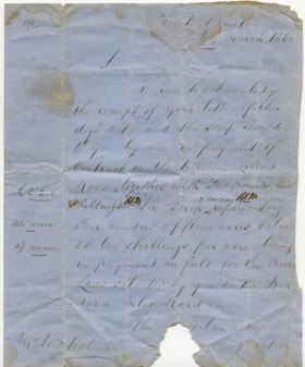
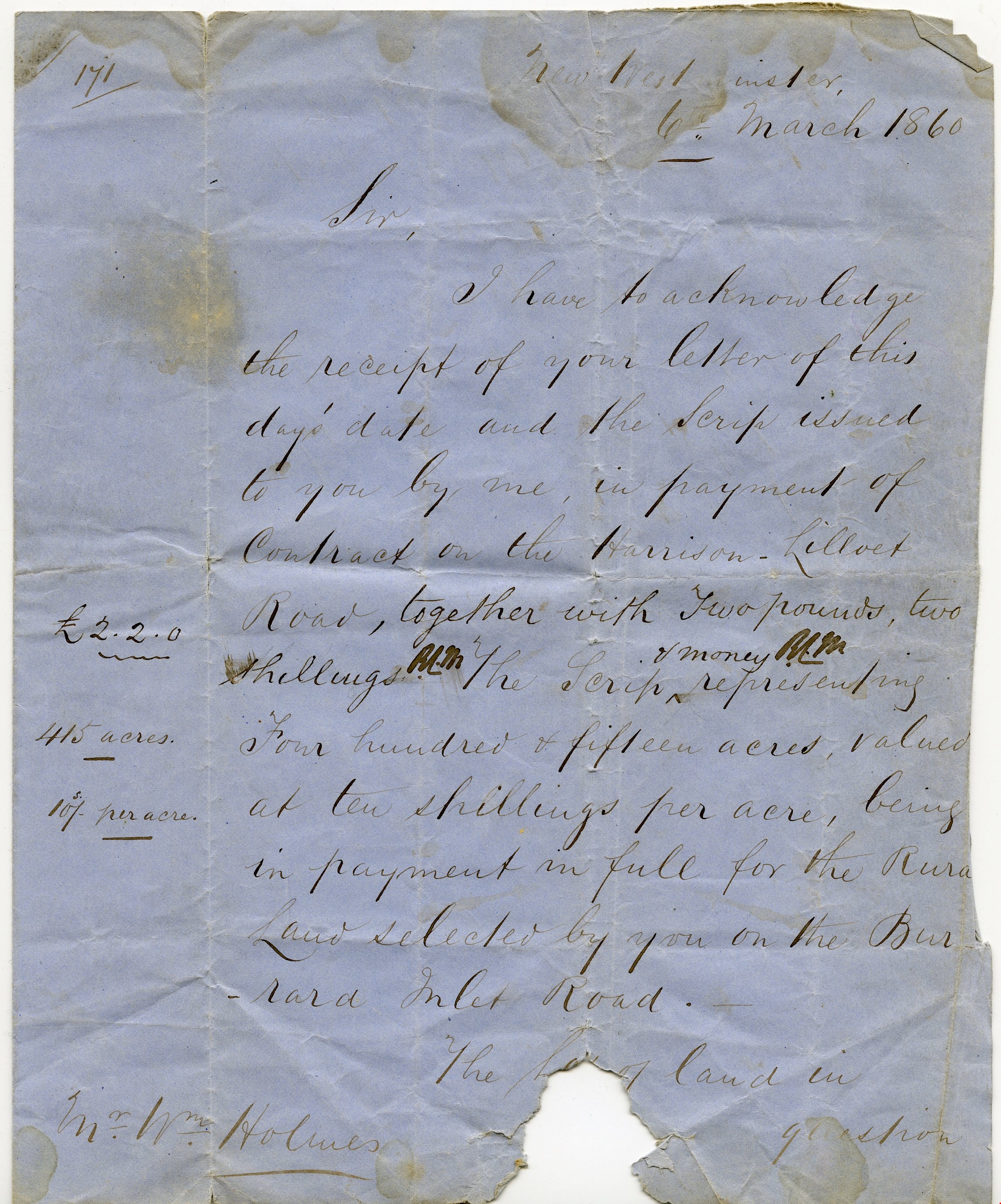
Letter re payment of Lot No. 1, Group 1, New Westminster District
https://search.heritageburnaby.ca/link/museumdescription10404
- Repository
- Burnaby Village Museum
- Date
- 6 Mar. 1860
- Collection/Fonds
- William Holmes fonds
- Description Level
- Item
- Physical Description
- 1 p. textual record ; folded
- Scope and Content
- Item consists of a handwritten letter on blue paper dated "6th March 1860". The letter is addressed to Mr. Wm. Holmes from Colonel Moody regarding payment of a contract on Harrison Lilloet Road and two pounds two shillings scrip payment for land on Burrard Inlet Road..."Lot No. 1, Group 1, Rural La…
- Repository
- Burnaby Village Museum
- Collection/Fonds
- William Holmes fonds
- Description Level
- Item
- Physical Description
- 1 p. textual record ; folded
- Scope and Content
- Item consists of a handwritten letter on blue paper dated "6th March 1860". The letter is addressed to Mr. Wm. Holmes from Colonel Moody regarding payment of a contract on Harrison Lilloet Road and two pounds two shillings scrip payment for land on Burrard Inlet Road..."Lot No. 1, Group 1, Rural Land, New Westminster District..."
- Accession Code
- BV997.50.3
- Access Restriction
- No restrictions
- Reproduction Restriction
- No known restrictions
- Date
- 6 Mar. 1860
- Media Type
- Textual Record
- Scan Resolution
- 300
- Scan Date
- 06-May-2019
- Notes
- Title based on contents of item
Images

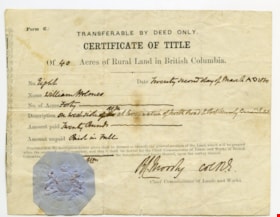
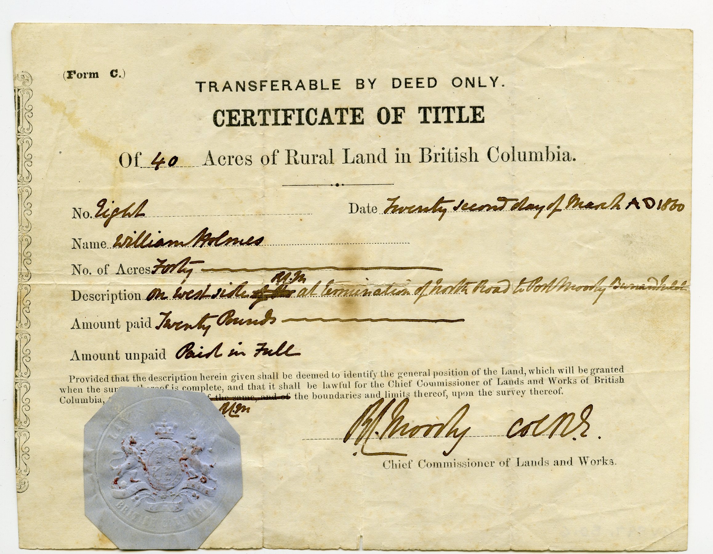
Certificate of Title
https://search.heritageburnaby.ca/link/museumdescription10408
- Repository
- Burnaby Village Museum
- Date
- 22 Mar. 1860
- Collection/Fonds
- William Holmes fonds
- Description Level
- Item
- Physical Description
- 1 certificate
- Scope and Content
- Item consists of "Certificate of Title" to Mr. William Holmes for land in Burnaby/NE Westminster; "40 Acres", "Twenty Second Day of March AD 1860". Description reads: "On West Side at termination of North Road to Port Moody Burrard Inlet". The blue Provincial seal is affixed to the certificate and…
- Repository
- Burnaby Village Museum
- Collection/Fonds
- William Holmes fonds
- Description Level
- Item
- Physical Description
- 1 certificate
- Scope and Content
- Item consists of "Certificate of Title" to Mr. William Holmes for land in Burnaby/NE Westminster; "40 Acres", "Twenty Second Day of March AD 1860". Description reads: "On West Side at termination of North Road to Port Moody Burrard Inlet". The blue Provincial seal is affixed to the certificate and it is signed by R.C. Moody, "Chief Commissioner of Lands and Works".
- Accession Code
- BV997.50.6
- Access Restriction
- No restrictions
- Reproduction Restriction
- No known restrictions
- Date
- 22 Mar. 1860
- Media Type
- Textual Record
- Scan Resolution
- 300
- Scan Date
- 06-May-2019
- Notes
- Title based on contents of item
Images
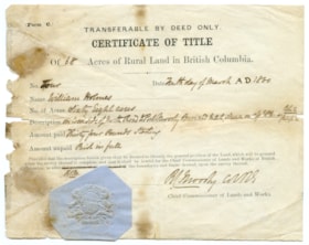
Certificate of Title
https://search.heritageburnaby.ca/link/museumdescription10409
- Repository
- Burnaby Village Museum
- Date
- 22 Mar. 1860
- Collection/Fonds
- William Holmes fonds
- Description Level
- Item
- Physical Description
- 1 certificate
- Scope and Content
- Item consists of "Certificate of Title" to Mr. William Holmes for land in Burnaby/NE Westminster; "68 Acres", "Tenth Day of March AD 1860". Description reads: "On West Side of North Road to Port Moody Burrard Inlet, shown on the [?] Plan as Lots 2 / Group 1". The blue Provincial seal is affixed to…
- Repository
- Burnaby Village Museum
- Collection/Fonds
- William Holmes fonds
- Description Level
- Item
- Physical Description
- 1 certificate
- Scope and Content
- Item consists of "Certificate of Title" to Mr. William Holmes for land in Burnaby/NE Westminster; "68 Acres", "Tenth Day of March AD 1860". Description reads: "On West Side of North Road to Port Moody Burrard Inlet, shown on the [?] Plan as Lots 2 / Group 1". The blue Provincial seal is affixed to the certificate and it is signed by R.C. Moody "Chief Commissioner of Lands and Works".
- Accession Code
- BV997.50.7
- Access Restriction
- No restrictions
- Reproduction Restriction
- No known restrictions
- Date
- 22 Mar. 1860
- Media Type
- Textual Record
- Scan Resolution
- 300
- Scan Date
- 06-May-2019
- Notes
- Title based on contents of item
Images
Chambers's encyclopaedia : a dictionary of universal knowledge for the people illustrated with maps and numerous wood engravings, vol. i
https://search.heritageburnaby.ca/link/museumlibrary77
- Repository
- Burnaby Village Museum
- Collection
- Special Collection
- Material Type
- Book
- Accession Code
- HV971.15.51
- Call Number
- 032 CHA v.1
- Place of Publication
- London
- Publisher
- W. and R. Chambers
- Publication Date
- 1860
- Printer
- W. and R. Chambers
- Physical Description
- 819 p. : ill., maps; 26 cm.
- Library Subject (LOC)
- Encyclopedias and dictionaries
- Object History
- From the August 3, 1971 acquisition record: "This set of Encyclopedia was given to my paternal Grandparents on their wedding day in 1876, in London, England. They were given to my father (L.W. Taverner) upon the day of his father in 1897 and he brought them to Canada when he emigrated here in 1904. I can recall they many times they were used as "reference" in my early childhood not only by our family, but by neighbours and friends in settling 'friendly' arguments."
- Notes
- volume 1 of 10.
magazine
https://search.heritageburnaby.ca/link/museumartifact27434
- Repository
- Burnaby Village Museum
- Accession Code
- HV974.113.12
- Description
- The Canadian United Presbyterian Magazine - Magazine -- [1861]. Vol VIII, June No.6. Underneath the title is a small drawing of the Holy Bible with flowers and a globe beside it. There is a scroll that goes along the bottom of the drawing that says "THE DESERT SHALL REJOICE". The magazine was printed in Toronto by Lovell & Gibson. The cover is blue with black print. On the back cover there are ads for other publications
- Category
- 08. Communication Artifacts
- Classification
- Documentary Artifacts - - Other Documents
- Object Term
- Serial
- Maker
- Lovell & Gibson
- Country Made
- Canada
- Province Made
- Ontario
- Site/City Made
- Toronto
- Title
- The Canadian United Presbyterian Magazine
- Publication Date
- 1861
Images
![Survey and Subdivision plans in New Westminster District Group 1 – Burnaby
, [1861]-[1910] thumbnail](/media/hpo/_Data/_BVM_Cartographic_Material/1977/1977_0093_0019a_001.jpg?width=280)
Survey and Subdivision plans in New Westminster District Group 1 – Burnaby
https://search.heritageburnaby.ca/link/museumdescription6988
- Repository
- Burnaby Village Museum
- Date
- [1861]-[1910]
- Collection/Fonds
- Burnaby Village Museum Map collection
- Description Level
- File
- Physical Description
- 14 plans : 3 plans : black ink on paper hand col. + 7 plans : black ink on paper + 4 plans : graphite on paper mounted on 2 sides of cardboard 76 x 102 cm
- Scope and Content
- Item consists of a large board of four New Westminster District Gp 1 - subdivision plans mounted on one side and ten New Westminster District Gp 1 - subdivision plans mounted on the other side. Side A: 1. "Plan /of / Lots 166A, 166 and 167 /, Gr.1, N.W.D. / Showing Misconstructed Roads in Gree…
- Repository
- Burnaby Village Museum
- Collection/Fonds
- Burnaby Village Museum Map collection
- Description Level
- File
- Physical Description
- 14 plans : 3 plans : black ink on paper hand col. + 7 plans : black ink on paper + 4 plans : graphite on paper mounted on 2 sides of cardboard 76 x 102 cm
- Material Details
- Scales [between 1:2376 and 1:7920]
- Index number on edge of board reads: "19"
- Scope and Content
- Item consists of a large board of four New Westminster District Gp 1 - subdivision plans mounted on one side and ten New Westminster District Gp 1 - subdivision plans mounted on the other side. Side A: 1. "Plan /of / Lots 166A, 166 and 167 /, Gr.1, N.W.D. / Showing Misconstructed Roads in Green / 5 chs = 1 in.". (plan is drawn in black ink and hand coloured in red, green and orange ink). A section in the centre of the plan is coloured in red ink and identified as "C.S. Richmond" running from the North Arm of Fraser River to Wiggins Road and divided by "New Wiggins Rd. (as gazetted)" (coloured in orange ink) and two"Constructed Road(s)" (coloured in green ink). Plan is initialed by: "RB" [sic] (in blue pencil crayon) 2. Plan of / Subdivision of / Lot 166 / Group One / New Westminster District / Scale 4 chs = 1 in. / Map No 524". Plan is drawn in graphite and signed by "Surrig [sic] Welhams [sic] / P.L.S." Plan is initialed by: "RB" [sic] (in blue pencil crayon) 3. Plan of "Survey / of Highway / For / Burnaby Council / in / Lots 13 _14 / Group One / Scale 4 chs = 1 in." Signed by "Albert J. Hill, P.L.S." Caribou Street and Caribou Road run through the centre of the plan. Plan is stamped: "Albert J. Hill, Civil Engineer / and / Provincial Land Surveyor, / New Westminster, / B.C.". Plan is initialed by: "RB" [sic] (in blue pencil crayon) 4. A Plan of Lots 166A, 166 and 167, Group One, New Westminster District (drawn in graphite). A section in the centre of the plan is identified as "C.S. Richmond" running from the North Arm of Fraser River and divided by "New Wiggins Rd. (as gazetted)" and two "Constructed Road(s)". Plan is initialed by: "RB" [sic] (in blue pencil crayon) Side B: 1. Small plan drawn in black ink (no title) identifying lots north of the "North Arm" of the Fraser River. Lots identified include: Lot 99, Lot 98, Lot 157, Lot 158, Lot 163, Lot 162, Lot 159, Lot 163, Lot 162, Lot 165, Lot 166A, Lot 155B, Lot 155A and Lot 159. "Scale 40 chains to one inch" . Plan is initialed by: "RB" [sic] (in blue pencil crayon) (Geographic location: Burnaby) 2. Small plan drawn in black ink (no title) identifying lots north of the North Arm of the Fraser River as "Lots 155, 155A, 155B, 155C, 162, 163, 164, 165, 166A and 167". Plan is initialed by: "RB" [sic] (in blue pencil crayon) (Geographic location: Burnaby) 3. Small plan drawn in black ink (no title) which identifies "Lot 151 / Reserve/ for / Race Course"; "Reserve / 64 A / L. 152 G.1"; and other Lots: 32, 33, 34, 35, 36, 38, 39. The plan is signed "Surveyor G.Turn [sic] July / 61 / from Vol 40 R.L. notes [sic]" Plan is stamped: "Albert J. Hill, Civil Engineer / and / Provincial Land Surveyor, / New Westminster, / B.C." Plan is initialed by: "RB" [sic] (in blue pencil crayon) (Geographic location: Burnaby) 4. Small plan drawn in black in with faded red colouring on centre lot identified as "Lot 34" running north from "Vancouver Road" . Plan is stamped: "Albert J. Hill, Civil Engineer / and / Provincial Land Surveyor, / New Westminster, / B.C." Plan is initialed by: "RB" [sic] (in blue pencil crayon) (Geographic location: Burnaby) 5. Plan drawn in graphite and identified as "Lot 98, Gr.1," along with the intials "RB" [sic] (both are handwritten in blue crayon pencil on top of plan) The B.C.E.Railway is identified running through the plan along with Jubilee Road and Royal Oak Road. The plan is signed with the name "Wm. Murray" and the Plan is stamped: "Albert J. Hill, Civil Engineer / and / Provincial Land Surveyor, / New Westminster, / B.C.". (Geographic location: Burnaby) 6. Plan drawn in graphite identified as "Port Lot 13, Gr.1" along with the intials "RB" [sic] (both are handwritten in blue crayon pencil on top of plan) Plan is stamped: "Albert J. Hill, Civil Engineer / and / Provincial Land Surveyor, / New Westminster, / B.C.". (Geographic location: Burnaby) 7.Plan drawn in black ink and identified as "Lot 98 G.1" along with the intials "RB" [sic] (both are handwritten in blue crayon pencil on top of plan). A "Road Reservation" is identified running north between "Electric Tramway" and connecting with "Royal Oak Road". Plan is stamped: "Albert J. Hill, Civil Engineer / and / Provincial Land Surveyor, / New Westminster, / B.C." (Geographic location: Burnaby) 8. Plan drawn in black ink and divided into two sections, the upper plan is identified as "Portion / Lots 100 / area / 101, Gr.1" and the lower plan is identified as "Portion L. 3 G. 1" along with the intials "RB" [sic] (these identifiers are handwritten in blue crayon pencil on top of the plan). Portions of Lot 100 and Lot 101 are each divided into 6 sections and the Portion of Lot 3 plan is divided into 24 sections. The plan includes a note in black ink that reads: " Received from Wm Fromme [sic] / from Wm. Trapp / Nov. 28, 1895 / A. J. T...[sic]". (Geographic location: Burnaby) 9. Plan drawn in black ink (no title) identifying soil, buildings and geographic features in southern Burnaby. The plan is bordered by "New Westminster City" (Tenth Avenue and DL 172) to the south east and DL 173 to the south, DL 158 to the west and the B.C.E. Tramway to the north. Plan includes District Lots: 155A, 158, 159, 171, 160, 53 and 95 and identifies soil, marshland and ravines throughout. Plan identifies the following features: a "Team Road" running through Lots 158 and 159 along with "Fair Orchard Soil / Even Surface Throughout / No Ravines", "Gravel and Shingle" (bottom of Lot 158), "North Arm Road" crossing "Byrne Road" and connecting with "Power House Road" which runs north to connect with "Highland Park Station" and the B.C.E. Tramway, "Power Ho" in the northeast corner of DL 160, a "Brook" connected with a "Deep Ravine" running between DL 53, DL 95 and DL 160 along with "Good Soil" and "Fair Orchard Soil" identified nearby in DL 95. Scale is identified as "10 chs = 1 in." Plan is stamped: "Albert J. Hill, Civil Engineer / and / Provincial Land Surveyor, / New Westminster, / B.C." Plan is initialed by: "RB" [sic] (in blue pencil crayon) (Geographic location: Burnaby) 10. Plan drawn in black ink (no title) with Burnaby Lake and Deer Lake at the centre. The plan is bordered by the following District Lots identified as: 117, 118 and 68 to the west, Lots 80, 79 and 85 to the southwest, Lots 11, 13, and 1 (City of New Westminster) to the south east, the North Road boundary to the east and Lots 8, 56, 57, 59, and 136 to the North. The lower right hand corner of the plan has a small inset which reads: "Burnaby Lake" and "Page 19 R.B. Notes". Plan is initialed by: "RB" [sic] (in blue pencil crayon) (Geographic location: Burnaby)
- Creator
- Hill, Albert James
- Accession Code
- HV977.93.19
- Access Restriction
- No restrictions
- Reproduction Restriction
- No known restrictions
- Date
- [1861]-[1910]
- Media Type
- Cartographic Material
- Scan Resolution
- 300
- Scale
- 72
- Notes
- Title based on contents of file
- Scale is measured in chains. (One chain equals 792 inches)
- The term "Lot" can also refer to a "District Lot”
- Some plans are stamped: "Albert J. Hill, Civil Engineer / and / Provincial Land Surveyor, / New Westminster, / B.C." and intialed: "RB" [sic]
Images
![Survey and Subdivision plans in New Westminster District Group 1 – Burnaby
, [1861]-[1910] thumbnail](/media/hpo/_Data/_BVM_Cartographic_Material/1977/1977_0093_0019a_001.jpg)

Certificate of Title
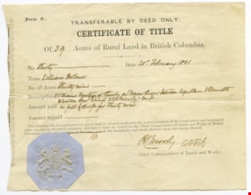
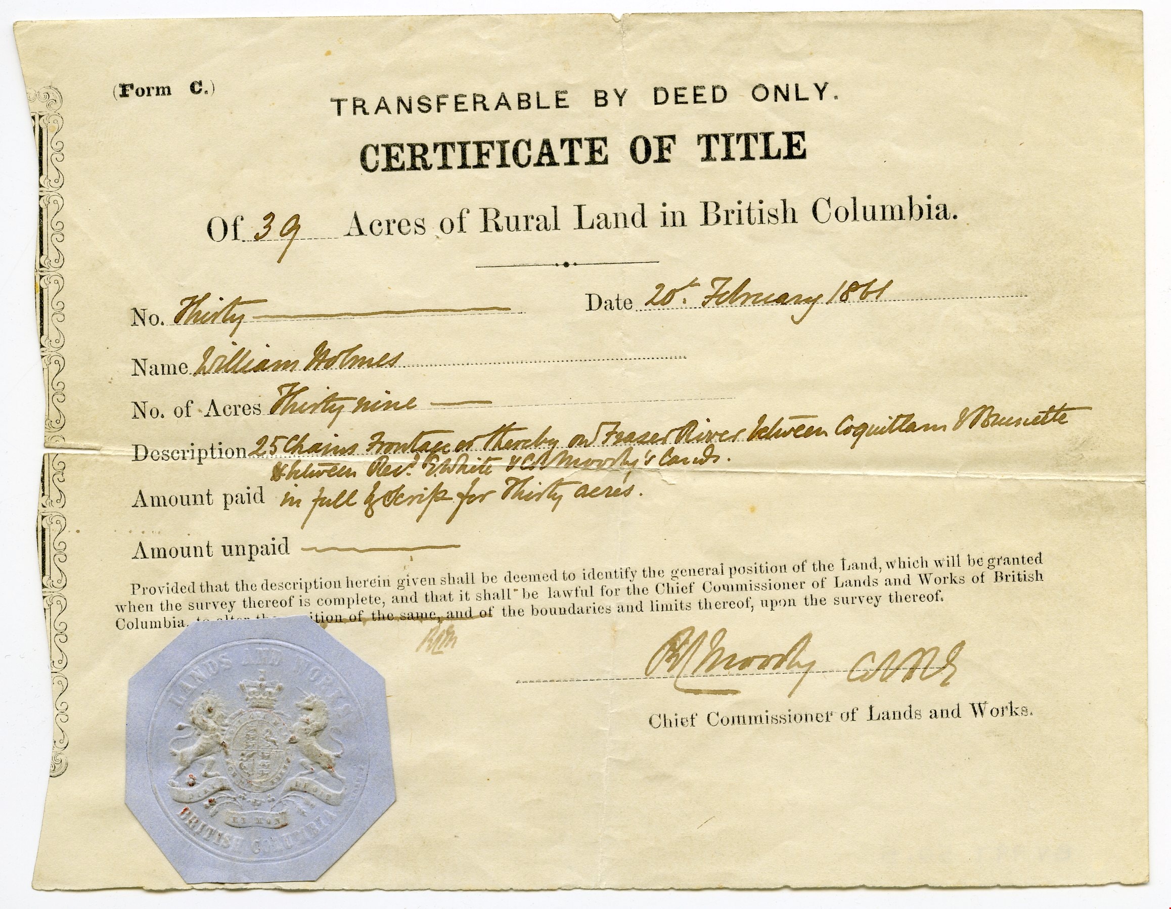
https://search.heritageburnaby.ca/link/museumdescription10407
- Repository
- Burnaby Village Museum
- Date
- 20 Feb. 1861
- Collection/Fonds
- William Holmes fonds
- Description Level
- Item
- Physical Description
- 1 certificate
- Scope and Content
- Item consists of "Certificate of Title" to Mr. William Holmes for land in Burnaby/NE Westminster; "39 Acres", "20th February 1861". "Description" reads: "25 Chains Frontage on thereby on Fraser River between Coquitlam & Brunette / between Rev. E. White & Col. Moody's [?]". The blue Provincial seal…
- Repository
- Burnaby Village Museum
- Collection/Fonds
- William Holmes fonds
- Description Level
- Item
- Physical Description
- 1 certificate
- Scope and Content
- Item consists of "Certificate of Title" to Mr. William Holmes for land in Burnaby/NE Westminster; "39 Acres", "20th February 1861". "Description" reads: "25 Chains Frontage on thereby on Fraser River between Coquitlam & Brunette / between Rev. E. White & Col. Moody's [?]". The blue Provincial seal is affixed to the certificate and it is signed by R.C. Moody, "Chief Commissioner of Lands and Works".
- Accession Code
- BV997.50.5
- Access Restriction
- No restrictions
- Reproduction Restriction
- No known restrictions
- Date
- 20 Feb. 1861
- Media Type
- Textual Record
- Scan Resolution
- 300
- Scan Date
- 06-May-2019
- Notes
- Title based on contents of item
Images
Chambers's encyclopaedia : a dictionary of universal knowledge for the people illustrated with maps and numerous wood engravings, vol. ii
https://search.heritageburnaby.ca/link/museumlibrary78
- Repository
- Burnaby Village Museum
- Collection
- Special Collection
- Material Type
- Book
- Accession Code
- HV971.15.52
- Call Number
- 032 CHA v.2
- Place of Publication
- London
- Publisher
- W. and R. Chambers
- Publication Date
- 1861
- Printer
- W. and R. Chambers
- Physical Description
- 828 p. : ill., maps ; 26 cm.
- Library Subject (LOC)
- Encyclopedias and dictionaries
- Object History
- From the August 3, 1971 acquisition record: "This set of Encyclopedia was given to my paternal Grandparents on their wedding day in 1876, in London, England. They were given to my father (L.W. Taverner) upon the day of his father in 1897 and he brought them to Canada when he emigrated here in 1904. I can recall they many times they were used as "reference" in my early childhood not only by our family, but by neighbours and friends in settling 'friendly' arguments."
- Notes
- volume 2 of 10.
Ten quadrilles for the pianoforte
https://search.heritageburnaby.ca/link/museumlibrary605
- Repository
- Burnaby Village Museum
- Author
- Albert, Charles d' 1809-1886
- Publication Date
- 1861
- Call Number
- 780 DAL
- Repository
- Burnaby Village Museum
- Collection
- Special Collection
- Material Type
- Book
- Accession Code
- BV985.209.1
- Call Number
- 780 DAL
- Author
- Albert, Charles d' 1809-1886
- Contributor
- Rimbault, Edward F. (Edward Francis), 1816-1876
- Place of Publication
- London
- Publisher
- Chappell & Co.
- Publication Date
- 1861
- Series
- Chappell's musical magazine
- Physical Description
- Rimbault, Edward F.
- Inscription
- "Beatrice Tate" [handwritten on page opposing front pastedown in black ink]
- Library Subject (LOC)
- Music
- Notes
- Author's full name and dates Charles Louis Napoléon d' Albert, 1809-1886.
![Survey and Subdivision plans in New Westminster District Group 1 – Burnaby, Port Moody, [1862-1908] thumbnail](/media/hpo/_Data/_BVM_Cartographic_Material/1977/1977_0093_0026a_001.jpg?width=280)
Survey and Subdivision plans in New Westminster District Group 1 – Burnaby, Port Moody
https://search.heritageburnaby.ca/link/museumdescription6995
- Repository
- Burnaby Village Museum
- Date
- [1862-1908]
- Collection/Fonds
- Burnaby Village Museum Map collection
- Description Level
- File
- Physical Description
- 9 plans : 6 plans : black ink on paper ; 57 x 36.5 cm or smaller + 1 plan : black ink and grahite on paper ; 46.5 x 49 cm + 1 plan : blueprint on paper ; 15.5 x 19.5 cm + cm + 1 plan : graphite on paper ; 25 x 17 cm ; mounted on both sides of board 76 x 102 cm
- Scope and Content
- Item consists of a large board of four New Westminster District subdivision plans mounted on one side and five New Westminster District subdivision plans mounted on the other side. Side A: 1. "Plan / of Subdivision / of a Portion / of / Lot 87 / Group One / New Westminster District / Scale 4 chs…
- Repository
- Burnaby Village Museum
- Collection/Fonds
- Burnaby Village Museum Map collection
- Description Level
- File
- Physical Description
- 9 plans : 6 plans : black ink on paper ; 57 x 36.5 cm or smaller + 1 plan : black ink and grahite on paper ; 46.5 x 49 cm + 1 plan : blueprint on paper ; 15.5 x 19.5 cm + cm + 1 plan : graphite on paper ; 25 x 17 cm ; mounted on both sides of board 76 x 102 cm
- Material Details
- Scales [between 1:792 and 1:3600]
- Index number on edge of board reads: "26"
- Scope and Content
- Item consists of a large board of four New Westminster District subdivision plans mounted on one side and five New Westminster District subdivision plans mounted on the other side. Side A: 1. "Plan / of Subdivision / of a Portion / of / Lot 87 / Group One / New Westminster District / Scale 4 chs = 1 in". Plan is stamped: "Albert J. Hill, Civil Engineer / and / Provincial Land Surveyor, / New Westminster, / B.C." and intialed by: "RB" [sic] (in blue pencil crayon). Names two of the subdivisons of District Lot 87 are identified as, "L.E. Sprott" and "John Ledger". (Geographic location: Burnaby) 2. "Plan of Subdivision / of / Portions of / Lot 136, 131 and Lots 44 and 78 Gr.1 / New Westminster District / Scale 300 ft = 1 inch". Annotation above title reads: "No. 901 / Deposited in Land Registry Office / New Westminster / Aug. 19th 1905 / Charles S. Keith D. Reg." Annotations and signatures at bottom of plan read: "I, William Nelson Draper, / W.H.R. Collister / Charles E. Perkins / E.B. Morgan / make / Surveys / correct / representation / upon / the / Land Registry Act / (sgd) W.N. Draper, P.L.S.". Plan includes a handwritten title: "Lots 136, 131, 44 & 78" and is initialed: "RB" [sic] (in blue pencil crayon) (Geographic location: Burnaby) 3. "Survey / of / a Portion / of / Lot 95, Gr.1 / Scale 1 ch = 1in." Plan is stamped: "Albert J. Hill, Civil Engineer / and / Provincial Land Surveyor, / New Westminster, / B.C." and is initialed : "RB" [sic] (in blue pencil crayon) (Geographic location: Burnaby) 4. Blueprint plan of "Lot 396. Group One." with Scale : 3 chs = 1 in. A two acre portion of District Lot 396 is filled in with red ink." Plan is signed by "Albert J. Hill / B.C.L.S." (Geographic location: Port Moody) Side B: 1. Plan titled "District Lot 92 / Burnaby / Municipality / for sale by / Mahon / McFarland & / Mahon Ltd. / Vancouver, B.C. / Scale : 4 chains to one inch". District Lot 92 is subdivided into 161 lots and identifies roads: Norwich Road, Pole Line Road, Oakland Road, Stanley Road, Burford Road, Dalhousie Road, Brantford Road, Colborne Road, Roberts Road, Vancouver & Westminster Road, B.C. Electric Railway, Gilley Stn. and Burnaby (Power House). The bottom of the plan reads: "G.S. Dawson, P.LS. Vancouver, B.C." (Geographic location: Burnaby) 2. "Plan / of Subdivision / of a Portion / of / Lot 29 / Group 1 / New Westminster District / Scale 2 chs = 1 in". Plan is stamped: "Albert J. Hill, Civil Engineer / and / Provincial Land Surveyor, / New Westminster, / B.C." and is initialed by: "RB" [sic] (in blue pencil crayon) (Geographic location: Burnaby) 3. Small handrawn plan (no title) identifying "Lot 84 / Hydes, Claim" at the centre surrounded by lots and features identified as: "Lot 85", "Lot 93", "Lot 94", "Lot 32", "Lot 82", "Lot 83", "Lot 79", "swamp" and a "Small Lake" (Burnaby Lake). Identifying marks in the right corner of the plan read: "Page 13 / Surveyed by G. Turner / May 62". Plan also includes surveyor's bearing measurements and trails to "Small Lake" (Burnaby Lake). (Geographic location: Burnaby) 4. Untitled plan showing District Lots west of North Road and north of Burnaby Lake including: Lots 2, 4, 6, 8, 15, 10, 56, 148, 57, 58, 40. and Lots 3, 5, 7 east of North Road (Coquitlam). Lots in Burnaby are identifed for timber including: "Heavily Timbered" (Lot 57), " "Some Fir and Cedar" (Lot 40), "Splendid Fir and Cedar" (Lot 143), "Heavy Fir etc" (Lots 143 and 148), " "Fine Cedar" (Lot 15), "Rough Light Timber" (Lot 56). Other features identified at the lower portion of the plan include "Burnaby Lake" and "Brunette River". (Geographic location: Burnaby) 5. Untitled plan drawn in graphite showing sections of District Lot 85 south of Burnaby Lake and north of Hazsard Road. Plan is signed: "Albert J. Hill / B.C.L.S." and dated "12/26/08". Plan is initialed by: "RB" [sic] (in blue pencil crayon) (Geographic location: Burnaby)
- Publisher
- Mahon, McFarland & Mahon Ltd
- Accession Code
- HV977.93.26
- Access Restriction
- No restrictions
- Reproduction Restriction
- No known restrictions
- Date
- [1862-1908]
- Media Type
- Cartographic Material
- Historic Neighbourhood
- Burnaby Lake (Historic Neighbourhood)
- Burquitlam (Historic Neighbourhood)
- Planning Study Area
- Burnaby Lake Area
- Scan Resolution
- 300
- Scale
- 72
- Notes
- Title based on contents of file
- Scale is measured in chains and feet. (One chain equals 792 inches)
- The term "Lot" can also refer to a "District Lot”
Images
![Survey and Subdivision plans in New Westminster District Group 1 – Burnaby, Port Moody, [1862-1908] thumbnail](/media/hpo/_Data/_BVM_Cartographic_Material/1977/1977_0093_0026a_001.jpg)


Chambers's encyclopaedia : a dictionary of universal knowledge for the people illustrated with maps and numerous wood engravings, vol. iii
https://search.heritageburnaby.ca/link/museumlibrary79
- Repository
- Burnaby Village Museum
- Collection
- Special Collection
- Material Type
- Book
- Accession Code
- HV971.15.53
- Call Number
- 032 CHA v.3
- Place of Publication
- London
- Publisher
- W. and R. Chambers
- Publication Date
- 1862
- Printer
- W. and R. Chambers
- Physical Description
- 827 p. : ill., maps ; 26 cm.
- Library Subject (LOC)
- Encyclopedias and dictionaries
- Object History
- From the August 3, 1971 acquisition record: "This set of Encyclopedia was given to my paternal Grandparents on their wedding day in 1876, in London, England. They were given to my father (L.W. Taverner) upon the day of his father in 1897 and he brought them to Canada when he emigrated here in 1904. I can recall they many times they were used as "reference" in my early childhood not only by our family, but by neighbours and friends in settling 'friendly' arguments."
- Notes
- volume 3 of 10.
Chambers's encyclopaedia : a dictionary of universal knowledge for the people illustrated with maps and numerous wood engravings, vol. iv
https://search.heritageburnaby.ca/link/museumlibrary80
- Repository
- Burnaby Village Museum
- Collection
- Special Collection
- Material Type
- Book
- Accession Code
- HV971.15.54
- Call Number
- 032 CHA v.4
- Place of Publication
- London
- Publisher
- W. and R. Chambers
- Publication Date
- 1862
- Printer
- W. and R. Chambers
- Physical Description
- 828 p. : ill., maps ; 26 cm.
- Library Subject (LOC)
- Encyclopedias and dictionaries
- Object History
- From the August 3, 1971 acquisition record: "This set of Encyclopedia was given to my paternal Grandparents on their wedding day in 1876, in London, England. They were given to my father (L.W. Taverner) upon the day of his father in 1897 and he brought them to Canada when he emigrated here in 1904. I can recall they many times they were used as "reference" in my early childhood not only by our family, but by neighbours and friends in settling 'friendly' arguments."
- Notes
- volume 4 of 10.
Key to Gasc's First and Second French books
https://search.heritageburnaby.ca/link/museumlibrary1497
- Repository
- Burnaby Village Museum
- Author
- Gasc, Ferdinand E. A.
- Publication Date
- 1862
- Call Number
- 448.34 GAS
- Repository
- Burnaby Village Museum
- Collection
- Special Collection
- Material Type
- Book
- Accession Code
- BV985.3717.1
- Call Number
- 448.34 GAS
- Author
- Gasc, Ferdinand E. A.
- Place of Publication
- London
- Publisher
- Bell and Daldy
- Publication Date
- 1862
- Printer
- R. Clay, Son and Taylor
- Physical Description
- 54 p, ; 15 cm.
- Library Subject (LOC)
- French language--Problems, exercises, etc.
- French language--Grammar
- Notes
- Provides answers to exercises found in "Gasc's First French Book" and "Gasc's Second French Book".
The way to life : sermons
https://search.heritageburnaby.ca/link/museumlibrary1595
- Repository
- Burnaby Village Museum
- Author
- Guthrie, Thomas, 1803-1873
- Publication Date
- 1862
- Call Number
- 252.052 GUT
- Repository
- Burnaby Village Museum
- Collection
- Special Collection
- Material Type
- Book
- Accession Code
- BV985.3914.1
- Call Number
- 252.052 GUT
- Author
- Guthrie, Thomas, 1803-1873
- Place of Publication
- Edinburgh
- Publisher
- Adam and Charles Black
- Publication Date
- 1862
- Printer
- R. and B. Clark
- Physical Description
- viii, 402 p. ; 18 cm.
- Inscription
- "[Jnth] Henry D Glowin' kind regards" -- handwritten in pencil on first page.
- Library Subject (LOC)
- Presbyterian Church
- Sermons, English
- Notes
- Includes index.