Narrow Results By
Creator
- Bartel, Mario 23
- British Columbia Underwriters' Association 3
- Burnaby Village Museum 1
- Burnett, Geoffrey K. 3
- Burnett & McGugan, Engineers and Surveyors 1
- Cheung, Nakita 2
- Cooksley, William Thomas 3
- Disney, John Harold "Jack" 4
- Finley, Martha, 1828-1909 9
- Garden, Hermon and Burwell 1
- Hodge, Craig 1
- Jones, Charles Spurgeon "Chuck" 1

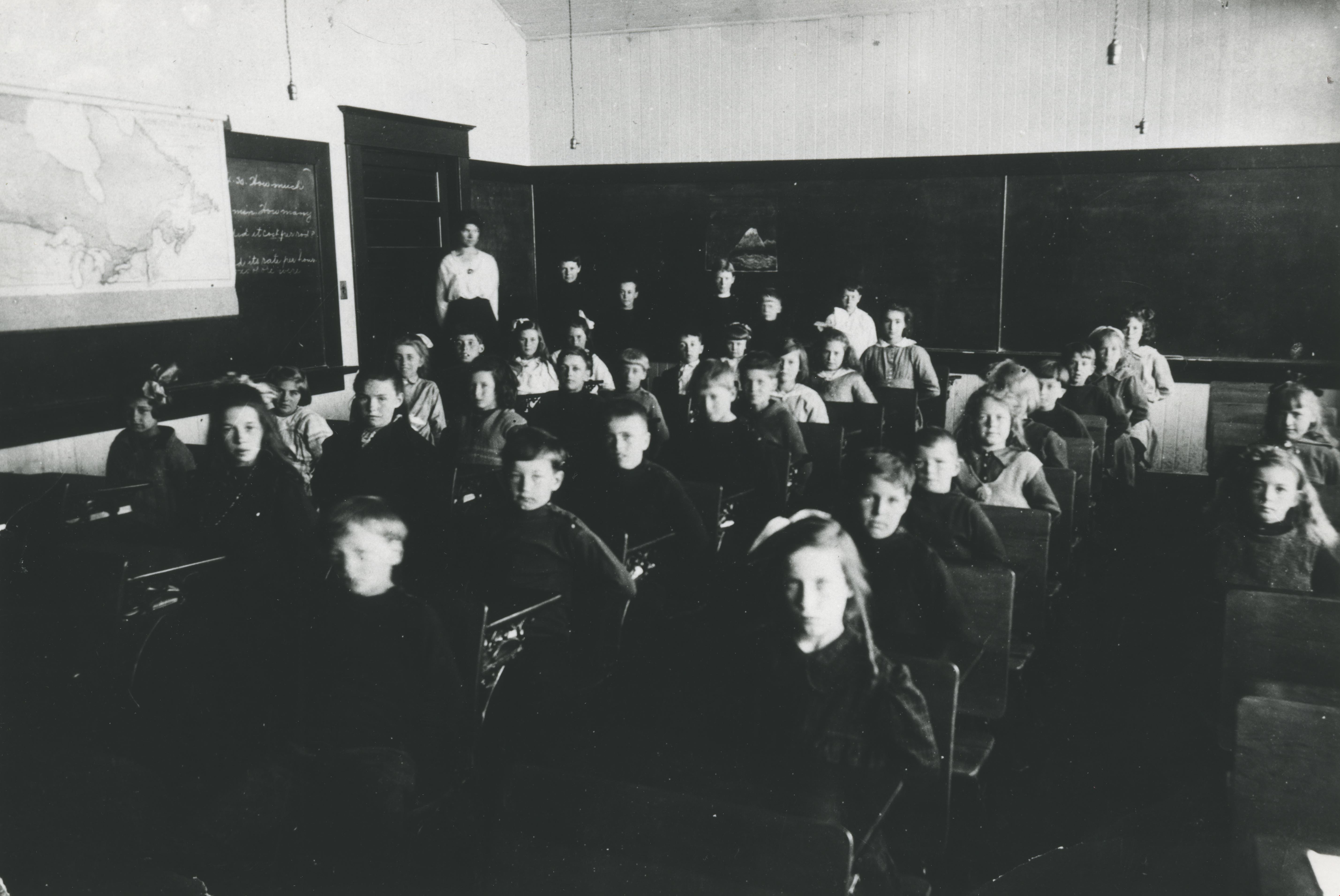
Second Street School Class
https://search.heritageburnaby.ca/link/archivedescription34805
- Repository
- City of Burnaby Archives
- Date
- 1920 (date of original), copied 1985
- Collection/Fonds
- Burnaby Historical Society fonds
- Description Level
- Item
- Physical Description
- 1 photograph : b&w ; 20.2 x 25.3 cm print
- Scope and Content
- Photograph of a Second Street School classroom. The students are seated at desks, and the teacher is standing behind them beside a chalkboard and a map.
- Repository
- City of Burnaby Archives
- Date
- 1920 (date of original), copied 1985
- Collection/Fonds
- Burnaby Historical Society fonds
- Subseries
- Ethel Derrick subseries
- Physical Description
- 1 photograph : b&w ; 20.2 x 25.3 cm print
- Description Level
- Item
- Record No.
- 136-001
- Access Restriction
- No restrictions
- Reproduction Restriction
- No known restrictions
- Accession Number
- BHS1985-05
- Scope and Content
- Photograph of a Second Street School classroom. The students are seated at desks, and the teacher is standing behind them beside a chalkboard and a map.
- Names
- Second Street School
- Media Type
- Photograph
- Notes
- Title based on contents of photograph
- Geographic Access
- 2nd Street
- Street Address
- 7502 2nd Street
- Historic Neighbourhood
- East Burnaby (Historic Neighbourhood)
- Planning Study Area
- Second Street Area
Images
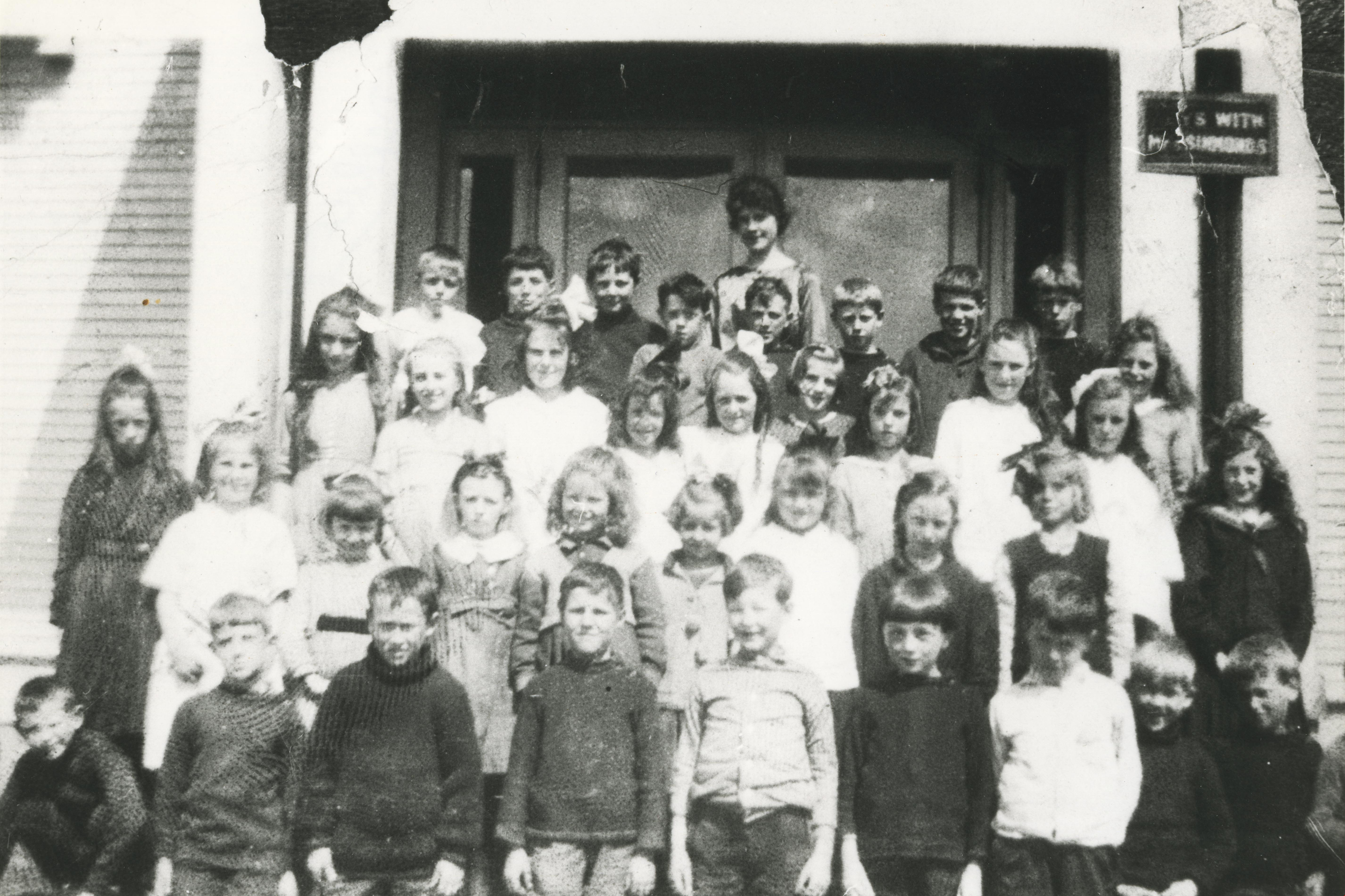
Second Street School Class
https://search.heritageburnaby.ca/link/archivedescription34806
- Repository
- City of Burnaby Archives
- Date
- 1920 (date of original), copied 1985
- Collection/Fonds
- Burnaby Historical Society fonds
- Description Level
- Item
- Physical Description
- 1 photograph : b&w ; 20.2 x 25.3 cm print
- Scope and Content
- Photograph of a Second Street School class taken outside of the school. Back row, left to right: Kenneth Wilson, Victor Spong, Gordon Ramsey, Murdoch McLeod, Keith Waite, Frank Trewern, Herbert Spong, and Charlie Trewern. Next row, left to right: Mina Fraser, Florence Wilson, Ethel Beamish, Eliza…
- Repository
- City of Burnaby Archives
- Date
- 1920 (date of original), copied 1985
- Collection/Fonds
- Burnaby Historical Society fonds
- Subseries
- Ethel Derrick subseries
- Physical Description
- 1 photograph : b&w ; 20.2 x 25.3 cm print
- Description Level
- Item
- Record No.
- 136-002
- Access Restriction
- No restrictions
- Reproduction Restriction
- No known restrictions
- Accession Number
- BHS1985-05
- Scope and Content
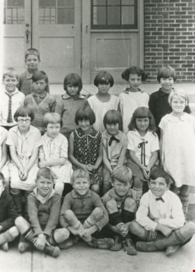
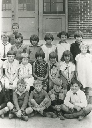
- Photograph of a Second Street School class taken outside of the school. Back row, left to right: Kenneth Wilson, Victor Spong, Gordon Ramsey, Murdoch McLeod, Keith Waite, Frank Trewern, Herbert Spong, and Charlie Trewern. Next row, left to right: Mina Fraser, Florence Wilson, Ethel Beamish, Elizabeth Murray, Gladys Brown, Gwen Allman, Ethel Meade, Jean Campbell, Dorothy White, Masie Frost, and Doreen Burton. 2nd row from front, left to right: Madge Donald, Ilma Beamish, Annie McDonald, Edna Townsend, Jessie Murray, Frances Atkinson, Elizabeth Moody, Helen Sutherland, and Helen Spong. Front row, left to right: Leslie Roy, Harold Allman, Bernard Gosse, Stanley Owen, Ralph Stapely, Percey Bettles, Archie Card, Norman Swift, and Gilbert Bettles. The teacher, at back, is Miss Sutcliffe.
- Subjects
- Occupations - Teachers
- Media Type
- Photograph
- Notes
- Title based on contents of photograph
- Geographic Access
- 2nd Street
- Street Address
- 7502 2nd Street
- Historic Neighbourhood
- East Burnaby (Historic Neighbourhood)
- Planning Study Area
- Second Street Area
Images
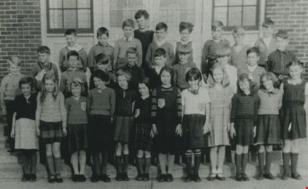
Second Street School class
https://search.heritageburnaby.ca/link/archivedescription35352
- Repository
- City of Burnaby Archives
- Date
- 1928 (date of original), copied 1986
- Collection/Fonds
- Burnaby Historical Society fonds
- Description Level
- Item
- Physical Description
- 1 photograph : b&w ; 12.7 x 17.8 cm print
- Scope and Content
- Photograph of Grade 2 class at Second Street School. (2nd from right) Hazel Butler; (3rd from right) Jessica Scott, daughter of Jim Scott, owner of Model Grocery. Their teacher was Miss Hurley (not in photograph). Other playmates: Ena Russell, Evelyn Salt, and Lorraine Patience (not idenified).
- Repository
- City of Burnaby Archives
- Date
- 1928 (date of original), copied 1986
- Collection/Fonds
- Burnaby Historical Society fonds
- Subseries
- Pioneer Tales subseries
- Physical Description
- 1 photograph : b&w ; 12.7 x 17.8 cm print
- Description Level
- Item
- Record No.
- 204-209
- Access Restriction
- No restrictions
- Reproduction Restriction
- No known restrictions
- Accession Number
- BHS1988-03
- Scope and Content
- Photograph of Grade 2 class at Second Street School. (2nd from right) Hazel Butler; (3rd from right) Jessica Scott, daughter of Jim Scott, owner of Model Grocery. Their teacher was Miss Hurley (not in photograph). Other playmates: Ena Russell, Evelyn Salt, and Lorraine Patience (not idenified).
- Media Type
- Photograph
- Notes
- Title based on contents of photograph
- Geographic Access
- 2nd Street
- Street Address
- 7502 2nd Street
- Historic Neighbourhood
- East Burnaby (Historic Neighbourhood)
- Planning Study Area
- Second Street Area
Images
Second Street School class
https://search.heritageburnaby.ca/link/archivedescription35354
- Repository
- City of Burnaby Archives
- Date
- 1928 (date of original), copied 1986
- Collection/Fonds
- Burnaby Historical Society fonds
- Description Level
- Item
- Physical Description
- 1 photograph : b&w ; 12.7 x 17.8 cm print
- Scope and Content
- Photograph of a Second Street School class. Identified is Jack Leaf (back row, far left). The teacher of this class was Miss Evans (not in photograph). Jack Leaf's father, George Leaf, opened one of the first businesses in Burnaby, the George Leaf General Store.
- Repository
- City of Burnaby Archives
- Date
- 1928 (date of original), copied 1986
- Collection/Fonds
- Burnaby Historical Society fonds
- Subseries
- Pioneer Tales subseries
- Physical Description
- 1 photograph : b&w ; 12.7 x 17.8 cm print
- Description Level
- Item
- Record No.
- 204-211
- Access Restriction
- No restrictions
- Reproduction Restriction
- No known restrictions
- Accession Number
- BHS1988-03
- Scope and Content
- Photograph of a Second Street School class. Identified is Jack Leaf (back row, far left). The teacher of this class was Miss Evans (not in photograph). Jack Leaf's father, George Leaf, opened one of the first businesses in Burnaby, the George Leaf General Store.
- Media Type
- Photograph
- Notes
- Title based on contents of photograph
- Geographic Access
- 2nd Street
- Street Address
- 7502 2nd Street
- Historic Neighbourhood
- East Burnaby (Historic Neighbourhood)
- Planning Study Area
- Second Street Area
Images

Second Street School class
https://search.heritageburnaby.ca/link/archivedescription35416
- Repository
- City of Burnaby Archives
- Date
- 1925 (date of original), copied 1986
- Collection/Fonds
- Burnaby Historical Society fonds
- Description Level
- Item
- Physical Description
- 1 photograph : b&w ; 12.7 x 17.8 cm print
- Scope and Content
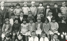
- Photograph of a Second Street School class. Identified: (2nd row, far left) Ellen "Nellie" Fetherstonhaugh (she later changed her first name to Leta and later became Leta Arden), and (2nd row, 2nd from right) Edith Fetherstonhaugh. Leta and Edith were daughters of Richard and Catherine Fetherstonh…
- Repository
- City of Burnaby Archives
- Date
- 1925 (date of original), copied 1986
- Collection/Fonds
- Burnaby Historical Society fonds
- Subseries
- Pioneer Tales subseries
- Physical Description
- 1 photograph : b&w ; 12.7 x 17.8 cm print
- Description Level
- Item
- Record No.
- 204-273
- Access Restriction
- No restrictions
- Reproduction Restriction
- No known restrictions
- Accession Number
- BHS1988-03
- Scope and Content
- Photograph of a Second Street School class. Identified: (2nd row, far left) Ellen "Nellie" Fetherstonhaugh (she later changed her first name to Leta and later became Leta Arden), and (2nd row, 2nd from right) Edith Fetherstonhaugh. Leta and Edith were daughters of Richard and Catherine Fetherstonhaugh (nee McCusker).
- Media Type
- Photograph
- Notes
- Title based on contents of photograph
- Geographic Access
- 2nd Street
- Street Address
- 7502 2nd Street
- Historic Neighbourhood
- East Burnaby (Historic Neighbourhood)
- Planning Study Area
- Second Street Area
Images

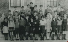
Second Street School Grade 2 class
https://search.heritageburnaby.ca/link/archivedescription36813
- Repository
- City of Burnaby Archives
- Date
- 1934 (date of original), copied 1992
- Collection/Fonds
- Burnaby Historical Society fonds
- Description Level
- Item
- Physical Description
- 1 photograph : b&w ; 7.7 x 12.2 cm print
- Scope and Content
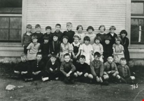
- Photograph of a Second Street School Grade 2 class. Identified: (top row, 2nd from left) Clarence Henshaw, and (middle row, 3rd from left) Gordon Henshaw. The school principal was Mrs. Potkins (not in photograph).
- Repository
- City of Burnaby Archives
- Date
- 1934 (date of original), copied 1992
- Collection/Fonds
- Burnaby Historical Society fonds
- Subseries
- Burnaby Centennial Anthology subseries
- Physical Description
- 1 photograph : b&w ; 7.7 x 12.2 cm print
- Description Level
- Item
- Record No.
- 315-271
- Access Restriction
- No restrictions
- Reproduction Restriction
- No known restrictions
- Accession Number
- BHS1994-04
- Scope and Content
- Photograph of a Second Street School Grade 2 class. Identified: (top row, 2nd from left) Clarence Henshaw, and (middle row, 3rd from left) Gordon Henshaw. The school principal was Mrs. Potkins (not in photograph).
- Media Type
- Photograph
- Notes
- Title based on contents of photograph
- Geographic Access
- 2nd Street
- Street Address
- 7502 2nd Street
- Historic Neighbourhood
- East Burnaby (Historic Neighbourhood)
- Planning Study Area
- Second Street Area
Images
![Second Street School literacy program, [2005] thumbnail](/media/hpo/_Data/_Archives_Images/_Unrestricted/535/535-1856-1.jpg?width=280)
Second Street School literacy program
https://search.heritageburnaby.ca/link/archivedescription96159
- Repository
- City of Burnaby Archives
- Date
- [2005]
- Collection/Fonds
- Burnaby NewsLeader photograph collection
- Description Level
- File
- Physical Description
- 2 photographs (tiff) : col.
- Scope and Content
- File contains photographs of Second Street Community School students participating in a grade 4 literacy program for boys. Photographs depict the students working with Plasticine to create dioramas based on Where the Wild Things and reading a Goosebumps novel.
- Repository
- City of Burnaby Archives
- Date
- [2005]
- Collection/Fonds
- Burnaby NewsLeader photograph collection
- Physical Description
- 2 photographs (tiff) : col.
- Description Level
- File
- Record No.
- 535-1856
- Access Restriction
- No restrictions
- Reproduction Restriction
- No restrictions
- Accession Number
- 2018-12
- Scope and Content
- File contains photographs of Second Street Community School students participating in a grade 4 literacy program for boys. Photographs depict the students working with Plasticine to create dioramas based on Where the Wild Things and reading a Goosebumps novel.
- Names
- Second Street School
- Media Type
- Photograph
- Photographer
- Bartel, Mario
- Notes
- Title based on caption
- Collected by editorial for use in a January 2005 issue of the Burnaby NewsLeader
- Caption from metadata for 535-1856-1: "Harriss Brammell, James Do and Andy Hehar work on plastecine dioramas based on scenes from a book they've been reading in their Grade 4 classroom, Where the Wild Things Are. Their teacher, Barton Lim, has developed a literacy program to encourage boys to read, which includes getting them involved in activities related to stories."
- Caption from metadata for 535-1856-2: "Sonu Kainth, a Grade 4 student at Second St. Community School, says he likes to read scary books, like Goosebumps. His teacher, Barton Lim, has developed a literacy program to encourage boys to read."
- Geographic Access
- 2nd Street
- Street Address
- 7502 2nd Street
- Historic Neighbourhood
- East Burnaby (Historic Neighbourhood)
- Planning Study Area
- Second Street Area
Images
![Second Street School literacy program, [2005] thumbnail](/media/hpo/_Data/_Archives_Images/_Unrestricted/535/535-1856-1.jpg)
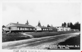
Senior Citizen Housing Project # 6
https://search.heritageburnaby.ca/link/archivedescription64660
- Repository
- City of Burnaby Archives
- Date
- 1954
- Collection/Fonds
- Ernest Winch fonds
- Description Level
- Item
- Physical Description
- 1 photograph : b&w postcard ; 8 x 13 cm
- Scope and Content
- Photographic postcard of New Vista Society's Senior Citizen Housing Project no. 6 on 11th Avenue in Burnaby.
- Repository
- City of Burnaby Archives
- Date
- 1954
- Collection/Fonds
- Ernest Winch fonds
- Physical Description
- 1 photograph : b&w postcard ; 8 x 13 cm
- Description Level
- Item
- Record No.
- 514-009
- Access Restriction
- No restrictions
- Reproduction Restriction
- Reproduce for fair dealing purposes only
- Accession Number
- 2010-06
- Scope and Content
- Photographic postcard of New Vista Society's Senior Citizen Housing Project no. 6 on 11th Avenue in Burnaby.
- Names
- New Vista Society
- Media Type
- Photograph
- Notes
- Transcribed title
- Photographer's note on recto of photograph reads: "Senior Citizen Housing Project # 6 / Burnaby, B.C., 1954"
- Stamp at border of photograph reads: "THE NEW VISTA SOCIETY"
- Geographic Access
- 11th Avenue
- Historic Neighbourhood
- East Burnaby (Historic Neighbourhood)
- Planning Study Area
- Second Street Area
Images

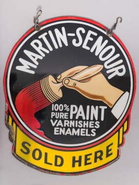
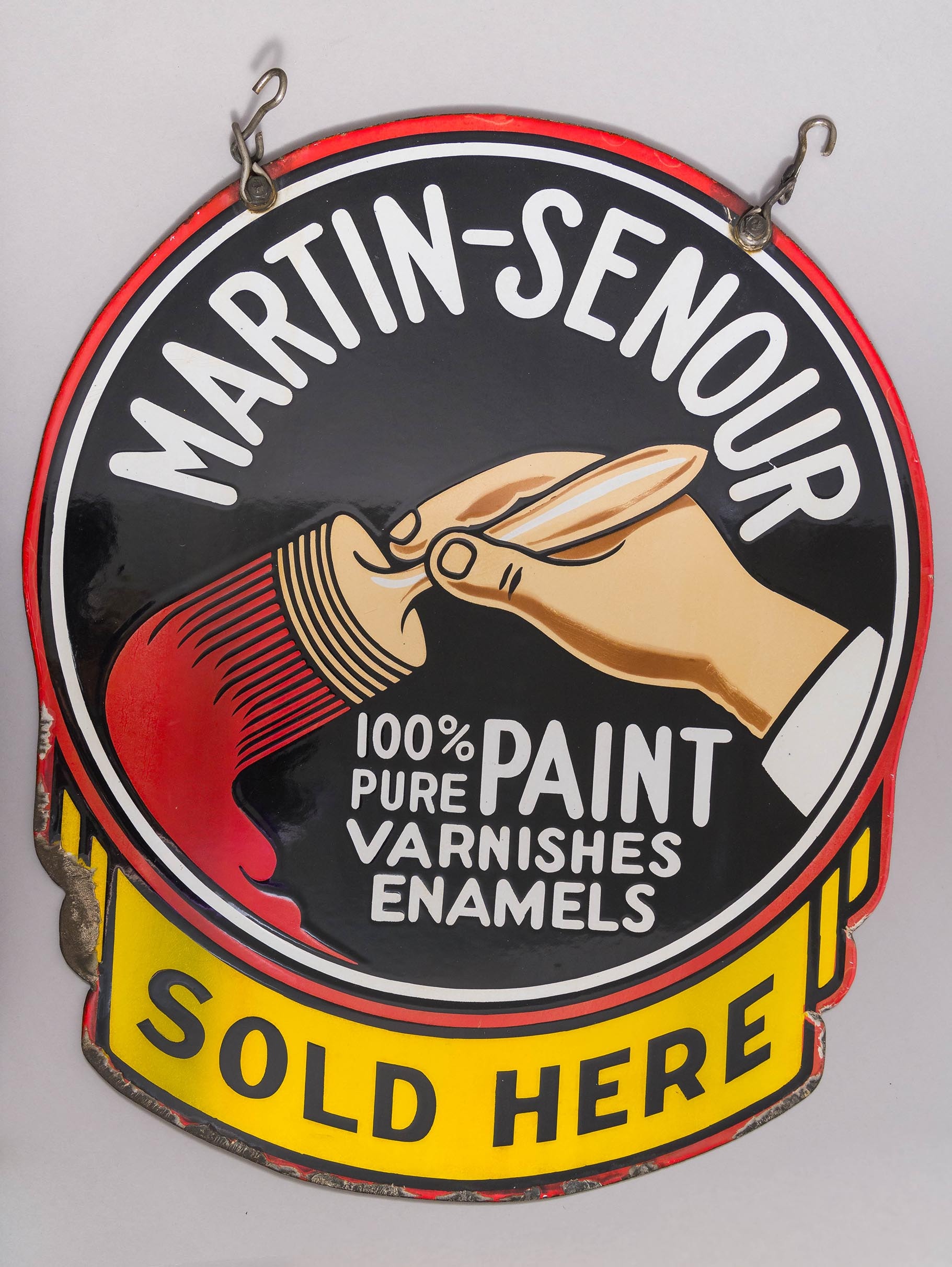
sign
https://search.heritageburnaby.ca/link/museumartifact14382
- Repository
- Burnaby Village Museum
- Accession Code
- HV984.19.1
- Description
- Sign, enamelled, "Martin and Senour Co. Paint", from the Whitechurch Hardware Building
- Object History
- This sign is from a hardware store that previously operated out of Bell's Dry Goods on 6th Avenue in Burnaby until 1972.
- Classification
- Written Communication T&E - - Writing Media
- Object Term
- Sign
- Subjects
- Communication Artifacts
- Historic Neighbourhood
- East Burnaby (Historic Neighbourhood)
- Planning Study Area
- Second Street Area
Images

sign
https://search.heritageburnaby.ca/link/museumartifact86154
- Repository
- Burnaby Village Museum
- Accession Code
- HV974.96.2
- Description
- Exterior hanging sign; "Whitechurch Hardware" name.
- Object History
- The Bell's Dry Goods building was built in 1922 by Clifford Tuckey with a small lean to structure on the back housing a kitchen and bedroom. The building was located on the northwest corner of Sixth Street and Thirteenth Avenue in Burnaby. William Bell (1884-1952) and Flora Bell (nee Connell) (1889-1953) immigrated to Burnaby from Scotland between 1917 and 1918. In about 1924, the building was purchased by William and Flora Bell. Flora operated "Bell's Dry Goods" store out of the building and the couple lived at the back of the store. William worked as a driver for a local lumber mill. Bell's Dry Goods was in operation in this one storey building between 1925 and 1937 with the building address, 1314 Sixth Street (later 7695 Sixth Street). In 1927, they moved to a house located on Thirteenth Avenue while they converted the back of the store to include the East Burnaby Post Office. In 1937, the Bells moved the one storey "Bell's Dry Goods" building a little further north and built a two storey building on the corner. Flora continued to operate Bell's Dry Goods on the ground level of the new building until 1941 and the couple lived upstairs. The new two storey building assumed the address of 1314 Sixth Street (later 7695 Sixth Street) and the older one storey building obtained a new address of 1316 Sixth Street (later 7685 Sixth Street). The East Burnaby Post Office continued to operate at 1314 Sixth Street until about 1954. On December 1, 1937, Maurice Whitechurch moved his Whitechurch Hardware store into the one storey building which he rented out from the Bells. In 1943, Maurice Whitechurch purchased the building from the Bells and Whitechurch Hardware store continued to operated at this location until the Spring of 1973. In June 1973, Mr. Fergie Will bought the store and the building was donated to Heritage Village (Burnaby Village Museum). In August 1974, the building was relocated to Heritage Village and opened as a carpentry shop exhibit in 1975. The building underwent several repairs and restorations over the years. After it was moved to Heritage Village, a lean to was built on the back of the building by museum staff. The lean to was demolished between 1993 and 1994 after the building was put on a new foundation. In 1995, it underwent a series of structural repairs to restore it to Bell's Dry Goods store, opening on August 6, 1996.
- Classification
- Written Communication T&E
- Object Term
- Sign, Identification
- Subjects
- Communication Artifacts
- Historic Neighbourhood
- East Burnaby (Historic Neighbourhood)
- Planning Study Area
- Second Street Area
Images

sink backsplash
https://search.heritageburnaby.ca/link/museumartifact91424
- Repository
- Burnaby Village Museum
- Accession Code
- BV021.21.65
- Description
- Rectangular piece of white metal painted pink, with curved edges at the top and two openings centre-top where faucets would sit.
- Object History
- Object was found in the Love Farmhouse attic August 2021, where it had been stored since the farmhouse restoration project in the late 1990's. This object is an original piece from the home.
- Category
- 01. Built Environment Objects
- Classification
- Building Components - - Surface Elements
- Object Term
- Backsplash
- Colour
- White
- Pink
- Measurements
- height: 73 cm
- width: 29 cm
- depth: 3.5 cm
- Subjects
- Building Components
- Geographic Access
- Cumberland Street
- Historic Neighbourhood
- East Burnaby (Historic Neighbourhood)
Images

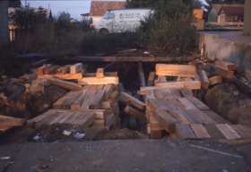
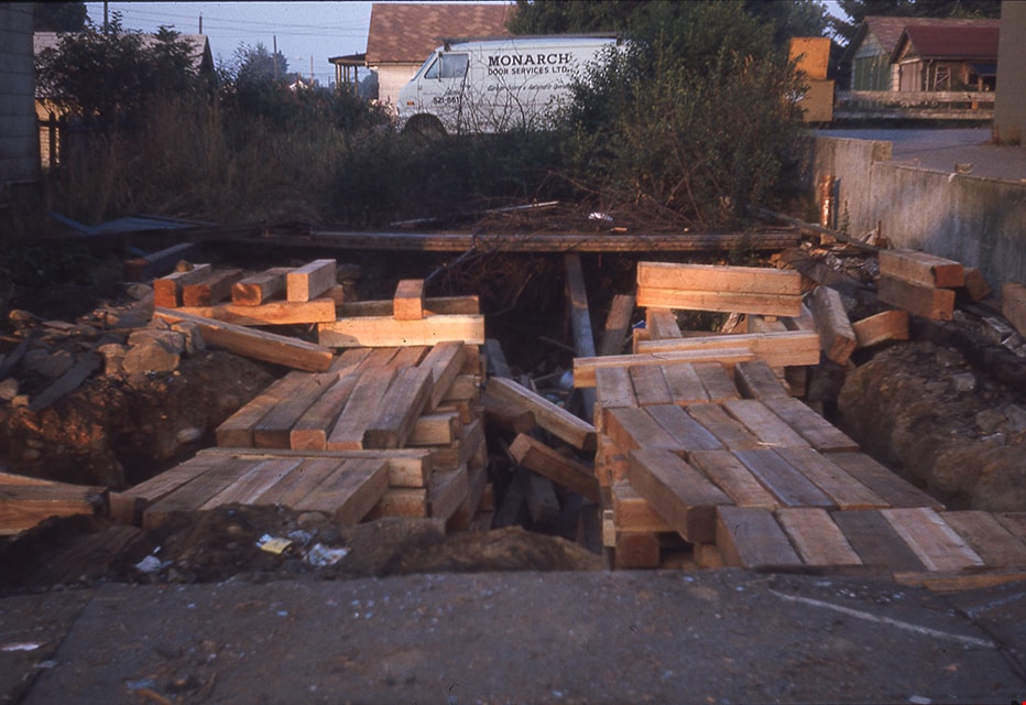
Site of former Whitechurch Hardware building
https://search.heritageburnaby.ca/link/museumdescription16903
- Repository
- Burnaby Village Museum
- Date
- Aug. 1974
- Collection/Fonds
- Burnaby Village Museum fonds
- Description Level
- Item
- Physical Description
- 1 photograph : col. slide ; 35 mm
- Scope and Content
- Photograph of timbers on the ground after the Whitechurch Hardware building was moved by Nickel Brothers house moving company from 7685 Sixth Street to Heritage Village (Burnaby Village Museum.
- Repository
- Burnaby Village Museum
- Collection/Fonds
- Burnaby Village Museum fonds
- Subseries
- Bell's building photographs subseries
- Description Level
- Item
- Physical Description
- 1 photograph : col. slide ; 35 mm
- Scope and Content
- Photograph of timbers on the ground after the Whitechurch Hardware building was moved by Nickel Brothers house moving company from 7685 Sixth Street to Heritage Village (Burnaby Village Museum.
- Geographic Access
- 6th Street
- Street Address
- 7685 6th Street
- Accession Code
- BV020.5.1873
- Access Restriction
- No restrictions
- Reproduction Restriction
- No known restrictions
- Date
- Aug. 1974
- Media Type
- Photograph
- Historic Neighbourhood
- East Burnaby (Historic Neighbourhood)
- Planning Study Area
- Second Street Area
- Scan Resolution
- 2400
- Scale
- 100
- Notes
- Title based on contents of photograph
- Note in blue ink on slide frame reads: "Timbers after / Whitechurch / removed from site"
Images
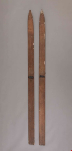
skis
https://search.heritageburnaby.ca/link/museumartifact36910
- Repository
- Burnaby Village Museum
- Accession Code
- BV988.33.22
- Description
- Home made skis made by William Parker. The original leather bindings are mostly gone, only one broken, dark coloured leather strap remains.
- Object History
- The skis were found in the Jesse Love farmhouse when moved to the Museum. The skis were hand made by Bill Parker, grandson of Jesse Love and son of Sarah Parker (Love) and William Parker. He made them while living in the Love farmhouse as a young man. He often did woodworking in the kitchen, after the bath tub was moved upstairs and before the kitchen was remodeled. When he was older his woodwork projects were done in the wood working shed outside. The skis were originally flat, but he found they did not work well. After observing people on store bought skis, he tried to steam the wood and weigh down the ends to get the tips of the skis to curve. He use the skis to around the yard and down the hill of Cumberland St. Bill later used the skis as a young adult while courting his wife. The skis were stored in the house and forgotten.
- A pair of skis in one corner of the farmhouse kitchen are visible in photographs of the kitchen taken in the early 1970.
- Maker
- Bill Parker
- Country Made
- Canada
- Province Made
- British Columbia
- Site/City Made
- Jesse Love Farmhouse
- Subjects
- Recreational Activities
- Geographic Access
- Cumberland Street
- Historic Neighbourhood
- East Burnaby (Historic Neighbourhood)
Images

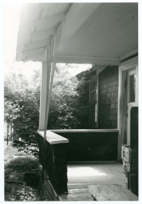
South side, west end of porch
https://search.heritageburnaby.ca/link/museumdescription10717
- Repository
- Burnaby Village Museum
- Date
- May 4, 1988
- Collection/Fonds
- Burnaby Village Museum fonds
- Description Level
- Item
- Physical Description
- 1 photograph : b&w ; 9 x 13 cm
- Scope and Content
- Photograph of the south side, west end of the porch on the Love farmhouse located at 7651 Cumberland Street (the corner of 14th Avenue and Cumberland Street).
- Repository
- Burnaby Village Museum
- Collection/Fonds
- Burnaby Village Museum fonds
- Series
- Jesse Love farmhouse series
- Description Level
- Item
- Physical Description
- 1 photograph : b&w ; 9 x 13 cm
- Material Details
- Photograph is part of Film roll "B" -24 b&w photographs that are a part of a collection described as BV018.41.82
- Scope and Content
- Photograph of the south side, west end of the porch on the Love farmhouse located at 7651 Cumberland Street (the corner of 14th Avenue and Cumberland Street).
- Subjects
- Buildings - Heritage
- Geographic Access
- Cumberland Street
- Street Address
- 7651 Cumberland Street
- Accession Code
- BV018.41.240
- Access Restriction
- No restrictions
- Reproduction Restriction
- No known restrictions
- Date
- May 4, 1988
- Media Type
- Photograph
- Historic Neighbourhood
- East Burnaby (Historic Neighbourhood)
- Planning Study Area
- Cariboo-Armstrong Area
- Related Material
- See BV018.41.82 for File Level Description
- Scan Resolution
- 600
- Scan Date
- 27-May-19
- Scale
- 100
- Photographer
- Wolf, Jim
- Notes
- Title based on contents of photograph
- Photograph is a part of file level description "Photographic documentation of changes and move" BV018.41.82
Images

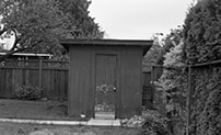
South view of Love House outbuilding in next yard
https://search.heritageburnaby.ca/link/museumdescription10761
- Repository
- Burnaby Village Museum
- Date
- May 6, 1988
- Collection/Fonds
- Burnaby Village Museum fonds
- Description Level
- Item
- Physical Description
- 1 photograph : b&w negative ; 35 mm
- Scope and Content
- South view of the Love farmhouse outbuilding in the next yard. The house is located at 7651 Cumberland Street (the corner of 14th Avenue and Cumberland Street).
- Repository
- Burnaby Village Museum
- Collection/Fonds
- Burnaby Village Museum fonds
- Series
- Jesse Love farmhouse series
- Description Level
- Item
- Physical Description
- 1 photograph : b&w negative ; 35 mm
- Material Details
- Photograph is part of Film roll "C" - 36 b&w photographs that are a part of a collection described as BV018.41.83
- Scope and Content
- South view of the Love farmhouse outbuilding in the next yard. The house is located at 7651 Cumberland Street (the corner of 14th Avenue and Cumberland Street).
- Subjects
- Buildings - Heritage
- Geographic Access
- Cumberland Street
- Street Address
- 7651 Cumberland Street
- Accession Code
- BV018.41.284
- Access Restriction
- No restrictions
- Reproduction Restriction
- No known restrictions
- Date
- May 6, 1988
- Media Type
- Photograph
- Historic Neighbourhood
- East Burnaby (Historic Neighbourhood)
- Planning Study Area
- Cariboo-Armstrong Area
- Related Material
- See BV018.41.82 for File Level Description
- Scan Resolution
- 2400
- Scan Date
- 5/19/2019
- Scale
- 100
- Photographer
- Wolf, Jim
- Notes
- Title based on contents of photograph
- Photograph is a part of file level description "Photographic documentation of changes and move" BV018.41.82
Images

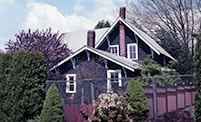
Southwest elevation
https://search.heritageburnaby.ca/link/museumdescription10697
- Repository
- Burnaby Village Museum
- Date
- May 4, 1988
- Collection/Fonds
- Burnaby Village Museum fonds
- Description Level
- Item
- Physical Description
- 1 photograph : col. negative ; 35 mm
- Scope and Content
- Photograph of the southwest elevation of the Love farmhouse located at 7651 Cumberland Street (the corner of 14th Avenue and Cumberland Street).The photograph was taken of the house once it was saved and acquired by the Burnaby Village Museum. View includes kitchen.
- Repository
- Burnaby Village Museum
- Collection/Fonds
- Burnaby Village Museum fonds
- Series
- Jesse Love farmhouse series
- Description Level
- Item
- Physical Description
- 1 photograph : col. negative ; 35 mm
- Material Details
- Photograph is part of Film roll "A"- 15 colour prints that are a part of a collection described as BV018.41.82
- Scope and Content
- Photograph of the southwest elevation of the Love farmhouse located at 7651 Cumberland Street (the corner of 14th Avenue and Cumberland Street).The photograph was taken of the house once it was saved and acquired by the Burnaby Village Museum. View includes kitchen.
- Subjects
- Buildings - Heritage
- Geographic Access
- Cumberland Street
- Street Address
- 7651 Cumberland Street
- Accession Code
- BV018.41.220
- Access Restriction
- No restrictions
- Reproduction Restriction
- No known restrictions
- Date
- May 4, 1988
- Media Type
- Photograph
- Historic Neighbourhood
- East Burnaby (Historic Neighbourhood)
- Planning Study Area
- Cariboo-Armstrong Area
- Related Material
- See BV018.41.82 for File Level Description
- Scan Resolution
- 2400
- Scan Date
- 5/19/2019
- Scale
- 100
- Photographer
- Wolf, Jim
- Notes
- Title based on contents of photograph
- Photograph is a part of file level description "Photographic documentation of changes and move" BV018.41.82
Images

Southwest view
https://search.heritageburnaby.ca/link/museumdescription10810
- Repository
- Burnaby Village Museum
- Date
- April 8, 1988
- Collection/Fonds
- Burnaby Village Museum fonds
- Description Level
- Item
- Physical Description
- 1 photograph : col. negative ; 35 mm
- Scope and Content
- Southwest view of the Love farmhouse while it was located at 7651 Cumberland Street (the corner of 14th Avenue and Cumberland Street). The photograph was taken of the house once it was saved and acquired by the Burnaby Village Museum.
- Repository
- Burnaby Village Museum
- Collection/Fonds
- Burnaby Village Museum fonds
- Series
- Jesse Love farmhouse series
- Description Level
- Item
- Physical Description
- 1 photograph : col. negative ; 35 mm
- Material Details
- Photograph is part of Film roll "F" - 23 colour photographs that are a part of a collection described as BV018.41.82
- Scope and Content
- Southwest view of the Love farmhouse while it was located at 7651 Cumberland Street (the corner of 14th Avenue and Cumberland Street). The photograph was taken of the house once it was saved and acquired by the Burnaby Village Museum.
- Subjects
- Buildings - Heritage
- Geographic Access
- Cumberland Street
- Street Address
- 7651 Cumberland Street
- Accession Code
- BV018.41.332
- Access Restriction
- No restrictions
- Reproduction Restriction
- No known restrictions
- Date
- April 8, 1988
- Media Type
- Photograph
- Historic Neighbourhood
- East Burnaby (Historic Neighbourhood)
- Planning Study Area
- Cariboo-Armstrong Area
- Related Material
- See BV018.41.82 for File Level Description
- Scan Resolution
- 2400
- Scan Date
- 13-May-19
- Scale
- 100
- Photographer
- Wolf, Jim
- Notes
- Title based on contents of photograph
- Photograph is a part of file level description "Photographic documentation of changes and move" BV018.41.82
Images

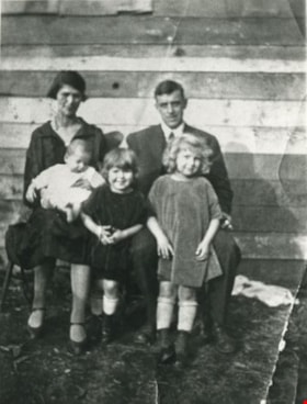
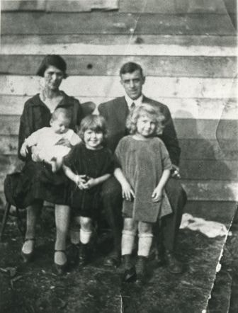
Stanley family
https://search.heritageburnaby.ca/link/archivedescription35731
- Repository
- City of Burnaby Archives
- Date
- 1926 (date of original), copied 1986
- Collection/Fonds
- Burnaby Historical Society fonds
- Description Level
- Item
- Physical Description
- 1 photograph : b&w ; 12.7 x 17.8 cm print
- Scope and Content
- Photograph of the Stanley family. Back, left to right: Esther Stanley and Frank Stanley. Front, left to right: Frank Stanley, Jr., Ina Stanley, and Mary Stanley.
- Repository
- City of Burnaby Archives
- Date
- 1926 (date of original), copied 1986
- Collection/Fonds
- Burnaby Historical Society fonds
- Subseries
- Pioneer Tales subseries
- Physical Description
- 1 photograph : b&w ; 12.7 x 17.8 cm print
- Description Level
- Item
- Record No.
- 204-589
- Access Restriction
- No restrictions
- Reproduction Restriction
- No known restrictions
- Accession Number
- BHS1988-03
- Scope and Content
- Photograph of the Stanley family. Back, left to right: Esther Stanley and Frank Stanley. Front, left to right: Frank Stanley, Jr., Ina Stanley, and Mary Stanley.
- Names
- Stanley, Esther Love
- Stanley, Frank Charles
- Stanley, Frank Jr
- Pearson, Mary Frances Stanley
- Shankie, Ina Esther Stanley
- Media Type
- Photograph
- Notes
- Title based on contents of photograph
- Geographic Access
- Cumberland Street
- Street Address
- 7651 Cumberland Street
- Historic Neighbourhood
- East Burnaby (Historic Neighbourhood)
- Planning Study Area
- Second Street Area
Images
![Subdivision plans in New Westminster District Group 1 – Burnaby
, [1890-1910] thumbnail](/media/hpo/_Data/_BVM_Cartographic_Material/1977/1977_0093_0014a_001.jpg?width=280)
Subdivision plans in New Westminster District Group 1 – Burnaby
https://search.heritageburnaby.ca/link/museumdescription6983
- Repository
- Burnaby Village Museum
- Date
- [1890-1910]
- Collection/Fonds
- Burnaby Village Museum Map collection
- Description Level
- File
- Physical Description
- 4 plans : blueprint ink on paper mounted on 2 sides of cardboard 76 x 102 cm
- Scope and Content
- Item consists of a large board of two New Westminster District Gp 1 - subdivision plans mounted on one side and two New Westminster District Gp 1 - subdivision plans mounted on the other side. Side A: 1. Blueprint "Plan of / Subdivision of Lot No. 69 / Group One / New Westminster District / Pro…
- Repository
- Burnaby Village Museum
- Collection/Fonds
- Burnaby Village Museum Map collection
- Description Level
- File
- Physical Description
- 4 plans : blueprint ink on paper mounted on 2 sides of cardboard 76 x 102 cm
- Material Details
- Scales [between 1:1584 and 1:3168]
- Index number on edge of board reads: "14"
- Scope and Content
- Item consists of a large board of two New Westminster District Gp 1 - subdivision plans mounted on one side and two New Westminster District Gp 1 - subdivision plans mounted on the other side. Side A: 1. Blueprint "Plan of / Subdivision of Lot No. 69 / Group One / New Westminster District / Property of Ernest Buse, Esq. / Scale 3 chs = 1 in. / Map No 290". Plan is signed by "Garden, Hermon and Burwell, Dom. Land Surveyor" (Geographic location: Burnaby) 2. Blueprint "Plan / of Subdivision / of Lots 1-19, 36-53 and 69-75 inclusive / in the Subdivision / of / Lot 30 / Group One / New Westminster District / Scale 2 chs = 1 in. Map No 631". Plan is signed by "Jno [sic] Strathern [sic] P.L.S." Names and Lot numbers are handwritten in red pencil in sections along Douglas Road and read: "20 - F / 21 - Fitherstruhaul [sic] / 22 - J.S. Craig / 23 - McGill & Dill / 24 / 25 / 26 / 27 / 28 - School / 29 - School / 30 - D. McDownall / 31 - W.J. Troloow [sic] / 32 - N.C. Nelson / 33 - _[sic] McGill / 34 - T.S.[sic] Craig / 35" (Geographic location: Burnaby) Side B: 1.Blueprint "Plan / of Subdivision / of Centre Portion / of Lot 28 / Group One / New Westminster District / Scale 200' = 1" / Map No 627". Plan is signed by "Jno Strathern / P.L.S." (Geographic location: Burnaby) 2. Blueprint "Plan / of Subdivision / of N.1/2 Lot 100 and S.1/2 Lot 101, / Group One / New Westminster District, BC / Scale 4 chs = 1 in." (Geographic location: Burnaby)
- Names
- Strathern, John
- Accession Code
- HV977.93.14
- Access Restriction
- No restrictions
- Reproduction Restriction
- No known restrictions
- Date
- [1890-1910]
- Media Type
- Cartographic Material
- Historic Neighbourhood
- Broadview (Historic Neighbourhood)
- East Burnaby (Historic Neighbourhood)
- Planning Study Area
- Cascade-Schou Area
- West Central Valley Area
- Second Street Area
- Lake City Area
- Scan Resolution
- 300
- Scale
- 72
- Notes
- Title based on contents of file
- Scale is measured in chains and feet. (One chain equals 792 inches)
- The term "Lot" can also refer to a "District Lot”
Images
![Subdivision plans in New Westminster District Group 1 – Burnaby
, [1890-1910] thumbnail](/media/hpo/_Data/_BVM_Cartographic_Material/1977/1977_0093_0014a_001.jpg)

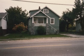
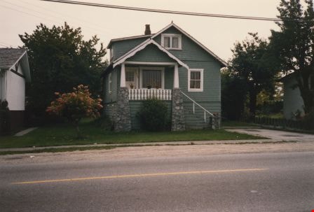
Sutherland house
https://search.heritageburnaby.ca/link/archivedescription35139
- Repository
- City of Burnaby Archives
- Date
- 1985
- Collection/Fonds
- Burnaby Historical Society fonds
- Description Level
- Item
- Physical Description
- 1 photograph : col. ; 11.1 x 14.8 cm
- Scope and Content
- Photograph of the Sutherland house, 8246 16th Avenue, built in 1912.
- Repository
- City of Burnaby Archives
- Date
- 1985
- Collection/Fonds
- Burnaby Historical Society fonds
- Subseries
- Bill Sutherland subseries
- Physical Description
- 1 photograph : col. ; 11.1 x 14.8 cm
- Description Level
- Item
- Record No.
- 202-001
- Access Restriction
- No restrictions
- Reproduction Restriction
- Reproduce for fair dealing purposes only
- Accession Number
- BHS1987-11
- Scope and Content
- Photograph of the Sutherland house, 8246 16th Avenue, built in 1912.
- Subjects
- Buildings - Residential - Houses
- Media Type
- Photograph
- Notes
- Title based on contents of photograph
- Annotation on the back of the photograph reads, "8246 16th Avenue. Built in 1912 by Mr. Sutherland."
- Geographic Access
- 16th Avenue
- Street Address
- 8246 16th Avenue
- Historic Neighbourhood
- East Burnaby (Historic Neighbourhood)
- Planning Study Area
- Second Street Area
Images