Narrow Results By
Creator
- Bekins Moving and Storage Company Limited 1
- British Columbia Underwriters' Association 4
- Burnett, David H. 1
- Burnett & McGugan, Engineers and Surveyors 1
- City Map and White Print Co. 1
- Coast Map and Blue Print Co. 1
- Geographia Limited 1
- Government of Canada - Department of the Interior 1
- Hill, Albert James 1
- Law, Yee "Herbert" 1
- Love Family 1
- McGugan, Donald Johnston 2
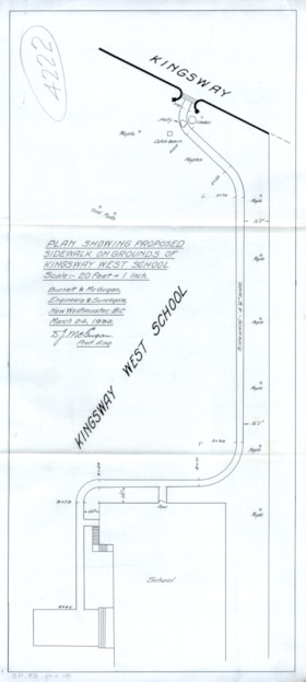
Proposed sidewalk on grounds of Kingsway West School
https://search.heritageburnaby.ca/link/museumdescription11917
- Repository
- Burnaby Village Museum
- Date
- March 24, 1932
- Collection/Fonds
- Ronald G. Scobbie collection
- Description Level
- Item
- Physical Description
- 1 survey plan : ink on waxed linen sheet ; 55 x 25 cm
- Scope and Content
- Item consists of a survey plan titled “Plan Showing Proposed / Sidewalk on Grounds of / Kingsway West School”
- Repository
- Burnaby Village Museum
- Collection/Fonds
- Ronald G. Scobbie collection
- Description Level
- Item
- Physical Description
- 1 survey plan : ink on waxed linen sheet ; 55 x 25 cm
- Material Details
- Scale 20’=1”
- Scope and Content
- Item consists of a survey plan titled “Plan Showing Proposed / Sidewalk on Grounds of / Kingsway West School”
- Creator
- McGugan, Donald Johnston
- Names
- Kingsway West School
- Accession Code
- BV003.83.40
- Access Restriction
- No restrictions
- Reproduction Restriction
- No known restrictions
- Date
- March 24, 1932
- Media Type
- Cartographic Material
- Scan Resolution
- 600
- Scan Date
- 15-Jan-2021
- Scale
- 100
- Notes
- Transcribed title
- Note in pencil reads: ‘4222”
Images
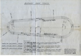
Burnaby Park track
https://search.heritageburnaby.ca/link/museumdescription11918
- Repository
- Burnaby Village Museum
- Date
- June 30, 1932
- Collection/Fonds
- Ronald G. Scobbie collection
- Description Level
- Item
- Physical Description
- 1 survey plan : ink on waxed linen sheet ; 27 x 39 cm
- Scope and Content
- Item consists of a survey plan titled “Burnaby Park Track”.
- Repository
- Burnaby Village Museum
- Collection/Fonds
- Ronald G. Scobbie collection
- Description Level
- Item
- Physical Description
- 1 survey plan : ink on waxed linen sheet ; 27 x 39 cm
- Scope and Content
- Item consists of a survey plan titled “Burnaby Park Track”.
- Accession Code
- BV003.83.41
- Access Restriction
- No restrictions
- Reproduction Restriction
- No known restrictions
- Date
- June 30, 1932
- Media Type
- Cartographic Material
- Notes
- Transcribed title
- Note in pencil reads: ‘4222”
Images
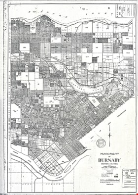
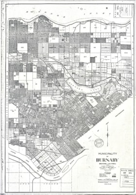
Municipality of Burnaby
https://search.heritageburnaby.ca/link/museumdescription13096
- Repository
- Burnaby Village Museum
- Date
- 1936
- Collection/Fonds
- Burnaby Village Museum Map collection
- Description Level
- Item
- Physical Description
- 1 map : b&w print on paper ; 59 x 43 cm
- Scope and Content
- Map of the Municipality of Burnaby compiled and published by City Map and White Print Co.
- Repository
- Burnaby Village Museum
- Collection/Fonds
- Burnaby Village Museum Map collection
- Description Level
- Item
- Physical Description
- 1 map : b&w print on paper ; 59 x 43 cm
- Scope and Content
- Map of the Municipality of Burnaby compiled and published by City Map and White Print Co.
- Creator
- City Map and White Print Co.
- Publisher
- City Map and White Print Co.
- Accession Code
- HV976.158.7
- Access Restriction
- No restrictions
- Reproduction Restriction
- No known restrictions
- Date
- 1936
- Media Type
- Cartographic Material
- Scan Resolution
- 600
- Scan Date
- 2022-04-06
- Scale
- 100
- Notes
- Title based on content of map
- Title on map reads: "MUNICIPALITY / OF / BURNABY / BRITISH COLUMBIA / Compiled and Published by / CITY MAP AND WHITE PRINT CO."
- Stamp on map reads: "SFU LIBRARY / SEP 1974 / G. 3514 / B87 / 1936"
- Stamp on map reads: "SFU LIBRARY / AUG 1973 / G. 3514 / B87 / 1936"
- Cirular seal stamp on map reads: "The University of / Library / British Columbia"
Zoomable Images
Herbert Yee Law family fonds
https://search.heritageburnaby.ca/link/museumdescription18929
- Repository
- Burnaby Village Museum
- Date
- [1938-1959] (date of originals), 2017-2019 (date of duplication)
- Collection/Fonds
- Herbert Yee Law family fonds
- Description Level
- Fonds
- Physical Description
- 4 photographs (tiffs + jpgs)
- Scope and Content
- Fonds consists of a collection of photographs of Herbert Yee Law, United Fruit Growers, his farm on Marine Drive and a scanned copy of a survey plan of District Lots 163, 162, 157, 158 and 165.
- Repository
- Burnaby Village Museum
- Collection/Fonds
- Herbert Yee Law family fonds
- Description Level
- Fonds
- Physical Description
- 4 photographs (tiffs + jpgs)
- Scope and Content
- Fonds consists of a collection of photographs of Herbert Yee Law, United Fruit Growers, his farm on Marine Drive and a scanned copy of a survey plan of District Lots 163, 162, 157, 158 and 165.
- History
- Herbert (Yee) Law was born in New Westminster British Columbia in 1916. Between 1938 and 1945, Yee Law worked for the United Fraser Growers Limited in Vancouver. The company was a wholesaler that purchased produce from Chinese farmers. In 1948 Yee Law purchased land from another Chinese family along Marine Drive in the Big Bend Area of Burnaby. From this location, Yee Law operated a Chinese market garden. Yee Law and his wife Jean had five daughters who attended schools in the area including Riverway West School, McPherson Park School and Burnaby South High School. In 1954, Yee Law continued to live in the area but left his farm to work for a plastic bag company on Annacis Island. Herbert (Yee) Law died in 2003.
- Creator
- Law, Yee "Herbert"
- Accession Code
- BV017.40
- BV019.11
- Date
- [1938-1959] (date of originals), 2017-2019 (date of duplication)
- Media Type
- Photograph
- Cartographic Material
- Notes
- Title based on contents of fonds


