Narrow Results By
Decade
- 2020s 223
- 2010s 148
- 2000s 1821
- 1990s 2867
- 1980s 1363
- 1970s 3510
- 1960s 1351
- 1950s 1669
- 1940s
- 1930s 2066
- 1920s 2345
- 1910s 1851
- 1900s 847
- 1890s 249
- 1880s 165
- 1870s 72
- 1860s 123
- 1850s 14
- 1840s 5
- 1830s 3
- 1820s 2
- 1810s 3
- 1800s 3
- 1790s 2
- 1780s 2
- 1770s 2
- 1760s 2
- 1750s 2
- 1740s 2
- 1730s 2
- 1720s 2
- 1710s 2
- 1700s 2
- 1690s 2
- 1680s 2
- 1670s 1
- 1660s 1
- 1650s 1
- 1640s 1
- 1630s 1
- 1620s 1
- 1610s 1
- 1600s 1
- 1590s 1
- 1580s 1
- 1570s 1
- 1560s 1
- 1550s 1
- 1540s 1
- 1530s 1
- 1520s 2
- 1510s 1
- 1500s 1
- 1490s 1
- 1480s 1
Subject
- Accidents - Automobile Accidents 3
- Accidents - Train Accidents 6
- Advertising Medium - Signs and Signboards 10
- Aerial Photographs 7
- Agricultural Tools and Equipment 5
- Agricultural Tools and Equipment - Cultivators 2
- Agricultural Tools and Equipment - Gardening Equipment 1
- Agricultural Tools and Equipment - Plows 1
- Agricultural Tools and Equipment - Tractors 1
- Agriculture - Crops 1
- Agriculture - Farms 25
- Agriculture - Fruit and Berries 2

Alta Vista Neighbourhood
https://search.heritageburnaby.ca/link/landmark707
- Repository
- Burnaby Heritage Planning
- Associated Dates
- 1925-1954
- Heritage Value
- As with many areas of Burnaby during this period, the years after World War Two marked a rapid growth in residential development in the Alta-Vista Neighbourhood. Subdivisions like Sussex and Suncrest were built and new schools and amenities were constructed to meet the demands of increased population.
- Historic Neighbourhood
- Alta Vista (Historic Neighbourhood)
- Planning Study Area
- Sussex-Nelson Area
Images


Barnet Mountain Park Dedication
https://search.heritageburnaby.ca/link/landmark686
- Repository
- Burnaby Heritage Planning
- Associated Dates
- 1942
- Heritage Value
- For years, the idea of creating a park on Burnaby Mountain was favoured by people in Burnaby. In 1930, the Municipal Engineer submitted a report recommending that the city acquire land in the area with a view towards formally dedicating the space for public use. In 1942, Commissioner Richard Bolton enacted Bylaw 1772 which officially dedicated the mountain as public park.
- Historic Neighbourhood
- Barnet (Historic Neighbourhood)
- Planning Study Area
- Burnaby Mountain Area
Images


Barnet Neighbourhood
https://search.heritageburnaby.ca/link/landmark681
- Repository
- Burnaby Heritage Planning
- Associated Dates
- 1925-1954
- Heritage Value
- In 1925, the mill at Barnet was under new ownership and was known as the Barnet Lumber Company. It was one of the most successful local employers in Burnaby until the 1930s, when the economic crisis of the Great Depression resulted in a strike at the mill. The City of Burnaby eventually assumed control of the site - including all of the homes - when the company failed to pay its taxes. The City then dismantled the mill and resold the property in two parts - the eastern section would become the Kapoor sawmill and the western portion, the McColl-Frontenac Oil Company.
- Historic Neighbourhood
- Barnet (Historic Neighbourhood)
- Planning Study Area
- Burnaby Mountain Area
Images


Brentwood Neighbourhood
https://search.heritageburnaby.ca/link/landmark669
- Repository
- Burnaby Heritage Planning
- Associated Dates
- 1925-1954
- Heritage Value
- In July, 1953, Burnaby's Municipal Council gave approval for the construction of a $12,000,000 residential and shopping development to be called Brentwood Park, located on the northeast corner of Lougheed and Willingdon. Plans called for about 400 homes and a 30-acre shopping centre to be built in this new subdivision - the first large residential subdivision in Burnaby to be developed with sewers and paved streets as well as other services.
- Planning Study Area
- Brentwood Area
Images


Broadview Neighbourhood
https://search.heritageburnaby.ca/link/landmark687
- Repository
- Burnaby Heritage Planning
- Associated Dates
- 1925-1954
- Heritage Value
- Development in the Broadview area slowed during World War Two, but after the war, the area became home to a number of industrial sites. The first major plant to be built here was the Dominion Bridge Company which opened in 1930.
- Historic Neighbourhood
- Broadview (Historic Neighbourhood)
- Planning Study Area
- Cascade-Schou Area
Images


Burnaby Lake Neighbourhood
https://search.heritageburnaby.ca/link/landmark700
- Repository
- Burnaby Heritage Planning
- Associated Dates
- 1925-1954
- Heritage Value
- After World War I and the Great Depression of the 1930s, more homes were constructed and subdivisions created in the Burnaby Lake district. The area around Deer Lake gained a reputation for being an "artistic development of commodious homes with park-like grounds."
- Historic Neighbourhood
- Burnaby Lake (Historic Neighbourhood)
- Planning Study Area
- Burnaby Lake Area
Images


Burnaby North High School
https://search.heritageburnaby.ca/link/landmark745
- Repository
- Burnaby Heritage Planning
- Associated Dates
- 1923-1982
- Street View URL
- Google Maps Street View
- Repository
- Burnaby Heritage Planning
- Geographic Access
- Willingdon Avenue
- Associated Dates
- 1923-1982
- Heritage Value
- Burnaby North and Burnaby South were the first high schools built in the City. Before the high school opened, Burnaby students had to travel to Vancouver if they wished to pursue education beyond an elementary level. In 1921, arrangements were made to use the basement of the Presbyterian Church for instruction of local students. By 1922 the Burnaby North High School opened at its first permanent location (4375 Pandora Street - which is now Rosser Elementary). In 1945, the Willingdon Avenue site was built and was used until a new building was constructed in 1961 on Hammarskjold Drive. From 1962, the school was used as Burnaby Heights Junior High school, but it closed in 1982 and the junior high students went to the new Burnaby North on Hammarskjold.
- Historic Neighbourhood
- Capitol Hill (Historic Neighbourhood)
- Planning Study Area
- Capitol Hill Area
- Street Address
- 250 Willingdon Avenue
- Street View URL
- Google Maps Street View
Images


Burnaby South High School
https://search.heritageburnaby.ca/link/landmark770
- Repository
- Burnaby Heritage Planning
- Associated Dates
- 1922-1988
- Street View URL
- Google Maps Street View
- Repository
- Burnaby Heritage Planning
- Geographic Access
- Southoaks Crescent
- Associated Dates
- 1922-1988
- Heritage Value
- Burnaby South and Burnaby North were Burnaby's first high schools. The first rooms of the school were built in 1922 on the same grounds as the Kingsway East Elementary School. In 1940, a two-storey building was erected and additions were made in 1963, 1967 and 1972. Kingsway East closed in 1925 and its buildings were used by the high school for Industrial Arts and Home Economics. In the early 1990s, a new "urban education centre" (Burnaby South/B.C. School for the Deaf) was opened, replacing the old Burnaby South High School.
- Historic Neighbourhood
- Edmonds (Historic Neighbourhood)
- Planning Study Area
- Kingsway-Beresford Area
- Street Address
- 6650 Southoaks Crescent
- Street View URL
- Google Maps Street View
Images


Burnaby South High School Cenotaph & Memorial Tennis Courts
https://search.heritageburnaby.ca/link/landmark547
- Repository
- Burnaby Heritage Planning
- Description
- This memorial comprises a cenotaph and three tennis courts: the former a monument of British Columbia granite inscribed with the names of fifty-one students of Burnaby South High School who lost their lives in the Second World War; and the latter a living memorial to these former students.
- Associated Dates
- 1948
- Formal Recognition
- Heritage Designation, Community Heritage Register
- Street View URL
- Google Maps Street View
- Repository
- Burnaby Heritage Planning
- Geographic Access
- Southoaks Crescent
- Associated Dates
- 1948
- Formal Recognition
- Heritage Designation, Community Heritage Register
- Enactment Type
- Bylaw No. 9807
- Enactment Date
- 23/11/1992
- Description
- This memorial comprises a cenotaph and three tennis courts: the former a monument of British Columbia granite inscribed with the names of fifty-one students of Burnaby South High School who lost their lives in the Second World War; and the latter a living memorial to these former students.
- Heritage Value
- This memorial is important for its spiritual, symbolic, and cultural associations for the former students of Burnaby South High School, and for all youth in the community. The cenotaph is of personal significance to the families of those who lost their lives. The unusual combination of cenotaph and living memorial - the tennis courts - represents a rare statement of a community's commitment to not allow the sacrifice of its youth to be forgotten by providing an active facility which draw people to the place on a regular basis rather than just on occasions of remembrance. As such it is an important symbol of a humanitarian ethic. In combination with the Kingsway East School, now rehabilitated as the Alan Emmott Centre, this memorial represents a valuable haven of green-space and recreation in the high-density urban development that now surrounds it.
- Defining Elements
- Key elements that define the heritage character of the Burnaby South High School Cenotaph & Memorial Tennis Courts include the: - location of the cenotaph adjacent to the living memorial - spatial association of this memorial and the remaining school building - physical fabric of both the granite monument and the tennis courts
- Historic Neighbourhood
- Edmonds (Historic Neighbourhood)
- Planning Study Area
- Kingsway-Beresford Area
- Function
- Primary Current--Public Feature
- Primary Historic--Public Feature
- Community
- Burnaby
- Cadastral Identifier
- P.I.D. No. 016-367-154 Legal Description: Lot 1, District Lot 96, Group 1 New Westminster District, Plan 86581
- Boundaries
- Burnaby South High School Cenotaph & Memorial Tennis Courts is comprised of a single municipally-owned property located at 6650 Southoaks Crescent, Burnaby.
- Area
- 6,070.00
- Contributing Resource
- Building
- Landscape Feature
- Structure
- Ownership
- Public (local)
- Documentation
- Heritage Site Files: PC77000 20. City of Burnaby Planning and Building Department, 4949 Canada Way, Burnaby, B.C., V5G 1M2
- Street Address
- 6650 Southoaks Crescent
- Street View URL
- Google Maps Street View
Images


Burquitlam Neighbourhood
https://search.heritageburnaby.ca/link/landmark703
- Repository
- Burnaby Heritage Planning
- Associated Dates
- 1925-1954
- Heritage Value
- By the 1950s, the Burquitlam Neighbourhood was becoming a residential and commercial centre for the northeast section of Burnaby. The Sullivan Heights area was developed as a single-family residential area with the Lyndhurst School opening in 1954. The completion of the Lougheed Highway in 1953 encouraged more commercial and retail development and fostered the growth of the neighbourhood throughout this period.
- Historic Neighbourhood
- Burquitlam (Historic Neighbourhood)
- Planning Study Area
- Lyndhurst Area
Images


Capitol Hill Community Hall
https://search.heritageburnaby.ca/link/landmark563
- Repository
- Burnaby Heritage Planning
- Description
- Public building.
- Associated Dates
- 1948
- Street View URL
- Google Maps Street View
- Repository
- Burnaby Heritage Planning
- Geographic Access
- Howard Avenue
- Associated Dates
- 1948
- Description
- Public building.
- Heritage Value
- The Capitol Hill Community Hall was designed by local architect Harold Cullerne (1890-1976). After Cullerne returned from service during the First World War, he joined J.H. Bowman in a partnership that lasted from 1919 to 1934. After Bowman retired in 1934, Cullerne practiced on his own, continuing to work on schools and institutional buildings, such as the Art Deco Hollywood Theatre in Vancouver. In 1944, Cullerne designed a community hall for Capitol Hill; the scheme was delayed, and redesigned before it was finally built after the end of the Second World War. A simple front gabled roof hall structure, this hall is a monument to community spirit, erected by community members on a volunteer basis, and used for community events for over half a century. The hall replaced two earlier structures, both destroyed by fire, that had served the same purpose.
- Locality
- Capitol Hill
- Historic Neighbourhood
- Capitol Hill (Historic Neighbourhood)
- Planning Study Area
- Capitol Hill Area
- Architect
- Harold Cullerne
- Ownership
- Public (local)
- Street Address
- 361 Howard Avenue
- Street View URL
- Google Maps Street View
Images


Capitol Hill Neighbourhood
https://search.heritageburnaby.ca/link/landmark667
- Repository
- Burnaby Heritage Planning
- Associated Dates
- 1925-1954
- Heritage Value
- Although the Hastings street-car extension to Ellesmere opened in 1913 and there had been much speculation in the area during the real estate boom of 1909-1913, development in Capitol Hill did not really take off until after World War One when workers in Vancouver started to look to Burnaby for affordable but centrally-located neighbourhoods in which to build their homes. The 1913 one-room school had to be replaced in 1923 and in 1948, members of the community came together to build a new Community Hall.
- Historic Neighbourhood
- Capitol Hill (Historic Neighbourhood)
- Planning Study Area
- Capitol Hill Area
Images


Cascades Drive-In Theatre
https://search.heritageburnaby.ca/link/landmark689
- Repository
- Burnaby Heritage Planning
- Geographic Access
- Grandview Highway
- Associated Dates
- 1946
- Heritage Value
- The Cascades Drive-In Theatre was Canada's first drive-in and was started by George and William Steel and Joe and Art Johnson in 1946. Built along Grandview Highway (Canada Way) near Smith Street, the theatre opened on August 30, 1946. In 1977, the theatre was purchased by Don Soutar, Al Chappell and Norm Green and continued to operate until 1980. The property was then redeveloped as Cascades Village - a large condominium complex.
- Historic Neighbourhood
- Broadview (Historic Neighbourhood)
- Planning Study Area
- Cascade-Schou Area
- Street Address
- 4050 Grandview Highway
Images


Central Park Neighbourhood
https://search.heritageburnaby.ca/link/landmark688
- Repository
- Burnaby Heritage Planning
- Associated Dates
- 1925-1954
- Heritage Value
- Although still largely a rural area during the 1920s, subdivisions began appearing in the Central Park neighbourhood at this time. Development was slowed by the Great Depression of the 1930s but the influx of commercial buildings and new housing initiatives in the post-war boom led to a period of rapid growth especially in the Garden Village subdivision which was undertaken in 1953 with the plan to build 500 modern homes in the 140-acre site. Despite the closure of the interurban line in 1953, the neighbourhood remained an active commercial and residential centre.
- Historic Neighbourhood
- Central Park (Historic Neighbourhood)
- Planning Study Area
- Maywood Area
Images


Clinton School
https://search.heritageburnaby.ca/link/landmark709
- Repository
- Burnaby Heritage Planning
- Geographic Access
- Clinton Street
- Associated Dates
- 1948
- Heritage Value
- With the increasing settlement on the south slope between Kingsway and Marine Drive following World War Two, the old two-room school of Riverway East was considered inadequate so in 1948, the Clinton Elementary School opened. Clinton was to be the prototype of post-war elementary schools in Burnaby. It had no basement, no second storey and no high stairways. Classrooms were built in line and easily added as needed. Clinton had additions in 1950, 1951, 1957, 1964, 1965, 1967 and 1973.
- Historic Neighbourhood
- Alta Vista (Historic Neighbourhood)
- Planning Study Area
- Clinton-Glenwood Area
- Street Address
- 5858 Clinton Street
- Street View URL
- Google Maps Street View
Images


Crabtown
https://search.heritageburnaby.ca/link/landmark674
- Repository
- Burnaby Heritage Planning
- Associated Dates
- 1912-1957
- Heritage Value
- North Burnaby's waterfront was the location of a unique squatter's community known as Crabtown. Although its origins are obscure, it is believed that the first shacks were built before 1912. When the depression of 1913-1917 began, the shacks became permanent homes for impoverished workers. During the Great Depression of the 1930s, the community grew larger. Crabtown was not a slum, but a neighbourhood - the community even rallied together to build a water supply system and trails up the steep bluff with steps and banisters so children could go to school safely. In 1957, the National Harbours Board decided that Crabtown was encroaching on Federal property and evicted all 130 residents. Within a few months, residents were relocated and 114 homes were levelled.
- Historic Neighbourhood
- Vancouver Heights (Historic Neighbourhood)
- Planning Study Area
- Burnaby Heights Area
Images


Deer Lake Park
https://search.heritageburnaby.ca/link/landmark692
- Repository
- Burnaby Heritage Planning
- Associated Dates
- 1949
- Heritage Value
- As Burnaby developed into a more urban suburb of Vancouver and New Westminster the Deer Lake area retained much of its rural character. In 1949 Deer Lake park was established on the lake's eastern shore. The relocation of the Municipal Hall in the mid-1950s to the Deer Lake area began the vision of developing an administrative and cultural centre for Burnaby. The opportunity for developing this centre began with the opening of the Arts Centre, Century Gardens and the Burnaby Art Gallery in 1967. This was followed by the development of the Deer Lake Park as Burnaby's primary urban park.
- Historic Neighbourhood
- Burnaby Lake (Historic Neighbourhood)
- Planning Study Area
- Morley-Buckingham Area
- Street View URL
- Google Maps Street View
Images


Digney Speedway
https://search.heritageburnaby.ca/link/landmark693
- Repository
- Burnaby Heritage Planning
- Geographic Access
- MacPherson Avenue
- Irmin Street
- Associated Dates
- 1948
- Heritage Value
- Andy Digney built the speedway in South Burnaby in 1948. He was approached by the B.C. Midget Auto Racing Association, who were looking for a good location to race the smaller, racing cars, popular at the time. Digney owned property in the vicinity of present-day Metrotown that was centrally located and easily accessible via the interurban railway. Motorcycles were also raced in the early days of the track. In 1949, when the popularity of midget racing declined, Digney started racing roadsters. However, he struggled to find local drivers, and it was expensive to bring in drivers from elsewhere. In 1951 Digney found a winner: jalopy racing. Local men would buy 1930s cars and strip them down, remove the glass, and weld the doors shut. By early 1952 over forty cars were showing up for jalopy races. By the early 1950s the Speedway was well established, with coverage in the sports pages and on radio. The track closed down in 1958 when Andy retired.
- Historic Neighbourhood
- Alta Vista (Historic Neighbourhood)
- Planning Study Area
- Clinton-Glenwood Area
Images


East Burnaby Neighbourhood
https://search.heritageburnaby.ca/link/landmark712
- Repository
- Burnaby Heritage Planning
- Associated Dates
- 1925-1954
- Heritage Value
- After a lull in construction during the World War I period, East Burnaby Neighbourhood's growth resumed during the 1920s when many homes and businesses were constructed. The post-World War Two period also saw rapid construction and the creation of new housing developments in response to a population boom. The neighbourhood remained a primarily single-family residential area.
- Historic Neighbourhood
- Edmonds (Historic Neighbourhood)
- Planning Study Area
- Stride Avenue Area
Images


Edmonds Neighbourhood
https://search.heritageburnaby.ca/link/landmark704
- Repository
- Burnaby Heritage Planning
- Associated Dates
- 1925-1954
- Heritage Value
- The historic growth of Edmonds as a neighbourhood was based on its strategic location on the early interurban line between Vancouver and New Westminster. Even by 1980 when a survey of the residential neighbourhoods was conducted, a full 25% of homes in the area predated 1930. The 1950s was a period of strong housing development, with both single-family and multi-family units being constructed. Although Burnaby's City Hall was moved from Kingsway and Edmonds in the early 1950s, Edmonds remained an important centre in the community.
- Historic Neighbourhood
- Edmonds (Historic Neighbourhood)
- Planning Study Area
- Stride Avenue Area
Images


Frank Walsh Residence
https://search.heritageburnaby.ca/link/landmark581
- Repository
- Burnaby Heritage Planning
- Description
- Residential building.
- Associated Dates
- 1948
- Street View URL
- Google Maps Street View
- Repository
- Burnaby Heritage Planning
- Geographic Access
- Boundary Road
- Associated Dates
- 1948
- Description
- Residential building.
- Heritage Value
- This Streamline Moderne house is a rare example of this style in Burnaby and remains in excellent condition. Reflecting the influence of technology, industrial design and aerodynamic styling, the house has smooth rounded surfaces, rounded corners, a flat roof and prominent projecting eaves. It was built for prominent North Burnaby businessman Frank Wallace Walsh (1907-1963), who was a mechanic, and his wife Rena.
- Locality
- Vancouver Heights
- Historic Neighbourhood
- Vancouver Heights (Historic Neighbourhood)
- Planning Study Area
- Burnaby Heights Area
- Area
- 566.71
- Contributing Resource
- Building
- Ownership
- Private
- Street Address
- 270 Boundary Road
- Street View URL
- Google Maps Street View
Images


Fraser Arm Neighbourhood
https://search.heritageburnaby.ca/link/landmark708
- Repository
- Burnaby Heritage Planning
- Associated Dates
- 1925-1954
- Heritage Value
- By the late 1920s, the Fraser Arm Neighbourhood in Burnaby was developing into an industrial and manufacturing district. In 1931, the Canadian National Railway built a bridge over the Fraser River from Burnaby to Lulu Island and advertised that over 30 industries were currently operating along the North Fraser. Along with industries, this district remained an important agricultural area for the Lower Mainland. Chinese market gardens continued to develop and thrive and in 1926, the Vancouver Sun estimated that that Chinese farms in the Lower Fraser Valley then supplied 90 per cent of all green vegetables consumed in the Vancouver market area.
- Historic Neighbourhood
- Fraser Arm (Historic Neighbourhood)
- Planning Study Area
- Big Bend Area
Images


George Derby Centre
https://search.heritageburnaby.ca/link/landmark705
- Repository
- Burnaby Heritage Planning
- Geographic Access
- Cumberland Street
- Associated Dates
- 1947
- Heritage Value
- The George Derby Centre was opened in 1947 as a rehabilitation Centre for young disabled veterans returning from the war. The centre was named after George Cleveland Derby, a World War I veteran who was injured in the Battle of Vimy Ridge and later went on to become a District Administrator in the Department of Solders’ Civil Re-establishment, the forerunner of the Department of Veterans Affairs. His work took him to wartime England where he was awarded the Order of the British Empire in 1943 for patriotic and philanthropic work.
- Historic Neighbourhood
- East Burnaby (Historic Neighbourhood)
- Planning Study Area
- Cariboo-Armstrong Area
- Street Address
- 7550 Cumberland Street
- Street View URL
- Google Maps Street View
Images


Kelly-Douglas Company
https://search.heritageburnaby.ca/link/landmark697
- Repository
- Burnaby Heritage Planning
- Geographic Access
- Kingsway
- Associated Dates
- 1946
- Heritage Value
- The Kelly Douglas Company was founded in 1896 as a wholesale grocery business. It enjoyed rapid success during the Klondike Goldrush of 1898 when it became a primary supplier for prospectors. In 1946, its headquarters moved from Vancouver to Burnaby and a manufacturing plant and warehouse was built on the site.
- Historic Neighbourhood
- Central Park (Historic Neighbourhood)
- Planning Study Area
- Maywood Area
- Street Address
- 4700 Kingsway
Images


Lake City Neighbourhood
https://search.heritageburnaby.ca/link/landmark702
- Repository
- Burnaby Heritage Planning
- Associated Dates
- 1925-1954
- Heritage Value
- When the Lake City Industrial Park first opened in the 1950's, it was a fairly isolated industrial enclave with convenient access to rail and road transportation routes. The sense of entrepreneurial flare and success that was anticipated for the area is evident in the naming of local streets which include "Production", "Enterprise" and "Venture". The anticipated potential of the area was also demonstrated by the inclusion of many significant development amenities of the time, such as paved streets, site landscaping, rail service, natural gas service, and architectural controls.
- Planning Study Area
- Lake City Area
Images


Lochdale Neighbourhood
https://search.heritageburnaby.ca/link/landmark668
- Repository
- Burnaby Heritage Planning
- Associated Dates
- 1925-1954
- Heritage Value
- In the 1931 "Burnaby Year Book" the Lochdale neighbourhood is described as follows: "Lochdale…is situated at the intersection of the Hastings-Barnet road at the point where Sperling Avenue crosses…Situated at the intersection…there are an up to date service station and a general store, at which the Lochdale Post Office is situated. Immediately north of this is the seventy acres on which the Shell Oil Co. are to build an up-to-date refinery...On going south on Sperling Avenue can be found some lovely homes of the residents, all of which possess the most beautiful flower gardens, some of which are hobbies, and some being in the nature of a business. Others are engaged in chicken farming...while others find employment at the Barnet Mill about two miles east on the Hastings-Barnet Road."
- Historic Neighbourhood
- Lochdale (Historic Neighbourhood)
- Planning Study Area
- Lochdale Area
Images


Lozells Neighbourhood
https://search.heritageburnaby.ca/link/landmark701
- Repository
- Burnaby Heritage Planning
- Associated Dates
- 1925-1954
- Heritage Value
- Like a lot of residential neighbourhoods in Burnaby during the post-War boom, the Lozells area during the 1925-1954 period was one of new construction and subdivisions. Although more homes were being built, the neighbourhood still retained a somewhat rural characteristic well into the 1950s.
- Historic Neighbourhood
- Lozells (Historic Neighbourhood)
- Planning Study Area
- Government Road Area
Images


McColl-Frontenac Oil Company
https://search.heritageburnaby.ca/link/landmark682
- Repository
- Burnaby Heritage Planning
- Associated Dates
- 1945
- Heritage Value
- In 1945, the McColl-Frontenac Oil Company purchased the western section of what used to be the Barnet Mill site from the City of Burnaby. McColl-Frontenac handled the distribution of Texaco gas and built a new plant at the site for this purpose. The company built an improved road access to the plant which later became known as Texaco Drive. Competition from other refineries eventually forced the closure of this plant and in 1985 the area was acquired by the Municipality for the expansion of Barnet Marine Park.
- Historic Neighbourhood
- Barnet (Historic Neighbourhood)
- Planning Study Area
- Burnaby Mountain Area
Images


Montague & Marcia Moore Residence
https://search.heritageburnaby.ca/link/landmark499
- Repository
- Burnaby Heritage Planning
- Description
- The Montague and Marcia Moore Residence, situated on Sperling Avenue, is a one and one-half storey wood-frame house with Tudor Revival elements such as half-timbering and diamond-leaded windows. The landscaping includes a large hedge at the front of the property. It is located on a lakefront site w…
- Associated Dates
- 1943
- Street View URL
- Google Maps Street View
- Repository
- Burnaby Heritage Planning
- Geographic Access
- Sperling Avenue
- Associated Dates
- 1943
- Description
- The Montague and Marcia Moore Residence, situated on Sperling Avenue, is a one and one-half storey wood-frame house with Tudor Revival elements such as half-timbering and diamond-leaded windows. The landscaping includes a large hedge at the front of the property. It is located on a lakefront site within the scenic Deer Lake Park Heritage Precinct.
- Heritage Value
- Located within the historic Deer Lake Park neighbourhood, the Montague and Marcia Moore Residence is valued as an example of the late persistence of the historicist influence on domestic architecture, at a time when it was still considered the height of good taste for a house to be designed in a recognizable period revival style. This is reflected in the rustic Tudor Revival elements such as half-timbering, waney-edged boards in the gables, brick nogging, diamond-leaded windows, and bird houses in the main gable. The cobblestone chimney, the major focal point of the house, was constructed from river stones that were transported from Lynn Canyon. Meticulously retained in its original condition, this was the last home to be constructed by the Moore family before the Second World War construction supply rationing took effect. It was built by Danish contractor, Hans Jorgensen Hau (1878-1944), who had a flair for the construction of homes with a rustic character, and shares a number of design features with Hau’s own house at 5070 Canada Way.
- Defining Elements
- Key elements that define the heritage character of the Montague and Marcia Moore Residence include its: - location on a lakefront site, within the Deer Lake Park Heritage Precinct - residential form, scale and massing as expressed by its one and one-half storey height, rectangular plan and front gabled roof - wood-frame construction - Tudor Revival elements such as stucco and wood half-timbering, diamond-leaded casement windows, scroll-cut brackets, brick nogging on the front façade, bird houses in the main front gable, waney-edged boards at gable peaks, plank front door with strap hinges and a prominent external cobblestone chimney - associated landscape features such as a granite wall, and mature coniferous and deciduous trees
- Historic Neighbourhood
- Burnaby Lake (Historic Neighbourhood)
- Planning Study Area
- Morley-Buckingham Area
- Organization
- Canadian Institute of Mining and Metallurgy
- Builder
- Hans Jorgensen Hau
- Function
- Primary Historic--Single Dwelling
- Primary Current--Single Dwelling
- Community
- Deer Lake
- Cadastral Identifier
- P.I.D.006-082-696
- Boundaries
- The Montague and Marcia Moore Residence is comprised of a single residential lot located at 5165 Sperling Avenue, Burnaby.
- Area
- 4104
- Contributing Resource
- Building
- Ownership
- Public (local)
- Documentation
- City of Burnaby Planning and Building Department, Heritage Site Files
- Street Address
- 5165 Sperling Avenue
- Street View URL
- Google Maps Street View
Images


Moore House
https://search.heritageburnaby.ca/link/landmark497
- Repository
- Burnaby Heritage Planning
- Description
- The Moore House is a one-storey, side-gabled house with stepped roof planes and a split-level attached garage. The house faces east, and features distinct river rock porch columns and a large central tapered chimney. It is located within the Deer Lake Park Heritage Precinct, and is adjacent to a re…
- Associated Dates
- 1941
- Formal Recognition
- Community Heritage Register
- Other Names
- Ethel Moore Residence
- Street View URL
- Google Maps Street View
- Repository
- Burnaby Heritage Planning
- Other Names
- Ethel Moore Residence
- Geographic Access
- Sperling Avenue
- Associated Dates
- 1941
- Formal Recognition
- Community Heritage Register
- Enactment Type
- Council Resolution
- Enactment Date
- 26/05/2003
- Description
- The Moore House is a one-storey, side-gabled house with stepped roof planes and a split-level attached garage. The house faces east, and features distinct river rock porch columns and a large central tapered chimney. It is located within the Deer Lake Park Heritage Precinct, and is adjacent to a related house, the Rosalie (Moore) Barrett Residence, built the following year.
- Heritage Value
- The Moore House is significant for its relationship to first owner, Ethel Hutchings Moore (1884-1948), who purchased the property from Maud and Harriet Woodward, two of Deer Lake's first residents. Moore purchased the property with the hopes of introducing her children into the house construction business. This house, built in 1941, borrows its design from a 'California Desert House' built in Carmel a few years earlier. Rendered in traditional materials, this modern style merges comfortably with the rustic British Arts and Crafts tradition of most Deer Lake houses. Unusual for being built during wartime date, it was built at a time when domestic construction was severely curtailed due to shortages of labour and material. It is now owned by the City of Burnaby and is part of the Deer Lake Park Heritage Precinct. The Moore House is significant as a testament to Deer Lake's continued popularity as a residential neighbourhood in the 1940s. Although Burnaby was serviced by a number of transportation links at the time, the increasing availability of automobiles provided improved access to outlying suburbs. Rising real estate prices in Vancouver and New Westminster attracted residents to this neighbourhood because of its relative affordability, central location and beautiful scenery.
- Defining Elements
- Key elements that define the heritage character of the Moore House include its: - location within the Deer Lake Park Heritage Precinct - residential form, scale and massing as expressed by its one-storey height, linear plan, side gabled roof with multiple roof planes and split-level attached garage - wood-frame construction with stucco cladding - river rock porch columns and external tapered chimney - decorative embellishments including scroll-cut stickwork on the rear elevation and waney-edged boards in the gable peaks - wooden-sash casement windows with three-part, horizontal leading - associated landscaping features, including stone wall at the front of the property and coniferous and deciduous trees surrounding the property
- Historic Neighbourhood
- Burnaby Lake (Historic Neighbourhood)
- Planning Study Area
- Morley-Buckingham Area
- Function
- Primary Historic--Single Dwelling
- Primary Current--Single Dwelling
- Community
- Deer Lake
- Cadastral Identifier
- P.I.D. 011-454-521
- Boundaries
- The Moore House is comprised of a single residential lot located at 5145 Sperling Avenue, Burnaby.
- Area
- 993.39
- Contributing Resource
- Building
- Ownership
- Public (local)
- Documentation
- City of Burnaby Planning and Building Department, Heritage Site Files
- Street Address
- 5145 Sperling Avenue
- Street View URL
- Google Maps Street View
Images


Parkcrest Neighbourhood
https://search.heritageburnaby.ca/link/landmark671
- Repository
- Burnaby Heritage Planning
- Associated Dates
- 1925-1954
- Heritage Value
- On May 10, 1951, the Burnaby News-Courier reported on the new Parkcrest subdivision, saying: "Central Burnaby is the scenic locale of a successful attempt to produce modern houses economically and yet avoid the mass production effect common to other housing developments. That is one of the many highlights peculiar to the new Parkcrest development of 275 homes...By giving home purchasers a wide choice of finishes, extras and colours, hundreds of variations are possible on the six basic floor plans...Travelling time by car to Hastings and Granville from Parkcrest has been clocked at 15 minutes...Both primary and junior high schools are within walking distance. A modern shopping centre is planned for the future...Several streets are laid out in a straight but irregular manner, thus eliminating the prosaic side by side appearance block by block, as in other housing developments."
- Planning Study Area
- Parkcrest-Aubrey Area
Images


Rosalie (Moore) Barrett Residence
https://search.heritageburnaby.ca/link/landmark498
- Repository
- Burnaby Heritage Planning
- Description
- The Rosalie (Moore) Barrett Residence is a one-storey ranch-style bungalow with a cross-gabled roofline, located on Sperling Avenue. It is located within the Deer Lake Park Heritage Precinct, and is adjacent to a related house, the Ethel Moore Residence, built the previous year.
- Associated Dates
- 1942
- Street View URL
- Google Maps Street View
- Repository
- Burnaby Heritage Planning
- Geographic Access
- Sperling Avenue
- Associated Dates
- 1942
- Description
- The Rosalie (Moore) Barrett Residence is a one-storey ranch-style bungalow with a cross-gabled roofline, located on Sperling Avenue. It is located within the Deer Lake Park Heritage Precinct, and is adjacent to a related house, the Ethel Moore Residence, built the previous year.
- Heritage Value
- This house is significant for its connection with first owner, Rosalie Barrett, the daughter of Ethel Hutchings Moore, who lived in the adjacent house at 5145 Sperling Avenue. A spacious modernist bungalow, it was constructed in 1942, and was designed by Rosalie Moore herself. Moore intended to build several houses on this property, but further development was curtailed due to wartime restrictions on domestic construction. The Rosalie (Moore) Barrett Residence is a testament to Deer Lake's continued popularity as a residential neighbourhood in the 1940s. Although Burnaby was serviced by a number of transportation links at the time, the increasing availability of automobiles provided improved access to outlying suburbs. Rising real estate prices in Vancouver and New Westminster attracted residents to this neighbourhood because of its relative affordability, central location and beautiful scenery.
- Defining Elements
- Key elements that define the heritage character of the Rosalie (Moore) Barrett Residence include its: - location within the Deer Lake Park Heritage Precinct - residential form, scale and massing as expressed by its one-storey height, rambling linear plan and cross-gabled roof - wood-frame construction with stucco siding and waney-edged boards in the gable peaks - red brick on the front façade and rough-cut granite at the base of the house - Modernist design as exemplified by the asymmetrical, linear plan with low pitched roof - internal granite chimney - original windows, including wooden-sash casement windows in double and triple-assembly with four-part, horizontal leading - original front door with glass block sidelights - associated landscape features such as granite gateposts, foundation plantings and mature coniferous trees
- Historic Neighbourhood
- Burnaby Lake (Historic Neighbourhood)
- Planning Study Area
- Morley-Buckingham Area
- Function
- Primary Historic--Single Dwelling
- Primary Current--Single Dwelling
- Community
- Deer Lake
- Cadastral Identifier
- P.I.D.006-082-696
- Boundaries
- The Rosalie (Moore) Barrett Residence is comprised of a single residential lot located at 5155 Sperling Avenue, Burnaby.
- Area
- 11291.44
- Contributing Resource
- Building
- Ownership
- Public (local)
- Documentation
- City of Burnaby Planning and Building Department, Heritage Site Files
- Street Address
- 5155 Sperling Avenue
- Street View URL
- Google Maps Street View
Images


Shell Oil Company
https://search.heritageburnaby.ca/link/landmark675
- Repository
- Burnaby Heritage Planning
- Geographic Access
- Kensington Avenue
- Associated Dates
- ca. 1930-1993
- Heritage Value
- After considering several sites in the Greater Vancouver area, the Shell Oil Company chose 70 acres in North Burnaby with frontage of one third of a mile on Burrard Inlet. Shell proposed to build a four-million dollar plant that would employ up to 2000 - providing some relief in the middle of Burnaby's economic crisis of the Depression years. The site became known as the Shellburn Refinery and was in operation until 1993.
- Historic Neighbourhood
- Lochdale (Historic Neighbourhood)
- Planning Study Area
- Westridge Area
Images


Vancouver Heights Neighbourhood
https://search.heritageburnaby.ca/link/landmark666
- Repository
- Burnaby Heritage Planning
- Associated Dates
- 1925-1954
- Heritage Value
- Vancouver Heights remained an important residential and commercial centre in Burnaby throughout the 1925-1954 period. The area had its own Board of Trade and the North Burnaby Library was created to serve the residents. In 1949, the Hastings streetcars stopped running, but the area retained its reputation as one of the best shopping districts in the city.
- Historic Neighbourhood
- Vancouver Heights (Historic Neighbourhood)
- Planning Study Area
- Burnaby Heights Area
Images


Vincent & Edna Dodd Residence
https://search.heritageburnaby.ca/link/landmark650
- Repository
- Burnaby Heritage Planning
- Description
- Residential building.
- Associated Dates
- 1941
- Street View URL
- Google Maps Street View
- Repository
- Burnaby Heritage Planning
- Geographic Access
- Clinton Street
- Associated Dates
- 1941
- Description
- Residential building.
- Heritage Value
- Designed to simulate a Norman cottage, the most distinctive feature of this eclectic bungalow is its round entrance tower with a conical shaped roof. Other distinctive features include rolled roof edges clad with steam-bent shingles to resemble a thatched roof, and round-arched windows surrounded with initiation voussoirs. The traditional character reflects the Storybook Cottage movement popular in the years between the two World Wars. It was built for Vincent Esmond Dodd (1913-1985), a plumber and electrician, and his wife Edna Mary Dodd (née Engeseth). Edna continued to live in the house after Vincent’s death in 1985.
- Locality
- Alta Vista
- Historic Neighbourhood
- Alta Vista (Historic Neighbourhood)
- Planning Study Area
- Clinton-Glenwood Area
- Area
- 613.16
- Contributing Resource
- Building
- Ownership
- Private
- Street Address
- 6270 Clinton Street
- Street View URL
- Google Maps Street View
Images


Westridge Neighbourhood
https://search.heritageburnaby.ca/link/landmark680
- Repository
- Burnaby Heritage Planning
- Associated Dates
- 1925-1954
- Heritage Value
- The Westridge Neighbourhood of Burnaby was created as a new subdivision during the post-World War Two housing boom in Burnaby. Developed by the C.B. Riley Company, it was laid out in a plan contoured to the shapes of the land and was situated to allow residents easy access to main transportation routes.
- Historic Neighbourhood
- Lochdale (Historic Neighbourhood)
- Planning Study Area
- Westridge Area
Images


Willingdon Heights Neighbourhood
https://search.heritageburnaby.ca/link/landmark670
- Repository
- Burnaby Heritage Planning
- Associated Dates
- 1925-1954
- Heritage Value
- Willingdon Heights was another new subdivision developed in Burnaby during the post-World War Two building boom. A brochure about the development published in 1948 proclaimed "the Willingdon Heights 500 home development project in Burnaby fulfills its promise to provide a self-contained community for former members of the armed services and their families...the largest single veteran housing project in Canada as far as homes for individual ownership is concerned, Willingdon Heights development was planned by the Central Mortgage and Housing Corporation...At this date the earlier built rows of homes have passable roads and the owners are improving lawns and gardens in spare time...eventually additional stores and professional services will be installed and recreational projects will add to the amenities of a community of congenial residents..."
- Planning Study Area
- Willingdon Heights Area
Images

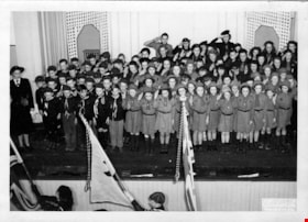
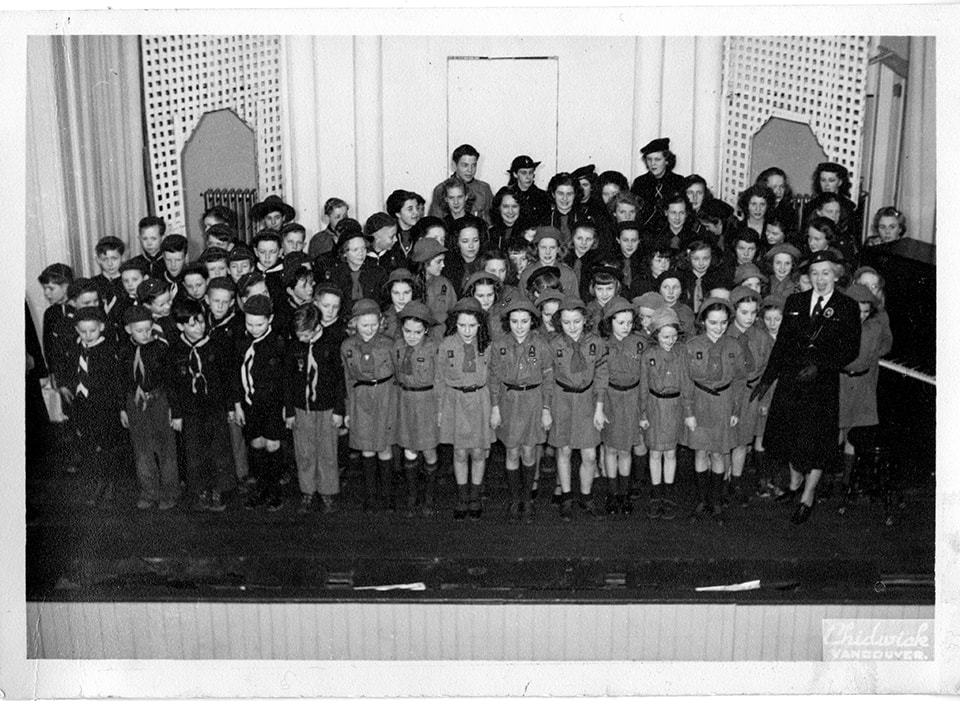
5th Burnaby Brownie concert
https://search.heritageburnaby.ca/link/museumdescription4825
- Repository
- Burnaby Village Museum
- Date
- 1948
- Collection/Fonds
- Burnaby Girl Guides fonds
- Description Level
- Item
- Physical Description
- 1 photograph : b&w ; 12.7 x 17.7 cm
- Scope and Content
- Photograph of 5th Burnaby Brownie Concert with 5th Burnaby Brownies, 5th Burnaby Guides, 1st North Burnaby Cubs and Scouts, Vancouver Sea Rangers, Brown Owl, Mrs. K. Hebron, Area Commissioner Miss R. McArthur, onstage at Gilmore Avenue School Auditorium.
- Repository
- Burnaby Village Museum
- Collection/Fonds
- Burnaby Girl Guides fonds
- Description Level
- Item
- Physical Description
- 1 photograph : b&w ; 12.7 x 17.7 cm
- Scope and Content
- Photograph of 5th Burnaby Brownie Concert with 5th Burnaby Brownies, 5th Burnaby Guides, 1st North Burnaby Cubs and Scouts, Vancouver Sea Rangers, Brown Owl, Mrs. K. Hebron, Area Commissioner Miss R. McArthur, onstage at Gilmore Avenue School Auditorium.
- Subjects
- Performances - Concerts
- Accession Code
- BV015.35.175
- Access Restriction
- No restrictions
- Reproduction Restriction
- No known restrictions
- Date
- 1948
- Media Type
- Photograph
- Scan Resolution
- 600
- Scan Date
- March 8, 2021
- Scale
- 100
- Notes
- Title based on contents of photograph
- This photograph is similar to photograph BV015.35.156.11 but includes people on the left side of the stage.
- Handwritten annotations above photograph reads: "5th Burnaby Brownie Concert with 5th Burnaby Brownies, 5th Burnaby Guides, 1st North Burnaby Cubs and Scouts, Vancouver Sea Rangers, Brown Owl, / Mrs. K. Hebron (below right), Area Commissioner Miss R. McArthur, onstage / at Gilmore Avenue School Auditorium...opening...Feb 25th"
- Photograph is a part of original scrapbook "5th Brownie Pack" 1948-1965 Item BV015.35.156
Images

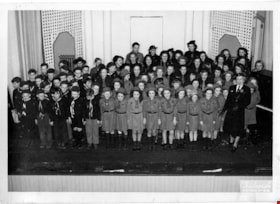
5th Burnaby Brownie concert
https://search.heritageburnaby.ca/link/museumdescription4826
- Repository
- Burnaby Village Museum
- Date
- 1948
- Collection/Fonds
- Burnaby Girl Guides fonds
- Description Level
- Item
- Physical Description
- 1 photograph : b&w ; 12.7 x 17.7 cm
- Scope and Content
- Photograph of 5th Burnaby Brownie Concert with 5th Burnaby Brownies, 5th Burnaby Guides, 1st North Burnaby Cubs and Scouts, Vancouver Sea Rangers, Brown Owl, Mrs. K. Hebron, Area Commissioner Miss R. McArthur, onstage at Gilmore Avenue School Auditorium.
- Repository
- Burnaby Village Museum
- Collection/Fonds
- Burnaby Girl Guides fonds
- Description Level
- Item
- Physical Description
- 1 photograph : b&w ; 12.7 x 17.7 cm
- Scope and Content
- Photograph of 5th Burnaby Brownie Concert with 5th Burnaby Brownies, 5th Burnaby Guides, 1st North Burnaby Cubs and Scouts, Vancouver Sea Rangers, Brown Owl, Mrs. K. Hebron, Area Commissioner Miss R. McArthur, onstage at Gilmore Avenue School Auditorium.
- Accession Code
- BV015.35.176
- Access Restriction
- No restrictions
- Reproduction Restriction
- No known restrictions
- Date
- 1948
- Media Type
- Photograph
- Scan Resolution
- 600
- Scan Date
- March 9, 2021
- Scale
- 100
- Notes
- Title based on contents of photograph
- This photograph is similar to photograph BV015.35.156.10 but includes people on the right side of the stage.
- Handwritten annotations above photograph reads: "5th Burnaby Brownie Concert with 5th Burnaby Brownies, 5th Burnaby Guides, 1st North Burnaby Cubs and Scouts, Vancouver Sea Rangers, Brown Owl, / Mrs. K. Hebron (below right), Area Commissioner Miss R. McArthur, onstage / at Gilmore Avenue School Auditorium...opening...Feb 25th"
- Photograph is a part of original scrapbook "5th Brownie Pack" 1948-1965 Item BV015.35.156
Images

5th Burnaby Brownie Pack scrapbook
https://search.heritageburnaby.ca/link/museumdescription4584
- Repository
- Burnaby Village Museum
- Date
- 1948-1965
- Collection/Fonds
- Burnaby Girl Guides fonds
- Description Level
- File
- Physical Description
- 1 scrapbook (2 digital files : (pdfs) + 58 photographs : col. (tiffs)) + 1 file of textual records + photographs + illustrations + ephemera
- Scope and Content
- File consists of images and original records from a scrapbook that was created by Mrs.M. Bate during her involvement with Burnaby Girl Guides. The original scrapbook is titled: "Scrapbook / Presented to / 5th Burnaby Brownie Pack / by Mrs. M. Bate / April 7th 1948" . The scrapbook contains 62 photo…
- Repository
- Burnaby Village Museum
- Collection/Fonds
- Burnaby Girl Guides fonds
- Description Level
- File
- Physical Description
- 1 scrapbook (2 digital files : (pdfs) + 58 photographs : col. (tiffs)) + 1 file of textual records + photographs + illustrations + ephemera
- Scope and Content
- File consists of images and original records from a scrapbook that was created by Mrs.M. Bate during her involvement with Burnaby Girl Guides. The original scrapbook is titled: "Scrapbook / Presented to / 5th Burnaby Brownie Pack / by Mrs. M. Bate / April 7th 1948" . The scrapbook contains 62 photographs, newspaper clippings, original artwork and memorabilia for 5th Brownie Pack; 1948 to 1965. Many of the photographs are described with notes on each page, some photographs refer to : a group photo of brownies and leaders gathered on April 7th, 1948 for the "Presentation of 3 Proficiency Badges and 17 Golden Bars" outside [St. Alban's church]; A Guide Rally at Hastings Auditorium; Sports Day events held at Stanley Park June 1948; Girl Guide parade floats for Community Day 1949 and 1950; Lady Baden-Powell in Vancouver ca. 1952; 3rd Brownie Pack Easter visit to Eatons; Christmas Party 1958 and a Gathering of Guides and Scouts on Burnaby Mountain [1961].Scrapbook also includes various awards, certificates, original artwork, correspondence and a pop up Christmas Card.
- Creator
- Bate, May
- Accession Code
- BV015.35.156
- Access Restriction
- No restrictions
- Reproduction Restriction
- May be restricted by third party rights
- Date
- 1948-1965
- Media Type
- Photograph
- Textual Record
- Notes
- Title based on contents of file
- Digital images were created of the scrapbook prior to selective retention of original records
- A selection of textual records have been retained under BV015.35.156
- A selection of photographs from scrapbook have been retained and some are described at item level (BV015.35.169 to BV015.35.188)
- Christmas card is described separately under BV015.35.332
Images

Documents
![21st Legislative Assembly of British Columbia, [between 1945 and 1948] thumbnail](/media/hpo/_Data/_BVM_Images/2020/2020_0031_0041_001.jpg?width=280)
21st Legislative Assembly of British Columbia
https://search.heritageburnaby.ca/link/museumdescription20318
- Repository
- Burnaby Village Museum
- Date
- [between 1945 and 1948]
- Collection/Fonds
- Joseph H.C. Corsbie fonds
- Description Level
- Item
- Physical Description
- 1 photograph : b&w print ; 28 x 39 cm mounted on matt board 30.5 x 41 cm
- Scope and Content
- Photograph of the "21st Legislative Assembly" portraits, 1945-1948. Members are identified in the top row left to right: J. Mowat; W.T. Straith K.C.; E.E. Winch; R.H. Carson; J.J. Gillis M.D.,C.M.; T. Uphill; T. King; L.Le Bourdais; S. Guthrie; L.H. Eyres; T.A. Love; second row left to right: Hon. …
- Repository
- Burnaby Village Museum
- Collection/Fonds
- Joseph H.C. Corsbie fonds
- Description Level
- Item
- Physical Description
- 1 photograph : b&w print ; 28 x 39 cm mounted on matt board 30.5 x 41 cm
- Scope and Content
- Photograph of the "21st Legislative Assembly" portraits, 1945-1948. Members are identified in the top row left to right: J. Mowat; W.T. Straith K.C.; E.E. Winch; R.H. Carson; J.J. Gillis M.D.,C.M.; T. Uphill; T. King; L.Le Bourdais; S. Guthrie; L.H. Eyres; T.A. Love; second row left to right: Hon. E.C. Carson; Hon. F. Putnam; Hon. G.S. Pearson; Hon. r.L Maitland K.C.; Hon. H. Hart Premier; H.E. Winch Leader of the Opposition; Hon. E.T. Kenney; Hon. H. Anscomb; Hon. G.M. Weir M.A.,d.Paed.; third row left to right: G.S. Wismer K.C.; H. Gargrave; F.W. Green M.D., C.M.; W.A.C. Bennett; Mrs. N. Hodges; Hon. N.w. Whittaker K.C.; Mrs. T.J. Rolston; R.C. MacDonald; A.J. Turner; B.I. Johnson; H.J. Welch; fourth row, left to right: J.H. Corsbie; W.D. Smith; E.F.Rowland; McIntyre E.C. (Law Clerk); W.R. Webster Capt. (Sgt.at arms); R.S. Yates (Clerk of House); A.J. McDonell; D.C. Brown; A.C. Hope; bottom row left to right: C.W. Morrow; R. Harding; A.B. Ritchie; C.T. Beard; R.R. Laird M.D., C.M.; J. McInnis; W.J. Johnson; J.H. Cates; J.L. Webster; W.H. Brett.
- Accession Code
- BV020.31.41
- Access Restriction
- No restrictions
- Reproduction Restriction
- No known restrictions
- Date
- [between 1945 and 1948]
- Media Type
- Photograph
- Scan Resolution
- 600
- Scan Date
- 19-09-2023
- Notes
- Title based on contents of photograph
- Signature of photographer in lower left corner of matt reads: "Philip Fort"
Images
![21st Legislative Assembly of British Columbia, [between 1945 and 1948] thumbnail](/media/hpo/_Data/_BVM_Images/2020/2020_0031_0041_001.jpg)
![50th Anniversary G.G.C., [1926-1979] thumbnail](/media/hpo/_Data/_BVM_Images/2015/2015_0035_0166_folded_redacted.jpg?width=280)
50th Anniversary G.G.C.
https://search.heritageburnaby.ca/link/museumdescription4594
- Repository
- Burnaby Village Museum
- Date
- [1926-1979]
- Collection/Fonds
- Burnaby Girl Guides fonds
- Description Level
- File
- Physical Description
- 1 scrapbook (51 photographs + 1 postcard + textual records)
- Scope and Content
- File consists of a scrapbook with a handpainted wood cover titled "50th Anniversary / G.G.C". The scrapbook documents events and ceremonies of the 4th Guide Company with the first half of the scrapbook containing photographs and documents regarding the 50th Anniversary of Girl Guides which was cele…
- Repository
- Burnaby Village Museum
- Collection/Fonds
- Burnaby Girl Guides fonds
- Description Level
- File
- Physical Description
- 1 scrapbook (51 photographs + 1 postcard + textual records)
- Scope and Content
- File consists of a scrapbook with a handpainted wood cover titled "50th Anniversary / G.G.C". The scrapbook documents events and ceremonies of the 4th Guide Company with the first half of the scrapbook containing photographs and documents regarding the 50th Anniversary of Girl Guides which was celebrated at St. Nicholas Church in 1960 while the second half documents earlier events from 1926, as well as other events in the 1960s such as; "Year of the Golden Jubilee", a parade in North Burnaby as well as Thinking Day 1976-1978, banquets, a disco contest, camping on Hollyburn mountain and a visit to Victoria in 1979. On November 3rd, 1926 the company was registered as the 5th Burnaby Guide company, in 1951 the number was changed to the 4th Vancouver Guide Company and in 1956 the number was changed to the 4th Burnaby Company.
- Accession Code
- BV015.35.166
- Access Restriction
- No restrictions
- Reproduction Restriction
- May be restricted by third party rights
- Date
- [1926-1979]
- Media Type
- Textual Record
- Photograph
- Notes
- Transcribed title
- Items within scrapbook have been redacted in compliance with Section 22 of FIPPA
- A selection of photographs are described at item level (BV015.35.285 to BV.015.35.300).
Images
![50th Anniversary G.G.C., [1926-1979] thumbnail](/media/hpo/_Data/_BVM_Images/2015/2015_0035_0166_folded_redacted.jpg)
Documents
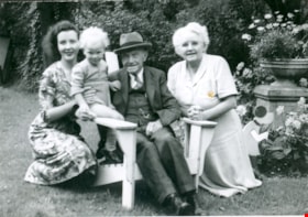
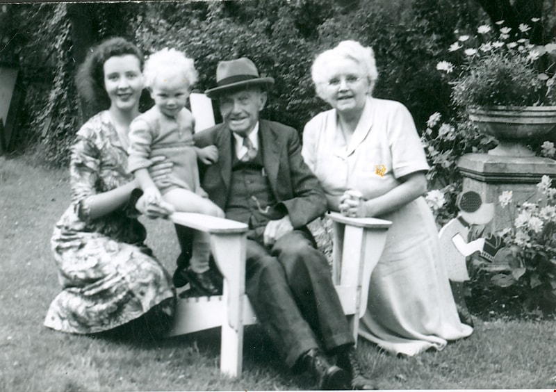
90th Birthday of Edwin Wettenhall Bateman
https://search.heritageburnaby.ca/link/museumdescription912
- Repository
- Burnaby Village Museum
- Date
- 1949
- Collection/Fonds
- E.W. Bateman family fonds
- Description Level
- Item
- Physical Description
- 1 photograph : b&w ; 7.1 x 11.4 cm
- Scope and Content
- Photograph representing four generations, taken on Edwin W. Bateman's 90th birthday. Pictured are, Mr. Bateman's daughter, Edna Bateman Corner (right), her daughter, Catherine Corner Levins and her son. The photograph was taken outside, possibly in a garden. Mr. Bateman lived at "Elworth," 6501 De…
- Repository
- Burnaby Village Museum
- Collection/Fonds
- E.W. Bateman family fonds
- Description Level
- Item
- Physical Description
- 1 photograph : b&w ; 7.1 x 11.4 cm
- Material Details
- inscribed in pencil, verso, t.
- Scope and Content
- Photograph representing four generations, taken on Edwin W. Bateman's 90th birthday. Pictured are, Mr. Bateman's daughter, Edna Bateman Corner (right), her daughter, Catherine Corner Levins and her son. The photograph was taken outside, possibly in a garden. Mr. Bateman lived at "Elworth," 6501 Deer Lake Avenue, which was designated a heritage property in 1992; however, the location of this photograph is not identified.
- Subjects
- Celebrations - Birthdays
- Accession Code
- HV974.22.2
- Access Restriction
- No restrictions
- Reproduction Restriction
- No known restrictions
- Date
- 1949
- Media Type
- Photograph
- Related Material
- Earlier catalogue record indicates that there is more information on the Bateman Family in the BVM archives.
- Scan Resolution
- 600
- Scan Date
- 2023-04-25
- Notes
- Title based on contents of photograph
- An annotation on the back of the photograph reads, "4 Generations / 1949 / Grandpa Batemans / 90th birthday"
Images
![202 Delta Avenue lot, [1945 or 1946] (date of original), copied 1991 thumbnail](/media/hpo/_Data/_Archives_Images/_Unrestricted/370/370-225.jpg?width=280)
202 Delta Avenue lot
https://search.heritageburnaby.ca/link/archivedescription37637
- Repository
- City of Burnaby Archives
- Date
- [1945 or 1946] (date of original), copied 1991
- Collection/Fonds
- Burnaby Historical Society fonds
- Description Level
- Item
- Physical Description
- 1 photograph : b&w ; 3.2 x 5.3 cm print on contact sheet 20.2 x 25.3 cm
- Scope and Content
- Photograph of a mound of earth on the 202 Delta Avenue lot, with 142 Delta Avenue visible in the background. The photograph was taken facing northeast.
- Repository
- City of Burnaby Archives
- Date
- [1945 or 1946] (date of original), copied 1991
- Collection/Fonds
- Burnaby Historical Society fonds
- Subseries
- Burnaby Image Bank subseries
- Physical Description
- 1 photograph : b&w ; 3.2 x 5.3 cm print on contact sheet 20.2 x 25.3 cm
- Description Level
- Item
- Record No.
- 370-225
- Access Restriction
- No restrictions
- Reproduction Restriction
- No known restrictions
- Accession Number
- BHS1999-03
- Scope and Content
- Photograph of a mound of earth on the 202 Delta Avenue lot, with 142 Delta Avenue visible in the background. The photograph was taken facing northeast.
- Subjects
- Construction
- Media Type
- Photograph
- Notes
- Title based on contents of photograph
- 1 b&w copy negative accompanying
- Geographic Access
- Delta Avenue
- Street Address
- 202 Delta Avenue
- Historic Neighbourhood
- Capitol Hill (Historic Neighbourhood)
- Planning Study Area
- Capitol Hill Area
Images
![202 Delta Avenue lot, [1945 or 1946] (date of original), copied 1991 thumbnail](/media/hpo/_Data/_Archives_Images/_Unrestricted/370/370-225.jpg)
![202 Delta Avenue under construction, [1948] (date of original), copied 1991 thumbnail](/media/hpo/_Data/_Archives_Images/_Unrestricted/370/370-226.jpg?width=280)
202 Delta Avenue under construction
https://search.heritageburnaby.ca/link/archivedescription37638
- Repository
- City of Burnaby Archives
- Date
- [1948] (date of original), copied 1991
- Collection/Fonds
- Burnaby Historical Society fonds
- Description Level
- Item
- Physical Description
- 1 photograph : b&w ; 3.2 x 5.3 cm print on contact sheet 20.2 x 25.3 cm
- Scope and Content
- Photograph of the house at 202 Delta Avenue under construction.
- Repository
- City of Burnaby Archives
- Date
- [1948] (date of original), copied 1991
- Collection/Fonds
- Burnaby Historical Society fonds
- Subseries
- Burnaby Image Bank subseries
- Physical Description
- 1 photograph : b&w ; 3.2 x 5.3 cm print on contact sheet 20.2 x 25.3 cm
- Description Level
- Item
- Record No.
- 370-226
- Access Restriction
- No restrictions
- Reproduction Restriction
- No known restrictions
- Accession Number
- BHS1999-03
- Scope and Content
- Photograph of the house at 202 Delta Avenue under construction.
- Media Type
- Photograph
- Notes
- Title based on contents of photograph
- 1 b&w copy negative accompanying
- Geographic Access
- Delta Avenue
- Street Address
- 202 Delta Avenue
- Historic Neighbourhood
- Capitol Hill (Historic Neighbourhood)
- Planning Study Area
- Capitol Hill Area
Images
![202 Delta Avenue under construction, [1948] (date of original), copied 1991 thumbnail](/media/hpo/_Data/_Archives_Images/_Unrestricted/370/370-226.jpg)
![202 Delta Avenue under construction, [1949] (date of original), copied 1991 thumbnail](/media/hpo/_Data/_Archives_Images/_Unrestricted/370/370-227.jpg?width=280)
202 Delta Avenue under construction
https://search.heritageburnaby.ca/link/archivedescription37639
- Repository
- City of Burnaby Archives
- Date
- [1949] (date of original), copied 1991
- Collection/Fonds
- Burnaby Historical Society fonds
- Description Level
- Item
- Physical Description
- 1 photograph : b&w ; 3.2 x 5.3 cm print on contact sheet 20.2 x 25.3 cm
- Scope and Content
- Photograph of the house at 202 Delta Avenue under construction.
- Repository
- City of Burnaby Archives
- Date
- [1949] (date of original), copied 1991
- Collection/Fonds
- Burnaby Historical Society fonds
- Subseries
- Burnaby Image Bank subseries
- Physical Description
- 1 photograph : b&w ; 3.2 x 5.3 cm print on contact sheet 20.2 x 25.3 cm
- Description Level
- Item
- Record No.
- 370-227
- Access Restriction
- No restrictions
- Reproduction Restriction
- No restrictions
- Accession Number
- BHS1999-03
- Scope and Content
- Photograph of the house at 202 Delta Avenue under construction.
- Media Type
- Photograph
- Notes
- Title based on contents of photograph
- 1 b&w copy negative accompanying
- Geographic Access
- Delta Avenue
- Street Address
- 202 Delta Avenue
- Historic Neighbourhood
- Capitol Hill (Historic Neighbourhood)
- Planning Study Area
- Capitol Hill Area
Images
![202 Delta Avenue under construction, [1949] (date of original), copied 1991 thumbnail](/media/hpo/_Data/_Archives_Images/_Unrestricted/370/370-227.jpg)
![311 Madison Avenue, [1949 or 1950] (date of original), copied 1991 thumbnail](/media/hpo/_Data/_Archives_Images/_Unrestricted/370/370-204.jpg?width=280)
311 Madison Avenue
https://search.heritageburnaby.ca/link/archivedescription37616
- Repository
- City of Burnaby Archives
- Date
- [1949 or 1950] (date of original), copied 1991
- Collection/Fonds
- Burnaby Historical Society fonds
- Description Level
- Item
- Physical Description
- 1 photograph : b&w ; 3.0 x 4.5 cm print on contact sheet 20.2 x 25.3 cm
- Scope and Content
- Photograph of a side view of 311 Madison Avenue, in the snow. The photograph was taken from Madison Avenue.
- Repository
- City of Burnaby Archives
- Date
- [1949 or 1950] (date of original), copied 1991
- Collection/Fonds
- Burnaby Historical Society fonds
- Subseries
- Burnaby Image Bank subseries
- Physical Description
- 1 photograph : b&w ; 3.0 x 4.5 cm print on contact sheet 20.2 x 25.3 cm
- Description Level
- Item
- Record No.
- 370-204
- Access Restriction
- No restrictions
- Reproduction Restriction
- No restrictions
- Accession Number
- BHS1999-03
- Scope and Content
- Photograph of a side view of 311 Madison Avenue, in the snow. The photograph was taken from Madison Avenue.
- Media Type
- Photograph
- Notes
- Title based on contents of photograph
- 1 b&w copy negative accompanying
- Geographic Access
- Madison Avenue
- Street Address
- 311 Madison Avenue
- Historic Neighbourhood
- Vancouver Heights (Historic Neighbourhood)
- Planning Study Area
- Burnaby Heights Area
Images
![311 Madison Avenue, [1949 or 1950] (date of original), copied 1991 thumbnail](/media/hpo/_Data/_Archives_Images/_Unrestricted/370/370-204.jpg)
![311 Madison Avenue, [1941] (date of original), copied 1991 thumbnail](/media/hpo/_Data/_Archives_Images/_Unrestricted/370/370-205.jpg?width=280)
311 Madison Avenue
https://search.heritageburnaby.ca/link/archivedescription37617
- Repository
- City of Burnaby Archives
- Date
- [1941] (date of original), copied 1991
- Collection/Fonds
- Burnaby Historical Society fonds
- Description Level
- Item
- Physical Description
- 1 photograph : b&w ; 4.5 x 3.1 cm print on contact sheet 20.2 x 25.3 cm
- Scope and Content
- Photograph of the front of 311 Madison Avenue, taken from across the street.
- Repository
- City of Burnaby Archives
- Date
- [1941] (date of original), copied 1991
- Collection/Fonds
- Burnaby Historical Society fonds
- Subseries
- Burnaby Image Bank subseries
- Physical Description
- 1 photograph : b&w ; 4.5 x 3.1 cm print on contact sheet 20.2 x 25.3 cm
- Description Level
- Item
- Record No.
- 370-205
- Access Restriction
- No restrictions
- Reproduction Restriction
- No known restrictions
- Accession Number
- BHS1999-03
- Scope and Content
- Photograph of the front of 311 Madison Avenue, taken from across the street.
- Subjects
- Buildings - Residential - Houses
- Media Type
- Photograph
- Notes
- Title based on contents of photograph
- 1 b&w copy negative accompanying
- Geographic Access
- Madison Avenue
- Street Address
- 311 Madison Avenue
- Historic Neighbourhood
- Vancouver Heights (Historic Neighbourhood)
- Planning Study Area
- Burnaby Heights Area
Images
![311 Madison Avenue, [1941] (date of original), copied 1991 thumbnail](/media/hpo/_Data/_Archives_Images/_Unrestricted/370/370-205.jpg)
![1007 Gilley Avenue, [1949 or 1950] (date of original), copied 1991 thumbnail](/media/hpo/_Data/_Archives_Images/_Unrestricted/370/370-667.jpg?width=280)
1007 Gilley Avenue
https://search.heritageburnaby.ca/link/archivedescription38080
- Repository
- City of Burnaby Archives
- Date
- [1949 or 1950] (date of original), copied 1991
- Collection/Fonds
- Burnaby Historical Society fonds
- Description Level
- Item
- Physical Description
- 1 photograph : b&w ; 3.0 x 3.0 cm print on contact sheet 20.2 x 26.2 cm
- Scope and Content
- Photograph of the back of 1007 Gilley Avenue (later renumbered 8416 Gilley Avenue).
- Repository
- City of Burnaby Archives
- Date
- [1949 or 1950] (date of original), copied 1991
- Collection/Fonds
- Burnaby Historical Society fonds
- Subseries
- Burnaby Image Bank subseries
- Physical Description
- 1 photograph : b&w ; 3.0 x 3.0 cm print on contact sheet 20.2 x 26.2 cm
- Description Level
- Item
- Record No.
- 370-667
- Access Restriction
- No restrictions
- Reproduction Restriction
- No restrictions
- Accession Number
- BHS1999-03
- Scope and Content
- Photograph of the back of 1007 Gilley Avenue (later renumbered 8416 Gilley Avenue).
- Subjects
- Buildings - Residential - Houses
- Media Type
- Photograph
- Notes
- Title based on contents of photograph
- 1 b&w copy negative accompanying
- Negative has a pink cast
- Geographic Access
- Gilley Avenue
- Street Address
- 8416 Gilley Avenue
- Planning Study Area
- Stride Hill Area
Images
![1007 Gilley Avenue, [1949 or 1950] (date of original), copied 1991 thumbnail](/media/hpo/_Data/_Archives_Images/_Unrestricted/370/370-667.jpg)
![1796 1st Street, [1940] (date of original), copied 1991 thumbnail](/media/hpo/_Data/_Archives_Images/_Unrestricted/370/370-265.jpg?width=280)
1796 1st Street
https://search.heritageburnaby.ca/link/archivedescription37677
- Repository
- City of Burnaby Archives
- Date
- [1940] (date of original), copied 1991
- Collection/Fonds
- Burnaby Historical Society fonds
- Description Level
- Item
- Physical Description
- 1 photograph : b&w ; 3.9 x 2.3 cm print on contact sheet 20.2 x 25.3 cm
- Scope and Content
- Photograph of the back view of 1796 1st Street taken from a distance (later renumbered 7419 1st Street). The house was built before 1918.
- Repository
- City of Burnaby Archives
- Date
- [1940] (date of original), copied 1991
- Collection/Fonds
- Burnaby Historical Society fonds
- Subseries
- Burnaby Image Bank subseries
- Physical Description
- 1 photograph : b&w ; 3.9 x 2.3 cm print on contact sheet 20.2 x 25.3 cm
- Description Level
- Item
- Record No.
- 370-265
- Access Restriction
- No restrictions
- Reproduction Restriction
- No known restrictions
- Accession Number
- BHS1999-03
- Scope and Content
- Photograph of the back view of 1796 1st Street taken from a distance (later renumbered 7419 1st Street). The house was built before 1918.
- Subjects
- Buildings - Residential - Houses
- Media Type
- Photograph
- Notes
- Title based on contents of photograph
- 1 b&w copy negative accompanying
- Negative has a pink cast
- Geographic Access
- 1st Street
- Street Address
- 7149 1st Street
- Historic Neighbourhood
- East Burnaby (Historic Neighbourhood)
- Planning Study Area
- Second Street Area
Images
![1796 1st Street, [1940] (date of original), copied 1991 thumbnail](/media/hpo/_Data/_Archives_Images/_Unrestricted/370/370-265.jpg)