More like 'Interview with Jack Davy and Thomas James Sanderson 22-Jul-75 - Track 1'
Narrow Results By
Subject
- Accidents 1
- Accidents - Automobile Accidents 1
- Advertising Medium - Signs and Signboards 36
- Aerial Photographs 36
- Agricultural Tools and Equipment 2
- Agricultural Tools and Equipment - Gardening Equipment 4
- Agricultural Tools and Equipment - Plows 2
- Agriculture 3
- Agriculture - Farms 11
- Agriculture - Fruit and Berries 1
- Animals 4
- Animals - Birds 28
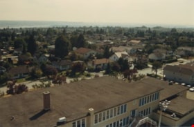
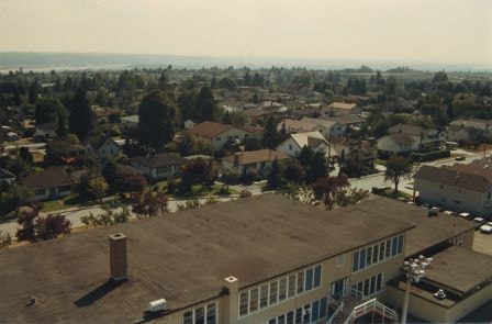
Edmonds school rooftop
https://search.heritageburnaby.ca/link/archivedescription35959
- Repository
- City of Burnaby Archives
- Date
- December 1987
- Collection/Fonds
- Burnaby Historical Society fonds
- Description Level
- Item
- Physical Description
- 1 photograph : col. ; 10 x 15 cm
- Scope and Content
- Photograph was taken looking south-west from a fire ladder above Edmonds Street School, with the school's rooftop as well as its surounding neighbourhood visible.
- Repository
- City of Burnaby Archives
- Date
- December 1987
- Collection/Fonds
- Burnaby Historical Society fonds
- Subseries
- Edmonds School subseries
- Physical Description
- 1 photograph : col. ; 10 x 15 cm
- Description Level
- Item
- Record No.
- 207-008
- Access Restriction
- No restrictions
- Reproduction Restriction
- Reproduce for fair dealing purposes only
- Accession Number
- BHS1988-07
- Scope and Content
- Photograph was taken looking south-west from a fire ladder above Edmonds Street School, with the school's rooftop as well as its surounding neighbourhood visible.
- Subjects
- Geographic Features - Neighbourhoods
- Names
- Edmonds Community School
- Media Type
- Photograph
- Notes
- Title based on contents of photograph
- Geographic Access
- 18th Avenue
- Street Address
- 7651 18th Avenue
- Historic Neighbourhood
- Edmonds (Historic Neighbourhood)
- Planning Study Area
- Edmonds Area
Images
![Hats Off Day, [2001] thumbnail](/media/hpo/_Data/_Archives_Images/_Unrestricted/535/535-3391-5.jpg?width=280)
Hats Off Day
https://search.heritageburnaby.ca/link/archivedescription98381
- Repository
- City of Burnaby Archives
- Date
- [2001]
- Collection/Fonds
- Burnaby NewsLeader photograph collection
- Description Level
- File
- Physical Description
- 10 photographs (tiff) : col.
- Scope and Content
- File contains photographs of the 2001 Hats Off Day parade and event in the Burnaby Heights neighbourhood. Photographs depict performers (including clowns, a town crier, a fire juggler, and tap dancers) in the parade; children and adults enjoying the parade and events; and business owners and volunt…
- Repository
- City of Burnaby Archives
- Date
- [2001]
- Collection/Fonds
- Burnaby NewsLeader photograph collection
- Physical Description
- 10 photographs (tiff) : col.
- Description Level
- File
- Record No.
- 535-3391
- Access Restriction
- No restrictions
- Reproduction Restriction
- No restrictions
- Accession Number
- 2018-12
- Scope and Content
- File contains photographs of the 2001 Hats Off Day parade and event in the Burnaby Heights neighbourhood. Photographs depict performers (including clowns, a town crier, a fire juggler, and tap dancers) in the parade; children and adults enjoying the parade and events; and business owners and volunteers prepping food and dealing with the rainy weather.
- Subjects
- Events
- Events - Parades
- Geographic Features - Neighbourhoods
- Performances
- Persons - Children
- Persons - Crowds
- Media Type
- Photograph
- Notes
- Title based on caption
- Collected by editorial for use in a June 2001 issue of the Burnaby NewsLeader
- Caption from metadata for 535-3391-1: "Kelvin Yee drains the rainwater from the awning in front of the New Rainbow Cafe."
- Caption from metadata for 535-3391-2: "It's hard to stay a happy clown when you're trying to pedal your decorated bike in a rainstorm, as Corey Barker, 8, discovered at Saturday's Hats Off Day parade."
- Caption from metadata for 535-3391-3: "Even the town crier struggled to stay dry during one of the many downpours that rained on Saturday's Hats Off Day parade."
- Caption from metadata for 535-3391-4: "A member of the Confederation Tap Dancers tries to dance up some sunshine at Saturday's Hats Off Day parade."
- Caption from metadata for 535-3391-5: "Devin Schellenberg amazes and delights spectators with his fire juggling at Saturday's Hats Off Day festival."
- Caption from metadata for 535-3391-6: "Ashley Boston, 4, plays in the soap bubbles that appeared at the Heights Fountain Square during Saturday's Hats Off Day festival on Hastings St."
- Caption from metadata for 535-3391-7: "The Hats Off Day parade is all about hats."
- Caption from metadata for 535-3391-8: "Stuart Wells enjoys a salmon kabob outside the Pear Tree Restaurant, some of diverse food being offered by restaurants and delis along Hastings St. as part of Hats Off Day."
- Caption from metadata for 535-3391-9: "George Kopf and Cynthia Chow, of the Footlight Theatre Company, fuel up at the Lions Club pancake breakfast before marching in Saturday's Hats Off Day parade. Kirk Dickson is flipping the pancakes."
- Caption from metadata for 535-3391-10: "Yusef Sulayman, 5, and his sister, Sevda, 6, try to stay dry as they watch Saturday's Hats Off Day parade."
- Geographic Access
- Hastings Street
- Historic Neighbourhood
- Vancouver Heights (Historic Neighbourhood)
- Planning Study Area
- Burnaby Heights Area
Images
![Hats Off Day, [2001] thumbnail](/media/hpo/_Data/_Archives_Images/_Unrestricted/535/535-3391-5.jpg)
![Herman Peterson, [2000] thumbnail](/media/hpo/_Data/_Archives_Images/_Unrestricted/535/535-2706.jpg?width=280)
Herman Peterson
https://search.heritageburnaby.ca/link/archivedescription97310
- Repository
- City of Burnaby Archives
- Date
- [2000]
- Collection/Fonds
- Burnaby NewsLeader photograph collection
- Description Level
- Item
- Physical Description
- 1 photograph (tiff) : col.
- Scope and Content
- Photograph of Herman Peterson posing with a handheld video camera in front of a residential home.
- Repository
- City of Burnaby Archives
- Date
- [2000]
- Collection/Fonds
- Burnaby NewsLeader photograph collection
- Physical Description
- 1 photograph (tiff) : col.
- Description Level
- Item
- Record No.
- 535-2706
- Access Restriction
- No restrictions
- Reproduction Restriction
- Reproduce for fair dealing purposes only
- Accession Number
- 2018-12
- Scope and Content
- Photograph of Herman Peterson posing with a handheld video camera in front of a residential home.
- Media Type
- Photograph
- Photographer
- Bartel, Mario
- Notes
- Title based on caption
- Collected by editorial for use in a September 2000 issue of the Burnaby NewsLeader
- Caption from metadata: "Herman Peterson used his video camera to tape the comings and goings of a suspected crack house in his neighborhood, helping police take steps to shut it down."
Images
![Herman Peterson, [2000] thumbnail](/media/hpo/_Data/_Archives_Images/_Unrestricted/535/535-2706.jpg)
![In the neighbourhood, [194-] (date of original), copied 1976 thumbnail](/media/hpo/_Data/_BVM_Images/1974/197602510030.jpg?width=280)
In the neighbourhood
https://search.heritageburnaby.ca/link/museumdescription1625
- Repository
- Burnaby Village Museum
- Date
- [194-] (date of original), copied 1976
- Collection/Fonds
- Burnaby Village Museum Photograph collection
- Description Level
- Item
- Physical Description
- 1 photograph : col. negative ; 4.5 x 6.5 cm
- Scope and Content
- Photograph of an elderly woman standing on a pavement sidewalk beside Regent Street. The tall house in the background is the McCallum house facing Regent Street, and other houses on the right side facing the road. There is an unpaved footpath closer to the houses. Electric poles are erected along t…
- Repository
- Burnaby Village Museum
- Collection/Fonds
- Burnaby Village Museum Photograph collection
- Description Level
- Item
- Physical Description
- 1 photograph : col. negative ; 4.5 x 6.5 cm
- Scope and Content
- Photograph of an elderly woman standing on a pavement sidewalk beside Regent Street. The tall house in the background is the McCallum house facing Regent Street, and other houses on the right side facing the road. There is an unpaved footpath closer to the houses. Electric poles are erected along the road on a grassy patch between the pavement sidewalk and the foot path.
- Subjects
- Geographic Features - Neighbourhoods
- Accession Code
- HV976.251.30
- Access Restriction
- No restrictions
- Reproduction Restriction
- May be restricted by third party rights
- Date
- [194-] (date of original), copied 1976
- Media Type
- Photograph
- Related Material
- For another photograph of the elderly lady, see HV976.251.28
- Scan Resolution
- 300
- Scan Date
- 22/8/2006
- Scale
- 100
- Notes
- Title based on contents of photograph
- The print is made as a black and white print from a colour negative film
Images
![In the neighbourhood, [194-] (date of original), copied 1976 thumbnail](/media/hpo/_Data/_BVM_Images/1974/197602510030.jpg)
![North Burnaby from Hythe Avenue, [1949] thumbnail](/media/hpo/_Data/_Archives_Images/_Unrestricted/126/161-004.jpg?width=280)
North Burnaby from Hythe Avenue
https://search.heritageburnaby.ca/link/archivedescription34929
- Repository
- City of Burnaby Archives
- Date
- [1949]
- Collection/Fonds
- Burnaby Historical Society fonds
- Description Level
- Item
- Physical Description
- 1 photograph : b&w ; 9.1 x 12.6 cm
- Scope and Content
- Photograph taken looking west from Hythe Avenue, between Empire Drive and Dundas, towards north Burnaby.
- Repository
- City of Burnaby Archives
- Date
- [1949]
- Collection/Fonds
- Burnaby Historical Society fonds
- Subseries
- Marjorie Coe subseries
- Physical Description
- 1 photograph : b&w ; 9.1 x 12.6 cm
- Description Level
- Item
- Record No.
- 161-004
- Access Restriction
- No restrictions
- Reproduction Restriction
- Reproduce for fair dealing purposes only
- Accession Number
- BHS1986-11
- Scope and Content
- Photograph taken looking west from Hythe Avenue, between Empire Drive and Dundas, towards north Burnaby.
- Subjects
- Geographic Features - Neighbourhoods
- Media Type
- Photograph
- Notes
- Title based on contents of photograph
- Item no. 161-004, 161-005 and 161-006 join to form a panorama
- Geographic Access
- Hythe Avenue
- Historic Neighbourhood
- Capitol Hill (Historic Neighbourhood)
- Planning Study Area
- Capitol Hill Area
Images
![North Burnaby from Hythe Avenue, [1949] thumbnail](/media/hpo/_Data/_Archives_Images/_Unrestricted/126/161-004.jpg)
![North Burnaby from Hythe Avenue, [1949] thumbnail](/media/hpo/_Data/_Archives_Images/_Unrestricted/126/161-005.jpg?width=280)
North Burnaby from Hythe Avenue
https://search.heritageburnaby.ca/link/archivedescription34930
- Repository
- City of Burnaby Archives
- Date
- [1949]
- Collection/Fonds
- Burnaby Historical Society fonds
- Description Level
- Item
- Physical Description
- 1 photograph : b&w ; 8.9 x 12.6 cm
- Scope and Content
- Photograph taken looking west from Hythe Avenue towards north Burnaby.
- Repository
- City of Burnaby Archives
- Date
- [1949]
- Collection/Fonds
- Burnaby Historical Society fonds
- Subseries
- Marjorie Coe subseries
- Physical Description
- 1 photograph : b&w ; 8.9 x 12.6 cm
- Description Level
- Item
- Record No.
- 161-005
- Access Restriction
- No restrictions
- Reproduction Restriction
- Reproduce for fair dealing purposes only
- Accession Number
- BHS1986-11
- Scope and Content
- Photograph taken looking west from Hythe Avenue towards north Burnaby.
- Subjects
- Geographic Features - Neighbourhoods
- Media Type
- Photograph
- Notes
- Title based on contents of photograph
- Items no. 161-004, 161-005 and 161-006 join to form a panorama
- Geographic Access
- Hythe Avenue
- Historic Neighbourhood
- Capitol Hill (Historic Neighbourhood)
- Planning Study Area
- Capitol Hill Area
Images
![North Burnaby from Hythe Avenue, [1949] thumbnail](/media/hpo/_Data/_Archives_Images/_Unrestricted/126/161-005.jpg)
![North Burnaby neighbourhood traffic, [2002] thumbnail](/media/hpo/_Data/_Archives_Images/_Unrestricted/535/535-2834.jpg?width=280)
North Burnaby neighbourhood traffic
https://search.heritageburnaby.ca/link/archivedescription97495
- Repository
- City of Burnaby Archives
- Date
- [2002]
- Collection/Fonds
- Burnaby NewsLeader photograph collection
- Description Level
- Item
- Physical Description
- 1 photograph (tiff) : col.
- Scope and Content
- Photograph of Glen Webb and Megan Perry standing on a residential street in their North Burnaby neighbourhood. A car is driving up the hill, and the Vancouver skyline is visible in the distance.
- Repository
- City of Burnaby Archives
- Date
- [2002]
- Collection/Fonds
- Burnaby NewsLeader photograph collection
- Physical Description
- 1 photograph (tiff) : col.
- Description Level
- Item
- Record No.
- 535-2834
- Access Restriction
- No restrictions
- Reproduction Restriction
- No restrictions
- Accession Number
- 2018-12
- Scope and Content
- Photograph of Glen Webb and Megan Perry standing on a residential street in their North Burnaby neighbourhood. A car is driving up the hill, and the Vancouver skyline is visible in the distance.
- Media Type
- Photograph
- Photographer
- Bartel, Mario
- Notes
- Title based on caption
- Collected by editorial for use in an October 2002 issue of the Burnaby NewsLeader
- Caption from metadata: "Glen Webb and Megan Perry say their neighborhood in North Burnaby is fed up with commuters cutting along their residential streets as they try to avoid rush hour congestion along Hastings St."
- Historic Neighbourhood
- Capitol Hill (Historic Neighbourhood)
- Planning Study Area
- Capitol Hill Area
Images
![North Burnaby neighbourhood traffic, [2002] thumbnail](/media/hpo/_Data/_Archives_Images/_Unrestricted/535/535-2834.jpg)
![Person talking to Metrotown police, [1999] thumbnail](/media/hpo/_Data/_Archives_Images/_Unrestricted/535/535-3389.jpg?width=280)
Person talking to Metrotown police
https://search.heritageburnaby.ca/link/archivedescription98379
- Repository
- City of Burnaby Archives
- Date
- [1999]
- Collection/Fonds
- Burnaby NewsLeader photograph collection
- Description Level
- Item
- Physical Description
- 1 photograph (tiff) : col.
- Scope and Content
- Photograph of an unidentified person speaking to an unidentified Burnaby RCMP officer in the Metrotown area. Two towers and the SkyTrain tracks are visible behind the two people.
- Repository
- City of Burnaby Archives
- Date
- [1999]
- Collection/Fonds
- Burnaby NewsLeader photograph collection
- Physical Description
- 1 photograph (tiff) : col.
- Description Level
- Item
- Record No.
- 535-3389
- Access Restriction
- No restrictions
- Reproduction Restriction
- No restrictions
- Accession Number
- 2018-12
- Scope and Content
- Photograph of an unidentified person speaking to an unidentified Burnaby RCMP officer in the Metrotown area. Two towers and the SkyTrain tracks are visible behind the two people.
- Media Type
- Photograph
- Notes
- Title based on original file name
- Collected by editorial for use in an October 1999 issue of the Burnaby NewsLeader
- Historic Neighbourhood
- Central Park (Historic Neighbourhood)
- Planning Study Area
- Maywood Area
Images
![Person talking to Metrotown police, [1999] thumbnail](/media/hpo/_Data/_Archives_Images/_Unrestricted/535/535-3389.jpg)
![Person viewing large knives in the Metrotown area, [1999] thumbnail](/media/hpo/_Data/_Archives_Images/_Unrestricted/535/535-3387.jpg?width=280)
Person viewing large knives in the Metrotown area
https://search.heritageburnaby.ca/link/archivedescription98377
- Repository
- City of Burnaby Archives
- Date
- [1999]
- Collection/Fonds
- Burnaby NewsLeader photograph collection
- Description Level
- Item
- Physical Description
- 1 photograph (tiff) : col.
- Scope and Content
- Photograph of an unidentified person viewing two large knives and a pole laying across a garbage can in the Metrotown area. Two towers and the SkyTrain tracks are visible behind the person.
- Repository
- City of Burnaby Archives
- Date
- [1999]
- Collection/Fonds
- Burnaby NewsLeader photograph collection
- Physical Description
- 1 photograph (tiff) : col.
- Description Level
- Item
- Record No.
- 535-3387
- Access Restriction
- No restrictions
- Reproduction Restriction
- No restrictions
- Accession Number
- 2018-12
- Scope and Content
- Photograph of an unidentified person viewing two large knives and a pole laying across a garbage can in the Metrotown area. Two towers and the SkyTrain tracks are visible behind the person.
- Names
- Metrotown
- Media Type
- Photograph
- Notes
- Title based on contents of photograph
- Collected by editorial for use in an October 1999 issue of the Burnaby NewsLeader
- Historic Neighbourhood
- Central Park (Historic Neighbourhood)
- Planning Study Area
- Maywood Area
Images
![Person viewing large knives in the Metrotown area, [1999] thumbnail](/media/hpo/_Data/_Archives_Images/_Unrestricted/535/535-3387.jpg)
![Resident of Edmonds area, [2004] thumbnail](/media/hpo/_Data/_Archives_Images/_Unrestricted/535/535-2082.jpg?width=280)
Resident of Edmonds area
https://search.heritageburnaby.ca/link/archivedescription96412
- Repository
- City of Burnaby Archives
- Date
- [2004]
- Collection/Fonds
- Burnaby NewsLeader photograph collection
- Description Level
- Item
- Physical Description
- 1 photograph (tiff) : col.
- Scope and Content
- Photograph of a person peering through the blinds of a home near Ernie Winch Park.
- Repository
- City of Burnaby Archives
- Date
- [2004]
- Collection/Fonds
- Burnaby NewsLeader photograph collection
- Physical Description
- 1 photograph (tiff) : col.
- Description Level
- Item
- Record No.
- 535-2082
- Access Restriction
- No restrictions
- Reproduction Restriction
- No restrictions
- Accession Number
- 2018-12
- Scope and Content
- Photograph of a person peering through the blinds of a home near Ernie Winch Park.
- Media Type
- Photograph
- Photographer
- Bartel, Mario
- Notes
- Title based on caption
- Collected by editorial for use in a March 2004 issue of the Burnaby NewsLeader
- Caption from metadata: "Residents near Ernie Winch Park, in Burnaby's Edmonds area, say they feel like prisoners in their own homes because of the prostitution and drug trade in their neighbourhood."
- Geographic Access
- Ernie Winch Park
- Planning Study Area
- Edmonds Area
Images
![Resident of Edmonds area, [2004] thumbnail](/media/hpo/_Data/_Archives_Images/_Unrestricted/535/535-2082.jpg)
![Shawn Wade in Big Bend, [2002] thumbnail](/media/hpo/_Data/_Archives_Images/_Unrestricted/535/535-2910.jpg?width=280)
Shawn Wade in Big Bend
https://search.heritageburnaby.ca/link/archivedescription97571
- Repository
- City of Burnaby Archives
- Date
- [2002]
- Collection/Fonds
- Burnaby NewsLeader photograph collection
- Description Level
- Item
- Physical Description
- 1 photograph (tiff) : col.
- Scope and Content
- Photograph of Shawn Wade standing on the shoulder of a road in the Big Bend area. A farm and forested area are visible in the background.
- Repository
- City of Burnaby Archives
- Date
- [2002]
- Collection/Fonds
- Burnaby NewsLeader photograph collection
- Physical Description
- 1 photograph (tiff) : col.
- Description Level
- Item
- Record No.
- 535-2910
- Access Restriction
- No restrictions
- Reproduction Restriction
- No restrictions
- Accession Number
- 2018-12
- Scope and Content
- Photograph of Shawn Wade standing on the shoulder of a road in the Big Bend area. A farm and forested area are visible in the background.
- Media Type
- Photograph
- Photographer
- Bartel, Mario
- Notes
- Title based on caption
- Collected by editorial for use in a January 2002 issue of the Burnaby NewsLeader
- Caption from metadata: "Shawn Wade fears the unique rural character of Burnaby's Big Bend area will die if Burnaby council approves a plan for commercial development."
- Historic Neighbourhood
- Fraser Arm (Historic Neighbourhood)
- Planning Study Area
- Big Bend Area
Images
![Shawn Wade in Big Bend, [2002] thumbnail](/media/hpo/_Data/_Archives_Images/_Unrestricted/535/535-2910.jpg)
![Snow scene at Edmonds, [190-?] (date of original), copied 1977 thumbnail](/media/hpo/_Data/_BVM_Images/1977/1977_0099_0024_001.jpg?width=280)
Snow scene at Edmonds
https://search.heritageburnaby.ca/link/museumdescription582
- Repository
- Burnaby Village Museum
- Date
- [190-?] (date of original), copied 1977
- Collection/Fonds
- Burnaby Village Museum Photograph collection
- Description Level
- Item
- Physical Description
- 1 photograph : b&w ; 20.2 x 25.2 cm print
- Scope and Content
- Photograph of a snow scene taken from the porch of the Patterson house on Edmonds Street. Noted in the catalogue record is how the snow covered house in the distance was the only neighbour of the Pattersons at that time. The house was originally located at 7260 Edmonds Street (near Kingsway). It w…
- Repository
- Burnaby Village Museum
- Collection/Fonds
- Burnaby Village Museum Photograph collection
- Description Level
- Item
- Physical Description
- 1 photograph : b&w ; 20.2 x 25.2 cm print
- Scope and Content
- Photograph of a snow scene taken from the porch of the Patterson house on Edmonds Street. Noted in the catalogue record is how the snow covered house in the distance was the only neighbour of the Pattersons at that time. The house was originally located at 7260 Edmonds Street (near Kingsway). It was relocated in 1955 to 7106 18th Avenue and is a city heritage site.
- Geographic Access
- Edmonds Street
- 18th Avenue
- Street Address
- 7260 Edmonds Street
- 7106 18th Avenue
- Accession Code
- HV977.99.24
- Access Restriction
- No restrictions
- Reproduction Restriction
- May be restricted by third party rights
- Date
- [190-?] (date of original), copied 1977
- Media Type
- Photograph
- Historic Neighbourhood
- Edmonds (Historic Neighbourhood)
- Planning Study Area
- Stride Avenue Area
- Scan Resolution
- 600
- Scan Date
- 2023-07-11
- Notes
- Title based on contents of photograph
Images
![Snow scene at Edmonds, [190-?] (date of original), copied 1977 thumbnail](/media/hpo/_Data/_BVM_Images/1977/1977_0099_0024_001.jpg)
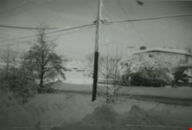
Snowy neighbourhood
https://search.heritageburnaby.ca/link/archivedescription38005
- Repository
- City of Burnaby Archives
- Date
- January 1972 (date of original), copied 1991
- Collection/Fonds
- Burnaby Historical Society fonds
- Description Level
- Item
- Physical Description
- 1 photograph : b&w ; 3.2 x 4.7 cm print on contact sheet 20.5 x 26.4 cm
- Scope and Content
- Photograph of a snowy neighbourhood at sunrise. MacPherson Junior High School is visible in the background.
- Repository
- City of Burnaby Archives
- Date
- January 1972 (date of original), copied 1991
- Collection/Fonds
- Burnaby Historical Society fonds
- Subseries
- Burnaby Image Bank subseries
- Physical Description
- 1 photograph : b&w ; 3.2 x 4.7 cm print on contact sheet 20.5 x 26.4 cm
- Description Level
- Item
- Record No.
- 370-592
- Access Restriction
- No restrictions
- Reproduction Restriction
- No restrictions
- Accession Number
- BHS1999-03
- Scope and Content
- Photograph of a snowy neighbourhood at sunrise. MacPherson Junior High School is visible in the background.
- Media Type
- Photograph
- Notes
- Title based on contents of photograph
- 1 b&w copy negative accompanying
- Copied from col. photograph
- Annotation at bottom of photograph reads, "Jan. Sunrise 1972"
- Geographic Access
- Rumble Street
- MacPherson Avenue
- Historic Neighbourhood
- Alta-Vista (Historic Neighbourhood)
- Planning Study Area
- Clinton-Glenwood Area
Images

![South Burnaby neighbours, [2002] thumbnail](/media/hpo/_Data/_Archives_Images/_Unrestricted/535/535-2605-2.jpg?width=280)
South Burnaby neighbours
https://search.heritageburnaby.ca/link/archivedescription97077
- Repository
- City of Burnaby Archives
- Date
- [2002]
- Collection/Fonds
- Burnaby NewsLeader photograph collection
- Description Level
- File
- Physical Description
- 3 photographs (tiff) : col.
- Scope and Content
- File contains photographs of Bill and Julia Giuriato and Sam and Angelina Ciotti in their south Burnaby neighbourhood, near the South Slope area. Photographs depict Bill and Julia Guiriato leaning against a pole outside of the L'Arche Greater Vancouver at 7401 Sussex Avenue; Sam and Angelina Ciotti…
- Repository
- City of Burnaby Archives
- Date
- [2002]
- Collection/Fonds
- Burnaby NewsLeader photograph collection
- Physical Description
- 3 photographs (tiff) : col.
- Description Level
- File
- Record No.
- 535-2605
- Access Restriction
- No restrictions
- Reproduction Restriction
- No restrictions
- Accession Number
- 2018-12
- Scope and Content
- File contains photographs of Bill and Julia Giuriato and Sam and Angelina Ciotti in their south Burnaby neighbourhood, near the South Slope area. Photographs depict Bill and Julia Guiriato leaning against a pole outside of the L'Arche Greater Vancouver at 7401 Sussex Avenue; Sam and Angelina Ciotti working in the garden of their home; and the two couples leaning over the back fence between their homes.
- Subjects
- Geographic Features - Neighbourhoods
- Media Type
- Photograph
- Photographer
- Ray, Steve
- Notes
- Title based on caption
- Collected by editorial for use in a July 2002 issue of the Burnaby NewsLeader
- Caption from metadata for 535-2605-1: "Bill and Julia Giuriato in their south Burnaby neighbourhood."
- Caption from metadata for 535-2605-2: "Sam and Angelina Ciotti and Bill and Julia Giuriato over their back fence in their south Burnaby neighbourhood."
- Caption from metadata for 535-2605-3: "Sam and Angelina Ciotti, pick from their huge garden in their back yard. The Ciotti's share their harvest with their neighbours."
- Geographic Access
- Sussex Avenue
- Historic Neighbourhood
- Alta Vista (Historic Neighbourhood)
- Planning Study Area
- Sussex-Nelson Area
Images
![South Burnaby neighbours, [2002] thumbnail](/media/hpo/_Data/_Archives_Images/_Unrestricted/535/535-2605-2.jpg)
![Traffic in Lakeview-Edmonds, [2001] thumbnail](/media/hpo/_Data/_Archives_Images/_Unrestricted/535/535-2959-1.jpg?width=280)
Traffic in Lakeview-Edmonds
https://search.heritageburnaby.ca/link/archivedescription97676
- Repository
- City of Burnaby Archives
- Date
- [2001]
- Collection/Fonds
- Burnaby NewsLeader photograph collection
- Description Level
- File
- Physical Description
- 4 photographs (tiff) : col.
- Scope and Content
- File contains photographs related to transportation and traffic in the Edmonds area of Burnaby. Photographs depict Argus Carriers delivery driver Terry Doyle at work in his delivery truck, and Lidia Rossi, Porcellato, and Muriel Logan, all members of the Lakeview-Edmonds Neighbourhood Association, …
- Repository
- City of Burnaby Archives
- Date
- [2001]
- Collection/Fonds
- Burnaby NewsLeader photograph collection
- Physical Description
- 4 photographs (tiff) : col.
- Description Level
- File
- Record No.
- 535-2959
- Access Restriction
- No restrictions
- Reproduction Restriction
- No restrictions
- Accession Number
- 2018-12
- Scope and Content
- File contains photographs related to transportation and traffic in the Edmonds area of Burnaby. Photographs depict Argus Carriers delivery driver Terry Doyle at work in his delivery truck, and Lidia Rossi, Porcellato, and Muriel Logan, all members of the Lakeview-Edmonds Neighbourhood Association, posing on a road and interacting with traffic at the corner of 6th and Edmonds.
- Media Type
- Photograph
- Photographer
- Bartel, Mario
- Notes
- Title based on caption
- Collected by editorial for use in a November 2001 issue of the Burnaby NewsLeader
- Caption from metadata for 535-2959-1: "Terry Doyle, a delivery driver for Argus Carriers, heads out to the busy streets of the Lower Mainland to deliver packages."
- Caption from metadata for 535-2959-2: "Terry Doyle, a delivery driver for Argus Carriers, says he tries not to bring the stresses of driving around the Lower Mainland home with him."
- Caption from metadata for 535-2959-3: "Lidia Rossi, Sophia Porcellato, and Muriel Logan have formed the Lakeview-Edmonds Neighbourhood Association to discuss ways to keep rat-running traffic out of their neighbourhood."
- Caption from metadata for 535-2959-4: "Lidia Rossi, of the Lakeview-Edmonds Neighborhood Association, motions to a rat-running motorist, at the corner of 6th St. and Edmonds, to stay out of the residential streets."
- Geographic Access
- 6th Street
- Edmonds Street
- Historic Neighbourhood
- Edmonds (Historic Neighbourhood)
- Planning Study Area
- Lakeview-Mayfield Area
Images
![Traffic in Lakeview-Edmonds, [2001] thumbnail](/media/hpo/_Data/_Archives_Images/_Unrestricted/535/535-2959-1.jpg)
![Trimming hedges in the Metrotown area, [1999] thumbnail](/media/hpo/_Data/_Archives_Images/_Unrestricted/535/535-3390.jpg?width=280)
Trimming hedges in the Metrotown area
https://search.heritageburnaby.ca/link/archivedescription98380
- Repository
- City of Burnaby Archives
- Date
- [1999]
- Collection/Fonds
- Burnaby NewsLeader photograph collection
- Description Level
- Item
- Physical Description
- 1 photograph (tiff) : col.
- Scope and Content
- Photograph of two unidentified people trimming hedges in the Metrotown area. The SkyTrain tracks, Metropolis at Metrotown mall, and towers are visible behind them.
- Repository
- City of Burnaby Archives
- Date
- [1999]
- Collection/Fonds
- Burnaby NewsLeader photograph collection
- Physical Description
- 1 photograph (tiff) : col.
- Description Level
- Item
- Record No.
- 535-3390
- Access Restriction
- No restrictions
- Reproduction Restriction
- No restrictions
- Accession Number
- 2018-12
- Scope and Content
- Photograph of two unidentified people trimming hedges in the Metrotown area. The SkyTrain tracks, Metropolis at Metrotown mall, and towers are visible behind them.
- Names
- Metrotown
- Media Type
- Photograph
- Notes
- Title based on contents of photograph
- Collected by editorial for use in an October 1999 issue of the Burnaby NewsLeader
- Historic Neighbourhood
- Central Park (Historic Neighbourhood)
- Planning Study Area
- Maywood Area
Images
![Trimming hedges in the Metrotown area, [1999] thumbnail](/media/hpo/_Data/_Archives_Images/_Unrestricted/535/535-3390.jpg)

Vancouver Heights
https://search.heritageburnaby.ca/link/archivedescription35426
- Repository
- City of Burnaby Archives
- Date
- 1913 (date of original), copied 1986
- Collection/Fonds
- Burnaby Historical Society fonds
- Description Level
- Item
- Physical Description
- 1 photograph : b&w ; 12.7 x 17.8 cm print
- Scope and Content
- Photograph of a general view of Vancouver Heights. The car is on Ingleton Avenue near the corner of Triumph Street, looking east to MacDonald Avenue and Gilmore Avenue. Vancouver Heights Presbyterian Church and Gilmore Avenue School can be seen in the background at the right. The photograph is by D…
- Repository
- City of Burnaby Archives
- Date
- 1913 (date of original), copied 1986
- Collection/Fonds
- Burnaby Historical Society fonds
- Subseries
- Pioneer Tales subseries
- Physical Description
- 1 photograph : b&w ; 12.7 x 17.8 cm print
- Description Level
- Item
- Record No.
- 204-284
- Access Restriction
- No restrictions
- Reproduction Restriction
- No restrictions
- Accession Number
- BHS1988-03
- Scope and Content
- Photograph of a general view of Vancouver Heights. The car is on Ingleton Avenue near the corner of Triumph Street, looking east to MacDonald Avenue and Gilmore Avenue. Vancouver Heights Presbyterian Church and Gilmore Avenue School can be seen in the background at the right. The photograph is by Dr. Carl Eaton, teacher, principal and later family physician.
- Media Type
- Photograph
- Photographer
- Eaton, Dr. Carl
- Notes
- Title based on contents of photograph
- Geographic Access
- Ingleton Avenue
- MacDonald Avenue
- Triumph Street
- Historic Neighbourhood
- Vancouver Heights (Historic Neighbourhood)
- Planning Study Area
- Willingdon Heights Area
Images

![Vancouver Heights, [1920] thumbnail](/media/hpo/_Data/_Archives_Images/_Unrestricted/371/381-001.jpg?width=280)
Vancouver Heights
https://search.heritageburnaby.ca/link/archivedescription38274
- Repository
- City of Burnaby Archives
- Date
- [1920]
- Collection/Fonds
- Burnaby Historical Society fonds
- Description Level
- Item
- Physical Description
- 1 photograph : sepia ; 12.5 x 18 cm
- Scope and Content
- Photograph of three houses in the Vancouver Heights area, North Burnaby. The exact location of this photograph is unknown.
- Repository
- City of Burnaby Archives
- Date
- [1920]
- Collection/Fonds
- Burnaby Historical Society fonds
- Subseries
- Photographs subseries
- Physical Description
- 1 photograph : sepia ; 12.5 x 18 cm
- Description Level
- Item
- Record No.
- 381-001
- Access Restriction
- No restrictions
- Reproduction Restriction
- No known restrictions
- Accession Number
- BHS2007-04
- Scope and Content
- Photograph of three houses in the Vancouver Heights area, North Burnaby. The exact location of this photograph is unknown.
- Subjects
- Geographic Features - Neighbourhoods
- Media Type
- Photograph
- Notes
- Title based on contents of photograph.
- Historic Neighbourhood
- Vancouver Heights (Historic Neighbourhood)
- Planning Study Area
- Burnaby Heights Area
Images
![Vancouver Heights, [1920] thumbnail](/media/hpo/_Data/_Archives_Images/_Unrestricted/371/381-001.jpg)

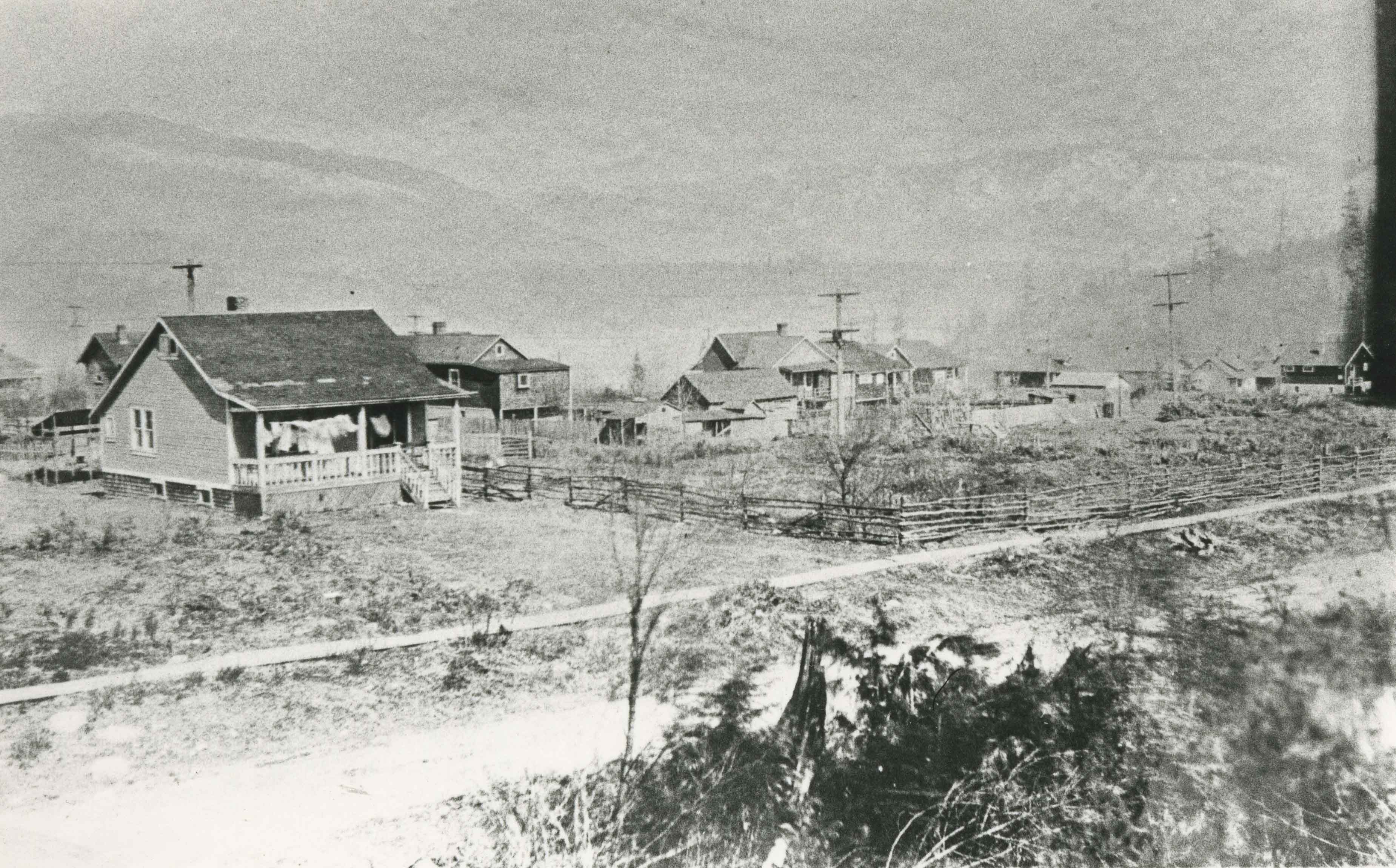
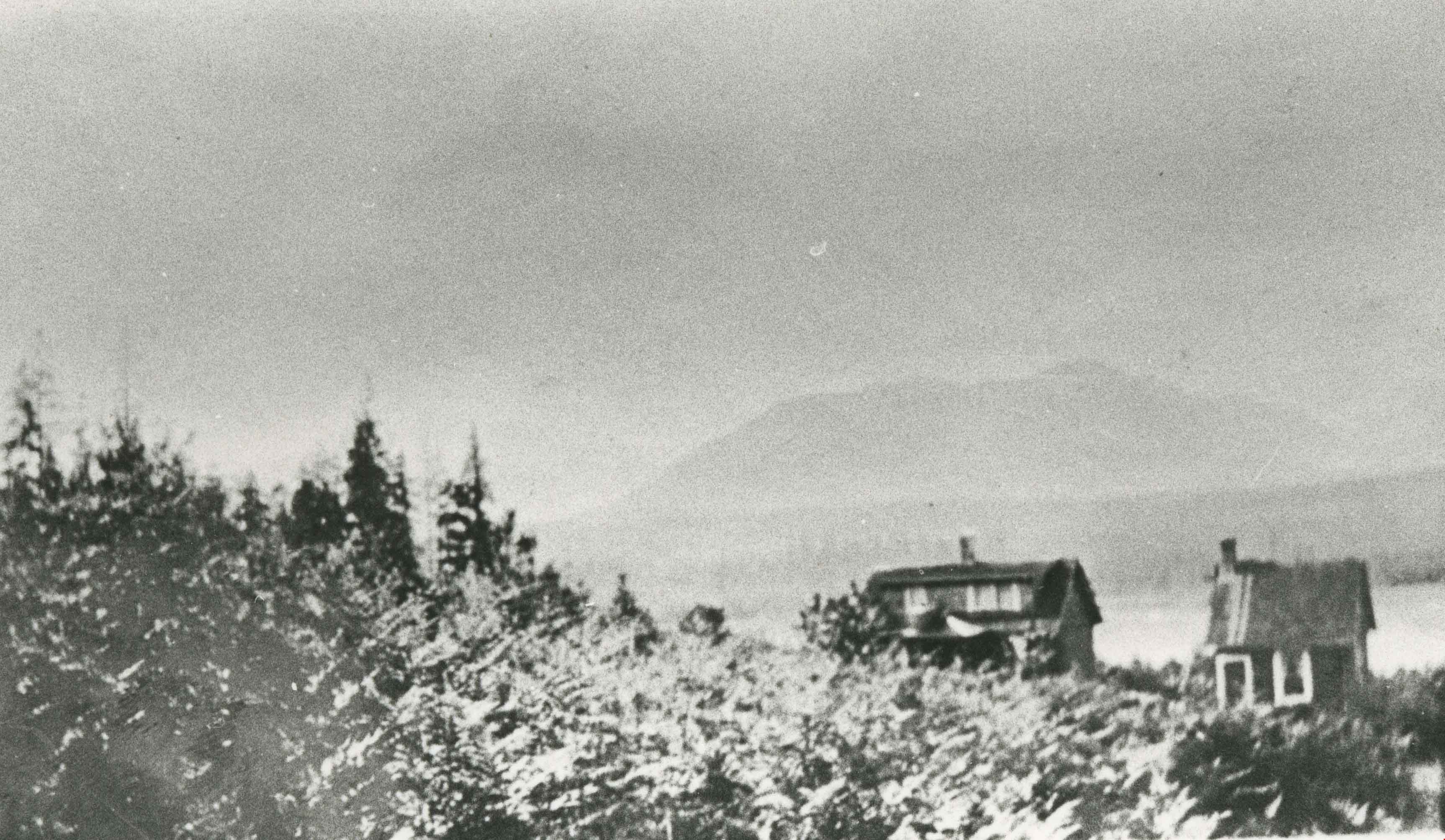
Vancouver Heights area
https://search.heritageburnaby.ca/link/archivedescription35266
- Repository
- City of Burnaby Archives
- Date
- 1911 (date of original), copied 1986
- Collection/Fonds
- Burnaby Historical Society fonds
- Description Level
- Item
- Physical Description
- 1 photograph : b&w ; 12.7 x 17.8 cm print
- Scope and Content
- Photograph of Carleton Avenue and Yale Street area in the neighbourhood where David Taylor and Henry Ward built their duplex for their families in 1911, when they emigrated from England. Both families had two children: Douglas and Hilda Ward, and Marjorie and Winnie Taylor.
- Repository
- City of Burnaby Archives
- Date
- 1911 (date of original), copied 1986
- Collection/Fonds
- Burnaby Historical Society fonds
- Subseries
- Pioneer Tales subseries
- Physical Description
- 1 photograph : b&w ; 12.7 x 17.8 cm print
- Description Level
- Item
- Record No.
- 204-123
- Access Restriction
- No restrictions
- Reproduction Restriction
- No known restrictions
- Accession Number
- BHS1988-03
- Scope and Content
- Photograph of Carleton Avenue and Yale Street area in the neighbourhood where David Taylor and Henry Ward built their duplex for their families in 1911, when they emigrated from England. Both families had two children: Douglas and Hilda Ward, and Marjorie and Winnie Taylor.
- Subjects
- Geographic Features - Neighbourhoods
- Media Type
- Photograph
- Notes
- Title based on contents of photograph
- Geographic Access
- Carleton Avenue
- Yale Street
- Historic Neighbourhood
- Vancouver Heights (Historic Neighbourhood)
- Planning Study Area
- Burnaby Heights Area
Images

Vancouver Heights area
https://search.heritageburnaby.ca/link/archivedescription35267
- Repository
- City of Burnaby Archives
- Date
- 1911 (date of original), copied 1986
- Collection/Fonds
- Burnaby Historical Society fonds
- Description Level
- Item
- Physical Description
- 1 photograph : b&w ; 12.7 x 17.8 cm print
- Scope and Content
- Photograph taken from the corner of Carleton Avenue and McGill Street, looking northeast. This later became the site of McGill Park.
- Repository
- City of Burnaby Archives
- Date
- 1911 (date of original), copied 1986
- Collection/Fonds
- Burnaby Historical Society fonds
- Subseries
- Pioneer Tales subseries
- Physical Description
- 1 photograph : b&w ; 12.7 x 17.8 cm print
- Description Level
- Item
- Record No.
- 204-124
- Access Restriction
- No restrictions
- Reproduction Restriction
- No known restrictions
- Accession Number
- BHS1988-03
- Scope and Content
- Photograph taken from the corner of Carleton Avenue and McGill Street, looking northeast. This later became the site of McGill Park.
- Subjects
- Geographic Features - Neighbourhoods
- Media Type
- Photograph
- Photographer
- Sutcliffe, Arthur
- Notes
- Title based on contents of photograph
- Geographic Access
- Carleton Avenue North
- McGill Park
- McGill Street
- Historic Neighbourhood
- Vancouver Heights (Historic Neighbourhood)
- Planning Study Area
- Burnaby Heights Area
Images