More like 'Interview with Mayor Derek Corrigan by Kathy Bossort January 28, 2016 - Track 6'
Narrow Results By
Subject
- Aerial Photographs 4
- Agricultural Tools and Equipment 1
- Agricultural Tools and Equipment - Plows 1
- Agriculture - Fruit and Berries 1
- Animals - Birds 2
- Animals - Dogs 6
- Animals - Fowl 1
- Animals - Oxen 1
- Buildings - Commercial - Bus Stations 1
- Buildings - Commercial - Hotels and Motels 1
- Buildings - Industrial - Mills 1
- Buildings - Recreational - Outdoor Swimming Pools 1

Alfred Bingham's writings - Track 1
https://search.heritageburnaby.ca/link/oralhistory251
- Repository
- City of Burnaby Archives
- Date Range
- 1865-1919
- Length
- 0:10:18
- Summary
- This portion of the recording includes Alfred Bingham's essay entitled Stump Rangers, a listing of early settlers that includes addresses and short descriptions, essays on Confederation Park, land clearing and on Burnaby's first Council meeting.
- Repository
- City of Burnaby Archives
- Summary
- This portion of the recording includes Alfred Bingham's essay entitled Stump Rangers, a listing of early settlers that includes addresses and short descriptions, essays on Confederation Park, land clearing and on Burnaby's first Council meeting.
- Date Range
- 1865-1919
- Photo Info
- Alfred Bingham, April 20, 1947. Item no. 010-066
- Length
- 0:10:18
- Scope and Content
- Recording is of Alfred Bingham's writings, as read by Alfred Bingham. Major themes discussed are: Pioneers, early days in Burnaby and the Co-op Movement. To view "Narrow By" terms for each track expand this description and see "Notes".
- Biographical Notes
- Alfred "Alf" Bingham was born in England in 1892 and moved to Canada in 1912. His first job in Canada was laying track for the Grand Trunk Pacific Railway (GTPR) from Edmonton to McBride in 1912. His second was in Vancouver at the Rat Portage Mill on False Creek, working on the Resaw machine. He quit after one week due to poor working conditions. After taking part in the 1919 Winnipeg General Strike as a delegate of the Retail and Mailorder Union (A.F.L.) on the Winnipeg Trades and Labour Council, Alfred moved to Burnaby where he and fellow Burnaby residents Aungus McLean and Percy Little worked ten hour days to build a Shingle Mill on the edge of Burnaby Lake for Simpson & Giberson. George Green, carpenter and millwright (author of “The History of Burnaby”) also helped in the construction of the mill. Alfred built his own home from lumber cut from the mill in the Lochdale area on Sherlock Street between Curtis Street and Kitchener Street. On April 10, 1920 Alfred married Mary Jane “Ada” Reynolds. Alfred and Ada often took in foster children during their marriage. Due to her nursing experience, Ada was often called upon to deliver babies in the Burnaby area. Alfred and Ada Bingham were instrumental members of the Army of the Common Good, collecting vegetables and grains from growers in the area and even producing over 125 tons of vegetables from its own gardens to feed children and youth suffering from the lack of resources during the Depression years. The army was in operation for ten years and during that time the members organised the Credit Union movement of British Columbia and drew up the Credit Union act thorough the Vancouver Co-operative Council. They also started Co-Op stores and the Co-Op Wholesale Society. Alfred was also Secretary of the Burnaby Housing committee and in 1946 he became the Secretary of the North Burnaby Labour Progressive Party (LPP). Mary Jane “Ada” (Reynolds) Bingham died on August 9, 1969. Her husband Alfred died on April 29, 1979.
- Total Tracks
- 12
- Total Length
- 1:38:06
- Interviewee Name
- Bingham, Alfred "Alf"
- Collection/Fonds
- Burnaby Historical Society fonds
- Subseries
- Oral history subseries
- Transcript Available
- MSS142-001 contains transcripts for each of the short stories
- Media Type
- Sound Recording
- Web Notes
- Interview was digitized in 2010 allowing it to be accessible on Heritage Burnaby. The digitization project was initiated by the Community Heritage Commission with support from City of Burnaby Council and the BC History Digitization Program of the Irving K. Barber Learning Centre, University of British Columbia. It was recognized by the Heritage Society of BC with an award in 2012.
Images

Audio Tracks
Track one of recording of Alfred Bingham's writings
Track one of recording of Alfred Bingham's writings
https://search.heritageburnaby.ca/media/hpo/_Data/_Archives_Oral_Histories/_Unrestricted/100-13-20-2/100-13-20-2_Track_1.mp3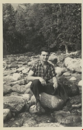
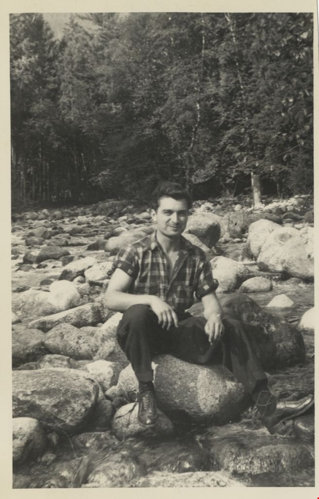
John Yanko at Kokanee Park
https://search.heritageburnaby.ca/link/archivedescription77915
- Repository
- City of Burnaby Archives
- Date
- 1948
- Collection/Fonds
- Yanko family fonds
- Description Level
- Item
- Physical Description
- 1 photograph : b&w ; 11.5 x 7 cm
- Scope and Content
- Photograph of John Ivan Yanko sitting on a rock along the river at Kokanee Park (now Kokanee Glacier Provincial Park).
- Repository
- City of Burnaby Archives
- Date
- 1948
- Collection/Fonds
- Yanko family fonds
- Physical Description
- 1 photograph : b&w ; 11.5 x 7 cm
- Material Details
- Secured to album page with photo corners
- Description Level
- Item
- Record No.
- 545-097
- Access Restriction
- No restrictions
- Reproduction Restriction
- No known restrictions
- Accession Number
- 2012-09
- Scope and Content
- Photograph of John Ivan Yanko sitting on a rock along the river at Kokanee Park (now Kokanee Glacier Provincial Park).
- Names
- Yanko, John Ivan
- Media Type
- Photograph
- Notes
- Title based on contents of photograph
- Note written on album page reads: "Kokanee Park / Johnny 1948"
- Note in blue ink on verso of photograph reads: "1948"
Images
![Lois Hollands-Coutts and Charles Hollands, [1945] (date of original), copied 1991 thumbnail](/media/hpo/_Data/_Archives_Images/_Unrestricted/370/370-429.jpg?width=280)
Lois Hollands-Coutts and Charles Hollands
https://search.heritageburnaby.ca/link/archivedescription37841
- Repository
- City of Burnaby Archives
- Date
- [1945] (date of original), copied 1991
- Collection/Fonds
- Burnaby Historical Society fonds
- Description Level
- Item
- Physical Description
- 1 photograph : b&w ; 4.1 x 2.8 cm print on contact sheet 20.6 x 26.7 cm
- Scope and Content
- Photograph of Lois Holland-Coutts and her father, Charles Hollands, on a path leading to Robert Burnaby Park, near 6th Street at 19th Avenue.
- Repository
- City of Burnaby Archives
- Date
- [1945] (date of original), copied 1991
- Collection/Fonds
- Burnaby Historical Society fonds
- Subseries
- Burnaby Image Bank subseries
- Physical Description
- 1 photograph : b&w ; 4.1 x 2.8 cm print on contact sheet 20.6 x 26.7 cm
- Description Level
- Item
- Record No.
- 370-429
- Access Restriction
- No restrictions
- Reproduction Restriction
- No known restrictions
- Accession Number
- BHS1999-03
- Scope and Content
- Photograph of Lois Holland-Coutts and her father, Charles Hollands, on a path leading to Robert Burnaby Park, near 6th Street at 19th Avenue.
- Media Type
- Photograph
- Notes
- Title based on contents of photograph
- 1 b&w copy negative accompanying
- Negative has a pink cast
- Geographic Access
- 6th Street
- 19th Avenue
- Historic Neighbourhood
- East Burnaby (Historic Neighbourhood)
- Planning Study Area
- Second Street Area
Images
![Lois Hollands-Coutts and Charles Hollands, [1945] (date of original), copied 1991 thumbnail](/media/hpo/_Data/_Archives_Images/_Unrestricted/370/370-429.jpg)
![Lower Mainland, [1946] thumbnail](/media/hpo/_Data/_Archives_Images/_Unrestricted/485/486-039.jpg?width=280)
Lower Mainland
https://search.heritageburnaby.ca/link/archivedescription55645
- Repository
- City of Burnaby Archives
- Date
- [1946]
- Collection/Fonds
- Charles MacSorley fonds
- Description Level
- Item
- Physical Description
- 1 photograph : b&w ; 20.5 x 25.5 cm
- Scope and Content
- Aerial photograph of the Lower Mainland of British Columbia, looking east over Stanley Park and the Burrard Inlet. A printed description accompanying the photograph reads: "A view of the Lower Mainland taken along Burrard Inlet. The block of land in the lower centre of the photograph is Stanley Par…
- Repository
- City of Burnaby Archives
- Date
- [1946]
- Collection/Fonds
- Charles MacSorley fonds
- Physical Description
- 1 photograph : b&w ; 20.5 x 25.5 cm
- Description Level
- Item
- Record No.
- 486-039
- Access Restriction
- No restrictions
- Reproduction Restriction
- No known restrictions
- Accession Number
- 2005-14
- Scope and Content
- Aerial photograph of the Lower Mainland of British Columbia, looking east over Stanley Park and the Burrard Inlet. A printed description accompanying the photograph reads: "A view of the Lower Mainland taken along Burrard Inlet. The block of land in the lower centre of the photograph is Stanley Park with the business section of the City of Vancouver connected thereto. To the left of the Inlet is the City and District of North Vancouver and just above Vancouver is the District of Burnaby. The mountains at the extreme top of the photograph are the Coastal Range and are over a hundred miles away. The mountains to the left can be reached by a fifteen-minute drive from the city. Presented with the compliments of the Corporation of the District of Burnaby."
- Media Type
- Photograph
- Notes
- Title based on caption
- Caption on recto reads: "Lower Mainland"
- Printed description adhered to verso of photograph
Images
![Lower Mainland, [1946] thumbnail](/media/hpo/_Data/_Archives_Images/_Unrestricted/485/486-039.jpg)
![Clearing Deer Lake frontage, [1891] thumbnail](/media/hpo/_Data/_Archives_Images/_Unrestricted/477/477-842.jpg?width=280)
Clearing Deer Lake frontage
https://search.heritageburnaby.ca/link/archivedescription39523
- Repository
- City of Burnaby Archives
- Date
- [1891]
- Collection/Fonds
- Peers Family and Hill Family fonds
- Description Level
- Item
- Physical Description
- 1 photograph : b&w ; 9.5 x 14.3 cm on page 21.5 x 8 cm (pasted in album)
- Scope and Content
- Photograph of a man and his dog sitting on a large felled tree along the shore of Deer Lake. The man is most likely Claude Hill, and early resident of the Deer Lake area.
- Repository
- City of Burnaby Archives
- Date
- [1891]
- Collection/Fonds
- Peers Family and Hill Family fonds
- Physical Description
- 1 photograph : b&w ; 9.5 x 14.3 cm on page 21.5 x 8 cm (pasted in album)
- Description Level
- Item
- Record No.
- 477-842
- Access Restriction
- No restrictions
- Reproduction Restriction
- No known restrictions
- Accession Number
- 2007-12
- Scope and Content
- Photograph of a man and his dog sitting on a large felled tree along the shore of Deer Lake. The man is most likely Claude Hill, and early resident of the Deer Lake area.
- Media Type
- Photograph
- Notes
- Title based on caption accompanying photograph
- Geographic Access
- Deer Lake
- Historic Neighbourhood
- Burnaby Lake (Historic Neighbourhood)
Images
![Clearing Deer Lake frontage, [1891] thumbnail](/media/hpo/_Data/_Archives_Images/_Unrestricted/477/477-842.jpg)
![Douglas Road, [1897] (date of original), copied 1978 thumbnail](/media/hpo/_Data/_BVM_Images/1978/1978_0001_0001_001.jpg?width=280)
Douglas Road
https://search.heritageburnaby.ca/link/museumdescription447
- Repository
- Burnaby Village Museum
- Date
- [1897] (date of original), copied 1978
- Collection/Fonds
- Burnaby Village Museum Photograph collection
- Description Level
- Item
- Physical Description
- 1 photograph : b&w ; 20.2 x 25.2 cm print
- Scope and Content
- Photograph of Douglas Road (later renamed in part Canada Way), near Stanley Street. To the right is the Sprott family property, where a few wooden buildings are visible in the cleared area. Charles Sprott, head of the Sprott family, was an important Burnaby politician who was continuously elected t…
- Repository
- Burnaby Village Museum
- Collection/Fonds
- Burnaby Village Museum Photograph collection
- Description Level
- Item
- Physical Description
- 1 photograph : b&w ; 20.2 x 25.2 cm print
- Scope and Content
- Photograph of Douglas Road (later renamed in part Canada Way), near Stanley Street. To the right is the Sprott family property, where a few wooden buildings are visible in the cleared area. Charles Sprott, head of the Sprott family, was an important Burnaby politician who was continuously elected to serve in the municiality as councillor from 1895 to 1903 and as Reeve from 1904 to 1905.
- Subjects
- Geographic Features - Roads
- Land Clearing
- Geographic Access
- Douglas Road
- Canada Way
- Stanley Street
- Accession Code
- HV978.1.1
- Access Restriction
- No restrictions
- Reproduction Restriction
- No known restrictions
- Date
- [1897] (date of original), copied 1978
- Media Type
- Photograph
- Historic Neighbourhood
- Burnaby Lake (Historic Neighbourhood)
- Planning Study Area
- Lakeview-Mayfield Area
- Scan Resolution
- 600
- Scan Date
- 2023-07-25
- Notes
- Title based on contents of photograph
Images
![Douglas Road, [1897] (date of original), copied 1978 thumbnail](/media/hpo/_Data/_BVM_Images/1978/1978_0001_0001_001.jpg)

Gilmore Avenue and Douglas Road
https://search.heritageburnaby.ca/link/archivedescription34164
- Repository
- City of Burnaby Archives
- Date
- May 1, 1947
- Collection/Fonds
- Burnaby Historical Society fonds
- Description Level
- Item
- Physical Description
- 1 photograph : b&w negative ; 6.8 x 11.8 cm
- Scope and Content
- Photograph of cleared land at Gilmore Avenue and Douglas Road. Houses under construction can be seen in the background. This is part of the Willingdon Heights subdivision site.
- Repository
- City of Burnaby Archives
- Date
- May 1, 1947
- Collection/Fonds
- Burnaby Historical Society fonds
- Subseries
- Alfred Bingham subseries
- Physical Description
- 1 photograph : b&w negative ; 6.8 x 11.8 cm
- Description Level
- Item
- Record No.
- 010-081
- Access Restriction
- No restrictions
- Reproduction Restriction
- No known restrictions
- Accession Number
- BHS2007-04
- Scope and Content
- Photograph of cleared land at Gilmore Avenue and Douglas Road. Houses under construction can be seen in the background. This is part of the Willingdon Heights subdivision site.
- Subjects
- Industries - Construction
- Buildings - Residential - Houses
- Land Clearing
- Geographic Features - Roads
- Media Type
- Photograph
- Photographer
- Bingham, Alfred "Alf"
- Notes
- Title based on contents of photograph
- Geographic Access
- Gilmore Avenue
- Douglas Road
Images


Graveley Street and Willingdon Avenue
https://search.heritageburnaby.ca/link/archivedescription34201
- Repository
- City of Burnaby Archives
- Date
- June 17, 1947
- Collection/Fonds
- Burnaby Historical Society fonds
- Description Level
- Item
- Physical Description
- 1 photograph : b&w negative ; 6.8 x 11.6 cm
- Scope and Content
- Photograph of Graveley Street at Willingdon Avenue; the road is in the foreground with brush and cleared land visible beside the road. This is part of the Willingdon Heights subdivision site.
- Repository
- City of Burnaby Archives
- Date
- June 17, 1947
- Collection/Fonds
- Burnaby Historical Society fonds
- Subseries
- Alfred Bingham subseries
- Physical Description
- 1 photograph : b&w negative ; 6.8 x 11.6 cm
- Description Level
- Item
- Record No.
- 010-117
- Access Restriction
- No restrictions
- Reproduction Restriction
- No known restrictions
- Accession Number
- BHS2007-04
- Scope and Content
- Photograph of Graveley Street at Willingdon Avenue; the road is in the foreground with brush and cleared land visible beside the road. This is part of the Willingdon Heights subdivision site.
- Subjects
- Land Clearing
- Geographic Features - Roads
- Media Type
- Photograph
- Photographer
- Bingham, Alfred "Alf"
- Notes
- Title based on contents of photograph
- Geographic Access
- Graveley Street
- Willingdon Avenue
Images


Kitchener Street and William Avenue
https://search.heritageburnaby.ca/link/archivedescription34237
- Repository
- City of Burnaby Archives
- Date
- August 12, 1947
- Collection/Fonds
- Burnaby Historical Society fonds
- Description Level
- Item
- Physical Description
- 1 photograph : b&w negative ; 6.8 x 12.5 cm
- Scope and Content
- Photograph of brush and cleared land at Kitchener Street and William Street with houses visible in background. This is part of the Willingdon Heights subdivision site.
- Repository
- City of Burnaby Archives
- Date
- August 12, 1947
- Collection/Fonds
- Burnaby Historical Society fonds
- Subseries
- Alfred Bingham subseries
- Physical Description
- 1 photograph : b&w negative ; 6.8 x 12.5 cm
- Description Level
- Item
- Record No.
- 010-149
- Access Restriction
- No restrictions
- Reproduction Restriction
- No known restrictions
- Accession Number
- BHS2007-04
- Scope and Content
- Photograph of brush and cleared land at Kitchener Street and William Street with houses visible in background. This is part of the Willingdon Heights subdivision site.
- Subjects
- Land Clearing
- Geographic Features - Roads
- Media Type
- Photograph
- Photographer
- Bingham, Alfred "Alf"
- Notes
- Title based on contents of photograph
- Geographic Access
- Kitchener Street
- William Street
Images


Madison Avenue
https://search.heritageburnaby.ca/link/archivedescription34243
- Repository
- City of Burnaby Archives
- Date
- August 20, 1947
- Collection/Fonds
- Burnaby Historical Society fonds
- Description Level
- Item
- Physical Description
- 1 photograph : b&w negative ; 6.8 x 11.4 cm
- Scope and Content
- Photograph of Madison Avenue (east) with the road and cleared land in the foreground, and houses in the background. This is part of the Willingdon Heights subdivision site.
- Repository
- City of Burnaby Archives
- Date
- August 20, 1947
- Collection/Fonds
- Burnaby Historical Society fonds
- Subseries
- Alfred Bingham subseries
- Physical Description
- 1 photograph : b&w negative ; 6.8 x 11.4 cm
- Description Level
- Item
- Record No.
- 010-155
- Access Restriction
- No restrictions
- Reproduction Restriction
- No known restrictions
- Accession Number
- BHS2007-04
- Scope and Content
- Photograph of Madison Avenue (east) with the road and cleared land in the foreground, and houses in the background. This is part of the Willingdon Heights subdivision site.
- Media Type
- Photograph
- Photographer
- Bingham, Alfred "Alf"
- Notes
- Title based on contents of photograph
- Geographic Access
- Madison Avenue
Images


Madison Avenue
https://search.heritageburnaby.ca/link/archivedescription34244
- Repository
- City of Burnaby Archives
- Date
- August 20, 1947
- Collection/Fonds
- Burnaby Historical Society fonds
- Description Level
- Item
- Physical Description
- 1 photograph : b&w negative ; 6.8 x 11.4 cm
- Scope and Content
- Photograph of Madison Avenue (southeast) with the road and cleared land in the foreground, and houses in the background. This is part of the Willingdon Heights subdivision site.
- Repository
- City of Burnaby Archives
- Date
- August 20, 1947
- Collection/Fonds
- Burnaby Historical Society fonds
- Subseries
- Alfred Bingham subseries
- Physical Description
- 1 photograph : b&w negative ; 6.8 x 11.4 cm
- Description Level
- Item
- Record No.
- 010-156
- Access Restriction
- No restrictions
- Reproduction Restriction
- No known restrictions
- Accession Number
- BHS2007-04
- Scope and Content
- Photograph of Madison Avenue (southeast) with the road and cleared land in the foreground, and houses in the background. This is part of the Willingdon Heights subdivision site.
- Media Type
- Photograph
- Photographer
- Bingham, Alfred "Alf"
- Notes
- Title based on contents of photograph
- Geographic Access
- Madison Avenue
Images

![Paved road, [1948] thumbnail](/media/hpo/_Data/_BVM_Images/1971/1971_0012_0087_001.jpg?width=280)
Paved road
https://search.heritageburnaby.ca/link/museumdescription19
- Repository
- Burnaby Village Museum
- Date
- [1948]
- Collection/Fonds
- Burnaby Village Museum Photograph collection
- Description Level
- Item
- Physical Description
- 1 photograph : sepia ; 6.8 x 11.4 cm
- Scope and Content
- Photograph of a paved road running through a cleared lot. There is an electric post on the roadside, and woods in the background. Catalogue information from 1976 indicates that it is a street development in Burnaby, ca. 1948. This may be the site of the Willingdon Heights subdivision. Annotation o…
- Repository
- Burnaby Village Museum
- Collection/Fonds
- Burnaby Village Museum Photograph collection
- Description Level
- Item
- Physical Description
- 1 photograph : sepia ; 6.8 x 11.4 cm
- Scope and Content
- Photograph of a paved road running through a cleared lot. There is an electric post on the roadside, and woods in the background. Catalogue information from 1976 indicates that it is a street development in Burnaby, ca. 1948. This may be the site of the Willingdon Heights subdivision. Annotation on lower right front of photograph: "26." Stamped on back of photograph: "321X."
- Subjects
- Geographic Features - Roads
- Land Clearing
- Names
- Bingham, Alfred "Alf"
- Accession Code
- HV971.12.87
- Access Restriction
- No restrictions
- Reproduction Restriction
- No known restrictions
- Date
- [1948]
- Media Type
- Photograph
- Historic Neighbourhood
- Vancouver Heights (Historic Neighbourhood)
- Planning Study Area
- Willingdon Heights Area
- Scan Resolution
- 600
- Scan Date
- 2023-03-21
- Notes
- Title based on contents of photograph
Images
![Paved road, [1948] thumbnail](/media/hpo/_Data/_BVM_Images/1971/1971_0012_0087_001.jpg)

William Street and Carleton Avenue
https://search.heritageburnaby.ca/link/archivedescription34248
- Repository
- City of Burnaby Archives
- Date
- August 30, 1947
- Collection/Fonds
- Burnaby Historical Society fonds
- Description Level
- Item
- Physical Description
- 1 photograph : b&w negative ; 6.8 x 11.8 cm
- Scope and Content
- Photograph of William Street and Carleton Avenue including cleared land, brush, and what may be a fire hydrant. This is part of the Willingdon Heights subdivision site.
- Repository
- City of Burnaby Archives
- Date
- August 30, 1947
- Collection/Fonds
- Burnaby Historical Society fonds
- Subseries
- Alfred Bingham subseries
- Physical Description
- 1 photograph : b&w negative ; 6.8 x 11.8 cm
- Description Level
- Item
- Record No.
- 010-160
- Access Restriction
- No restrictions
- Reproduction Restriction
- No known restrictions
- Accession Number
- BHS2007-04
- Scope and Content
- Photograph of William Street and Carleton Avenue including cleared land, brush, and what may be a fire hydrant. This is part of the Willingdon Heights subdivision site.
- Subjects
- Geographic Features - Roads
- Land Clearing
- Media Type
- Photograph
- Photographer
- Bingham, Alfred "Alf"
- Notes
- Title based on contents of photograph
- Geographic Access
- William Street
- Carleton Avenue
Images


William Street and Carleton Avenue
https://search.heritageburnaby.ca/link/archivedescription34249
- Repository
- City of Burnaby Archives
- Date
- August 30, 1947
- Collection/Fonds
- Burnaby Historical Society fonds
- Description Level
- Item
- Physical Description
- 1 photograph : b&w negative ; 6.8 x 11.4 cm
- Scope and Content
- Photograph of William Street and Carleton Avenue with a man inside a bulldozer-like machine clearing land. This is part of the Willingdon Heights subdivision site.
- Repository
- City of Burnaby Archives
- Date
- August 30, 1947
- Collection/Fonds
- Burnaby Historical Society fonds
- Subseries
- Alfred Bingham subseries
- Physical Description
- 1 photograph : b&w negative ; 6.8 x 11.4 cm
- Description Level
- Item
- Record No.
- 010-161
- Access Restriction
- No restrictions
- Reproduction Restriction
- No known restrictions
- Accession Number
- BHS2007-04
- Scope and Content
- Photograph of William Street and Carleton Avenue with a man inside a bulldozer-like machine clearing land. This is part of the Willingdon Heights subdivision site.
- Subjects
- Land Clearing
- Construction Tools and Equipment
- Geographic Features - Roads
- Occupations - Labourers
- Media Type
- Photograph
- Photographer
- Bingham, Alfred "Alf"
- Notes
- Title based on contents of photograph
- Geographic Access
- William Street
- Carleton Avenue
Images


William Street and Carleton Avenue
https://search.heritageburnaby.ca/link/archivedescription34250
- Repository
- City of Burnaby Archives
- Date
- August 30, 1947
- Collection/Fonds
- Burnaby Historical Society fonds
- Description Level
- Item
- Physical Description
- 1 photograph : b&w negative ; 6.8 x 11.1 cm
- Scope and Content
- Photograph of William Street and Carleton Avenue with cleared land in the centre of the photograph and houses on the streets on either side. This is part of the Willingdon Heights subdivision site.
- Repository
- City of Burnaby Archives
- Date
- August 30, 1947
- Collection/Fonds
- Burnaby Historical Society fonds
- Subseries
- Alfred Bingham subseries
- Physical Description
- 1 photograph : b&w negative ; 6.8 x 11.1 cm
- Description Level
- Item
- Record No.
- 010-162
- Access Restriction
- No restrictions
- Reproduction Restriction
- No known restrictions
- Accession Number
- BHS2007-04
- Scope and Content
- Photograph of William Street and Carleton Avenue with cleared land in the centre of the photograph and houses on the streets on either side. This is part of the Willingdon Heights subdivision site.
- Media Type
- Photograph
- Photographer
- Bingham, Alfred "Alf"
- Notes
- Title based on contents of photograph
- Geographic Access
- William Street
- Carleton Avenue
Images


William Street and Rosser Avenue
https://search.heritageburnaby.ca/link/archivedescription34226
- Repository
- City of Burnaby Archives
- Date
- July 31, 1947
- Collection/Fonds
- Burnaby Historical Society fonds
- Description Level
- Item
- Physical Description
- 1 photograph : b&w negative ; 6.8 x 11.2 cm
- Scope and Content
- Photograph of William Street and Rosser Avenue including cleared land and houses visible in the distance. This is part of the Willingdon Heights subdivision site.
- Repository
- City of Burnaby Archives
- Date
- July 31, 1947
- Collection/Fonds
- Burnaby Historical Society fonds
- Subseries
- Alfred Bingham subseries
- Physical Description
- 1 photograph : b&w negative ; 6.8 x 11.2 cm
- Description Level
- Item
- Record No.
- 010-140-1
- Access Restriction
- No restrictions
- Reproduction Restriction
- No known restrictions
- Accession Number
- BHS2007-04
- Scope and Content
- Photograph of William Street and Rosser Avenue including cleared land and houses visible in the distance. This is part of the Willingdon Heights subdivision site.
- Subjects
- Land Clearing
- Geographic Features - Roads
- Media Type
- Photograph
- Photographer
- Bingham, Alfred "Alf"
- Notes
- Title based on contents of photograph
- Geographic Access
- William Street
- Rosser Avenue
Images


William Street, Charles Street and Kitchener Street
https://search.heritageburnaby.ca/link/archivedescription34225
- Repository
- City of Burnaby Archives
- Date
- July 10, 1947
- Collection/Fonds
- Burnaby Historical Society fonds
- Description Level
- Item
- Physical Description
- 1 photograph : b&w negative ; 6.8 x 11.2 cm
- Scope and Content
- Photograph of William Street, Charles Street and Kitchener Street including brush and cleared land. This is part of the Willingdon Heights subdivision site.
- Repository
- City of Burnaby Archives
- Date
- July 10, 1947
- Collection/Fonds
- Burnaby Historical Society fonds
- Subseries
- Alfred Bingham subseries
- Physical Description
- 1 photograph : b&w negative ; 6.8 x 11.2 cm
- Description Level
- Item
- Record No.
- 010-139-3
- Access Restriction
- No restrictions
- Reproduction Restriction
- No known restrictions
- Accession Number
- BHS2007-04
- Scope and Content
- Photograph of William Street, Charles Street and Kitchener Street including brush and cleared land. This is part of the Willingdon Heights subdivision site.
- Subjects
- Land Clearing
- Geographic Features - Roads
- Media Type
- Photograph
- Photographer
- Bingham, Alfred "Alf"
- Notes
- Title based on contents of photograph
- Geographic Access
- William Street
- Kitchener Street
- Charles Street
Images

![Bird aviary, [between 1939 and 1940] (date of original), copied 2014 thumbnail](/media/hpo/_Data/_Archives_Images/_Unrestricted/580/581-005.jpg?width=280)
Bird aviary
https://search.heritageburnaby.ca/link/archivedescription88399
- Repository
- City of Burnaby Archives
- Date
- [between 1939 and 1940] (date of original), copied 2014
- Collection/Fonds
- James Massey family fonds
- Description Level
- Item
- Physical Description
- 1 photograph (tiff) : sepia ; 600 dpi
- Scope and Content
- Photograph of a bird aviary in Robert Burnaby Park. The bird aviary was built for raisng canaries by James Massey who was the caretaker of the park from 1933 until 1947.
- Repository
- City of Burnaby Archives
- Date
- [between 1939 and 1940] (date of original), copied 2014
- Collection/Fonds
- James Massey family fonds
- Physical Description
- 1 photograph (tiff) : sepia ; 600 dpi
- Description Level
- Item
- Record No.
- 581-005
- Access Restriction
- No restrictions
- Reproduction Restriction
- No known restrictions
- Accession Number
- 2014-34
- Scope and Content
- Photograph of a bird aviary in Robert Burnaby Park. The bird aviary was built for raisng canaries by James Massey who was the caretaker of the park from 1933 until 1947.
- Media Type
- Photograph
- Notes
- Title based on contents of photograph
- Historic Neighbourhood
- East Burnaby (Historic Neighbourhood)
- Planning Study Area
- Lakeview-Mayfield Area
Images
![Bird aviary, [between 1939 and 1940] (date of original), copied 2014 thumbnail](/media/hpo/_Data/_Archives_Images/_Unrestricted/580/581-005.jpg)
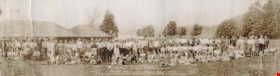
Burnaby Civic Employees Picnic
https://search.heritageburnaby.ca/link/archivedescription35135
- Repository
- City of Burnaby Archives
- Date
- 1949
- Collection/Fonds
- Burnaby Historical Society fonds
- Description Level
- Item
- Physical Description
- 1 photograph : b&w ; 20.2 x 79.0 cm
- Scope and Content
- Photograph of a group of men, women and children at a Burnaby Civic Employees Picnic at Belcarra Park. Some of the people identified in the photograph are: Judith Hunter Conners, Ann Grover, Ed Engberg, John Fredrick Grover, David Hunter, Phyllis Hunter, Jim Grover, Sid [Dote?], possibly Charlie Fo…
- Repository
- City of Burnaby Archives
- Date
- 1949
- Collection/Fonds
- Burnaby Historical Society fonds
- Subseries
- Burnaby Civic Employees subseries
- Physical Description
- 1 photograph : b&w ; 20.2 x 79.0 cm
- Description Level
- Item
- Record No.
- 198-001
- Access Restriction
- No restrictions
- Reproduction Restriction
- No restrictions
- Accession Number
- BHS1987-09
- Scope and Content
- Photograph of a group of men, women and children at a Burnaby Civic Employees Picnic at Belcarra Park. Some of the people identified in the photograph are: Judith Hunter Conners, Ann Grover, Ed Engberg, John Fredrick Grover, David Hunter, Phyllis Hunter, Jim Grover, Sid [Dote?], possibly Charlie Fothergill, and possibly Mrs. Fothergill. An annotation at the bottom centre of photograph reads, "Burnaby Civic Employees / Picnic Belcarra Park July 1949," and at the bottom right of the photo, "Sunday's Photos."
- Names
- Conners, Judith Hunter
- Engberg, Ed
- Fothergill, Charlie
- Grover, Ann
- Grover, Jim
- Grover, John Fredrick
- Hunter, David
- Hunter, Phyllis
- Burnaby Civic Employees Union
- Media Type
- Photograph
- Photographer
- Sunday, Fred William
- Notes
- Title based on contents of photograph
Images


Central Park Arch
https://search.heritageburnaby.ca/link/archivedescription36429
- Repository
- City of Burnaby Archives
- Date
- 1948
- Collection/Fonds
- Burnaby Historical Society fonds
- Description Level
- Item
- Physical Description
- 1 photograph : b&w negative ; 6.5 x 10.5 cm
- Scope and Content
- Photograph of a woman with an infant in her arms, standing under the Central Park Arch at the Kingsway entrance to Central Park. The "Central Park" sign on the arch is electric.
- Repository
- City of Burnaby Archives
- Date
- 1948
- Collection/Fonds
- Burnaby Historical Society fonds
- Subseries
- Martin family subseries
- Physical Description
- 1 photograph : b&w negative ; 6.5 x 10.5 cm
- Description Level
- Item
- Record No.
- 270-001
- Access Restriction
- No restrictions
- Reproduction Restriction
- No known restrictions
- Accession Number
- BHS1991-39
- Scope and Content
- Photograph of a woman with an infant in her arms, standing under the Central Park Arch at the Kingsway entrance to Central Park. The "Central Park" sign on the arch is electric.
- Media Type
- Photograph
- Notes
- Title based on contents of photograph
- 1 b&w photograph accompanying
- Geographic Access
- Central Park
- Imperial Street
- Street Address
- 3883 Imperial Street
- Historic Neighbourhood
- Central Park (Historic Neighbourhood)
- Planning Study Area
- Maywood Area
Images
