More like 'Interview with Leonard Evenden and Allen Seager by Kathy Bossort November 18, 2015 - Track 3'
Narrow Results By
Subject
- Accidents 1
- Accidents - Automobile Accidents 1
- Advertising Medium 1
- Advertising Medium - Signs and Signboards 39
- Aerial Photographs 38
- Agricultural Tools and Equipment 2
- Agricultural Tools and Equipment - Gardening Equipment 4
- Agricultural Tools and Equipment - Plows 2
- Agriculture 3
- Agriculture - Farms 13
- Agriculture - Fruit and Berries 2
- Animals 4
![Joseph Santos at Barnet Marine Park, [2001] thumbnail](/media/hpo/_Data/_Archives_Images/_Unrestricted/535/535-2587.jpg?width=280)
Joseph Santos at Barnet Marine Park
https://search.heritageburnaby.ca/link/archivedescription97059
- Repository
- City of Burnaby Archives
- Date
- [2001]
- Collection/Fonds
- Burnaby NewsLeader photograph collection
- Description Level
- Item
- Physical Description
- 1 photograph (tiff) : col.
- Scope and Content
- Photograph of Joseph Santos in a rain poncho, searching for sea worms on the shores of the Burrard Inlet at Barnet Marine Park. An unidentified person fishing off the pier is visible behind Santos.
- Repository
- City of Burnaby Archives
- Date
- [2001]
- Collection/Fonds
- Burnaby NewsLeader photograph collection
- Physical Description
- 1 photograph (tiff) : col.
- Description Level
- Item
- Record No.
- 535-2587
- Access Restriction
- No restrictions
- Reproduction Restriction
- No restrictions
- Accession Number
- 2018-12
- Scope and Content
- Photograph of Joseph Santos in a rain poncho, searching for sea worms on the shores of the Burrard Inlet at Barnet Marine Park. An unidentified person fishing off the pier is visible behind Santos.
- Media Type
- Photograph
- Photographer
- Bartel, Mario
- Notes
- Title based on caption
- Collected by editorial for use in a July 2001 issue of the Burnaby NewsLeader
- Caption from metadata: "Joseph Santos isn't deterred by the soggy weather as he searches for sea worms to be used as bait at a family fishing expedition at Barnet Marine Park."
- Geographic Access
- Barnet Marine Park
- Burrard Inlet
- Historic Neighbourhood
- Barnet (Historic Neighbourhood)
- Planning Study Area
- Burnaby Mountain Area
Images
![Joseph Santos at Barnet Marine Park, [2001] thumbnail](/media/hpo/_Data/_Archives_Images/_Unrestricted/535/535-2587.jpg)
![Kensington Pitch & Putt, [2000] thumbnail](/media/hpo/_Data/_Archives_Images/_Unrestricted/535/535-3103.jpg?width=280)
Kensington Pitch & Putt
https://search.heritageburnaby.ca/link/archivedescription97999
- Repository
- City of Burnaby Archives
- Date
- [2000]
- Collection/Fonds
- Burnaby NewsLeader photograph collection
- Description Level
- Item
- Physical Description
- 1 photograph (tiff) : col.
- Scope and Content
- Photograph of Joaquin Ortega putting on a green at the Kensington Pitch & Putt course. The snow-covered mountains are visible in the background.
- Repository
- City of Burnaby Archives
- Date
- [2000]
- Collection/Fonds
- Burnaby NewsLeader photograph collection
- Physical Description
- 1 photograph (tiff) : col.
- Description Level
- Item
- Record No.
- 535-3103
- Access Restriction
- No restrictions
- Reproduction Restriction
- No restrictions
- Accession Number
- 2018-12
- Scope and Content
- Photograph of Joaquin Ortega putting on a green at the Kensington Pitch & Putt course. The snow-covered mountains are visible in the background.
- Media Type
- Photograph
- Photographer
- Bartel, Mario
- Notes
- Title based on caption
- Collected by editorial for use in a February 2000 issue of the Burnaby NewsLeader
- Caption from metadata: "A sure sign of Spring is the official opening of the Kensington Pitch & Putt golf course. Joaquin Ortega putts out on a beautiful sunny morning."
- Geographic Access
- Curtis Street
- Street Address
- 5889 Curtis Street
- Planning Study Area
- Parkcrest-Aubrey Area
Images
![Kensington Pitch & Putt, [2000] thumbnail](/media/hpo/_Data/_Archives_Images/_Unrestricted/535/535-3103.jpg)
![Kingsway and Central Park, [196-] thumbnail](/media/hpo/_Data/_Archives_Images/_Unrestricted/001/083-001.jpg?width=280)
Kingsway and Central Park
https://search.heritageburnaby.ca/link/archivedescription34658
- Repository
- City of Burnaby Archives
- Date
- [196-]
- Collection/Fonds
- Burnaby Historical Society fonds
- Description Level
- Item
- Physical Description
- 1 photograph : b&w ; 14.5 x 19.4 cm
- Scope and Content
- Aerial photograph of Kingsway and Central Park.
- Repository
- City of Burnaby Archives
- Date
- [196-]
- Collection/Fonds
- Burnaby Historical Society fonds
- Subseries
- Photographs subseries
- Physical Description
- 1 photograph : b&w ; 14.5 x 19.4 cm
- Description Level
- Item
- Record No.
- 083-001
- Access Restriction
- No restrictions
- Reproduction Restriction
- Reproduce for fair dealing purposes only
- Accession Number
- BHS2007-04
- Scope and Content
- Aerial photograph of Kingsway and Central Park.
- Media Type
- Photograph
- Notes
- Title based on contents of photograph
- Geographic Access
- Kingsway
- Central Park
- Historic Neighbourhood
- Central Park (Historic Neighbourhood)
- Planning Study Area
- Maywood Area
Images
![Kingsway and Central Park, [196-] thumbnail](/media/hpo/_Data/_Archives_Images/_Unrestricted/001/083-001.jpg)
![The Lions from Burnaby Park, [between 1926 and 1929] thumbnail](/media/hpo/_Data/_BVM_Images/1971/197202040003.jpg?width=280)
The Lions from Burnaby Park
https://search.heritageburnaby.ca/link/museumdescription3109
- Repository
- Burnaby Village Museum
- Date
- [between 1926 and 1929]
- Collection/Fonds
- Burnaby Village Museum Photograph collection
- Description Level
- Item
- Physical Description
- 1 photograph : b&w photogravure ; 14.5 x 9.5 cm
- Scope and Content
- Photograph of the north shore mountains, including the Lions, taken from Robert Burnaby Park.
- Repository
- Burnaby Village Museum
- Collection/Fonds
- Burnaby Village Museum Photograph collection
- Description Level
- Item
- Physical Description
- 1 photograph : b&w photogravure ; 14.5 x 9.5 cm
- Scope and Content
- Photograph of the north shore mountains, including the Lions, taken from Robert Burnaby Park.
- Geographic Access
- Wedgewood Street
- Robert Burnaby Park
- Street Address
- 8155 Wedgewood Street
- Accession Code
- HV972.204.3
- Access Restriction
- No restrictions
- Reproduction Restriction
- No known restrictions
- Date
- [between 1926 and 1929]
- Media Type
- Photograph
- Historic Neighbourhood
- Burnaby Lake (Historic Neighbourhood)
- Planning Study Area
- Lakeview-Mayfield Area
- Related Material
- For other photographs from the same album, see HV972.204.3 - .14
- Scan Resolution
- 600
- Scan Date
- 2023-04-25
- Photographer
- Lloyd, Frank Ernest
- Notes
- Annotations made in white paint on recto of photograph read: "'The Lions' from Burnaby Park" and "Lloyd Studio, McKay."
Images
![The Lions from Burnaby Park, [between 1926 and 1929] thumbnail](/media/hpo/_Data/_BVM_Images/1971/197202040003.jpg)
![Lois Hollands-Coutts and Charles Hollands, [1945] (date of original), copied 1991 thumbnail](/media/hpo/_Data/_Archives_Images/_Unrestricted/370/370-429.jpg?width=280)
Lois Hollands-Coutts and Charles Hollands
https://search.heritageburnaby.ca/link/archivedescription37841
- Repository
- City of Burnaby Archives
- Date
- [1945] (date of original), copied 1991
- Collection/Fonds
- Burnaby Historical Society fonds
- Description Level
- Item
- Physical Description
- 1 photograph : b&w ; 4.1 x 2.8 cm print on contact sheet 20.6 x 26.7 cm
- Scope and Content
- Photograph of Lois Holland-Coutts and her father, Charles Hollands, on a path leading to Robert Burnaby Park, near 6th Street at 19th Avenue.
- Repository
- City of Burnaby Archives
- Date
- [1945] (date of original), copied 1991
- Collection/Fonds
- Burnaby Historical Society fonds
- Subseries
- Burnaby Image Bank subseries
- Physical Description
- 1 photograph : b&w ; 4.1 x 2.8 cm print on contact sheet 20.6 x 26.7 cm
- Description Level
- Item
- Record No.
- 370-429
- Access Restriction
- No restrictions
- Reproduction Restriction
- No known restrictions
- Accession Number
- BHS1999-03
- Scope and Content
- Photograph of Lois Holland-Coutts and her father, Charles Hollands, on a path leading to Robert Burnaby Park, near 6th Street at 19th Avenue.
- Media Type
- Photograph
- Notes
- Title based on contents of photograph
- 1 b&w copy negative accompanying
- Negative has a pink cast
- Geographic Access
- 6th Street
- 19th Avenue
- Historic Neighbourhood
- East Burnaby (Historic Neighbourhood)
- Planning Study Area
- Second Street Area
Images
![Lois Hollands-Coutts and Charles Hollands, [1945] (date of original), copied 1991 thumbnail](/media/hpo/_Data/_Archives_Images/_Unrestricted/370/370-429.jpg)
![Lower Mainland, [1946] thumbnail](/media/hpo/_Data/_Archives_Images/_Unrestricted/485/486-039.jpg?width=280)
Lower Mainland
https://search.heritageburnaby.ca/link/archivedescription55645
- Repository
- City of Burnaby Archives
- Date
- [1946]
- Collection/Fonds
- Charles MacSorley fonds
- Description Level
- Item
- Physical Description
- 1 photograph : b&w ; 20.5 x 25.5 cm
- Scope and Content
- Aerial photograph of the Lower Mainland of British Columbia, looking east over Stanley Park and the Burrard Inlet. A printed description accompanying the photograph reads: "A view of the Lower Mainland taken along Burrard Inlet. The block of land in the lower centre of the photograph is Stanley Par…
- Repository
- City of Burnaby Archives
- Date
- [1946]
- Collection/Fonds
- Charles MacSorley fonds
- Physical Description
- 1 photograph : b&w ; 20.5 x 25.5 cm
- Description Level
- Item
- Record No.
- 486-039
- Access Restriction
- No restrictions
- Reproduction Restriction
- No known restrictions
- Accession Number
- 2005-14
- Scope and Content
- Aerial photograph of the Lower Mainland of British Columbia, looking east over Stanley Park and the Burrard Inlet. A printed description accompanying the photograph reads: "A view of the Lower Mainland taken along Burrard Inlet. The block of land in the lower centre of the photograph is Stanley Park with the business section of the City of Vancouver connected thereto. To the left of the Inlet is the City and District of North Vancouver and just above Vancouver is the District of Burnaby. The mountains at the extreme top of the photograph are the Coastal Range and are over a hundred miles away. The mountains to the left can be reached by a fifteen-minute drive from the city. Presented with the compliments of the Corporation of the District of Burnaby."
- Media Type
- Photograph
- Notes
- Title based on caption
- Caption on recto reads: "Lower Mainland"
- Printed description adhered to verso of photograph
Images
![Lower Mainland, [1946] thumbnail](/media/hpo/_Data/_Archives_Images/_Unrestricted/485/486-039.jpg)
![Mayor Derek Corrigan and Stéphane Dion at Burnaby Lake, [2005] thumbnail](/media/hpo/_Data/_Archives_Images/_Unrestricted/535/535-2159-1.jpg?width=280)
Mayor Derek Corrigan and Stéphane Dion at Burnaby Lake
https://search.heritageburnaby.ca/link/archivedescription96537
- Repository
- City of Burnaby Archives
- Date
- [2005]
- Collection/Fonds
- Burnaby NewsLeader photograph collection
- Description Level
- File
- Physical Description
- 2 photographs (tiff) : col.
- Scope and Content
- File contains photographs of Mayor Derek Corrigan touring Burnaby Lake with federal Minister of the Environment Stéphane Dion. Photographs depict Corrigan and Dion on the end of the walkway of Piper Spit, as Corrigan gestures out at Burnaby Lake, and walking the Rotary Walkway with Bill Cunningham.
- Repository
- City of Burnaby Archives
- Date
- [2005]
- Collection/Fonds
- Burnaby NewsLeader photograph collection
- Physical Description
- 2 photographs (tiff) : col.
- Description Level
- File
- Record No.
- 535-2159
- Access Restriction
- No restrictions
- Reproduction Restriction
- No restrictions
- Accession Number
- 2018-12
- Scope and Content
- File contains photographs of Mayor Derek Corrigan touring Burnaby Lake with federal Minister of the Environment Stéphane Dion. Photographs depict Corrigan and Dion on the end of the walkway of Piper Spit, as Corrigan gestures out at Burnaby Lake, and walking the Rotary Walkway with Bill Cunningham.
- Subjects
- Officials - Mayors and Reeves
- Officials - Elected Officials
- Geographic Features - Parks
- Geographic Features - Lakes and Ponds
- Names
- Corrigan, Derek
- Media Type
- Photograph
- Photographer
- Bartel, Mario
- Notes
- Title based on caption
- Collected by editorial for use in a March 2005 issue of the Burnaby NewsLeader
- Caption from metadata for 535-2159-1: "Burnaby mayor Derek Corrigan shows off Burnaby Lake to federal Minister of the Environment, Stephane Dion, during a tour a Piper Spit, part of the city of Burnaby's ongoing quest for funding to dredge the lake."
- Caption from metadata for 535-2159-2: "Burnaby mayor Derek Corrigan shows off Burnaby Lake to federal Minister of the Environment, Stephane Dion, and Bill Cunningham, during a tour along Piper Spit as part of the city of Burnaby's ongoing efforts to secure funding to dredge the lake."
- Geographic Access
- Burnaby Lake
- Burnaby Lake Regional Nature Park
- Historic Neighbourhood
- Burnaby Lake (Historic Neighbourhood)
- Planning Study Area
- Burnaby Lake Area
Images
![Mayor Derek Corrigan and Stéphane Dion at Burnaby Lake, [2005] thumbnail](/media/hpo/_Data/_Archives_Images/_Unrestricted/535/535-2159-1.jpg)
![MP Peter Julian at Burnaby Lake, [2005] thumbnail](/media/hpo/_Data/_Archives_Images/_Unrestricted/535/535-1873-2.jpg?width=280)
MP Peter Julian at Burnaby Lake
https://search.heritageburnaby.ca/link/archivedescription96176
- Repository
- City of Burnaby Archives
- Date
- [2005]
- Collection/Fonds
- Burnaby NewsLeader photograph collection
- Description Level
- File
- Physical Description
- 2 photographs (tiff) : col.
- Scope and Content
- File contains photographs of Burnaby/New Westminster MP Peter Julian posing on a dock by Burnaby Lake and in the rowing pavilion during a press conference related to the federal government's denial of funding for a dredging project.
- Repository
- City of Burnaby Archives
- Date
- [2005]
- Collection/Fonds
- Burnaby NewsLeader photograph collection
- Physical Description
- 2 photographs (tiff) : col.
- Description Level
- File
- Record No.
- 535-1873
- Access Restriction
- No restrictions
- Reproduction Restriction
- No restrictions
- Accession Number
- 2018-12
- Scope and Content
- File contains photographs of Burnaby/New Westminster MP Peter Julian posing on a dock by Burnaby Lake and in the rowing pavilion during a press conference related to the federal government's denial of funding for a dredging project.
- Subjects
- Geographic Features - Lakes and Ponds
- Geographic Features - Parks
- Officials - Elected Officials
- Media Type
- Photograph
- Photographer
- Bartel, Mario
- Notes
- Title based on caption
- Collected by editorial for use in a January 2005 issue of the Burnaby NewsLeader
- Caption from metadata for 535-1873-1: "Burnaby/New Westminster MP Peter Julian says he can't understand why the federal government would deny funding for a dredging project in Burnaby Lake when it approved a similar project for a lake in Saskatchewan."
- Caption from metadata for 535-1873-2: "Burnaby/New Westminster MP Peter Julian gestures towards Burnaby Lake during a news conference at the rowing pavillion to question the federal government's funding of a dredging project at a similar lake in Saskatchewan, while it won't assist a plan to save Burnaby Lake."
- Geographic Access
- Burnaby Lake
- Burnaby Lake Regional Nature Park
- Historic Neighbourhood
- Burnaby Lake (Historic Neighbourhood)
- Planning Study Area
- Burnaby Lake Area
Images
![MP Peter Julian at Burnaby Lake, [2005] thumbnail](/media/hpo/_Data/_Archives_Images/_Unrestricted/535/535-1873-2.jpg)
![Peter Beynon on Rotary Walkway at Burnaby Lake, [2005] thumbnail](/media/hpo/_Data/_Archives_Images/_Unrestricted/535/535-1936.jpg?width=280)
Peter Beynon on Rotary Walkway at Burnaby Lake
https://search.heritageburnaby.ca/link/archivedescription96253
- Repository
- City of Burnaby Archives
- Date
- [2005]
- Collection/Fonds
- Burnaby NewsLeader photograph collection
- Description Level
- Item
- Physical Description
- 1 photograph (tiff) : col.
- Scope and Content
- Photograph of Peter Beynon, president of the Rotary Club of Burnaby, on the Rotary Walkway at Piper Spit on Burnaby Lake. The walkway extends behind him and the viewing deck at the end, Burnaby Lake, and the trees surrounding the lake are visible in the background.
- Repository
- City of Burnaby Archives
- Date
- [2005]
- Collection/Fonds
- Burnaby NewsLeader photograph collection
- Physical Description
- 1 photograph (tiff) : col.
- Description Level
- Item
- Record No.
- 535-1936
- Access Restriction
- No restrictions
- Reproduction Restriction
- No restrictions
- Accession Number
- 2018-12
- Scope and Content
- Photograph of Peter Beynon, president of the Rotary Club of Burnaby, on the Rotary Walkway at Piper Spit on Burnaby Lake. The walkway extends behind him and the viewing deck at the end, Burnaby Lake, and the trees surrounding the lake are visible in the background.
- Subjects
- Geographic Features - Lakes and Ponds
- Geographic Features - Parks
- Structures - Piers and Wharfs
- Media Type
- Photograph
- Photographer
- Medig, Kari
- Notes
- Title based on caption
- Collected by editorial for use in a February 2005 issue of the Burnaby NewsLeader
- Caption from metadata: "Rotary Club of Burnaby president Peter Beynon stands on the new Rotary Walkway at Piper Spit on Burnaby Lake on Wednesday afternoon. The new walkway, a joint venture of local Rotary Clubs, the GVRD, the Pacific Parklands Foundation and Terasen, will be officially unveiled February 23."
- Geographic Access
- Burnaby Lake
- Burnaby Lake Regional Nature Park
- Historic Neighbourhood
- Burnaby Lake (Historic Neighbourhood)
- Planning Study Area
- Burnaby Lake Area
Images
![Peter Beynon on Rotary Walkway at Burnaby Lake, [2005] thumbnail](/media/hpo/_Data/_Archives_Images/_Unrestricted/535/535-1936.jpg)
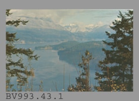
postcard
https://search.heritageburnaby.ca/link/museumartifact35477
- Repository
- Burnaby Village Museum
- Accession Code
- BV993.43.1
- Description
- The postcard face is a colour photo of Indian Arm from Burnaby Mountain Centennial Park in landscape format. Printed in navy on reverse at at upper left, "V-104" "INDIAN ARM FROM BURNABY MOUNTAIN" "Burnaby, B.C." "Looking North-West..."; illustration at left of R.C.M.P. officer; Printed at bottom left, "Photo by H. D. von Tiesenhausen" "S-1464"; This is a navy bar up centre with "PUB. BY NATURAL COLOR PRODUCTIONS, LTD., VANCOUVER, B.C."; at bottom, "MADE IN CANADA" "GRANT-MANN", logo of man, "LITHOGRAPHY" "PHOTOGRAPHY" "DESIGN" Printed at the upper right side of card is an illustration of mounted R.C.M.P. officer to the left of "POST CARD" "ADDRESS" and rectangle for stamp, "USE CANADIAN POSTAGE"; The card is unused
- Object History
- Purchased 1980/1981
- Classification
- Written Communication T&E - - Writing Media
- Object Term
- Postcard
- Country Made
- Canada
- Province Made
- British Columbia
- Site/City Made
- Vancouver
- Title
- Indian Arm from Burnaby Mountain S-1464
- Subjects
- Documentary Artifacts
- Documentary Artifacts - Postcards
- Geographic Features
- Geographic Features - Parks
Images

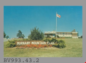
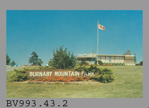
postcard
https://search.heritageburnaby.ca/link/museumartifact35478
- Repository
- Burnaby Village Museum
- Accession Code
- BV993.43.2
- Description
- Postcard: colour photo of Burnaby Mountain Park, Burnaby, BC, including the wooden Burnaby Mountain Park sign and Centennial Pavilion, built for the BC Centennial in 1958; horizontal; on reverse in blue, "2" "BURNABY MOUNTAIN PARK" "Burnaby, B.C., Canada" "The Centennial Pavilion..."; drawing of R.C.M.P. officer at left, mounted officer at right; at lower left, "Photo by George Allen Aerial Photos Ltd. For the Burnaby Parks & Recreation Commission" "S-2773"; blue line up centre with "PUB. BY NATURAL COLOR PRODUCTIONS, LTD., VANCOUVER, B.C."; at bottom, "MADE IN CANADA" "GRANT-MANN"; at upper right, "POST CARD" and rectangle for stamp, "USE CANADIAN POSTAGE"; "ADDRESS" below; unused
- Object History
- Purchased 1980/1981
- Classification
- Written Communication T&E - - Writing Media
- Object Term
- Postcard
- Country Made
- Canada
- Province Made
- British Columbia
- Site/City Made
- Vancouver
- Title
- Burnaby Mountain Park
- Subjects
- Documentary Artifacts
- Documentary Artifacts - Postcards
- Geographic Features
- Geographic Features - Parks
Images
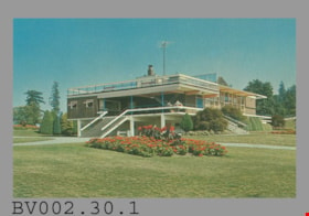
postcard
https://search.heritageburnaby.ca/link/museumartifact44486
- Repository
- Burnaby Village Museum
- Accession Code
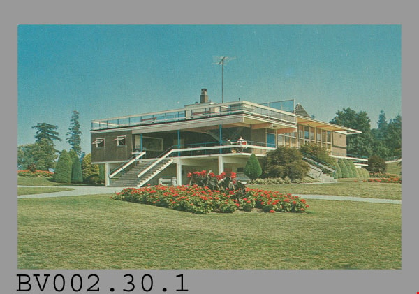
- BV002.30.1
- Description
- Postcard: colour photo of Centennial Pavilion, Burnaby Mountain Park; horizontal; on reverse in navy, "4" "CENTENNIAL PAVILION" "Burnaby, B.C., Canada" "The Centennial Pavilion located..."; illustration at left of R.C.M.P. officer; at bottom, "Photo by George Allen Aerial Photos Ltd. For the Burnaby Parks & Recreation Commission" "S-2775"; navy bar up centre with "NATURAL COLOR PRODUCTIONS, LTD., VANCOUVER, B.C."; at bottom, "MADE IN CANADA" "GRANT-MANN", logo; at upper right, illustration of mounted R.C.M.P. officer, "POST CARD" "ADDRESS", and rectangle "USE CANADIAN POSTAGE"; in blue pen on left side, "July, 1977"
- Classification
- Written Communication T&E - - Writing Media
- Object Term
- Postcard
- Country Made
- Canada
- Province Made
- British Columbia
- Site/City Made
- Vancouver
- Title
- Centennial Pavilion Burnaby, B.C., Canada S-2775
- Publication Date
- July 1977
- Subjects
- Documentary Artifacts
- Documentary Artifacts - Postcards
- Documentary Artifacts - Photographs
- Geographic Features
- Geographic Features - Parks
Images

postcard
https://search.heritageburnaby.ca/link/museumartifact48137
- Repository
- Burnaby Village Museum
- Accession Code
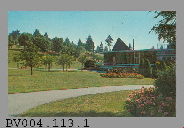
- BV004.113.1
- Description
- Postcard: colour photograph of Burnaby Mountain Park including Centennial Pavilion; horizontal; on reverse in blue: "1" "BURNABY MOUNTAIN PARK" "Burnaby, B.C., Canada" "This park...", drawing of R.C.M.P. officer at left; photo by "George Allen Aerial Photos Ltd. For the Burnaby Parks & Recreation Commission" "S-2772"; blue bar up centre with "PUB. BY NATURAL COLOR PRODUCTIONS, LTD. VANC.-", rest covered; at bottom "MADE IN CANADA" "GRANT-MANN"; green 10 cent stamp at upper right; blue and white "AIR MAIL PAR AVION" label top centre; postmarked "NEW WESTMINSTER B.C. CANADA" "6 -" "17 -" "19--"; cancelled with 7 wavy lines; under "ADDRESS" at right side, in blue pen, "De Heer" "U. Hospes." "Uffo. Emmiresstr. 6." "Sneet"? "Nederland."; message "Hantel Cproetin"? "J. Wisbrands"?; corners slightly worn
- Classification
- Written Communication T&E - - Writing Media
- Object Term
- Postcard
- Marks/Labels
- Burnaby Mountain Park / Burnaby, B.C., Canada / George Allen Aerial Photos Ltd. / Burnaby Parks and Recreation Commission / S-2772
- Country Made
- Canada
- Province Made
- British Columbia
- Site/City Made
- Vancouver
- Title
- Burnaby Mountain Park 1 S-2772
- Publication Date
- [ca. 1970]
- Subjects
- Documentary Artifacts
- Documentary Artifacts - Postcards
- Documentary Artifacts - Photographs
- Geographic Features
- Geographic Features - Parks
Images

postcard
https://search.heritageburnaby.ca/link/museumartifact84669
- Repository
- Burnaby Village Museum
- Accession Code
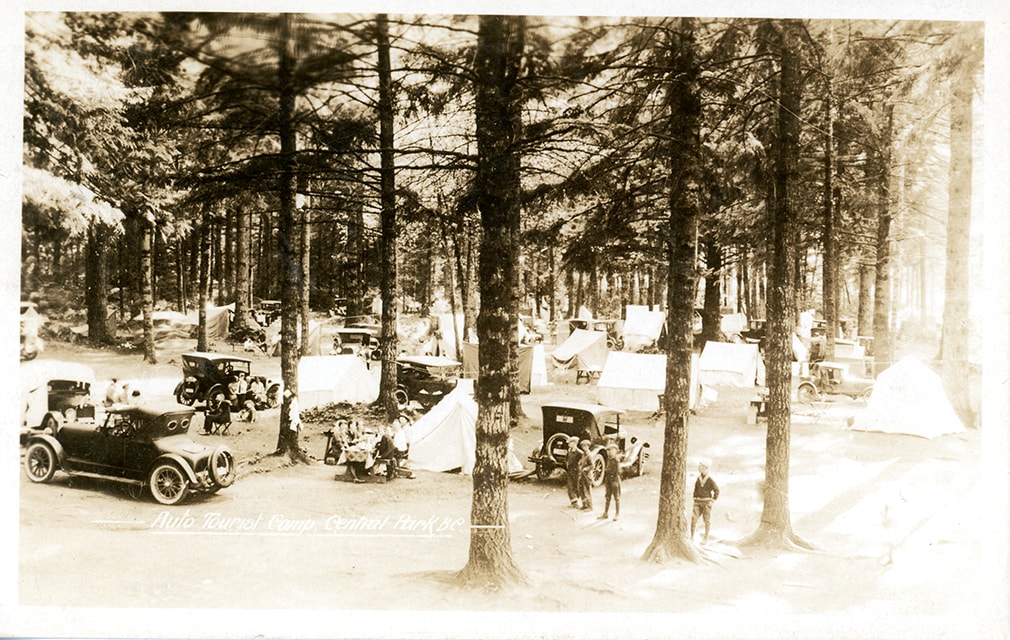
- BV007.43.2
- Description
- postcard; Auto Tourist Camp - Postcard -- [1926]. Postcard with a black and white photograph; inscription in white at bottom reads: "Auto Tourist Camp, Central Park B.C." The postcard was published by the Gowen Sutton Company Limited of Vancouver, BC. Verso of postcard includes a postage stamp with King George in the upper right corner and is post marked Sept. 6 and includes a handwritten letter by "Violet" and is addressed to "Roseline Rondeau.../ Oregon".
- Classification
- Written Communication T&E - - Writing Media
- Object Term
- Postcard
- Colour
- Brown
- Black
- White
- Measurements
- w: 14 cm h: 9 cm
- Country Made
- Canada
- Province Made
- British Columbia
- Site/City Made
- Vancouver
- Subjects
- Documentary Artifacts
- Documentary Artifacts - Postcards
- Geographic Features
- Geographic Features - Parks
- Recreational Activities
- Recreational Activities - Camping
- Names
- Central Park Auto Camp
- Historic Neighbourhood
- Central Park (Historic Neighbourhood)
Images

Stream in Robert Burnaby Park
https://search.heritageburnaby.ca/link/archivedescription93668
- Repository
- City of Burnaby Archives
- Date
- January 15, 1978
- Collection/Fonds
- Burnaby Public Library Contemporary Visual Archive Project
- Description Level
- Item
- Physical Description
- 1 photograph : b&w ; 12.5 x 17.5 cm
- Scope and Content
- Photograph of a mostly dry stream in Robert Burnaby Park. The stream is surrounded by a forested area and the photograph shows a footbridge in the background. The photograph is taken in front of the stream, facing south.
- Repository
- City of Burnaby Archives
- Date
- January 15, 1978
- Collection/Fonds
- Burnaby Public Library Contemporary Visual Archive Project
- Physical Description
- 1 photograph : b&w ; 12.5 x 17.5 cm
- Description Level
- Item
- Record No.
- 556-625
- Access Restriction
- No restrictions
- Reproduction Restriction
- Reproduce for fair dealing purposes only
- Accession Number
- 2017-57
- Scope and Content
- Photograph of a mostly dry stream in Robert Burnaby Park. The stream is surrounded by a forested area and the photograph shows a footbridge in the background. The photograph is taken in front of the stream, facing south.
- Media Type
- Photograph
- Photographer
- Surridge, Jack
- Notes
- Title taken from project information form
- Accompanied by a project information form and 1 photograph (b&w negative ; 9.5 x 12.5 cm)
- BPL no. 74
- Geographic Access
- Robert Burnaby Park
- Historic Neighbourhood
- Burnaby Lake (Historic Neighbourhood)
- Planning Study Area
- Lakeview-Mayfield Area
Images


Trail through the woods of Stoney Creek School
https://search.heritageburnaby.ca/link/archivedescription58924
- Repository
- City of Burnaby Archives
- Date
- ca.1980
- Collection/Fonds
- Columbian Newspaper collection
- Description Level
- Item
- Physical Description
- 1 photograph : b&w ; 25.5 x 20.5 cm
- Scope and Content
- Photograph of a paved trail through the woods by Stoney Creek Community School. A parking lot with cars is visible at the end of the trail.
- Repository
- City of Burnaby Archives
- Date
- ca.1980
- Collection/Fonds
- Columbian Newspaper collection
- Physical Description
- 1 photograph : b&w ; 25.5 x 20.5 cm
- Description Level
- Item
- Record No.
- 480-1375
- Access Restriction
- No restrictions
- Reproduction Restriction
- Reproduce for fair dealing purposes only
- Accession Number
- 2009-01
- Scope and Content
- Photograph of a paved trail through the woods by Stoney Creek Community School. A parking lot with cars is visible at the end of the trail.
- Media Type
- Photograph
- Photographer
- King, Basil
- Notes
- Title based on contents of photograph
- Note on recto reads: "Trail thru woods & Stoney Creek School"
- Note on verso reads: "PMT 100% / page 1 / Burnaby Today"
- Photographer's stamp on verso
- Street Address
- 2740 Beaverbrook Crescent
- Historic Neighbourhood
- Burquitlam (Historic Neighbourhood)
- Planning Study Area
- Lyndhurst Area
Images

![Barkerville in the '30s, [193-] thumbnail](/media/hpo/_Data/_Archives_Images/_Unrestricted/001/020-060.jpg?width=280)
Barkerville in the '30s
https://search.heritageburnaby.ca/link/archivedescription34353
- Repository
- City of Burnaby Archives
- Date
- [193-]
- Collection/Fonds
- Burnaby Historical Society fonds
- Description Level
- Item
- Physical Description
- 1 photograph : b&w ; 7.2 x 12 cm on page 17.5 x 26.5 cm
- Scope and Content
- Photograph of the town of Barkerville. Barkerville was a central town during the Cariboo Gold Rush. Photograph shows the town with a hill being cleared in the background. This photograph appears to have been taken by Arthur Peers, who travelled through the Fraser River Valley and worked on the c…
- Repository
- City of Burnaby Archives
- Date
- [193-]
- Collection/Fonds
- Burnaby Historical Society fonds
- Subseries
- Peers family subseries
- Physical Description
- 1 photograph : b&w ; 7.2 x 12 cm on page 17.5 x 26.5 cm
- Description Level
- Item
- Record No.
- 020-060
- Access Restriction
- No restrictions
- Reproduction Restriction
- No known restrictions
- Accession Number
- BHS2007-04
- Scope and Content
- Photograph of the town of Barkerville. Barkerville was a central town during the Cariboo Gold Rush. Photograph shows the town with a hill being cleared in the background. This photograph appears to have been taken by Arthur Peers, who travelled through the Fraser River Valley and worked on the construction of the Trans-Provincial Highway during the later 1920s.
- Media Type
- Photograph
- Photographer
- Peers, Arthur Francis "Mike"
- Notes
- Title based on caption accompanying photograph
Images
![Barkerville in the '30s, [193-] thumbnail](/media/hpo/_Data/_Archives_Images/_Unrestricted/001/020-060.jpg)

Barnet Wagon Road
https://search.heritageburnaby.ca/link/archivedescription38306
- Repository
- City of Burnaby Archives
- Date
- June 1903 (date of original), copied ca. 1990
- Collection/Fonds
- Burnaby Historical Society fonds
- Description Level
- Item
- Physical Description
- 1 photograph : b&w ; 10 x 15 cm print
- Scope and Content
- Photograph of the Barnet Wagon Road looking west from Sperling Avenue.
- Repository
- City of Burnaby Archives
- Date
- June 1903 (date of original), copied ca. 1990
- Collection/Fonds
- Burnaby Historical Society fonds
- Subseries
- Photographs subseries
- Physical Description
- 1 photograph : b&w ; 10 x 15 cm print
- Description Level
- Item
- Record No.
- 403-001
- Access Restriction
- No restrictions
- Reproduction Restriction
- No known restrictions
- Accession Number
- BHS2007-04
- Scope and Content
- Photograph of the Barnet Wagon Road looking west from Sperling Avenue.
- Subjects
- Land Clearing
- Geographic Features - Roads
- Media Type
- Photograph
- Notes
- Title based on contents of photograph
- Geographic Access
- Barnet Road
- Sperling Avenue
- Historic Neighbourhood
- Lochdale (Historic Neighbourhood)
- Planning Study Area
- Westridge Area
Images


Barnet Wagon Road
https://search.heritageburnaby.ca/link/archivedescription38307
- Repository
- City of Burnaby Archives
- Date
- June 1903 (date of original), copied ca. 1990
- Collection/Fonds
- Burnaby Historical Society fonds
- Description Level
- Item
- Physical Description
- 1 photograph : b&w ; 10 x 15 cm print
- Scope and Content
- Photograph of the Barnet Wagon Road looking east, near Barnet and Hastings.
- Repository
- City of Burnaby Archives
- Date
- June 1903 (date of original), copied ca. 1990
- Collection/Fonds
- Burnaby Historical Society fonds
- Subseries
- Photographs subseries
- Physical Description
- 1 photograph : b&w ; 10 x 15 cm print
- Description Level
- Item
- Record No.
- 403-002
- Access Restriction
- No restrictions
- Reproduction Restriction
- No known restrictions
- Accession Number
- BHS2007-04
- Scope and Content
- Photograph of the Barnet Wagon Road looking east, near Barnet and Hastings.
- Subjects
- Land Clearing
- Geographic Features - Roads
- Media Type
- Photograph
- Notes
- Title based on contents of photograph
- Geographic Access
- Barnet Road
- Hastings Street
- Historic Neighbourhood
- Lochdale (Historic Neighbourhood)
- Planning Study Area
- Westridge Area
Images

![Burrard Inlet, [1912] (date of original), copied 1986 thumbnail](/media/hpo/_Data/_Archives_Images/_Unrestricted/204/204-704.jpg?width=280)
Burrard Inlet
https://search.heritageburnaby.ca/link/archivedescription35845
- Repository
- City of Burnaby Archives
- Date
- [1912] (date of original), copied 1986
- Collection/Fonds
- Burnaby Historical Society fonds
- Description Level
- Item
- Physical Description
- 1 photograph : b&w ; 12.7 x 17.8 cm print
- Scope and Content
- Photograph of Burrard Inlet taken looking north from Capitol Hill.
- Repository
- City of Burnaby Archives
- Date
- [1912] (date of original), copied 1986
- Collection/Fonds
- Burnaby Historical Society fonds
- Subseries
- Pioneer Tales subseries
- Physical Description
- 1 photograph : b&w ; 12.7 x 17.8 cm print
- Description Level
- Item
- Record No.
- 204-704
- Access Restriction
- No restrictions
- Reproduction Restriction
- No known restrictions
- Accession Number
- BHS1988-03
- Scope and Content
- Photograph of Burrard Inlet taken looking north from Capitol Hill.
- Media Type
- Photograph
- Photographer
- Phillips, James William "Jim"
- Notes
- Title based on contents of photograph
- Historic Neighbourhood
- Capitol Hill (Historic Neighbourhood)
- Planning Study Area
- Capitol Hill Area
Images
![Burrard Inlet, [1912] (date of original), copied 1986 thumbnail](/media/hpo/_Data/_Archives_Images/_Unrestricted/204/204-704.jpg)